Earthquake swarm 43 km west of Grímsey island

A minor earthquake swarm took place around 43 km west of Grímsey island. The largest earthquakes in this swarm where not felt because of distance from populated areas. This earthquake swarm took place on a north end of a rift valley that is at this location and goes all the way to Akureyri and little south of Akureyri town. Where it ends is unclear.

Green stars far west of Grímsey island on the map from Icelandic Met Office with the time at 23:00 UTC on 5. April 2023. This earthquake swarm is far north of Akureyri town.
Earthquake swarm on Tjörnes Fracture Zone. Copyright of this image belongs to Icelandic Met Office.

Largest earthquake in this small earthquake swarm had a magnitude of Mw3,5. This area had a large earthquake swarm in June 2020 with the largest earthquake in that swarm reaching magnitude of Mw5,8 that was felt over a large area in north Iceland. Large earthquake swarms happen in this rift valley regularly. I am not sure how often it does happen. More earthquakes in this area might be possible without any warning. Distance from land makes it difficult to record earthquakes at this location if they are small in magnitude.

Earthquake swarm in Fremrinámar volcano

An earthquake swarm in a volcano called Fremrinámar today (30. March 2023). This is the first time I’ve seen an earthquake swarm in this volcano. All earthquakes where small in magnitude and the magnitude range was from Mw0,1 to Mw1,0. Depth was 5,8 km to 9,1 km.

Fremrinámar volcano is located on this image south of Krafla volcano, located close to Mývatn lake in eastern north Iceland. Few orange dots are on the map showing the earthquake activity.
Fremrinámar is located south of Krafla volcano. Copyright of this image belongs to Icelandic Met Office.

This is the first time I’ve seen an earthquake activity in this volcano. I’ve been monitoring earthquake activity for close to 30 years at the writing of this article. Last eruption in Fremrinámar volcano took place around 3200 years ago (1200 BCE according to Global Volcanism Program). There is a second (and I assume newly discovered) volcano north of Fremrinámar volcano and south of Krafla volcano called Heiðarsporðar. That volcano last erupted around 2200 years ago. This earthquake activity doesn’t seems to be in that volcano, but this map on Icelandic Met Office website is not fully up to date it seems. Based on the volcano website Catalogue of Icelandic Volcanoes. This earthquake activity is only mentioned here now, because I’ve never seen an earthquake swarm in this volcano before.

Earthquake swarm in Brennisteinsfjöll volcano (Bláfjöll mountain)

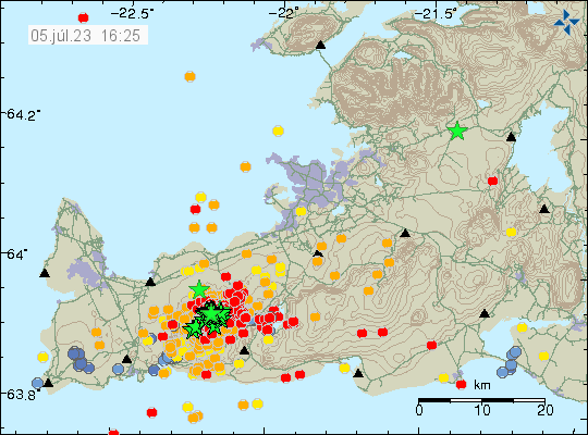
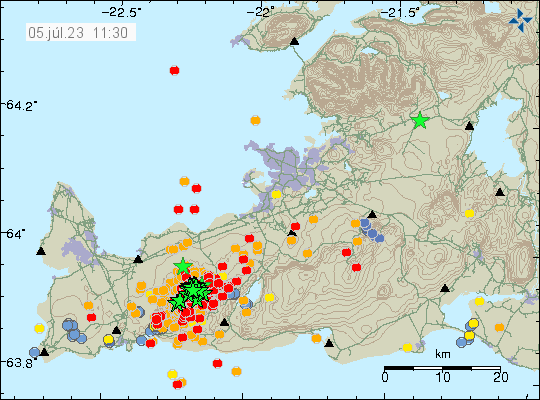
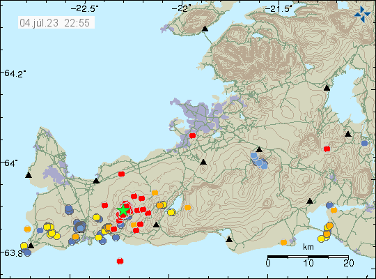
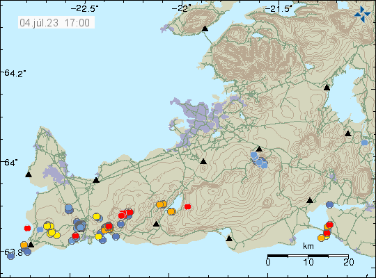
Earlier this week, an swarm of earthquakes started in south of Brennisteinsfjöll volcano, also known as Bláfjöll mountain. This earthquake swarm started on a west to east fault north of a lake called Hlíðarvatn. This earthquake swarm has only been minor earthquakes, with magnitudes in the range of Mw0,0 and up to Mw2,3 but at the writing of this article, nothing above that magnitude. Over the week this earthquake swarm has evolved into a single area that seems to be circular, based on current earthquake activity. This strongly suggests that magma is the reason why this earthquake swarm is happening.

Red dots in south of Brennisteinsfjöll volcano. Showing the earthquake activity in that volcano. Red dots are also visible in Hengill volcano in a unrelated earthquake swarm.
Earthquake activity in Breinnisteinsfjöll volcano. Copyright of this image belongs to Icelandic Met Office.
Dots in different sized showing the earthquake swarm in Brennisteinsfjöll volcano. This is a image from Skjálfta-lísa website from Icelandic Met Office.
Earthquake as they appear on Skjálfta Lísa website from Icelandic Met Office. Screenshot from Icelandic Met Office website Skjálfta Lísa.
Google Earth image of the area where this earthquake swarm is taking place. It shows the road, the Hlíðarvatn lake and other feature in the landscape. Including a old lava flow the west of the current earthquake swarm. The landscape also seems to show older craters at this location, but those are weathered down to almost nothing.
Google Earth image of the area where the earthquake swarm is taking place. Picture is from Google Earth.

At the writing of this article, the earthquake activity is too small to start an eruption. Since this area is cold and the crust is too hard for the magma to flow freely inside it. Current depth of the earthquakes is around 5 to 7 km at the writing of this article and has not changed a lot during the week. While the Skjálfta Lísa image does not show this, it is possible that the earthquake activity has started to spread more east, compared to earlier in the week when this activity started. This earthquake actiivty might stop, as often happens in the early stages of a new eruption cycle in a volcano.

Earthquake activity in Bárðarbunga volcano

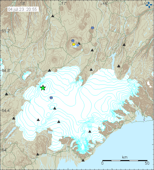
Today (19. March 2023) at 14:59 UTC an earthquake with magnitude of Mw3,1 took place in Bárðarbunga volcano. This is normal earthquake activity and shows the inflation that is happening in Bárðarbunga volcano is ongoing after the end of the eruption in 2015.

Vatnajökull glacier, in north-west of it, close to the edge of the glacier there's a green star and a red dot were the Bárðarbunga volcano is and it shows the earthquake activity that happened today.
Earthquake activity in Bárðarbunga volcano. Copyright of this image belongs to Icelandic Met Office.

This type of earthquake activity happens once to twice a month with a earthquake close to magnitude five happening every three to four months. This earthquake activity is getting lower with time, it is likely that it is going to take few more years until it completely stops.

Early signs of next eruption phase in Fagradalsfjall volcano

Since end of February 2023 there have been slowly growing signs in form of a small earthquake activity in Fagradalsfjall volcano and nearby area. It is impossible to know when next eruption starts in Fagradalsfjall volcano, but last time the quiet time was around 10 months. If it is going to be shorter or longer now is impossible to know.

Red dots and orange dots, not many of them in Fagradalsfjall volcano, in Krýsuvík-Trölladyngja volcano east of Fagradalsfjall and orange and blue dots west of Fagradalsfjall volcano in the volcano Reykjanes.
Earthquake activity in Fagradalsfjall volcano. Copyright of this image belongs to Icelandic Met Office.

Currently the earthquake activity is minor, but that can change quickly and without much warning. At the writing of this article, its been 6 months and 24 days since the eruption in Meradalir valley ended. I don’t know if this is going to happen the same was as it did before last eruption. Since there’s a lot of magma at depth of 5 to 10 km now and that changes how everything functions and behaves in the crust.

Earthquake activity in Askja volcano

Yesterday (14. March 2023) at 20:43 UTC an magnitude Mw3,0 earthquake took place in Askja volcano. This is just one of smaller earthquakes in Askja volcano. There have been almost no earthquake activity following the inflation in Askja volcano in recent months. Suggesting to me (this is my personal opinion) that this inflation is not going to result in a eruption. Deflation might start in few months or years time, if it starts at all. Why this happens the way it does is unknown to me.

Earthquake activity in the inner caldera of Askja volcano. Shown with blue, yellow and orange dots. There is some earthquake activity east of Askja volcano in Herðubreið mountain and nearby area.
Earthquake activity in Askja volcano. Copyright of this image belongs to Icelandic Met Office.

It is my personal view that earthquake activity in Askja volcano is going remain low and even vanish for a time. I don’t think anything is going to happen this time around. I am however known to get this wrong, because nobody can be sure what happens next in a volcano.

Earthquake activity in western part of Katla volcano

This morning (11. March 2023) at 07:02 UTC an earthquake with magnitude of Mw3,1 took place in western part of Katla volcano. This earthquake happened in Katla volcano caldera rim. The depth was 1,1 km. This was a single earthquake, at the writing of this article.

Green star in the western part of Katla volcano caldera. This is just a one star and one orange dot showing smaller earthquake slightly north of this earthquake.
Earthquake activity in Katla volcano. Copyright of this image belongs to Icelandic Met Office.

Since this earthquake there has not been any new earthquake activity in Katla volcano. I am not sure why that is, but it there’s a chance this earthquake activity might just be over. There has been a lot of frost quakes in last few hours, because of a cold weather happening in Iceland. With freezing going down to -20C in some areas.

Earthquake swarm east of Grímsey island in Tjörnes Fracture Zone

Yesterday (9. March 2023) and today (10. March 2023) an earthquake swarm has been east of Grímsey island. Largest earthquake in this swarm had a magnitude of Mw3,8. There have been around 40 to 60 earthquakes in this swarm. Making this earthquake swarm rather small, compared to many other earthquake swarm that have been at this same location.

Green star east of Grímsey island, in a circle that shows a submarine volcano at the same area. Red dots are in the same area showing smaller earthquakes.
Earthquake activity east of Grímsey island. Copyright of this image belongs to Icelandic Met Office.

This earthquake swarm seems to be ongoing at of the writing of this article. It is impossible to know for sure if an stronger earthquake is going to happen in this area.

Earthquake swarm in Katla volcano

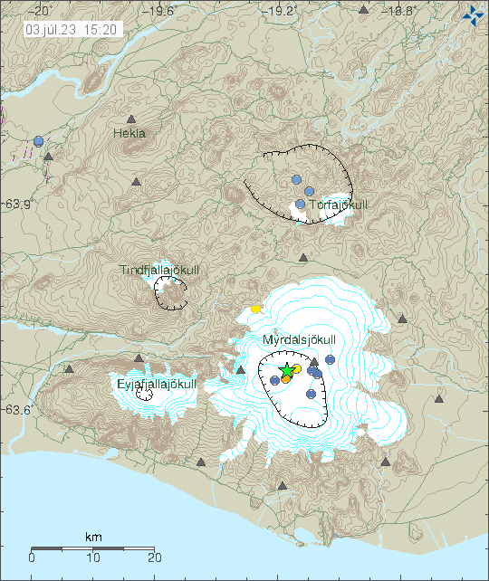
Today (9. March 2023) an earthquake swarm started in Katla volcano. This earthquake swarm is ongoing and information in this article can go outdated quickly. Largest earthquakes at the writing of this article have a magnitude of Mw3,3 and Mw3,4. A swarm of smaller earthquakes is ongoing.

Two green stars in Katla volcano askja in Mýrdalsjökull glacier. Along with many red dots that show smaller earthquakes in Katla volcano.
Earthquake activity in Katla volcano. Copyright of this image belongs to Icelandic Met Office.

It is difficult to know for sure what is going on in Katla volcano. But this activity reminds me of what happened few years ago before an small eruption took place in Katla volcano. If that is going to happen now I don’t know. I’ll post information when I know more and if anything more happens in Katla volcano.

Earthquake swarm north of Herðubreið mountain

Yesterday (5. March 2023) at 18:00 UTC an earthquake with magnitude Mw3,4 took place north of Herðubreið mountain. This is a small earthquake swarm and is part of an ongoing earthquake swarm in this area that has been going on since October 2022 (or in around that month).

Green star and red dots north of Herðubreið mountain, that is located north-east of Askja volcano. Smaller earthquakes in Askja volcano shown with blue and yellow dots.
Earthquake activity north of Herðubreið mountain. Copyright of this image belongs to Icelandic Met Office.

Depth of this earthquake was only 4,2 km and earthquake activity in this area has been getting shallower with time. If this is magma, then there’s not a lot of it at this depth. Earthquake activity is small compared to the earthquake swarms that happen just before an eruption. It is clear that, if this is magma, it is not pushing its way up the surface at this point in time.