This is going to be a short article, as the current situation is constantly changing.
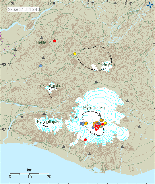
Earthquake swarm started around 03:00 UTC (29-September-2016) in Katla volcano, this earthquake swarm has been heavy due to high number of earthquakes, when this is written around 88 earthquakes have been recorded in Katla volcano. This number is going to change as the earthquake activity continues.

The earthquake activity in Katla volcano. Copyright of this image belongs to Icelandic Met Office.
According to a statement that Icelandic Met Office issued the conductivity in glacier rivers from Katla is higher than normally during this time of year. At current it is 190uS and according to the Icelandic Met Office this is not normal during this time of the year. At the present no harmonic tremor has appeared, if it appears it is going to be clear on the SIL stations around Katla and maybe good distance away from the volcano. As it is going to override any background noise that might be happening (wind, noise, traffic).
This article is going to be updated as I learn more.
Update at 19:00 UTC
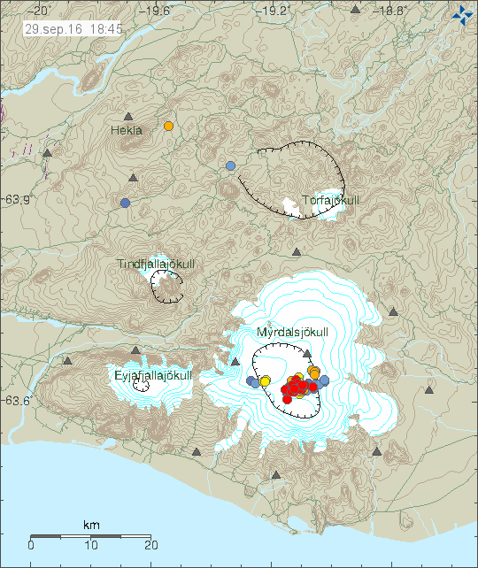
The earthquake activity has continued today as before, there have been small drops in activity for up to a hour, after that the earthquake activity continues. Currently (when this is written) there is a low in the earthquake activity. Largest earthquake was at 16:28 UTC and had the magnitude of 3,0. Other earthquakes have been smaller in magnitude.

The earthquake activity at 18:45 UTC. Copyright of this image belongs to Icelandic Met Office.
Update on earthquake area location
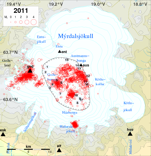
Most of the earthquake activity today (29-September-2016) has been taking place north of cauldron 16 (see map). This makes it less likely to be connected to hydrothermal area and changes in that type of area. Since hot-springs create the cauldron seen in the Mýrdalsjökull glacier, the heat melts the bottom of the glacier and creating glacier outburst once in a while. It does appear that the earthquake activity has extended it self into cauldrons 10 and 11 and maybe cauldron 16, but I’m not sure on that detail currently.

Earthquake activity in Katla after the year 2011. Cauldrons are marked with numbers and location on this map. Copyright of this map belongs to Icelandic Met Office. Source link.
Article updated at 16:05 UTC. Time corrections on when this activity started.
Article updated at 19:00 UTC. Updated added.
Article updated at 19:47 UTC. Map added from 2011.

According to RUV(in icelandic), IMO had a meeting this afternoon due to this activity in Katla. No statement from them yet other than they will continue to monitor her 24/7.
http://www.ruv.is/frett/aukin-skjalftavirkni-i-kotluoskju
Mayby the eruption is already in progress? Lava is trying to break through the glacier?
No. That leaves a signature on the SIL network in form of a volcanic harmonic tremor. That has not yet been detected. Until that happens, this is just a earthquake swarm.
Thanks for the answer. Anyway, the princess opens one eye after a nap 😉
Very interesting to see this development! How come almost all the earthquakes are so shallow, almost at surface level? Or have I missed any deep EQs indicating rising magma?
Strongest EQ of this ongoing swarm occurred just now, at UTC 16:25. Could well be a green star coming up.
Or perhaps two or more M1-M2 earthquakes at once. The (still not manually checked) data at IMO points to that.
This might be hydrothermal earthquakes responding to some changes at depth, making them shallow for that reason. However this earthquake swarm has been going on for more then 12 hours and shows no signs of stopping, once the hydrothermal areas have boiled something else is going to happen. What that is I don’t know yet.
it looks like powerful quake…. (couple secs ago)
On stratovolcano (like Katla), it’s not necessary to have armonic tremor. Those occures only on eruption based on bazic magma (and those have indeed lava flows). But can be also acidic magma who trigers piroclastic exlposions and the eruption do not have lava flows (see Bandai-San volcano) A stratovolcano sistem means that the volcanic cone is formed by alternating deposits of lava and piroclastic flows. . And it’s not enough historical data to know if a piroclastic eruption on Katla (if occurs) can have armonic tremors (maybe magma can be to acidic [viscous] ) to flow…. What I don’t know if the increased glaciar river conductivity is from acidic nature ….
Harmonic tremor is going to appear due to magma – glacier interactions. In 2011 when a minor eruption took place in Katla volcano the harmonic tremor did go sky high.
You can find those articles and images here. They are all from July, 2011.
http://icelandgeology.net/?p=1130
http://icelandgeology.net/?p=1139
http://icelandgeology.net/?p=1171
Largest earthquake at 16:28 UTC had the magnitude of 3,0.
in 0,1 km deep ! That has nothing to do with Vulkanismus !
It’s probably measured against sea level, so around 1,5 km below the summit.
The measurement is taken against the surface, not sea level. But there is a error in this measurement of +-200 – 400 meters. The depth range is from 0,1 – 0,5 km, but that never is mentioned as it adds complexity reading the data if that would be done (the geologist them self are aware of this error margin).
Thanks for your hard work at keeping us informed Jon!
Is there a web cam that monitors the area the swarm is mainly located on or near? Because if there is an eruption I would love to be watching like I was when Bardarbunga went off. That was a totally awesome experience.
You can always watch Míla Katla webcam. It streams live. For the moment you are only going to see the dark.
http://www.livefromiceland.is/webcams/katla/
I remember watching one of the Bard cams in the dark about an hour or so before the eruption, scientists turned up (car headlights) in roughly the area the eruption happened (or so it seemed).
I guess we’ll find out soon enough if this is a dress rehearsal for Katla or the beginning of the main event.
Trying to understand what you are saying Jón: it is likely that the hotsprings, causing the cauldrons are melting the glacier. This meltingnis causing the earthquakes and in that sence, an eruption is not likely. Am I right so far? ?
But, what I am thinking: why are the hotsprings heating up that much? Is that lava?
You are almost correct.
1: The glacier above Katla is up to 600 meters thick.
2: The hydrothermal areas in the volcano melt the bottom of the glacier.
3: This melting sometimes results in glacier floods from Mýrdalsjökull, normally in the summer.
4: Sometimes pressure changes within the hydrothermal areas create earthquake swarms. This is normally due the hydrothermal areas getting hotter under the pressure of the glacier.
5: The hydrothermal areas in Katla are warming up as magma enters shallower levels in the crust. This is common in volcanoes and is often sign of an imminent eruption, sometimes the hydrothermal areas do warm up without an eruption, that is often due to superheated gas going up the crust (under pressure).
Its all really complicated and I don’t know if the interactions between the hydrothermal areas and the glacier are fully understood today, even if there has been a lot of effort in documenting the caldera in Katla trough the glacier.
Great Jón, thank you so much for this clear explanation!
Jón what do you think the chances are that an eruption could occur in the next few days, seeing that she has been making a lot of noice in recent weeks. If this swarm continues could we see the “overdue” eruption happen in the next few days?
It is almost impossible to know this for sure. If the current activity doesn’t stop the odds are high, but Katla volcano has shown the pattern of increased activity that can quiet down over period of days and not resulting in a eruption. For the moment all that can be done is to wait and see.
Thanks for the reply, it would be amazing to see the big sister in all its glory, now i just gotta stay tuned on the live webcam for awhile 😛
I thought I could see smoke on the web cam this afternoon.
What I say, no Vulkanismus !!!!!!
1. There is currently no signs for an immanent eruption.
2. The tremor visible since the 27th is due to an ongoing jökulhlaup.
3. The current earthquake swarm is normal for the season, it occurs at a normal spot, and at a normal depth and they are so far of normal size. Nor is this swarm unusually large.
4. The earthquakes are caused by loss of weight. The weight loss is caused by 1 meter of ice having melted away due to the unusually warm summer. There has also been a series of minor Jökulhlaups from Katla in the last two months. This means that the average loss of ice this year is between 2 and 5 meters for the entire Caldera. The loss of ice is uniform all over the caldera.
5. This swarm contains no earthquakes deeper than 1km with the bulk of them being at 0.1km depth. This is consistent with glacial rebound earthquakes and inconsistent with a volcano closing in on an eruption.
6. All earthquakes in the swarm are of tectonic type with no fluid component.
7. An eruption would look like a very large nuclear bomb going off. Unless you see that it is a cloud, the sun, sheep, a car, a farmer, a helicopter, or a flying sheep. To cut it short, unless you are screaming “Holy Crap” it is not an eruption.
What would we expect IF Katla would erupt in the near future.
An intense earthquake swarm with about 100 earthquakes an hour with depths ranging from 0 to 10km depth with magnitudes up to, but not limited to, M5. There would also be different earthquake signatures indicating movement of magma and harmonic tremor as magma moves up the conduits. We are basically talking about activity that is 100 to 100 000 times more intense than we are seeing now.
This is terribly wrong. The main reason is that this looks like a pre-sequence to an volcano eruption. Current earthquake activity is minor, but it has two signs that suggest that more is about to happen.
1: Earthquake activity is growing in magnitude and has been doing so since around 16:00 UTC 29-September-2016.
2: The earthquake activity is continuous, it doesn’t stop and has now been ongoing for close to 20 hours (it is going to get to 24 hours at 03:00 UTC).
Each volcano is different on how it behaves before an eruption. I suspect that the magma system in Katla volcano is now an overpressure and a fault has developed in in the magma chamber, where the current activity is taking place. The reason you don’t see any deep earthquakes in this area is simple, the rock has already been boiled out and is now so soft it is unable to break to form an earthquake. This at least is a possible idea, I don’t this has been proven so far with any measurements yet.
We won’t see any moderate earthquakes (magnitude 5 and stronger) until the magma starts to pressure it self out of the magma chamber in an eruption. When that happens in anyone guess.
This is of course also a possibility. We’ll see what happens. I think it’s a glacier run. 🙂
Could it just be the ice collapsing into th caldera because the water has run out from underneath it.?
Looks like earthquake activity in Katla has just picked up again after a very brief lull.
And now Katla has a star, how pretty.
Strong quake(s)!
http://hraun.vedur.is/ja/alert/2016/sep/30/023.html
Magnitude of quakes is going up: 3.2, 3.1 and 3.6 this morning alone.
This might be the beginning of long rumble on the road to eruption. Let’s see how it goes.
There is a beautifullrainbow on that webcam at the moment!
and i need more tea to type it seems!
I agreed! It’s fantastic! 🙂
Wauw, Katla is so beautiful now on the webcam, stunning….
Looks like another lull, nearly an hour without a quake, but I think she will start again soon, gif not then she gave us some drama lol.
Next update (new article) is going to be around 10:00 – 11:00 UTC. I need to go to the bank and the store and I don’t know exactly how long that is going to take.
A recent study shows that a near-future like Jon said is possible.
http://onlinelibrary.wiley.com/doi/10.1002/2015GC006118/full
Data suggest shallow magma storage as well as a deeper one.
However, as long as IMO shows no imminent signs of unrest there is not too much to worry about.
More tremors are deeper now. Most of them (1.1-1.8km). One of them (9.8km)
1.1 km is a default depth from the automatic systems (I have no idea why). Once these earthquakes have been manually checked the depth is also being corrected.
You can spot manually checked EQs by the ‘Quality’ column being 99.0.
I think it is the glacier ice collapsing because water has run out from under it and it is no longer supported. Perhaps you will see more of this from global warming.
Highly unlikely because of the nature of the very big structure. Small holes and rivers in a big piece of glass. More likely with cracks and movements in the ice. When hot gas reaches the cracks they will grow. When the pressure is high enough and the cracks are big enough it will be an explosion. Otherwise it will stream out under the ice with some tremor.
Global warming doesn’t cause earthquakes and neither does collapsing ice.
A million tonne block of ice falling a metre or more might not cause an earthquake … but I suspect is will rattle the bejeusus out of any nearby seismographs.
Global warming causes increased atmospheric CO2!
IMO have changed the aviation code for Katla volcano from green to yellow.