
The current inflation that is now happening on the Reykjanes peninsula below the tuff mountain called Þorbjörn is in a volcano system called Reykjanes in the Global Volcanism Program. Last eruption is registered having taken place in Mars 1831 at Eldeyjarboði but given the location and distance on the Reykjanes ridge that area possibly is part of a different volcano system and is not connected to the Reykjanes volcano system that now has become active. Part of this volcano is below sea level. Maps of this area can be found here and here (image). Last eruption in this system was maybe in the year 1583. There is a possibility that the eruption in the year 1583 belongs to a different volcano system that is completely under the ocean. Last confirmed eruption in this system was in the year 1240 (780 years). More information on the volcano can also be found here.
The volcano that is now active doesn’t have any special name so for clarity I am just going to call it Þorbjörn. This volcano is rather large and erupts in the form of fissure vents. Þorbjörn is inside a fissure zone of the volcano called Reykjanes and that volcano might be the main volcano in this system and it can happen that both volcanoes can erupt at the same time. I don’t know if that is going to happen this time around but there has been a earthquake activity in the main volcano called Reykjanes and part of it is below ocean and eruption that would result in ash cloud with limited distribution. This earthquake activity suggests that both volcanoes are now getting active. The volcano called Reykjanes is less dangerous because its out in the ocean and not close to any populated area. Þorbjörn is close to populated area and important infrastructure on the Reykjanes peninsula.
I have written about this area earthquake activity in last few weeks here (28-July-2017), here (15-December-2019), here (17-December-2019), here (19-December-2019), here (20-December-2019), here (22-January-2020). I do think this is all of the earthquake activity in this area since July 2017 until January 2020.
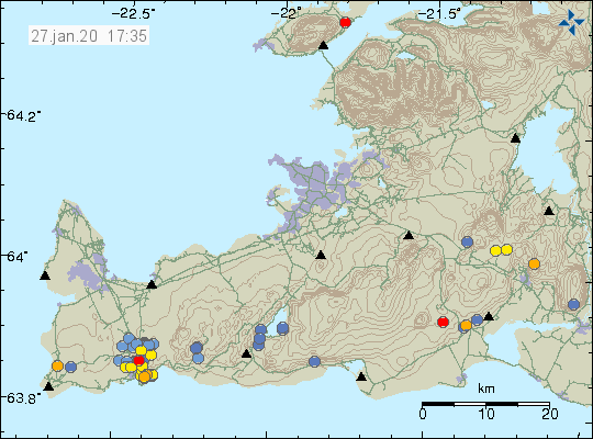
Current activity in Þorbjörn and nearby area. Copyright of this image belongs to Icelandic Met Office.
I am going to continue to monitor this situation and continue to update as best I can. Since I am currently moving back to Iceland delays may happen in the days when I move (middle of February) back to Iceland.
Donations
Please remember to support my work with donations. Thanks for the support. 🙂
