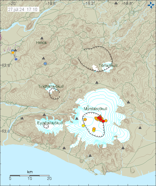
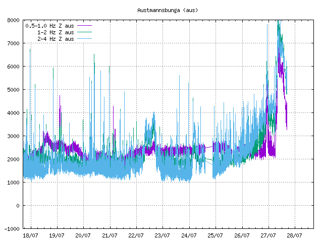
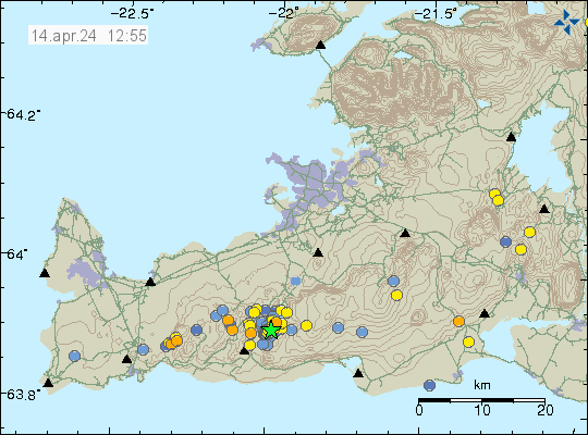
Starting sometimes late yesterday (26-July 2024), a small eruption seems to have started in Katla volcano. At the writing of this article, the eruption seems to be over, but it might restart at any time without warning, it is impossible to know at the moment, since harmonic tremor is unclear for now because of the glacier flood. Largest earthquake at the writing of this article had magnitude of Mw2,9.
Earthquake activity in Katla volcano. Copyright of this image belongs to Icelandic Met Office.The harmonic tremor in Austmannsbunga SIL station. Copyright of this image belongs to Icelandic Met Office.
Glacier flood is ongoing and is going to be ongoing for next few hours. The area around Mýrdalsjökull glacier is dangerous because of this.
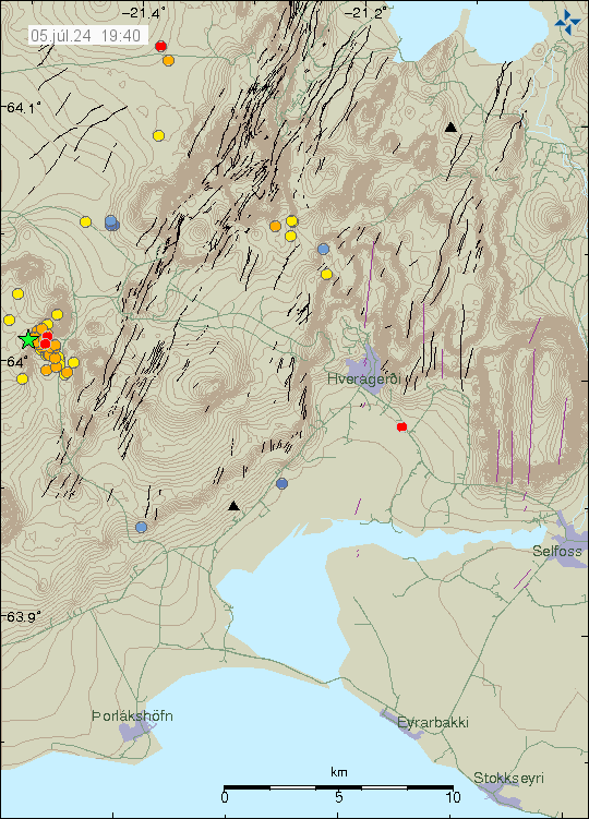
Today (5-July 2024) an earthquake swarm started in Brennisteinsfjöll volcano. Largest earthquake had a magnitude of Mw3,1 at 07:17 UTC. This earthquake was felt in Reykjavík and nearby areas.
Earthquake activity in Brennisteinsfjöll volcano. Copyright of this image belongs to Icelandic Met Office.
At the writing of this article, the earthquake swarm seems to have stopped. It might restart again, since that is common in this volcano and in this area.
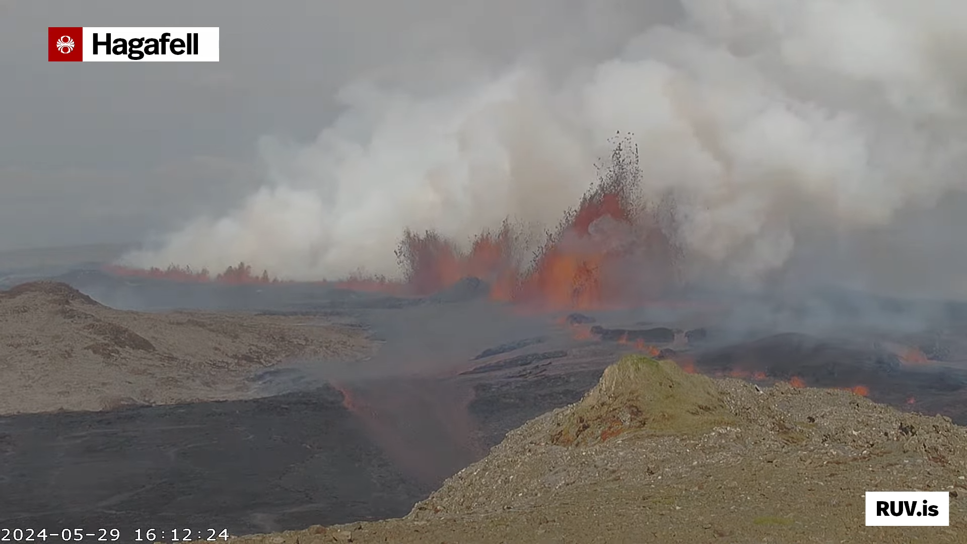
This is a short update on the eruption in Sundhnúkagígar on 30. May 2024 at 00:49 UTC. This might be the only update on this eruption, since normally, eruptions in Sundhnúkagígar only last one to three days normally. If that happens now remains to be seen.
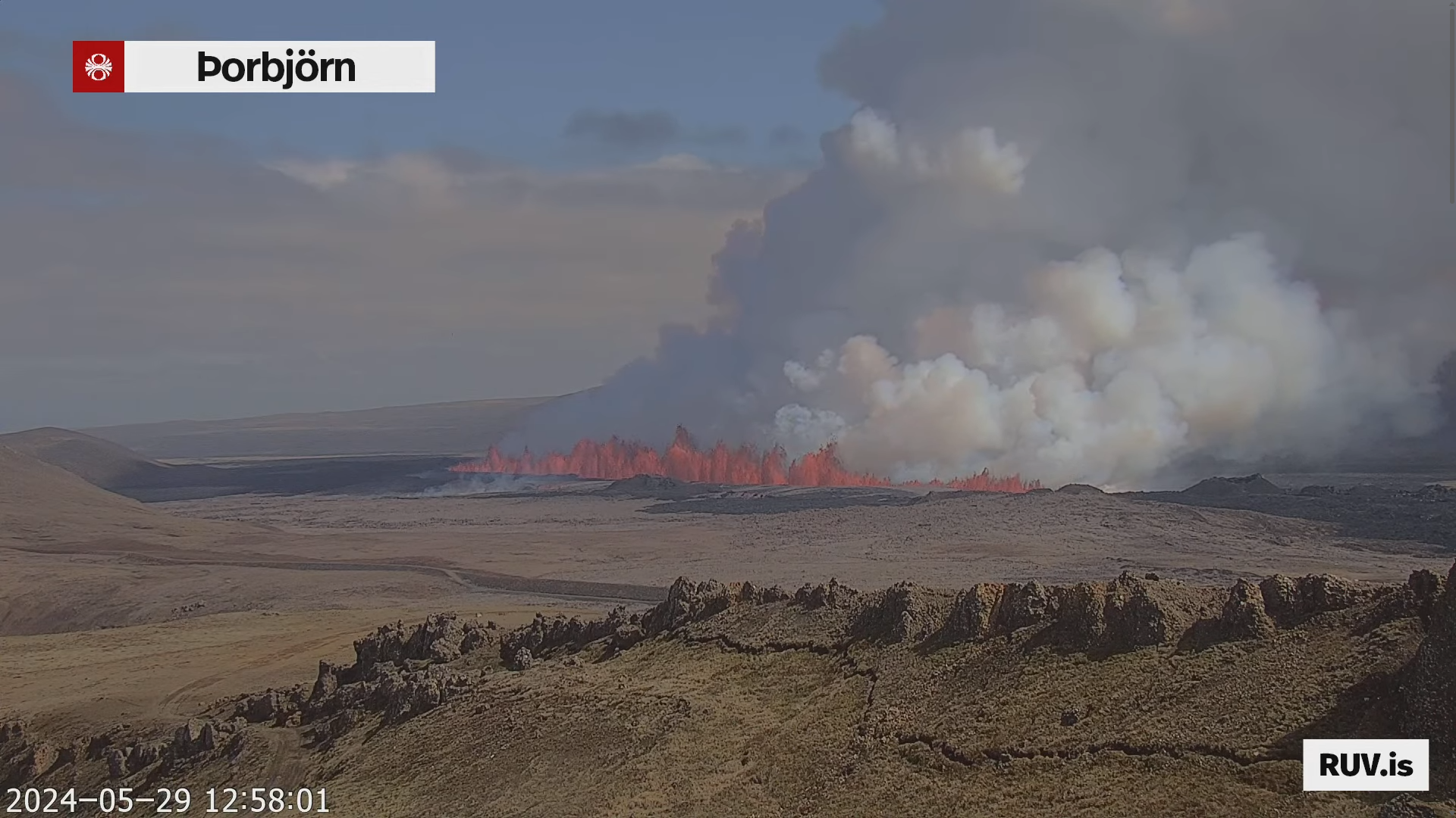
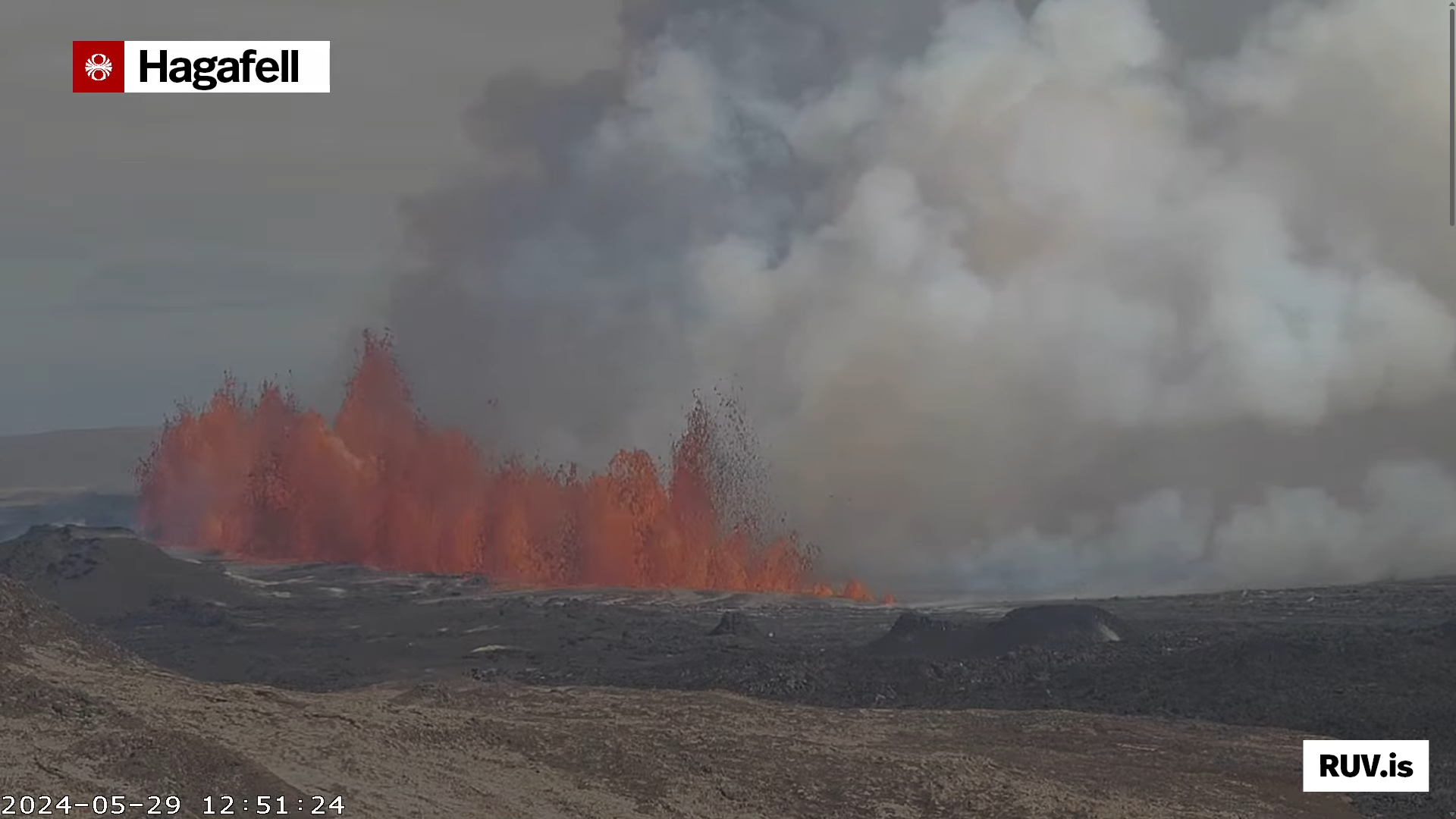
Yesterday (29. May 2024) at 12:46 UTC an eruption started in Sundhnúkagígar, close to a small mountain called Sýlingafell and other nearby mountains. This is also the same area that has had eruptions in recent months. This eruption was large and peaked at 2000m3/sec. Since then it has slowed down and is maybe only around 200m3/sec to 600m3/sec for now. The flow from the eruption is going to change without warning and quickly. The eruption fissure today was at the longest around 4 km long. Currently, at the writing of this article, the eruption fissure is around 1 to 2,5 km long. How long the fissure is going to change without warning.
The eruption just as it had started. Picture from Rúv web camera.The eruption as it was starting. The picture is from Rúv web camera.The eruption at the start. Screenshot from Rúv web camera.The most active hour in the eruption. Screenshot from Rúv web camera.
Eruption started in Sundhnúkagígar area í Svartsengi volcano. The start of eruption seems to have been at 12:47 UTC or around that minute. The fissure is getting longer as this article is being written.
The eruption in Sundhnúkagígar. Screenshot from Rúv web camera.
Eruption is about to start in Svartsengi volcano in Sundhnúkagígar area. This is unlikely to be a dyke intrusion event only. I’ll post update once the eruption has started.
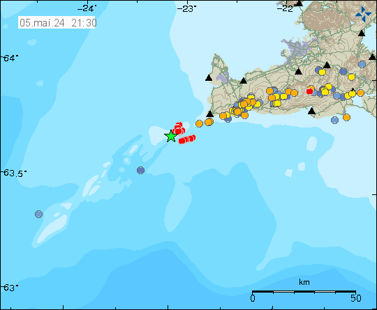
Today (5-May 2024) at 20:33 UTC an earthquake with magnitude of Mw3,5 took place close to Eldey on the Reykjanes ridge. This is out in the ocean and considerable distance from land, so more earthquakes are happening then are being registered by Icelandic Met Office.
Earthquake swarm in the Eldey volcano. Copyright of this image belongs to Icelandic Met Office.
This earthquake swarm is ongoing at the writing of this article. There are earthquakes that are only going to appear on Icelandic Met Office website after manual review in this earthquake swarm.
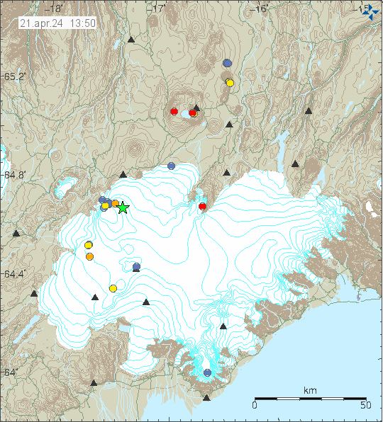
Today (22. April 2024) at 04:53 UTC an earthquake swarm started in Reykjanes volcano. This was not a strong or a large earthquake swarm. Largest earthquake only having a magnitude of Mw3,1. All other earthquakes where smaller in magnitude.
Earthquake activity on the Reykjanes ridge and in Reykjanes volcano. Copyright of this image belongs to Icelandic Met Office.
This earthquake activity suggest a magma movement. It is however too little to start an eruption at the writing of this article. That can change without warning. Since the condition that the Reykjanes volcano is in is unclear, since its in part under the ocean and that makes monitoring it properly difficult and impossible in some areas.
This morning on 21. April 2024 at 06:37 UTC an earthquake with magnitude of Mw5,4 took place in Bárðarbunga volcano. Largest aftershock had a magnitude of Mw3,0. There’s no earthquake swarm going on at the time of writing of this article. This earthquake was felt in some parts of Iceland but was possibly detected over most of Iceland in a quiet locations.
Earthquake activity in Bárðarbunga volcano. Copyright of this image belongs to Icelandic Met Office.
This is the strongest earthquake in Bárðarbunga volcano since the eruption in Holuhraun in the year 2014 to 2015. This earthquake activity is a long term signal that inflation in Bárðarbunga volcano has reached a new level. Eruption is not going to happen or is extremely unlikely to happen following this earthquake or in next few years. Shortest time between eruptions in Bárðarbunga volcano is around 10 years.
This is how I recorded the earthquake on my own seismometer.
The magnitude Mw5,4 earthquake as it was recorded on my own seismometer.
I am sorry how late I am with this article. I was busy yesterday (13. April 2024) and I was unable to write this article at that time.
Yesterday (13. April 2024) at 10:02 UTC an earthquake with a magnitude of Mw3,3 took place just south of Kleifarvatn lake in Krýsuvík volcano. This earthquake swarm seems to have happened on a fault that is mostly known for earthquakes that are connected to tectonic movements in the area. This is not a fault that is connected to volcano related activity, as those are more in south-west and north-east direction. Faults that are connected to crust movement in this area have the direction north-south as seems to be the case this time. It complicates matter that magma movement deep in the crust can result in earthquakes happening on both type of faults. As I suspect what happened here.
Earthquake activity in Krýsuvík volcano. Copyright of this image belongs to Icelandic Met Office.
Krýsuvík volcano is not ready to start an eruption, best I can see. It is also missing a lot more earthquake activity before an eruption starts. But the signs that it is moving in that direction have started to appear. How long the wait is going to be when a eruption starts is impossible to know.
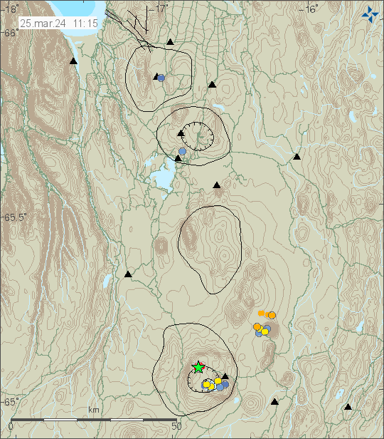
Today (25. March 2024) starting at 08:06 UTC and ending around 11:00 UTC an earthquake swarm started in Askja volcano. The largest earthquake in this swarm had a magnitude of Mw3,5. The area is remote and this earthquake was not felt.
Green star in Askja volcano. Copyright of this image belongs to Icelandic Met Office.
This earthquake activity suggests that this was a dyke intrusion. Eruption is unlikely at the moment in Askja volcano. This activity might be the first indicators that Askja volcano has started to prepare for an eruption in the future. When is impossible to know.
Cookie acceptance
We use cookies on our website to give you the most relevant experience by remembering your preferences and repeat visits. By clicking “Accept”, you consent to the use of ALL the cookies.
This website uses cookies to improve your experience while you navigate through the website. Out of these cookies, the cookies that are categorized as necessary are stored on your browser as they are essential for the working of basic functionalities of the website. We also use third-party cookies that help us analyze and understand how you use this website. These cookies will be stored in your browser only with your consent. You also have the option to opt-out of these cookies. But opting out of some of these cookies may have an effect on your browsing experience.
Necessary cookies are absolutely essential for the website to function properly. This category only includes cookies that ensures basic functionalities and security features of the website. These cookies do not store any personal information.
Functional cookies help to perform certain functionalities like sharing the content of the website on social media platforms, collect feedbacks, and other third-party features.
Performance cookies are used to understand and analyze the key performance indexes of the website which helps in delivering a better user experience for the visitors.
Analytical cookies are used to understand how visitors interact with the website. These cookies help provide information on metrics the number of visitors, bounce rate, traffic source, etc.
Advertisement cookies are used to provide visitors with relevant ads and marketing campaigns. These cookies track visitors across websites and collect information to provide customized ads.