Update on Katla volcano earthquake swarm

There has not a lot changed in the past few hours since the earthquake swarm did start in Katla volcano. Eruption has not yet started in Katla volcano and when it might start is still a mistery.

Current map of the earthquake activity.
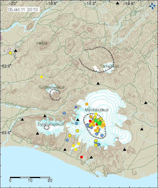

Current earthquake activity in Katla volcano. Copyright of this picture belongs to Iceland Met Office.

Here are traces from my Heklubyggð geophone. But that is currently the geophone that I have that is closest to Katla volcano. I am collecting donations so I can buy two new geophones. The blog post about that can be found here. I do not expect to have the geophone in place before a eruption starts in Katla volcano this time around. So far the donations are up too 5,410.74 DKK, so I am not far from what I need to collect. I do not have to pay customs of this according to a email I got from the customs office when I did ask about it. But I have too pay 25,5% VAT on this when it gets here. That might be a good amount I think in Icelandic Kronas (ISK).


One of the large earthquakes. This is not the strongest earthquake in the earthquake swarm that took place this morning in Katla volcano. This is also a double earthquake, that is two earthquakes taking place at the almost the same time. That is the reason for the odd looking wave form on this earthquake trace. This picture is released under Creative Commons licence. See Licence web page for more details.
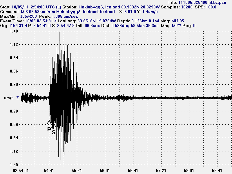

A ML3.0 earthquake that took place in Katla volcano this morning. This picture is released under Creative Commons licence. See Licence web page for more details.
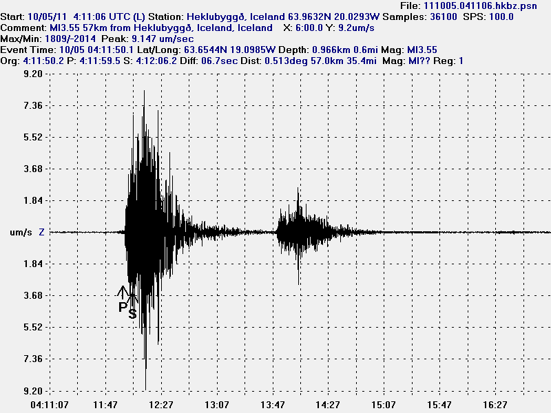

The largest earthquake in the earthquake swarm this morning. Its size was ML3.55 with the depth just short of 1 km. This picture is released under Creative Commons licence. See Licence web page for more details.


A ML2.94 earthquake in Katla volcano this morning. This picture is released under Creative Commons licence. See Licence web page for more details.

So far it has quieted down in Katla volcano. But that does not mean a lot. As magma can go on the move at any time. Without any warning at all. So monitoring Katla volcano is important with that fact in mind. According to Iceland Met Office, this is the largest earthquake swarm in Katla volcano caldera since the year 2002.

I am expecting more strong earthquakes to take place in Katla volcano. But it is impossible to know when a new earthquake swarm might start in Katla volcano and how large and long it is going to last. For the moment, it is just wait and see.

Iceland Met Office has put up a news about this in English. Thanks too the readers how pointed this out!

Earthquake activity in Katla volcano October 2011

Icelandic News about this earthquake swarm.

Snarpasta hrinan í Kötlu frá 2002 (Rúv.is, Icelandic)
Snörp hrina í Mýrdalsjökli í nótt (Rúv.is, Icelandic)
Snörp hrina í Kötlu (Vísir.is, Icelandic)
Sterkir skjálftar undir Mýrdalsjökli (mbl.is, Icelandic)
Um 20 skjálftar yfir 2 stig (mbl.is, Icelandic)

Magma on the move in El Hierro, Canary Islands

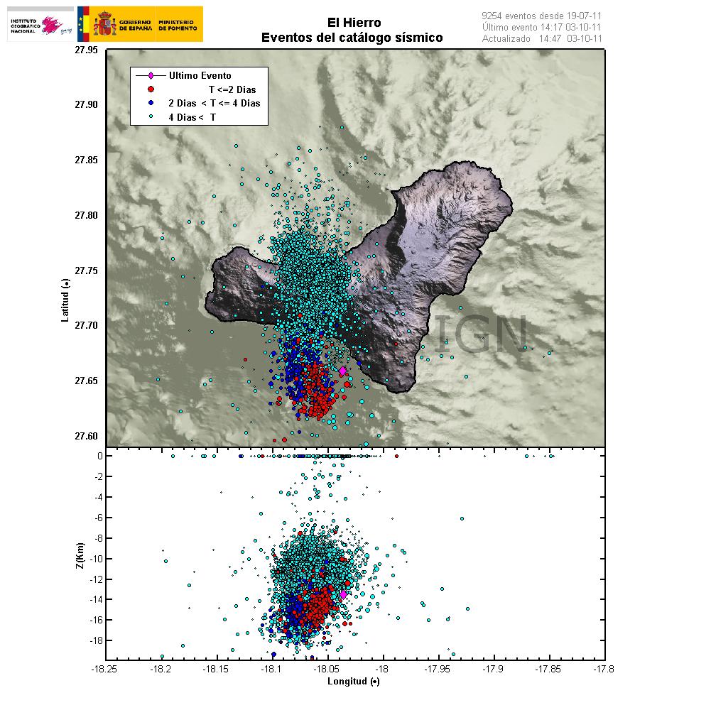
This is happening faster then I expected. But it seems that magma is now on the move upwards in El Hierro volcano in Canary Islands. This is evident by the earthquake patterns that are emerging from the volcano. Given the earthquake locations, most likely place for a eruption to take place is out on the ocean based on that. But sometimes magma can find different pathways up the surface without a lot of warning.


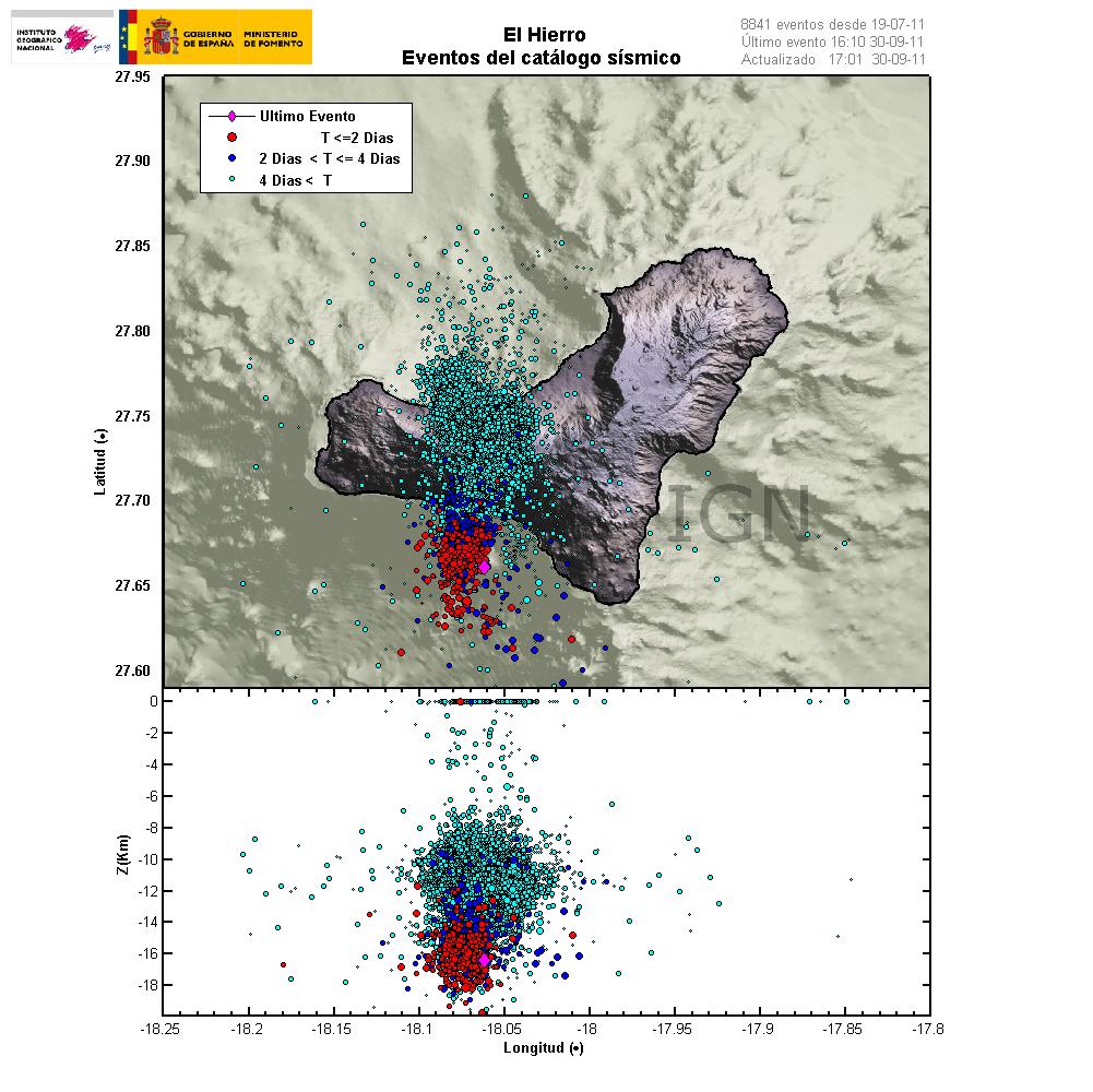
Latest earthquake map from Instituto Geográfico Nacional that shows clearly the earthquake pattern since the dike intrusion did start in El Hierro. Copyright of this picture belongs to Instituto Geográfico Nacional.

At the moment it is impossible to know when and where a eruption might start. It depends on many factors. But it is now clear that magma is on the move upwards. So far the magma seems to be around 10 km up in the earth crust under El Hierro. So it is clear that the magma is on the way up and most likely preparing for a eruption.

What is happening in El Hierro volcano

This is a special blog post about the volcano El Hierro in the Canary Islands. The resons for this blog posts are those that this activity is interesting and there is not a lot happening at the moment in Iceland due to bad weather (nothing gets recorded in this bad weather).

Currently El Hierro volcano is a phase that I personally call a magma intrusion phase (I have no other word for it). But that means that magma is currently coming from a depth, that is more then 20 km below the volcano and up the crust directly below the volcano. It is impossible to know how long this phase is going to last. As a example this phase for Eyjafjallajökull volcano lasted for good part of 17 years (with some breaks). When the pressure is high enough in the sill that is now forming in El Hierro the magma is going to break up the surface.

This pattern can clearly be seen on this image here.


The magma is flowing up into the volcano at around 30 degree angle from the depth of more then 20 km. When a new magma injection starts, a new earthquake swarm starts in El Hierro. This magma injections are different in size and length. But as more magma collects into the bedrock in El Hierro the stronger earthquakes are going to take place. But this increases the pressure on the rock and inside the magma chamber that is now forming and can clearly been seen with the earthquake pattern. Copyright of this picture belongs to Instituto Geográfico Nacional.

I did see a picture that was made on Eruptions blog that did show his clearly, both the feeder channel of the magma and the magma chamber that is currently in the making. It seems that magma inflow into the new magma chamber or the sill in El Hierro is stable at the moment. But I base that view on the constant earthquakes that are currently taking place. But this magma inflow seems to have been stable since 16 July, 2011 when the magma started to push upwards into El Hierro.

Earthquakes that signal new inflow of magma do not need to be strong in size. But they are deep, with the most depth around 20 km. But the crust in this area is around 10 to 26 km thick. As this is a ocean crust in this area. But the Canary islands are the thickest crustal part in the area. But it is also important to notice that the magma chamber or the sill is expanding in all directions, not just upwards. That in it self is also going to create deep earthquakes. But those earthquakes should remain a bit outside the main area of the deep earthquakes that are currently taking place in the area.

I am expecting a lot more earthquake activity when or if El Hierro starts erupting. But when that might happen impossible to know for the moment. The only thing that can be done is too wait and see what happens.

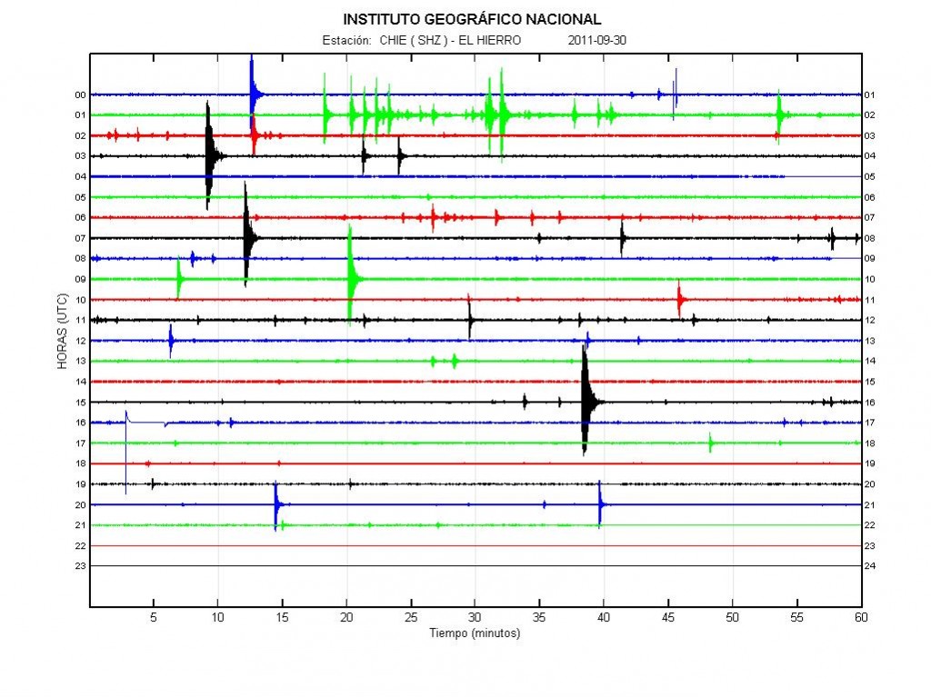
Update 1: Here is the earthquake activity for today (30 September, 2011).


Earthquake activity of today (30 September, 2011). There is less earthquake activity today. This happens when magma flows into a volcano. This did also happen with Eyjafjallajökull volcano in the year 2010. If anyone has the direct link too this plot, please leave it in the comments. Thanks. Copyright of this picture belongs to Instituto Geográfico Nacional.

Update 2: Links too El Hierro information can be found here.

Update 3: The Spanish news channel Canal 24 can be found here and it is live.

Update 4: Here is a news in english about the evacuation of El Hierro. It is from 28 September, 2011. Evacuation of El Hierro begins as fears of volcanic eruption grow. Thanks to Dr. John v. Kampen that did send this to me with a email.

Note: There are new pictures of Eyjafjallajökull volcano, Fimmvörðuháls craters here. They show the difference from the year 2010 and in the year 2011. The text is in Icelandic.

Also. Please support my effort so I can buy two new geophones and add them to my monitoring network in Iceland. Thanks! 🙂

Blog post has been updated 30 September, 2011 at 22:12 UTC.
Blog post has been updated 30 September, 2011 at 22:25 UTC.
Blog post has been updated 30 September, 2011 at 23:08 UTC.
Blog post has been updated 1 October, 2011 at 14:48 UTC.

New earthquake swarm in Katla volcano

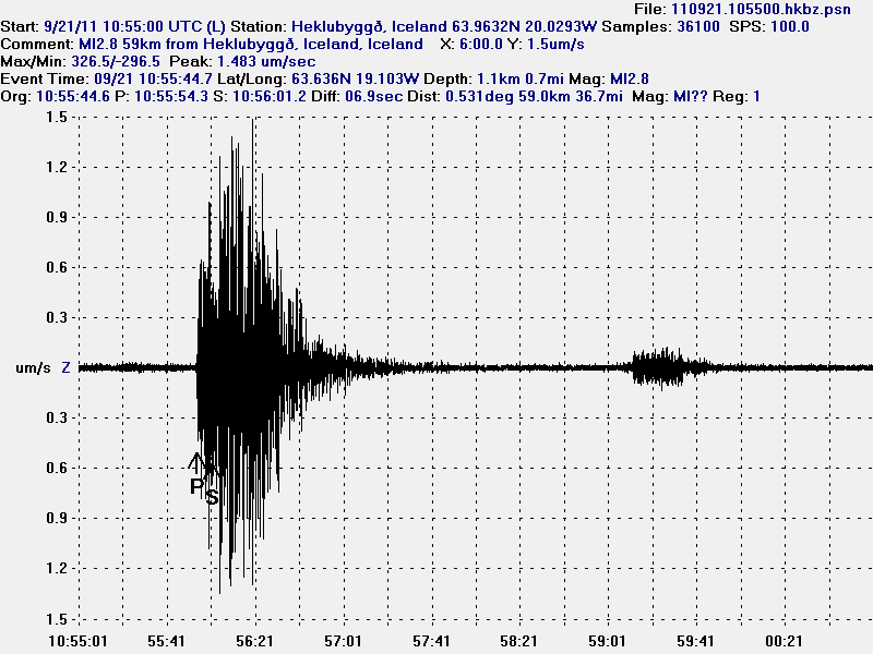
After few quiet days in Katla volcano. It seems that new earthquake swarm is about to start in it. But this earthquake swarm did start with a ML2.8 earthquake (automatic size) at 10:55 UTC. This earthquake have been followed by smaller earthquakes. So far there have not been many earthquakes in this earthquake swarm. But the largest earthquake took place on what I think is the fissure where the eruption in the year 1918 took place.


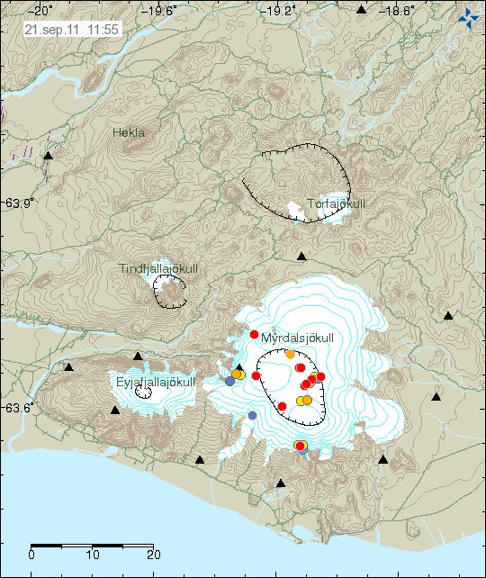
The earthquake swarm can be seen here. Copyright of this picture belongs to Iceland Met Office.

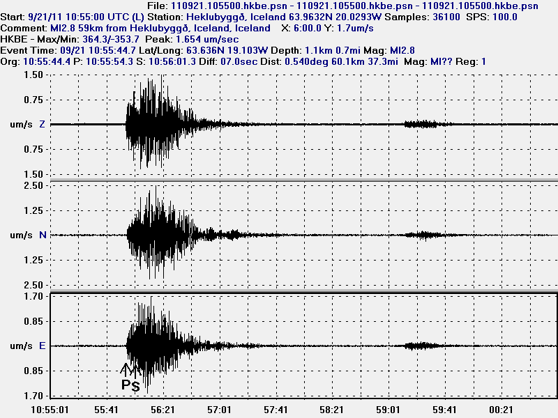
The largest earthquake clearly has magma signature in my opinion. As it can be seen on my geophone recording of this earthquake.


The ML2.8 earthquake. This picture is released under Creative Commons Licence. Please see licence web page for more details.


High resolution of the Katla volcano ML2.8 earthquake. The bump later on this earthquake trace is the second earthquake that only had the size ML0.9 according to the automatic size estimate. This picture is released under Creative Commons Licence. Please see licence web page for more details.

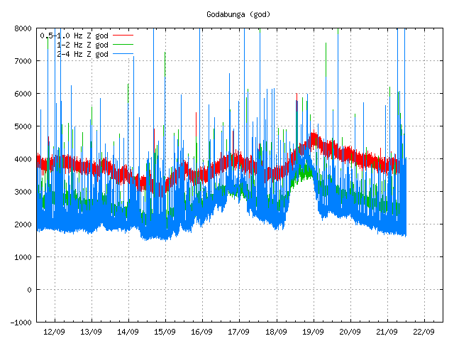
There seems to have been some type of tremor event on Goðabunga SIL station just before the earthquake. I am not sure what event this was. But it does not appear on other SIL stations around Katla volcano.


Goðabunga SIL station. Copyright of this picture belongs to Iceland Met Office.

For the moment the only thing that can be done is to wait and see what happens in Katla volcano.

Inflation starts in Katla volcano

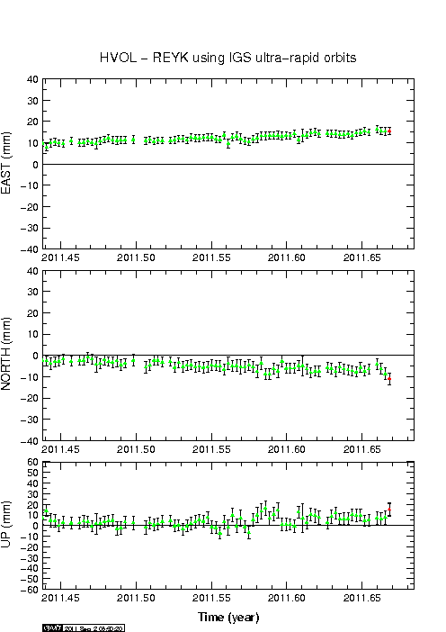
There seems to be inflation going on in Katla volcano, at least according to the automatic GPS data that IMO has on it’s web site. But this might be error in the data. But for the moment I do not think it is. But please do look at this data with the view that it might be wrong.


The inflation appears clearly on Lágu Hvolar GPS station. Copyright of this image belongs to Iceland Met Office.

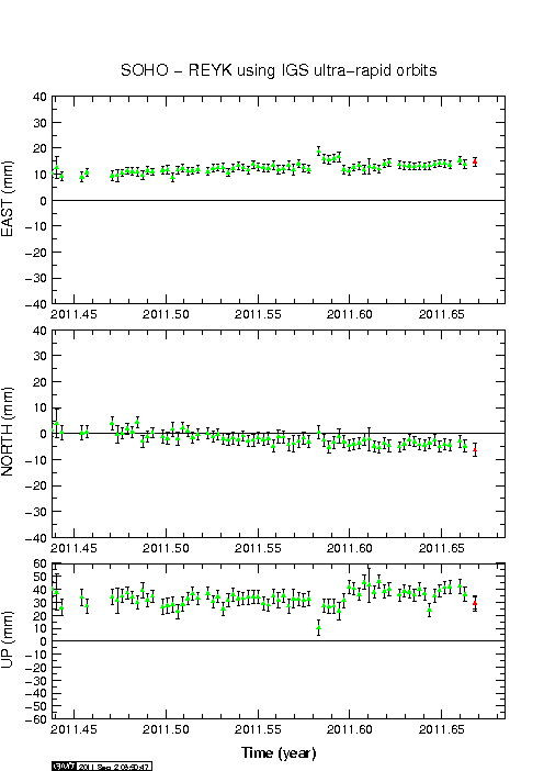
The inflation can be seen on Lágu Hvolar and Sólheimaheiði GPS stations. But it appears to be more clear at HVOL GPS station. But that is most likey because that GPS station is closer to the magma pocket in question that creates this movement.


The inflation also appears on Sólheimaheiði GPS station. But not as clearly as on Lágu Hvolar GPS station. Copyright of this image belongs to Iceland Met Office.

What might be the critical inflation before a eruption starts is hard to know until it happens. For Eyjafjallajökull volcano that was 60mm, for Grímsfjall volcano the inflation was actually 350mm. But that volcano had eruptions that did not change it’s inflation numbers. I do not know why Grímsfjall volcano is so different in this respect from other volcanoes in Iceland (that I know of so far).

Grímsfjall volcano inflates after the large May 2011 eruption

It can be sad that Grímsfjall volcano did not waste any time starting to prepare for next eruption after the large May 2011 eruption. But that eruption was the largest one in at least 140 years or so. This large eruption did mean that there was a large deflation that took place during the eruption. Where the most deflation was around 250mm down, and around 300mm north, and around 350mm east.

Since then Grímsfjall volcano has however been inflating at interestingly high speed. Currently the GPS data shows that it has reached around 250mm east, north and 200mm up since the eruption. But the magma chamber is going to expand horizontal before it expands upwards (think of this in 3D). So it is going to be a while until a inflation upwards is going to be seen.

The GPS data is clear on this as can bee seen here.


Current inflation at 27. July 2011. Copyright of this picture belongs to Icelandic Met Office.

It is hard to know when Grímsfjall volcano is going to erupt next after this big eruption. But it might take few years until we see a new eruption in Grímsfjall volcano.

Update on Hekla volcano status

Here is an update on Hekla volcano. First of, for the moment the inflation in Hekla volcano is deflating at the moment. This is following the same pattern as before last time this did happen. But that does not mean this might not happen again soon. For the moment, nobody knows what exactly is going on inside Hekla volcano as there are no earthquakes following this inflation period. The magma that is on the move down there is most likely moving deep down in the crust also, as Hekla volcano does not have shallow magma system that I know of (or is known of anyway).

What did happen inside Hekla volcano was most likely an dike intrusion somewhere in the volcano system. This dike intrusion did not create any earthquakes, that suggests to me that it was travelling trough an old dike system already in place inside Hekla volcano system. This is most likely to happen again in Hekla volcano, if that starts an eruption is hard to know for sure.

In regards to possible ash cloud from eruption in Hekla volcano is impossible of know for sure now what happens in next eruption. There might be an ash cloud, but then again there might not be. All that can be done is to wait and see what happens in the next days, weeks or years.


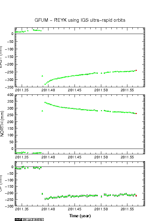
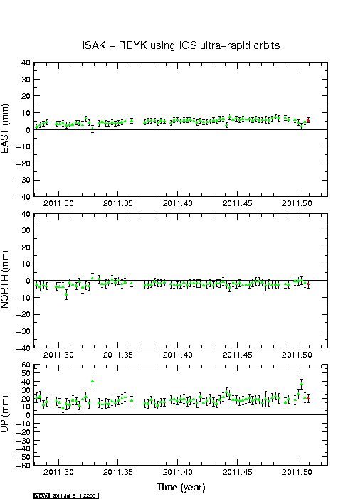
The GPS movement of Hekla volcano. The inflation and the deflation can clearly be marked here. There is an inflation spike around 2011.45 on this plot. But this did also happen in April/May I think (but it might be wrong). Daily updated chart can be found here. Copyright of this picture belongs to Icelandic Met Office.

It is also important to notice that Civil Emergency Authority (Almannavarnir) in Iceland advice against it travelling up to Hekla volcano at current time. Since an eruption can start in Hekla volcano without any warning at all and the maximum time that people have evacuate the mountain is from 1 hour and up to 1 hour and 30 min. No more then that. Being on top of Hekla volcano when an eruption starts is deadly to everyone. If you want to go up to Hekla volcano. Please let somebody know about and have an fully charged mobile phone with you at all times. As the Civil Emergency Authority send out an SMS message to all mobile phones in the area around Hekla volcano if an eruption is starting (I think they do that).

Icelandic News.

Almannavarnir: Hekla tilbúin í gos (Rúv.is, Icelandic)
Almannavarnir vara fólk við Heklu (Vísir.is, Icelandic)

Magma movements under Hekla volcano have been confirmed

According to the news on Rúv the GPS movements that many have been seeing around Hekla volcano in the past few days are real. At the moment the civil disaster authorities have been notified and also local emergency authorities. Nobody seems to know what is going on with this magma moments for the moment. But they can be tracked with the GPS network to some extent. What is more interesting is that this does not seems to have started until few days ago. But first signals of this happening did take place in April and May, but at lot smaller scale. What is interesting is that fact that no earthquakes appear during this magma movements, there is also no harmonic tremor when the magma is moving around in the crust close to Hekla volcano. But if there is any earthquakes, noise or whatever coming from Hekla volcano it is going to appear on my geophone that is located about 16 km away from peak of Hekla volcano. The distance is even less from the actual edge of the Hekla volcano system it self.

Normally, there are no changes in the GPS network before an eruption in Hekla volcano. So this is highly unusual event in Hekla volcano since instrumental monitoring started few decades ago.

It is an question if this means an fissure style of eruption is going to take place in Hekla volcano. But that does sometimes happen, as with any volcano in Iceland. For the moment however the only thing that can be done is wait and speculate (within reason).

No eruption has started in Hekla volcano. But it can be assured that it might start without any warning and I might not be around the computer when that start, since I am working during the day and feeling tiered during the evening. But I am getting slightly better on that front, thankfully.

I am going to post more on this when I do know more, or if anything happens in Hekla volcano related to this.

Icelandic News about this.

Hræringar í Heklu (Rúv.is, Icelandic)

Eruption in Grímsfjall volcano is over

According to the news at mbl.is the eruption in Grímsfjall volcano did end at 07:00 UTC on the 28. May 2011. But that was when the last harmonic tremor was seen on Icelandic Met Office SIL stations.

There is an lot of volcano as in the area around Grímsfjall volcano. That means it is going to blow easy with the wind in the dry summer.

According to GPS data from Icelandic Met Office. It seems that inflation has started at Grímsfjall volcano again. But it can be assumed that it is going to take several years until next eruption. But if that is going happen we just have too see.

Morgunblaðið news about the end of the eruption.

Goslokin sett klukkan 7 á laugardag (mbl.is, Icelandic)
Grímsvatnagosinu lokið (mbl.is, Icelandic)
Gosinu lokið (Rúv.is, Icelandic)

Eruption in Grímsvötn appears to be over (hopefully correct this time around)

It appears that the eruption in Grímsvötn / Grímsfjall volcano is over or is about to end, but authorities in Iceland might not declare the eruption over until after next weekend. No ash plume has been observed for over 24 hours now from Grímsfjall volcano. Harmonic tremor pulses are still taking place in Grímsfjall volcano and it is still dangerous to get close to the eruption site. As explosion still take place in the eruption area and that makes going there dangerous. It is not only the area where the water is that is having explosions. There are also gas and explosions taking place in the crater rims and nearby area. According to news today Icelandic Met Office did stop recoding the eruption in Grímsfjall volcano around 07:00 UTC this morning (28. May 2011). But harmonic tremor pluses might still be taking place in Grímsfjall volcano. But the SIL stations around Grímsfjall volcano have now started to record background noise again, including the SIL station at Grímsfjall volcano.

Earthquake activity has continued at similar levels as before the eruption took place. I am not sure why that is. But this might indicate that Grímsfjall volcano has already started to prepare it’s next eruption. But when that might happen is a question that only time is going to answer. The main earthquake activity is currently taking place NW of Grímsfjall volcano, and SW of Grímsfjall volcano.

According to automatic GPS data it appears that Grímsfjall volcano has started to inflate again. This inflation appears to be rather rapid at current moment. But it appears to be close to 1mm/day inflation to the south and east. This means that new magma has already started to flow into Grímsfjall volcano magma chamber and magma system from greater depth. So far Grímsfjall volcano has not started to inflate upwards and it might be an while until that happens, as there might be enough space for the magma to move into inside Grímsfjall volcano.

Measurements of the volcano tephra that did fall, along with measurement of the volcano ash that did fall have recorded the depth up to 170 cm in some areas of Vatnajökull glacier even at distance of 8 km from the eruption site. This is going to create problem in the summer when it is dry and the wind blows this volcano ash around Iceland. But mostly in the areas that where closest to the main ash fall areas.

Update 1: According to news on Vísir.is the Icelandic Coast Guard did see an plume with the hight of 1,5 km yesterday. This plume was however mostly made out of steam rather then volcano ash. The news about this can be found here, along with an picture of the plume. Here is an second news of this steam plume that was seen yesterday.

Update 2: According to news on Rúv there is small harmonic tremor being recorded. But most of the time, no harmonic tremors are being detected from Grímsfjall volcano. The Rúv news can be found here (Icelandic, Picture). It also has an new picture of the eruption crater. But this picture was taken around 10:00 UTC today (28. May 2011).

Icelandic News about this. Use Google translate on this for an risky translation.

Eldgosið mælist ekki lengur á jarðskjálftamælum (Vísir.is, Icelandic)
Enginn gosmökkur í dag (From 27. May 2011, Rúv.is, Icelandic)

Blog post updated at 19:11 UTC.
Blog post updated at 20:15 UTC.