Update on Askja and Bárðarbunga volcanoes at 22:21 UTC

This is a short update on Askja and Bárðarbunga volcanoes. This information is going to get outdated quickly. I am not going to use pictures from now on (in most cases), since the situation now is complex and is going to go more complex as this goes on.

If you are first time commenter I need to approve your comment once. I have the comment section set-up this way in order to prevent spam getting  into the comment section. I have enabled registration and registered users don’t need to deal with the word challenge. I had to close it a while ago due to spam bot problem that were registering on my website. I also need to approve all comments that have more than three links in them.

Askja volcano

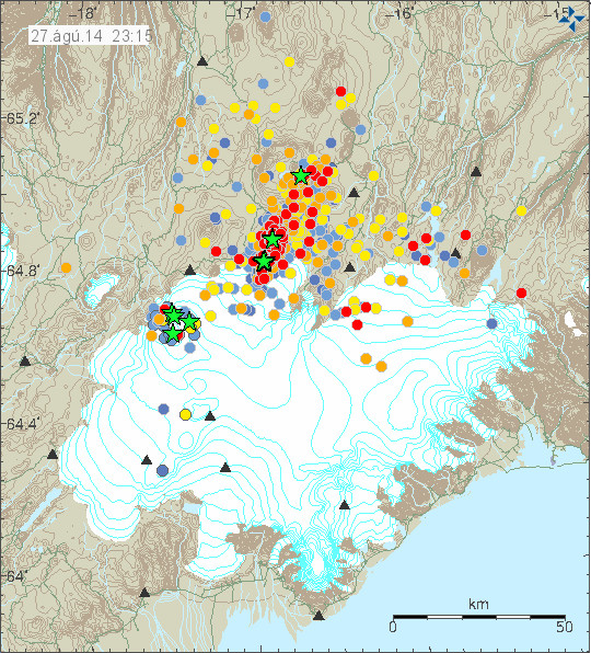
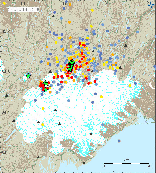
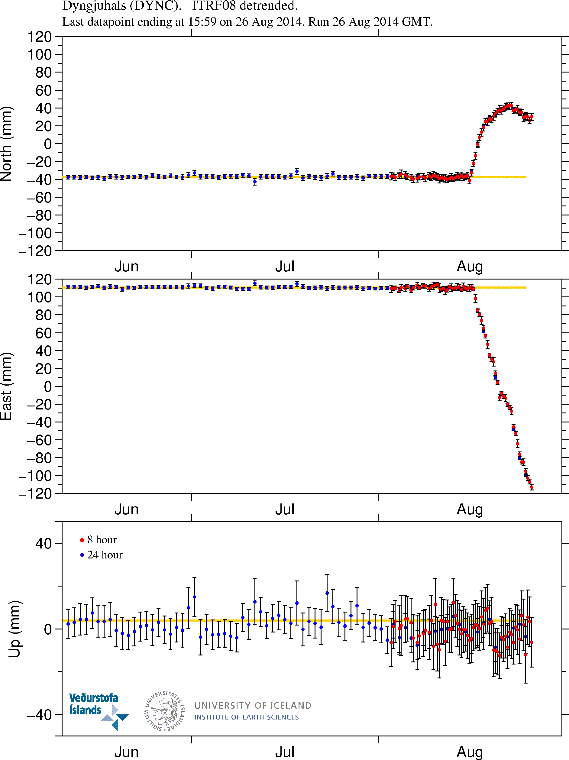
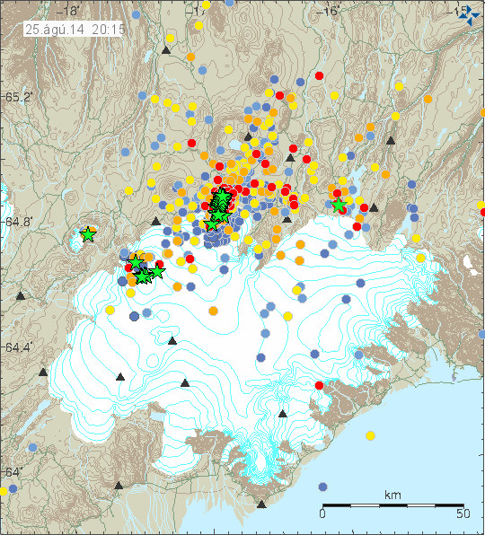
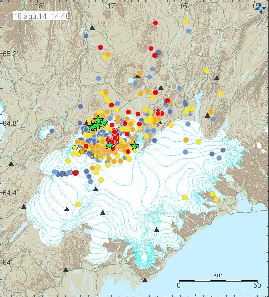
  • The dyke from Bárðarbunga volcano continues its journey into Askja. It has not yet reached Askja magma chamber. When that is going to happen is unclear at the moment.
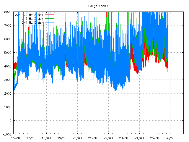
  • Activity has been picking up in Askja due to stress changed from the dyke.

 Bárðarbunga volcano

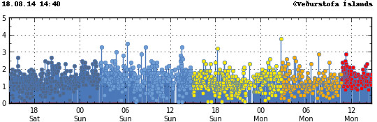
  • Dyke activity continues at similar rate as before. It is now moving about 1 – 2 km a day according to latest news. The dyke has reached Askja volcano main system, it has not reached Askja main magma chamber. Once that is breached earthquake activity along with harmonic tremor in Askja is going to trough the roof.
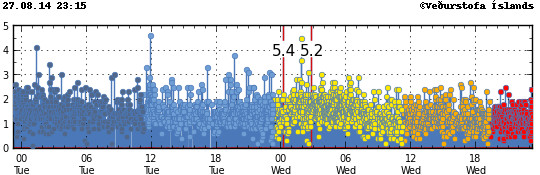
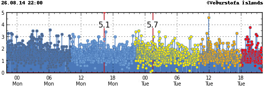
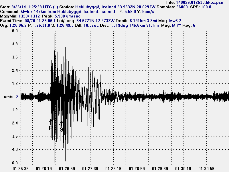
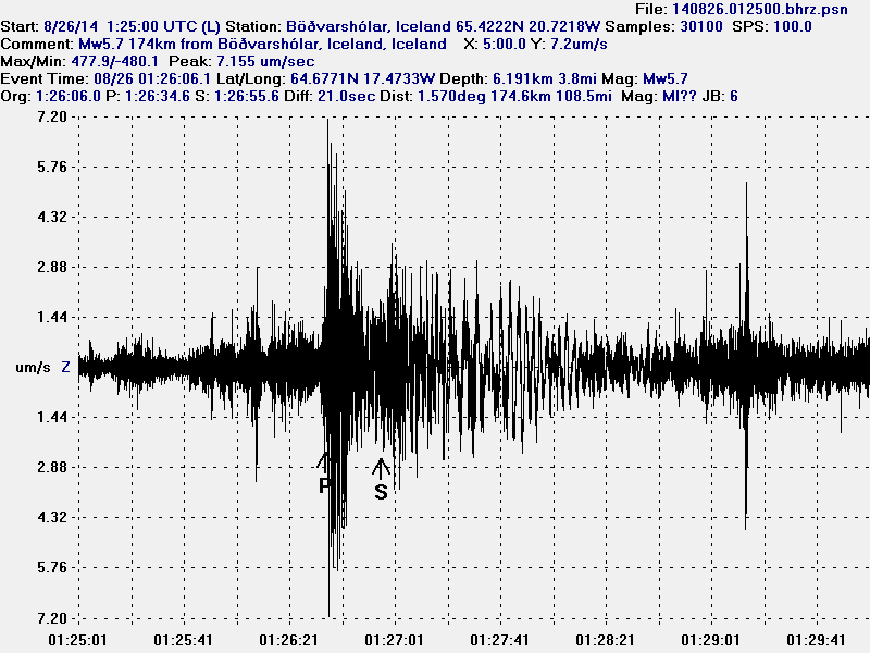
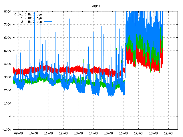
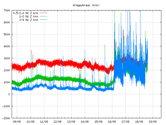
  • Eruption on 23-August-2014 has been confirmed. It only lasted for 1 – 2 hours before it died down. I think current ideas why it happened are wrong. From my perspective it happened due to magma pressure inside Bárðarbunga magma chamber reaching a high point (highest so far). This did mean that the dyke was not able to tap off the magma chamber at fast enough rate for a short while. Allowing magma to breach the crust at other locations. While this was a short event, this suggests that magma is coming into Bárðarbunga magma chamber at depth. So far the volume that is flowing in is low for the moment. I suspect that might change at any time and without any warning.
  • The reason why the ice cauldron did not appear sooner is that it took the water some time to dig its own path trough the glacier. Why it did go to Grímsvötn lake (Grímsfjall volcano) I do not knwo.
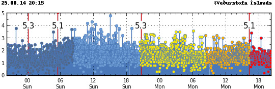
  • Earthquake activity remains high in the north end of the dyke. Earthquake activity is present in Bárðarbunga volcano (main volcano), but it is not constant at the moment. That might change without warning.
  • No dyke activity so far going south of Bárðarbunga volcano.
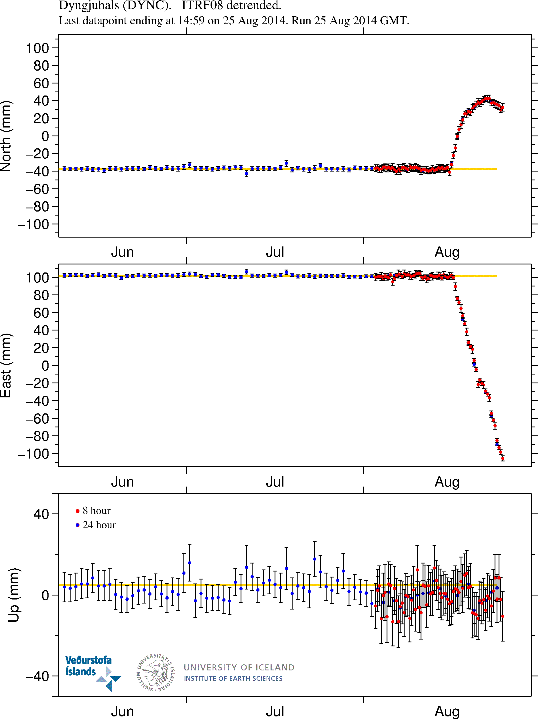
  • Cracks appearing in the crust suggest that the dyke depth is only about 2 km at most. This has also allowed for groundwater warning up in areas. This has been seen under areas were the glacier is thin. This is creating hot springs and hydrothermal areas along the dyke path.
  • Inflation so far is around 40 cm to the east and west. There is nothing to suggest it is going to slow down at the moment.
  • This might be a long eruption once it starts. How long I do not know. At most some years, as has happened in Bárðarbunga volcano in the past.
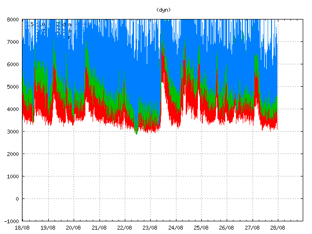
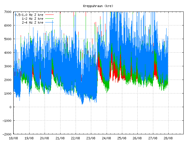
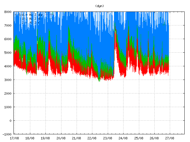
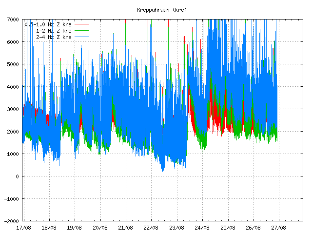
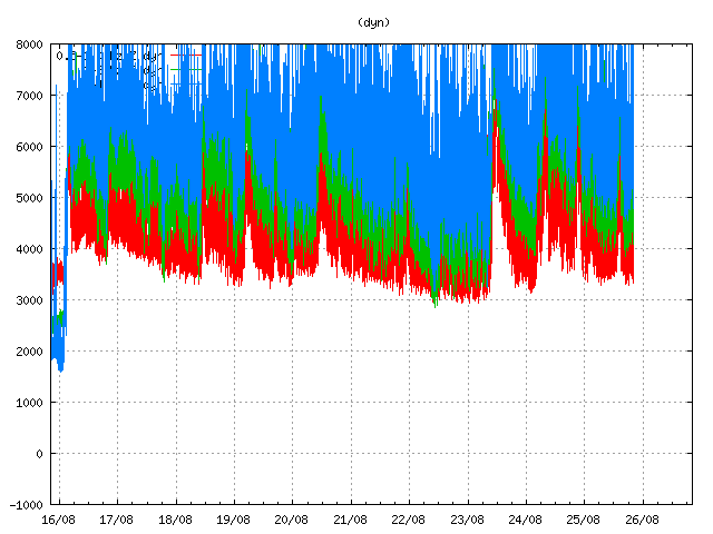
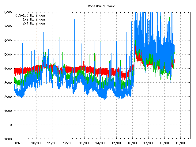
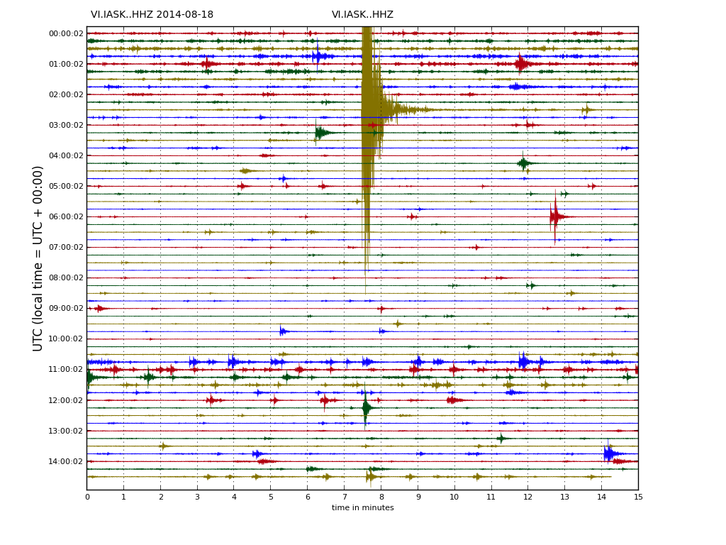
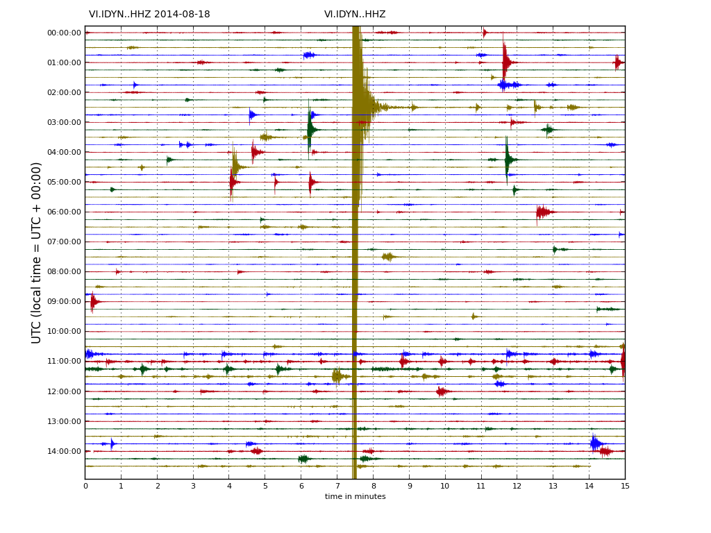
  • Today there has been minor “quiet” time in Bárðrabunga. Harmonic tremor has been stable and no cycle of up and down has taken place. In my view that might change in next hours. I am already seeing changes in the tremor plot that suggest this.

The situation is highly dynamic and is going to change rapidly at times. So this information is going to get outdated quickly for that reason. For wind, weather and earthquake information in Iceland please check Iceland Met Office website. My geophone website can be viewed here.

Article updated at 23:33 UTC.

Update on Bárðarbunga and Askja volcanoes at 13:34 UTC

This is a none picture update on Askja and Bárðarbunga volcanoes. The reason for this none picture update is that I haven’t had time to work on the images yet. This is the first time this has happened in Iceland since modern recording started. What is going to come out of this I do not know yet.

If you are in the area. Please don’t go into the closed area. There are fines for during so and it is also extremely dangerous since we don’t know properly what happens and risk of sudden flood is high and growing. Eruption might start at any time without warning, both outside the glacier and inside the glacier. If an eruption takes place in a glacier covered area, that means sudden glacier flood that are going to kill you if you are in flood path. In such glacier flood it is not just mud, volcano material, but also an ice bergs that are larger than 5 floor houses. If you get lost in such flood, the chance of being rescued from such flood are none. If you want to watch what is now unfolding do so at the save distance, this show is going to big according to my earliest estimate and guess work (not going to publish that here).

Askja volcano

  • The dyke from Bárðarbunga volcano has entered Askja volcano. Not the fissure swarm, the volcano it self.
  • Askja volcano status has been elevated to Yellow.

Bárðarbunga volcano

  • Cauldrons in Vatnajökull glacier that is on top of Bárðarbunga volcano have not grown during the night.
  • The water seems to be flowing into Grímsvötn (Grímsfjall volcano) lake. It has risen close to 15 meters in the past few days.
  • Earthquake activity is high. Both in the main volcano were a magnitude 5,4 earthquake (EMSC magnitude, USGS magnitude) took place today (28-August-2014) at 08:13 UTC. The earthquake took place in the caldera rim as most of the large earthquakes have happened.
  • Over 1300 earthquakes happened yesterday in the north end of the dyke swarm.
  • Cracks have started to happen in the crust above the dyke. This means the dyke is getting wider and is higher up in the crust then suggested by earthquake activity. There are reports of small cauldrons in Dyngjujökull glacier in the area, in the place were the glacier is thinnest and ending.
  • Harmonic tremor remains high on all SIL stations around Bárðarbunga volcano.

The situation is extremely dynamic and is going to change fast in next 24 to 48 hours. I am now close to 80% sure that an eruption is going to take place in both Askja volcano and Bárðarbunga volcano, since minor eruptions have been taking place under the glacier already.

Unclear what is happening in Bárðarbunga volcano

This information is going to get outdated extremely fast.

  • Earthquake activity remains high.
  • Cauldron have formed in Vatnajökull glacier just SE and SSE of Bárðarbunga volcano.
  • The cauldrons are 4 to 6 km long and about 1 km wide.
  • No harmonic tremor have been seen, but that might have its own reasons.


140827_2315
Earthquake activity in Bárðarbunga volcano for past 48 hours. Copyright of this image belongs to Icelandic Met Office.

140827_2315_trace
Earthquake activity remains dense in Bárðarbunga volcano for the past 48 hours. Copyright of this image belongs to Icelandic Met Office.

dyn.svd.27.08.2014.at.23.22.utc
Harmonic tremor remains high on Dyngjuháls SIL station. Copyright of this image belongs to Icelandic Met Office.

kre.svd.27.08.2014.at.23.23.utc
Harmonic tremor is also high on Kreppuhraun SIL station. Copyright of this image belongs to Icelandic Met Office.

The cauldrons that have been spotted today in Vatnajökull just SE and SSE of Bárðarbunga volcano are in the south end are of the current dyke. What is also important, they are also in an area were magnitude 5,0 earthquake did happen few days ago, in a area that has not had any dyke activity since 16-August-2014 when this all started. It is still unclear what happened to all the water in this melt, the glacier in this area is 400 to 600 meters thick and this is not a little melt that has taken place in the glacier. There is a chance the water did go to Grímsvötns lake (caldera like in Grímsfjall volcano), but that remains unclear at the moment.

I am going to post more information about this once I have them.

Updated at 00:14 UTC on 28-August-2014.

Bárðarbunga volcano update at 00:31 UTC

This information is going to get outdated quickly.

This is the short update on status on the activity in Bárðarbungu volcano.

  • Current activity is mostly unchanged. Earthquake activity remains high  and there are around 1000 earthquakes every 24 hours.
  • According to the news today and Icelandic Met Office data, the dyke doesn’t appear to be getting longer. It is now around 37 km long.
  • Largest earthquake since 2008 took place in Bárðarbunga volcano on 26-August-2014 at 01:26 UTC. It had the magnitude of 5,7 and took place in Bárðarbunga caldera. Second medium earthquake took place today at 11:56 UTC and had the magnitude 4,6. It was felt in Akureyri.
  • There are no signs of magma going to the surface as of writing of this article. I do expect that change quickly.
  • It is now my view that after the magnitude 5,7 earthquake the risk of an eruption Bárðarbungu caldera has increased from what it was. I don’t know yet if an such eruption is going to take place. I however find it to be the most likely outcome based on current status.

The magnitude 5,7 earthquake that took place on 26-August-2014 is the strong earthquake in Iceland since 2008, when a magnitude 6,3 earthquake happened between Selfoss town and Hveragerði in the South Seismic Zone in Iceland (often just called SISZ). Earthquake activity remains high in the north end of the dyke, with strongest earthquake today having the magnitude 4,6. With many more magnitude 3,0 and stronger earthquakes taking place. There are still over 1000 earthquakes being recorded every 24 hours in area where the dyke is located (about 20 km east of Trölladyngja).

140826_2200
Earthquake activity in Bárðarbunga volcano today. This map is already outdated. Copyright of this image belongs to Icelandic Met Office.

140826_2200_trace
Earthquake activity remains extremely dense in the dyke from Bárðarbunga volcano. Copyright of this image belongs to Icelandic Met Office.

Total lack of earthquake at the start of the dyke suggest that the flow of magma is now smooth and it is flowing without any resistance to the north end of dyke. Where the dyke seems to have hit a resistance in the crust that he is not able to break at current time. I don’t know if the earthquakes that have been taking place today are going to change that. But if this resistance in the crust holds there is a chance it there are going to be even large earthquakes that are going to take place at this location. What magnitude is to expect is difficult to know for sure, but the crust in this area is able to make earthquakes above magnitude 5,5, but how far up the scale it goes I do not know.

There has been some deep earthquake activity taking place according to the automatic data, but since it is automatic data it might be wrong. The deepest earthquake that I did see to day took place today had a automatic depth of 29,3 km with quality of 90,10. There is a chance this dyke might get into connection of other deep dyke in this area. This are dykes that form deep in the crust at depth of more then 30 km, they don’t make any earthquakes when they form since the crust material in this region of the crust is soft and is unable to break and does not make an earthquake as result. I do not know what happens if this dyke manages to connect to an dyke that might have formed in the deeper range of the earth crust in this area. It is also a highly unlikely outcome, for the moment however it is not impossible. Since the dyke now has problems pushing north, and as an result of that it seems to be pushing a little bit down as result. It is clear that once it can not extent any future down or to the sides, it is going to go up. I am not expecting the flow of magma into the dyke to drop any time soon. That might happen, it is just unlikely to happen given the current data. Estimated amount of magma is around 350 million m³ today (26-August-2014).

dyn.svd.26.08.2014.at.22.30.utc
Harmonic tremor remained high in Bárðarbunga volcano due to magma flow in the dyke. This is Dyngjuháls SIL station. Copyright of this image belongs to Icelandic Met Office.

kre.svd.26.08.2014.at.22.31.utc
Here is the harmonic tremor in Bárðarbunga on the SIL station in Kreppuhraun. Copyright of this image belongs to Icelandic Met Office.

The harmonic tremor shows that the dyke inflow continues as I did write about above. It also shows one important thing, the flow of magma into the dyke and presumably into Bárðarbunga volcano is not even. It happens in short periods of high inflow with lower periods between them.

DYNC_3mrap.svd.26.08.2014.at.22.25.utc
GPS data show the magma continues to flow into the dyke at 5 to 10 km depth. More GPS plots can be found here. Copyright of this image belongs to University of Iceland.

140826.012538.hkbz.psn
The magnitude 5,7 earthquake as it appeared on my geophone in Heklubyggð. This image is released under Creative Commons licence. See CC Licence page for more details.

140826.012500.bhrz.psn
The magnitude 5,7 earthquake as it appeared on my geophone in Böðvarshólar. This image is released under Creative Commons licence. See CC Licence page for more details.

What this has told me is that there is far more magma in Bárðarbunga volcano then appear at first sight. How much of it can actually erupt in an eruption I do not know. But this seems to be far more complicated then I first thought, it is not just a dyke pushing out of Bárðarbunga volcano. There is also a lot more magma inside the magma chamber that is starting to look for an way out, at least from the looks of current activity. The glacier inside the caldera is 700 meters thick so the magma inside the magma chamber that is directly below the caldera is under this extra pressure from the glacier. Once that magma overcomes the pressure of the glacier an eruption is going to start in the caldera, until that time we might see more dyke activity going north and south of Bárðarbunga volcano. Since the magma is going to go first the easiest way out. How much pressure has to be inside the magma chamber to overcome the pressure of the 700 meter thick glacier inside the caldera I do not know. All I know is that it is a high number on any pressure scale.

As of this writing a new magnitude 5,1 (more on EMSC website here) has taken place in Bárðarbunga volcano caldera. Larger earthquake appear clearly on my geophones that can be viewed here.

Bárðarbunga volcano update at 20:49 UTC

This information is going to get outdated quickly. Minor spelling note. It appears that dike is spelled with a simple “i” not a “y”. Information on what volcano dyke is can be found here on USGS website. Added: That is in U.S English, UK English uses Dyke so I am going to use UK English. Thanks to Squonk to pointing me to this information.

Special note on Askja volcano

There are many people speculating that the dyke might reach into Askja volcano. I find that to be unlikely outcome. That does not appear to have happen in the past and I don’t think the geology setting allows for it. The area is full of old dykes that have cooled into granite type of rock (and other hard types of rock) in the crust (this is a volcano area and I find this to be likely). Given the density and how hard granite is I find it unlikely that this magma is going to break it. It has been crossing softer rock in the crust for the past week. What I can’t rule out is that Bárðarbunga volcano might start an eruption in Askja volcano by some other mechanism that might or might not be well understood. Askja volcano did start to prepare for eruption cycle in the year 2010 (earthquake swarm at 20 km depth was the clue), but the process appears to be slow, at least the volcano doesn’t appear to be ready for an eruption as things look now.

Special note on Tungnafellsjökull volcano

Yesterday (24-August-2014) an magnitude 3,0 earthquake took place in Tungafellsjökull volcano, a small volcano west of Bárðarbunga volcano. There had been few other earthquakes also yesterday, just smaller. Currently there is nothing suggesting that Tungafellsjökull volcano is about to erupt. There has been earthquake activity taking place in Tungafellsjökull volcano during the past year, suggesting that the volcano is experiencing flow of new magma at depth (more then 15 km depth), but there isn’t anything to suggest that an eruption is imminent in it. There is also a good chance that current earthquake activity in Tungafellsjökull volcano is due to stress changes in the crust that are taking place due to the caldera of Bárðarbunga volcano is getting lower (more on that later in this article). I don’t think Bárðarbunga volcano is able to start an eruption in Tungnafellsjökull volcano, but this is also an volcano that has never erupted during historical times and current data suggest it might not have erupted at all during the last 10.000 years (or more). Tungafellsjökull volcano is located west of Bárðarbunga volcano, it has a green star on it currently (as of this writing) on Icelandic Met Office earthquake maps.

Bárðarbunga volcano update

Earthquake activity remains strong in Bárðarbunga volcano. Medium sized (magnitude 5,0 – 5,9) earthquakes (more information here)) have been taking place as the caldera gives away due to outflow of magma from the magma chamber in Bárðarbunga volcano. This appears to be happening due to less inflow of magma from depth (the mantle). The crust in this part of Iceland is up to 46 km thick due the mantle plume beneath it (more information in details here, warning a large pdf file). The lowering of the caldera is creating stress changes in the area. What the end result of that is going to be I don’t know, since the crust is slower to respond, but as more stress is build up in the area this way stronger earthquakes can be expected at later time.

Currently the dyke is now at location that last erupted in the year 1797, it has remained bit unclear if it was Bárðarbunga or Askja that started that eruption. Chemical analyse says the lava is from Bárðarbunga volcano, not Askja volcano. This is according to the news I did hear today. Currently the dike north end is now 20 km east of Trölladyngja. Earthquake activity has been picking up and increasing in that area for the past 24 hours. It however doesn’t appear to be as high as it is on the main area of the dyke (about 20 km ENE of Kistufell, north of Dyngjujökull glacier, just check the earthquake map if you are confused by this).

140825_2015
The earthquake activity for the past 48 hours in Bárðarbunga volcano. Green stars show earthquakes with higher magnitudes then 3,0. Copyright of this image belongs to Icelandic Met Office.

140825_2015_trace
The earthquake activity during the past 48 hours in Bárðarbunga volcano has been dense. Copyright of this image belongs to Icelandic Met Office.

dyn.svd.25.08.2014.at.20.25.utc
Harmonic tremor remains high on Dyngjuháls SIL station. It goes up and down in accordance with the magma inflow into the dike. Copyright of this image belongs to Icelandic Met Office.

ask.svd.25.08.2014.at.20.32.utc
Harmonic tremor is also high on Askja SIL station. Same movement can be seen as on Dyngjuháls SIL station. Copyright of this image belongs to Icelandic Met Office.

DYNC_3mrap.svd.25.08.2014.at.17.39.utc
GPS data shows that more magma has flowed into the dyke during the past 24 hour. More GPS stations can be found here. Copyright of this image belongs to University of Iceland.

In the news today in Iceland I have seen that there is now some discussion that this dyke might not erupt at all. Since it appears both to be getting deeper in some areas and there are currently no signs of it going upwards. The problem with this is the idea is in my view based on wrong parameters so I don’t agree with it. This dyke is going to erupt in my view, it is just a matter of time now. It might not erupt, that is always a possibility. I just think it is highly unlikely to be the outcome of all of this. This dyke is going to continue making a path for it self until it hits a resistance in the crust it cannot break after that it is going to go up, since its easier path for it, rather then to go down into the crust where its path has more resistance. When that might happen is something that I do not know.

Article updated at 21:03 UTC.
Article updated at 21:26 UTC.
Article updated at 00:13 UTC on 26-August-2014.
Article updated at 10:35 UTC on 26-August-2014.

Bárðarbunga caldera possibly lowering

This is a short no-picture update on the status in Bárðarbunga volcano. This information is going to get outdated quickly.

There are now clues that Bárðarbunga volcano caldera is getting lower. While there are no signs of imminent collapse such event might happen since this process has started. This explains the earthquake the activity in the caldera, that has been taking place for the past 48 hours. What this means in terms of an eruption I do not know, what I do know is that this type of event if it happens are never small and the following eruption might be huge. This is also going to change the landscape in Vatnajökull glacier forever (that is common thing in Iceland during an eruption cycles).

There has also formed a 25 km long dyke trench in the crust that goes north-east at the moment. There are clues that it might be getting wider at this moment. It appears to have stopped going north-east for the time being.

More details on this later when I know more (and my health is slightly better).

Orange alert level declared for Bárðarbunga volcano

This is short update on Bárðarbunga volcano. Due to ever changing nature of this events this information is going to get outdated quickly.

Icelandic Met Office has moved the warning level for air traffic up to Orange level (see here). GPS measurement have confirmed magma movements inside Bárðarbunga volcano and this movement is fast.

DYNC_rap.svd.18.08.2014.at.15.13.utc.raunvis.hi.is
GPS data from University of Iceland. This data shows how fast the change has been in the past few days. More GPS data can be found here. Copyright of this image belongs to University of Iceland.

Earthquake activity has remained about the same, with regular fluctuation in activity. Overall however the activity has remained constant.

140818_1440
The earthquake activity in Bárðarbunga volcano. Copyright of this image belongs to Icelandic Met Office.

The earthquake activity in Bárðarbunga volcano has been migrating to the north-east over the past 10 to 18 hours. The activity close to Dyngjuháls appears to be stable at that location for the moment. Earthquake activity in other parts of Bárðarbunga have quieted down for the moment, that might change without warning.

140818_1440_trace
Earthquake activity has remained stable in Bárðarbunga volcano. Copyright of this image belongs to Icelandic Met Office.

Harmonic tremor levels have remained stable since this started. They do drop a little in sync with the drop in earthquake activity.

dyn.svd.18.08.2014.at.14.46.utc
The harmonic tremor at Dyngjuháls SIL station. Copyright of this image belongs to Icelandic Met Office.

kre.svd.18.08.2014.at.14.47.utc
Kreppuhaun SIL station shows the harmonic tremor also. Along with interesting jump in the past hour of harmonic tremor activity. I am not sure why that is. Copyright of this image belongs to Icelandic Met Office.

von.svd.18.08.2014.at.14.46.utc
Vonaskarð SIL stations shows pattern that is close to what appears on Kreppuhraun SIL station. Copyright of this image belongs to Icelandic Met Office.

I am not sure why the harmonic tremor levels are what they are at the moment. Since no eruption has started. This might be due to changes in hydro-thermal areas under the glacier, or there might be some other reason for this that is not known to me.

IASK.svd.18.08.2014.at.14.46.utc
Drum plot that Icelandic Met Office has on-line are showing interesting activity. Around 11:00 UTC there is a string of earthquakes, following this activity a increase in harmonic tremor takes place. Copyright of this image belongs to Icelandic Met Office.

IDYN.svd.18.08.2014.at14.46.utc
This can also be seen on Dyngjuháls SIL station. Copyright of this image belongs to Icelandic Met Office.

IKRE.svd.18.08.2014.at.14.48.utc
This also appears clearly on Kreppuhraun SIL station. Copyright of this image belongs to Icelandic Met Office.

As for amount of earthquake detected today, so far the amount recorded today is around the same as yesterday, might even be slightly higher.

Updated at 16:43 UTC.

Continuous earthquake activity in El Hierro volcano

There have not been great changes in El Hierro volcano. Currently no eruption has taken place. There are also no signs of magma movement on tremor plots on seismometers stations that are located on El Hierro Island. The dike intrusion in El Hierro volcano is continues, but at slower rate then before. But that it is continuing means there is continued risk of an eruption where the earthquakes are currently taking place. Currently the rate of earthquake is around 3 to 8 earthquakes during the hour. Most of the earthquakes are around ML1.5 to 3.4 in magnitude. Please note that I am missing all earthquakes with the magnitude of ML0.0 and up to ML1.5. So there might well be a lot more earthquakes taking place in El Hierro volcano then I am seeing on IGN web page.


Current tremor plot of El Hierro volcano. The spikes are earthquakes in most cases. Copyright of this picture belongs to IGN.


Last 36 hours of earthquakes in El Hierro volcano. It shows clearly where magma has pushed it self into the crust. Creating inflation and earthquakes. The spikes are earthquakes in most cases. Copyright of this picture belongs to IGN.


Past 7 months of activity in El Hierro volcano. This map shows well how magma has slowly been injecting it self into El Hierro volcano during the past few months. Some of the earthquakes there are also just tectonic earthquakes, due to stress changes that injection of magma creates in the crust. The spikes are earthquakes in most cases. Copyright of this picture belongs to IGN.

According to official reports. The inflation of El Hierro volcano is around 10 cm according to official reports, or around that. I am having hard time finding the official news reports on the inflation in El Hierro volcano at current time. For the moment, the current situation is stable for the moment. But when that might change is impossible to know for sure. But there is magma inside El Hierro volcano, so there is an increased risk of some of that magma finding it’s way to the surface and erupting. But that might be out in the ocean as last time, or on land. It is impossible to know that for sure until an eruption starts. For the moment, nothing can be done the to watch and monitor the current situation in El Hierro volcano.

Other

It seems that Icelandic volcanoes and fault zones are on some type of summer vacation for the moment. So I am covering other things while the quiet period in Iceland is currently ongoing.

Short update on activity in El Hierro volcano, Canary Islands / Corto sobre la actividad de actualización en el volcán de El Hierro, Islas Canarias

This is just a short update on El Hierro volcano activity. I plan on making a longer blog post tomorrow when I am not so tired.

Current earthquake activity in El Hierro volcano is continues. The rate of earthquakes taking place in El Hierro volcano is about 10 earthquakes pr 1 hour. With high up to 20 earthquakes pr hour, and down to 2 earthquakes pr 1 hour. The rate of earthquakes with the magnitude larger then ML3.0 is about the same. They happen every few hours at random intervals. For the past few days a cluster of large earthquakes takes place every 10 to 12 hours. This pattern is not something to trust in, as it is going to change without warning. But it is controlled by inflow of magma at depth under El Hierro volcano. Most earthquakes take place at around 20 km depth, as that is where magma is being injected into El Hierro volcano. That however does not rule out the possibility of magma having reached higher up in the crust. Some of the earthquake taking place in El Hierro volcano are crustal stress earthquakes. As magma and inflation of El Hierro volcano is changing the stress in the crust close to it. The

Based on the data from last years events, the magma now is up to 5 km depth in the crust. That magma is for the moment not moving. It is just staying where it and cooling. That might change without warning if something changes inside El Hierro volcano. It is impossible to predict such event with any manner of accuracy. This magma is most likely going to stay where it is and cool off for the next few centuries (this is a different magma sill that is not creating so much earthquakes at the moment). The current magma injection is going to start an eruption in my opinion. It is just question of when and where. It is not a question of “if” in my opinion (non-professional opinion). Update: There are two or three magma sill in El Hierro volcano at present time. Not all of them are going to erupt. Current magma sill that is forming now is however going to erupt in my opinion. That sill formation has been creating earthquakes and inflation during the past two weeks. I know this sounds to be contradicting it self. But the situation in El Hierro volcano is a lot more complex then it seems.

I believe this location to the most likely place for an eruption. More or less. But there is also a risk of magma going somewhere unexpected. As is the risk with all volcanoes that erupt in the same manner as El Hierro volcano.


View Larger Map

Inflation has also been sharp following this earthquakes activity. With some areas reporting up to 120mm inflation during short period of time. This is common for volcanoes like El Hierro volcano. Some of this inflation areas might erupt in a fissure vent eruption. When and where are in this case impossible to predict until an eruption actually starts. This types of eruptions are normally not dangerous unless they are close to human habitat. This fissure vents might however be large in length, from several meters in length and up to several km long.

It is hard to know what happens next when it comes to volcano, any volcano that is. What happens in a volcano is poorly understood by everyone. So what happens next in El Hierro volcano is anyone guess. But I find it to be good advice for people living on the Island of El Hierro to stay alert for sudden change in El Hierro volcano behavior.

Spanish / Español (via Google Translate)

Esto es sólo una breve actualización sobre la actividad del volcán de El Hierro. Mi plan es hacer un mañana después de blog cuando ya no estoy tan cansado.

La actividad sísmica actual en El Hierro volcán continúa. La tasa de los terremotos que tienen lugar en El Hierro volcán es de unos 10 terremotos pr 1 hora. Con alta hasta 20 horas pr terremotos y terremotos de hasta 2 pr 1 hora. La tasa de terremotos con la magnitud más grande que ML3.0 es aproximadamente la misma. Se producen cada pocas horas a intervalos aleatorios. Para los últimos días un grupo de grandes terremotos se lleva a cabo cada 10 a 12 horas. Este patrón no es algo que confiar, ya que va a cambiar sin previo aviso. Sin embargo, está controlado por flujo de magma en las profundidades del volcán en El Hierro. La mayoría de los terremotos tienen lugar en torno a 20 km de profundidad, ya que es donde el magma se está inyectando en el volcán El Hierro. Que sin embargo no descarta la posibilidad de que el magma de haber alcanzado más arriba en la corteza. Algunos de los terremotos que tienen lugar en El Hierro son los sismos del volcán corteza de estrés. Cuando el magma y la inflación del volcán El Hierro está cambiando la tensión en la corteza de cerca a él. La

Con base en los datos de eventos de los años últimos, el magma es hasta una profundidad de 5 km en la corteza. Ese magma es por no pasar el momento. Se acaba de estar donde y refrigeración. Eso podría cambiar sin previo aviso si algo cambia en el interior del volcán de El Hierro. Es imposible predecir tal caso con cualquier forma de precisión. Este magma es más probable que va a quedarse donde está y refrescarse durante los próximos siglos (esto es un umbral de magma diferente que no es la creación de terremotos, por lo tanto en este momento). La inyección de magma en curso va a comenzar una erupción en mi opinión. Es sólo cuestión de cuándo y dónde. No es una cuestión de “si” en mi opinión (no profesionales opinión) . Actualización: Hay dos o tres alféizar de magma en el volcán de El Hierro en la actualidad. No todos ellos van a entrar en erupción. Alféizar de magma actual que se está formando ahora es, sin embargo va a estallar en mi opinión. Que la formación de solera ha sido la creación de terremotos y de la inflación durante las últimas dos semanas. Sé que esto suena a contradicción en si mismo. Pero la situación en El Hierro volcán es mucho más compleja de lo que parece. Link: Lámina (geología) (Wiki)

Creo que esta ubicación para el lugar más probable para una erupción. Más o menos. Pero también existe un riesgo de magma ir a un lugar inesperado. Como es el riesgo con todos los volcanes que hacen erupción de manera semejante como El volcán Hierro.


View Larger Map

La inflación también ha sido fuerte después de esta actividad los terremotos. Con algunas zonas informar a la inflación 120 mm durante el período de tiempo corto. Esto es común para los volcanes como el volcán El Hierro. Algunas de estas áreas la inflación podría entrar en erupción en un fisura de ventilación erupción. ¿Cuándo y dónde están en este caso imposible predecir una erupción hasta que realmente empieza. Este tipo de erupciones normalmente no son peligrosos a menos que se acercan al hábitat humano. Estos respiraderos de fisuras sin embargo, podría ser de gran longitud, de varios metros de longitud y de hasta varios kilómetros de largo.

Es difícil saber lo que sucede a continuación en lo que respecta al volcán, un volcán que es. Lo que ocurre en un volcán es poco comprendido por todos. Entonces, ¿qué ocurre a continuación en el volcán El Hierro es que nadie adivine. Pero me parece que sea un buen consejo para las personas que viven en la isla de El Hierro para mantenerse alerta para el cambio repentino en el comportamiento del volcán de El Hierro.

Blog post updated at 01:17 UTC on 04.07.2012. Explanation added to the blog post.

Update on El Hierro volcano activity

This is a short update on the activity in El Hierro volcano.

In the last 24 hours there have been no major changes in the activity of El Hierro volcano. No eruption has started yet. But earthquake activity continues with the same rate as in past few days. Magnitude of the earthquakes that are currently taking place is around ML1.5 to ML3.5, with the focal depth of around 20 km. But deepest earthquakes have the depth of around 28 km. While the shallowest earthquakes have the depth around 15 to 12 km. No harmonic tremor is currently taking place in El Hierro volcano. According to GPS data from El Hierro volcano. There is inflation taking place at the current moment. That means magma is injecting it self into the volcano at the depth of 20 km. There is already older magma from last year magma injection. Some of that magma erupted last year, but not nearly all of it. I do not know what happens if the new magma gets into contact with older magma that is in El Hierro volcano. There is also possibility that older magma from eruptions that took place thousands years ago is still in El Hierro volcano. That magma might be andesitic to rhyolitic in nature. If that is the case is impossible to know for sure. But this is always an risk with any volcano, regardless where they are located in the world.


Earthquake activity in El Hierro volcano during last four days. Copyright of this image belongs to IGN.


Earthquake activity during one week in El Hierro volcano. This map clearly shows the extent of the magma during this past week. Copyright of this image belongs to IGN.


Earthquake activity since 1. January 2012 in El Hierro volcano. Copyright of this image belongs to IGN.


Total amount of earthquakes in El Hierro volcano since activity started last year. Copyright of this image belongs to IGN.


Current earthquake activity in El Hierro volcano. No harmonic tremor is currently being detected in El Hierro volcano. Copyright of this image belongs to IGN.

It is difficult to day what happens next in El Hierro volcano. But I do believe that current earthquake activity is going to continue for the next few days to weeks. That activity depends on how much magma flows into El Hierro volcano. That flow might not be constant all the time. So there is going to be period of time with low activity during current events. When this is written, total of around 130 earthquakes have taken place in El Hierro volcano today (29. June 2012) so far.

Known eruptions in El Hierro volcano

Year 4790 BC (Radiocarbon)
Year 950 BC (+- 150 years)
Year 550 BC (+- 75 years)
Year 1677 (Uncertain eruption. Not confirmed.)
Year 1692 (Uncertain eruption. Not confirmed.)
Year 1793 May to 1793 June. Erupted on NW rift, GVP says that the eruption may have taken place at Volcán de Lomo Negro (?). But that is not confirmed or established at current time.
Year 2011 September to December, off the coast. Not on GVP web page.

Source: GVP web page, Hierro

Blog post updated at 20:16 UTC on 29.06.2012.