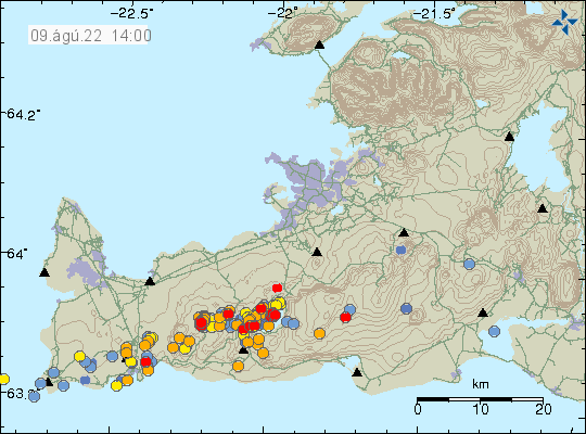
Today (9-August-2022) at 11:43 UTC an earthquake with magnitude Mw3,0 took place in Kleifarvatn lake. At the writing of this article, no other larger earthquakes have taken place. Today there has been a swarm of small earthquakes in Krýsuvík-Trölladyngja volcano and in Fagradalsfjall mountain. Some of this earthquake activity are just tectonic earthquakes, this applies mostly to earthquakes that are in Kleifarvatn lake and east of Grindavík town (might also be east of Grindavík, but I am not sure). This are because of the inflation from the dyke in Fagradalsfjalli mountain that reaches to Keilir mountain. The earthquake activity before current eruption in Fagradalsfjall mountain in Meradalir valley also caused some major fault line movements over a large area. What that is going to result in when it comes to magma movements is unclear for now.

Over the last two days there has not been any visibility on web cameras of the eruption. I am hoping that the weather might clear up later today or tomorrow but that is just wait and see. There has also been heavy rain in there and I don’t recommend that anyone going there in this weather. The area is also closed and now fines can be imposed by the police on people attempting to go there when the area is closed. Kids under the age of 12 have also been forbidden to walk to the eruption. Since the distance is 7 km one day (in total 14 km) over difficult area.
Donations
Please remember to support my work if you can. I am broke (since I am on fixed income) and everything helps. Thanks for the support. 🙂
