Continued earthquake activity in Öræfajökull volcano

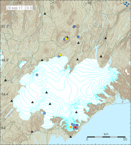
On 28 and 29th of September 2017 an earthquake activity took place in Öræfajökull volcano. Most of the earthquake that have happened are minor in magnitude, one magnitude 2,5 earthquake took place and on 29th September a magnitude 2,0 earthquake took place, this is automatic magnitude and might not be correct. The depth of this earthquake is the default one (1,1km).


The earthquake activity in Öræfajökull volcano. Copyright of this image belongs to Icelandic Met Office.

It is extremely difficult to know what this earthquake activity means if it means anything at all. The reason being that this might be part of Öræfajökull volcano normal activity that is not going to result in a eruption. There currently is no way to know for sure what this means, since last eruption took place in the year 1728 and proper monitoring of Öræfajökull volcano only started few years ago. Current activity is however slightly above normal background activity that can be expected from a volcano like Öræfajökull volcano.

Earthquake swarm west of Langjökull glacier

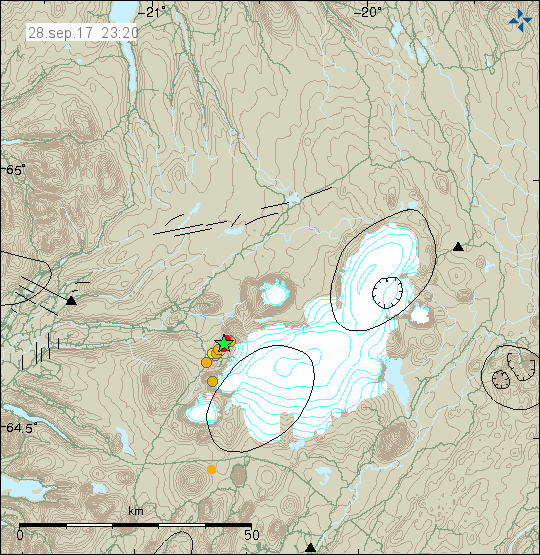
Yesterday (28-September-2017) a earthquake swarm has been taking place west of Langjökull glacier, it is close to a volcano named Presthnjúkar. It is the same system and inside its fissure swarm. The area in question has known faults from the modern era (12.000 years).


The earthquake activity west of Langjökull glacier. Copyright of this image belongs to Icelandic Met Office.

Largest earthquakes that happened had the magnitude of 2,8 and 3,1 both where felt by staff of a tourist company that operates in this area. There is no permanent population in this part of Iceland. I don’t know when this area last erupted.

Donations

Please remember to support my work. Thanks for the support. 🙂

Earthquake activity in Öræfajökull and Kverkfjöll volcano

Since this volcanoes are in the same part of Iceland I am going to write about them in the same article.

Öræfajökull volcano

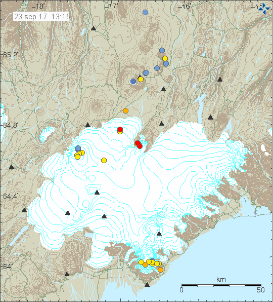
I don’t think this was a glacier earthquake activity happening in Öræfajökull volcano. I don’t know how many earthquakes took place this time around. Largest earthquakes had magnitude of 2,0 and 1,8 all other earthquakes where smaller in magnitude. Currently there is no GPS monitoring for Öræfajökull volcano that I know of.


The earthquake activity in Öræfajökull volcano and Kverlfjöll volcano. Copyright of this image belongs to Icelandic Met Office.

It is noticing how this time the earthquake swarm is all on the east side of the volcano. This earthquake activity is interesting and this also seems to signal an increase in earthquake activity in Öræfajökull volcano at least for the time being. It remains a question if this activity slows down again. Earthquake activity in this part of Iceland only happens due stress changes in Öræfajökull volcano. This is most likely influx of magma into Öræfajökull volcano but it might not erupt right away or at all (at least for a long time).

Kverkfjöll volcano

A minor earthquake swarm took place in Kverkfjöll volcano today (23-September-2017). Largest earthquake in this swarm had the magnitude of 2,1 and the second strongest earthquake had a magnitude of 1,4. The earthquake swarm was in the central part of the volcano. This is the first earthquake swarm since 2015 in Kverkfjöll volcano and the activity that year was mostly due the activity happening in Bárðarbunga volcano next to it (the dike from Bárðarbunga volcano did disturb Kverkfjöll volcano). Since this earthquake activity took place everything has been quiet in Kverkfjöll volcano.

Donations

Please remember to support my work. At the moment my fridge is getting close to be empty and it is the first time since I moved to Denmark that happens. I hope that next month (October) is slightly better. Thanks for the support. 🙂

Two strong earthquakes in Bárðarbunga volcano

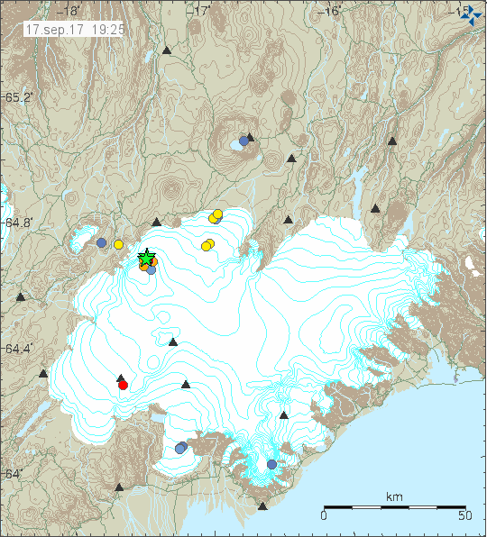
Today (17-September-2017) at 14:23 UTC two magnitude 3,9 earthquakes happened in Bárðarbunga volcano. This earthquake activity was at the north-east part of Bárðarbunga volcano caldera where earthquake activity has been taking place since September-2015. This earthquake activity is happening due to inflation in Bárðarbunga volcano.


The earthquake activity in Bárðarbunga volcano. Copyright of this image belongs to Icelandic Met Office.

Since September-2015 the rate of activity has been dropping. Now earthquake swarm happens every 11 – 18 days or so. Currently there are no clear signs that an eruption is imminent.

Small note on Þórðarhyrna volcano

On the map above a small earthquake with magnitude of 1,3 can be seen in a volcano named Þórðarhyrna. That volcano is part of Grímsfjall volcano system. Last confirmed eruption in Þórðarhyrna volcano was in the year 1902 (December) and it lasted until 12th January 1904. Not many earthquakes happen in Þórðarhyrna volcano and that suggests that an eruption might happen in this volcano without much warning. The eruption before 1902 – 1904 eruption was in 1887 and that eruption lasted until 1889. Suggesting that when eruption happen in Þórðarhyrna volcano they are long lasting and create a lot of damage as this volcano is completely covered with glacier. I make note of this because I suspect that Þórðarhyrna volcano might erupt without much warning in next few years.

Donations

Please remember to support my work with donations. At the moment I am extremely broke. Next month (October) is going to be slightly better for me as I have made changes to the tax system in Iceland. Thanks for the support. 🙂

Sharp increase in earthquake activity in Öræafjökull volcano

There has been increasing earthquake activity in Öræfajökull volcano in recent months. This increase is slow but it seems to be happening at faster phase to my surprise. For the first time the earthquake activity forms a direction along a fault line (it looks like a fault line) the direction of the fault line is east-west.


The earthquake activity in Öræfajökull volcano (south part of Vatnajökull glacier). Copyright of this image belongs to Icelandic Met Office.

This was a minor earthquake activity in terms of magnitude of earthquakes happening. With largest earthquakes only having magnitude 2,2 and all other earthquakes smaller in magnitude. Last eruption in Öræfajökull volcano took place in 1727 August 3 and ended 10 months later on 1728 May 1 +- 30 days. That eruption was a VEI=4 in size. For comparison the last eruption in Grímsvötn volcano in 2011 was also a VEI=4. I don’t know how this activity in Öræfajökull volcano is going to evolve, what seems to be clear that unlike Eyjafjallajökull volcano this change is happening a lot faster in Öræfajökull volcano then in Eyjafjallajökull volcano. Those two volcanoes are comparable of structure and volcano output (Eyjafjallajökull volcano 2010 eruption was also VEI=4). If an eruption happens in Öræfajökull volcano I would expect similar flight disruption as happened during the eruption of Eyjafjallajökull volcano. At the moment, there doesn’t seems to be any major risk of eruption in Öræfajökull volcano.

Donations

Please remember to support my work. I am now completely broke (no money in my bank accounts). In fact, I am so broke that I have changed my taxes system three months early (counting from October) just to prevent me from being this terrible broke again. Thanks for the support. 🙂

Magnitude 5,9 earthquake deep on the on the Reykjanes ridge on 10-September-2017

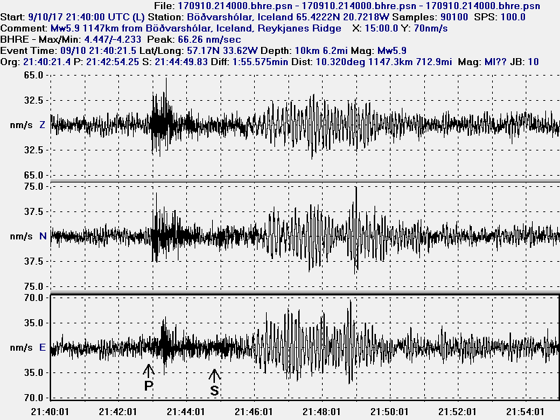
Yesterday (10-September-2017) at 21:40 UTC a magnitude (Mw) 5,9 earthquake (EMSC information here) took place deep south on the Reykjanes ridge. No aftershocks have appeared on USGS or EMSC that I am aware of. They must have happened but due to distance from land this earthquake activity was not detected.


The magnitude 5.9 earthquake deep on the Reykjanes ridge as it appeared on my geophone in Böðvarshólar. This image is under Creative Commons licence. Please see CC licence page for more details.


The magnitude 5.9 earthquake deep on the Reykjanes ridge as it appeared on my geophone in Heklubyggð. This image is under Creative Commons licence. Please see CC licence page for more details.

The distance this earthquake took place from Reykjavík is 1004 km. Only thing it did was to scare some fish at most. It is impossible to know if anything more happens at this location. It might or it might not.

Donations

Please remember to support my work with donations. I am now completely broke and there three weeks left of September. Thanks for the support. 🙂

Article updated on 12-September-2017 at 00:56 UTC. Added a link that I had forgotten.

Special report: The magnitude Mw8.1 earthquake in Mexico

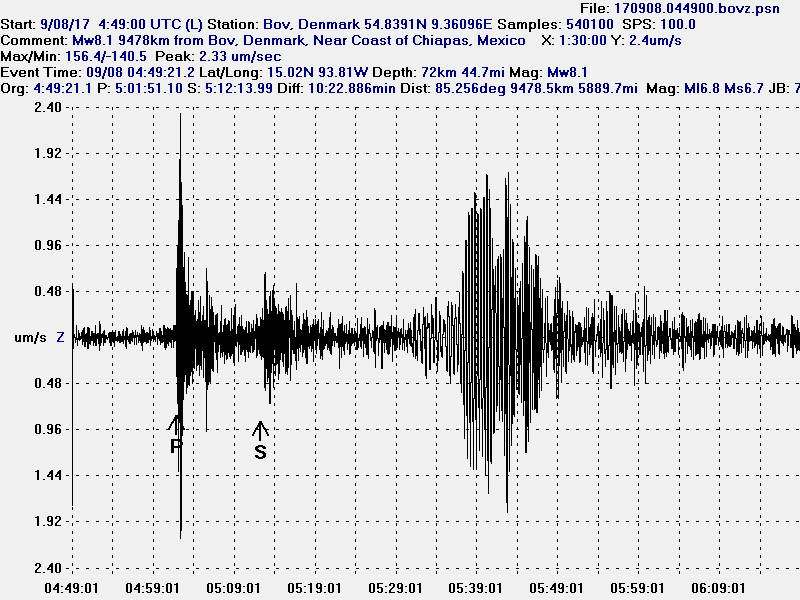
This is a special report on the magnitude Mw8.1 earthquake in Mexico.

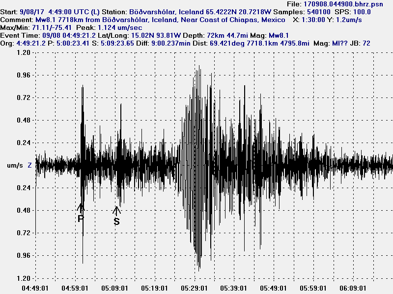
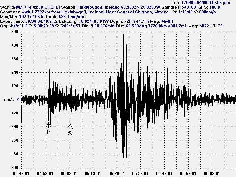
It appears that the reason for the Mw8.1 earthquake in Mexico that part of the plate above the subduction zone broke during this earthquake (?). At the moment details on this is a bit unclear, but earlier research (link) might give more details on this. I did observe this earthquake on all my geophones and this earthquake was seen on Icelandic Met Office SIL stations across Iceland.

Here is how the Mw8.1 earthquake appeared on my geophones. The signal is filtered at 0.1Hz.


The Mw8.1 earthquake in Mexico as it appeared on my geophone in Böðvarshólar, Iceland. This image is under Creative Commons licence, please see CC Licence page for more details.


The Mw8.1 earthquake in Mexico as it appeared on my geophone in Heklubyggð, Iceland. This image is under Creative Commons licence, please see CC Licence page for more details.


The Mw8.1 earthquake in Mexico as it appeared on my geophone in Bov, Denmark. This image is under Creative Commons licence, please see CC Licence page for more details.

There continues to be a high risk for strong aftershocks in this area. At least one or two magnitude 7,0 aftershocks should be expected, but they have not yet happened.

Donations

Please remember to support my work with donations. I am really broke this month and everything helps. Thanks for the support. 🙂

Strong earthquake swarm in Bárðarbunga volcano during the night (of 7-September-2017)

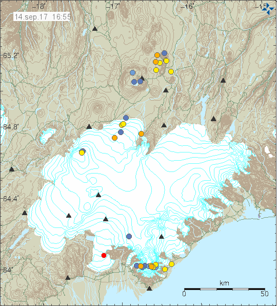
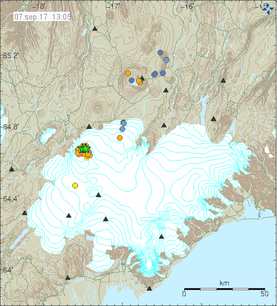
During the night of 7-September-2017 strong earthquake swarm happened in Bárðarbunga volcano. Largest earthquake had the magnitude of 4,5 and the second largest earthquake had the magnitude of 4,1. Other earthquakes where smaller in magnitude. This is the strongest earthquake in Bárðarbunga volcano since August-2017.


The earthquake activity in Bárðarbunga volcano. Copyright of this image belongs to Icelandic Met Office.

This earthquake swarm was in north-east part of the Bárðarbunga volcano caldera. This area of the volcano has been earthquake active since August-2014 when current period of activity started. This time around no harmonic tremor was detected. That might not always be the case since it is my view that there is a risk of small short lived eruptions now in Bárðarbunga volcano with connected glacier floods. This time around it just didn’t happen.

Donations

Please remember to support my work. Donations help me getting paid for all the work I put into this website and to keep my geophones up and running. Thanks for the support. 🙂
Advertisement do help, but they don’t pay a lot. I only get close to $1,15 for every 2000 page views at the moment.

Special

I am going to link to an article I am going to write in next few hours on a other website that I have. It contains information about future plans regarding this website (this is a 5 to 10 year plan I am making).

Glacier cauldrons at top of Bárðarbunga volcano caldera rim

During the eruption in Bárðarbunga volcano and the collapse of the caldera. A hydrothermal activity was seen on top of Bárðarbunga volcano caldera. Since the eruption in Holuhraun ended in February-2015 this hydrothermal activity has dropped, it has increased if anything. At the moment there are several depressions in the Vatnajökull glacier that is on top of Bárðarbunga volcano. Largest of them are 400 meters wide, I am not sure about their length. This cauldrons are around 100 meters deep and for the first time in several hundreds of years have exposed a bed rock that is normally under the glacier. Hydrothermal activity in Bárðarbunga volcano is now such that is able to melt 100 meters of glacier in several months.

This high amount of hydrothermal activity in the main volcano increases my suspicion that Bárðarbunga volcano is far from over. Since this also means that fresh magma is reaching up to 1 km in the crust in the Bárðarbunga volcano caldera rim. I don’t have any map of the locations of the calderas at the moment since none exist or at least has not yet been published. The main concern now is that this is going to increase the risk of sudden glacier floods from Bárðarbunga volcano. This might also increase the risk of sudden short volcano eruptions in Bárðarbunga volcano, either in its slopes or close to the caldera rim. As it is clear that magma has rather clear access to that part of the volcano.

Rúv News article (in Icelandic)

Gat í gegnum jökulinn (Rúv.is, Icelandic, video)

Donations

Please remember to support my work with donations. Everything helps. Thanks. 🙂

Article updated at 23:51 UTC. Text fixes.

Deep earthquake activity south and east of Bárðarbunga volcano

Since the eruption ended in Holuhraun on 27-February-2015 there has been a regular earthquake activity and dike intrusions happening south of Bárðarbunga volcano (main). I am no good with editing images at the moment so I’m going to attempt to describe the areas that are having deep earthquake activity.

First the back-story has to be looked at.

Since the end of the eruption in Bárðarbunga volcano I have been looking at data and the history of the volcano. I have come to release that the eruption cycles of Bárðarbunga volcano are a lot larger then I first thought and is agreed on in the science community. What is agreed on in the science community is that Vatnajökull glacier area has a periodic high in eruption activity every 130 – 140 years. With a period of low activity that goes on for 60 – 100 years. The only science article I was able to find on this subject was this article here. I don’t know if eruption cycles in Bárðarbunga volcano line up with wider increase in eruptions in Vatnajökull area (this includes volcanoes like Kerlingafjöll, Grímsvötn, Öræfajökull, Hamarinn (Bárðarbunga), Þórðarhyrna (Grímsvötn), Esjufjöll, Snæfell [most eastern volcano, never erupted in last 12.000 years], Askja, Tungnafellsjökull [never erupted in last 12.000 years]).

Last eruption cycle in Bárðarbunga volcano started in 1697 (unclear on error margin) and ended in 1910. That did mean a new eruption from Bárðarbunga volcano system every few years, with longest breaks lasting up to 16 years. Shortest break between eruption was only 1 year at the most. Maybe even less, due to lack of documentation during this time period shorter period can’t be ruled out. I am unsure when the eruption cycle before 1697 eruption cycle started I only know that it ended in 1477 with a possible quiet period of 220 years, but as before, this gap might only appear to be this due to lack of historical documentation during this period (or lost documents). I don’t know if current assumptions about more active periods in Vatnajökull glacier area and low periods are even correct, since I am unsure on how they got this conclusions. What can also not be ruled out is that between extremely large eruption events in Bárðarbunga volcano that it takes the volcano extra long time to recover (example, the eruption 1477 appears to have been extremely large event), but there are other factors at work in my view and this connects directly to the deep earthquake activity I’ve been seeing around Bárðarbunga volcano since 2015 and before that (going back several years).

The areas I have seen deep earthquakes take place are this ones.

Trölladyngja, earthquakes have appeared deeper then 20 km.
In Dyngjujökull glacier area. This area is also subject to dike intrusion 5 – 8 km south of it.
Dyngjuháls area. It is part of Dyngjujökull glacier area, just north of it.
Kistufell area.

During the first days of 2014 eruption in Bárðarbunga volcano (before the Holuhraun eruption started), magma did flow into Dyngjuháls area. As can be seen on this image from August-2014.
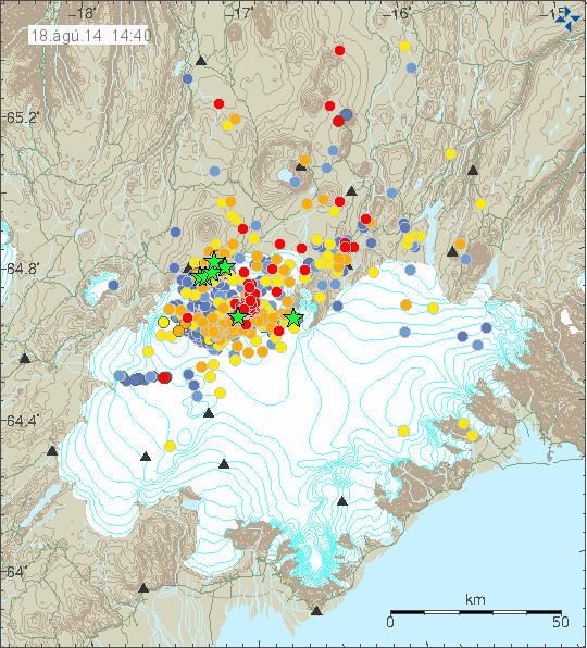

This image is from August-2014. Copyright of this image belongs to Icelandic Met Office.

This magma never erupted and appears to be there in what seems to be a magma chamber. It remains a question if this magma chamber is now starting to overpressure and is going to erupt in next few years. As for Dyngjujökull glacier area, that is even a more mystery since no magma camber clearly visible in the data. That suggests there might be a magma chamber at greater depth then normal under Dyngjujökull glacier area. It is not possible to know when next eruption is going to happen in Bárðarbunga volcano, but based on historical data next eruption might happen in the next 3 to 16 years (counting from 2015).

Donations

Please remember to support my work with donations. Without them I am going to have problems financially this September. I have found a solution to my financial problems and that involves moving back to Iceland in July-2018. The worst of my finical problems is going to persist until December-2017, from January-2018 and until July-2018 my situation is going to be slightly better. It is not going to be great from January and until July-2018. After July-2018 I won’t have any major problems financially. This happens due to Iceland and Denmark tax system complexities as I get paid from Iceland and tax is paid there and on top of that living in Denmark results in smaller social welfare payment. By moving to Iceland I am going to increase my social welfare payment (as the system is set-up this way) around 799,49€ a month. Iceland is far more expensive then Denmark (up to 66% more expensive), but with clever buying strategy for food and other stuff I should be able to have it decent in Iceland (unlike my current status now living in Denmark). As always, thanks for the support. 🙂

Article updated at 20:42 UTC. Minor text fixes.