Strong earthquake swarm in Bárðarbunga volcano (30-June-2017)

Today (30-June-2017) a strong earthquake swarm took place in Bárðarbunga volcano. This earthquake swarm was in the north-east area of the Bárðarbunga volcano caldera, area that has showed the most earthquake activity since this started in September-2015. Why that is the case is unclear at the moment.
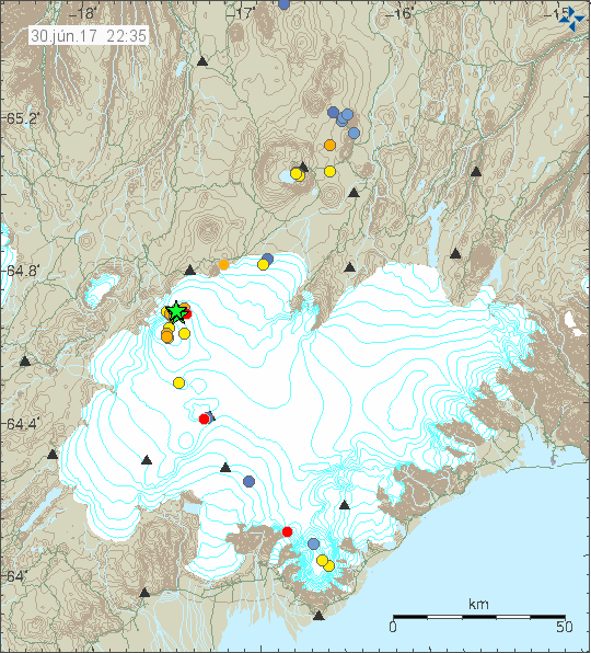

The earthquake activity in Bárðarbunga volcano. Copyright of this image belongs to Icelandic Met Office.

Strongest earthquake in this swarm had the magnitude of 3,6 but other earthquakes where smaller, one earthquake with magnitude 3,4 and one earthquake with magnitude 3,1. All other earthquakes where smaller in magnitude. This earthquake swarm seems to be over for now, but one new earthquake took place at 22:29 and had the early magnitude of 2,7 (or 2,8).

North sea earthquake

I don’t often record an earthquake this close to where I live in Denmark. This is a magnitude 4,8 earthquake (EMSC information) that happened in the North sea. This earthquake was felt in Scotland and Shetland Islands, I don’t know about Norway as the closest distance from Norway was 195 km of Åkrehamn village.
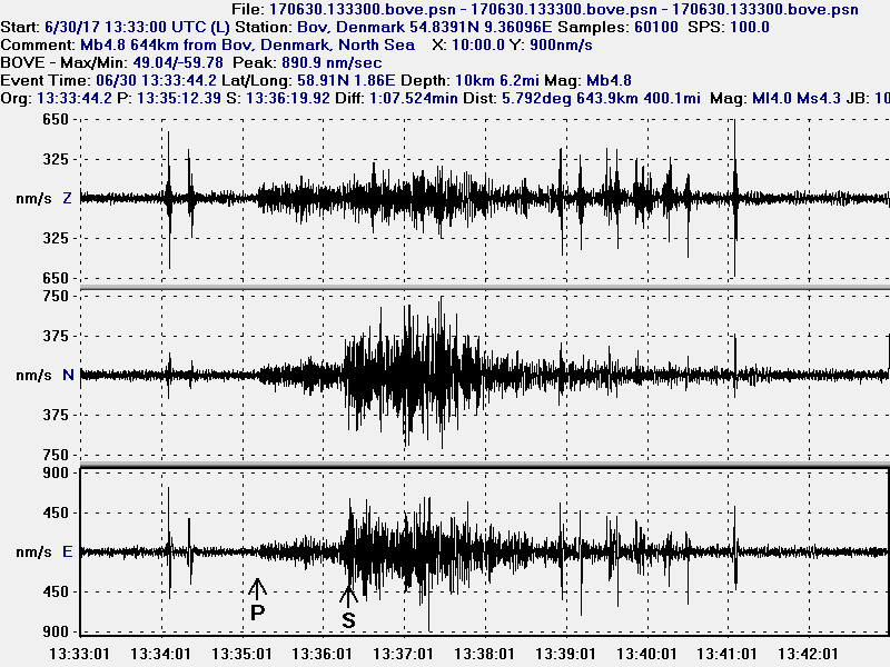

The north sea earthquake as it appeared on my geophone in Bov, Denmark. The distance is 644 km. This image is released under Creative Commons licence. Please see CC licence website for more details.

Donations

Please remember to support my work with donations. It helps me keeping this website going and continue to write about what happens in Iceland and on a occasion elsewhere. Thanks for the support. 🙂

Strong earthquake activity on Kolbeinsey ridge (26-June-2017)

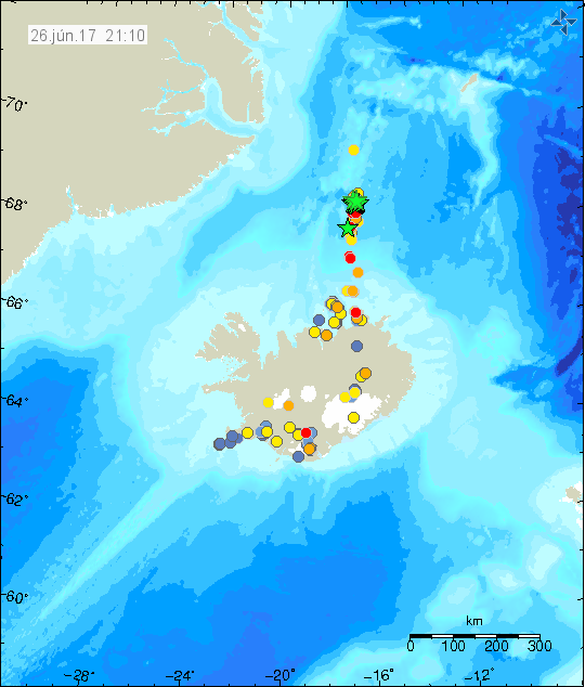
During the night of 26-June-2017 an earthquake swarm started north of Kolbeinsey island on Kolbeinsey ridge. This earthquake swarm is located around 355 km north of Siglufjörður village making it difficult to know for sure what is going on there. Largest earthquake so far had the magnitude of mb4,4 (EMSC Information), at the moment this is the only earthquake to register with EMSC. Total of 20 earthquakes have been over magnitude 3,0 so far, as this earthquake swarm is ongoing that number is going to change in the next few hours.


The earthquake activity on Kolbeinsey ridge (green stars). Copyright of this image belongs to Icelandic Met Office.

I don’t know yet if there is any eruption at this location. At this distance the SIL network might not register the harmonic tremor of a small eruption or dyke intrusion. Ocean depth at this location is 2 – 3 km and that rules out any major signs appearing on the surface of the ocean. Currently there seems to be a break between earthquake swarms, that is just how it appears as the SIL network is not able to detect any small earthquakes at the distance of 355 km (about) and that means only minority of earthquakes is being recorded. There is also a possibility that this is just a normal rift earthquake activity that happens at this location, the area I think is is a rift valley, but this being a dyke or an volcano eruption can’t be ruled out.

This article is going to be updated if needed.

Donations

Please remember to support my work with donations. It helps keeping me afloat financially. Thanks for the support. 🙂

Katla volcano earthquake activity – Update 2

Earthquake activity continues in Katla volcano with activity dropping between swarms. It is unclear at the moment if this is going to result in a eruption but at the moment it is my view that chances of an eruption happening soon (maybe in matter of hours) is high. Official view (government) is more conscious about what is going on in Katla volcano and does not yet issues this type of statements.


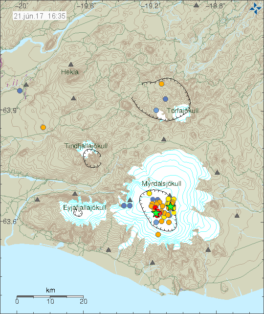
Current earthquake activity in Katla volcano. Copyright of this image belongs to Icelandic Met Office.

Largest earthquake today had the magnitude of 3,4 at the depth of 0,1 km. Yesterday magnitude 3,6 earthquake had a fore-shock of magnitude 1,9 at the depth of 14,4 km. This is unusual and suggests that the reason for the current earthquake activity is an injection of new magma, rather than moving of old magma in Katla volcano system. For that reason I’m expecting more earthquake activity in next few hours. This change in activity appears clearly in the earthquake activity that has been taking place, the earthquakes that have happened have variety of depth, with most depth at 15,5 km and up to 0,1 km.

There appears to be a cycle of earthquake activity with quiet period between them that last for few hours at the time. The cycles appear to be getting shorter. I don’t know why that is, but this suggest that Katla volcano is getting more unstable as this earthquake activity. I don’t know yet if it does the same thing as last year (2016) when a swarm of activity started and then dropped after few months of activity. Few SIL stations appears to be showing slightly higher tone on 2 – 4Hz band (just two at the moment). I don’t know why that is. Currently the situation is quiet, I am however expecting that to change without warning at any time. If anything more happens remains be seen, but the chances are high at the moment.

Update 1

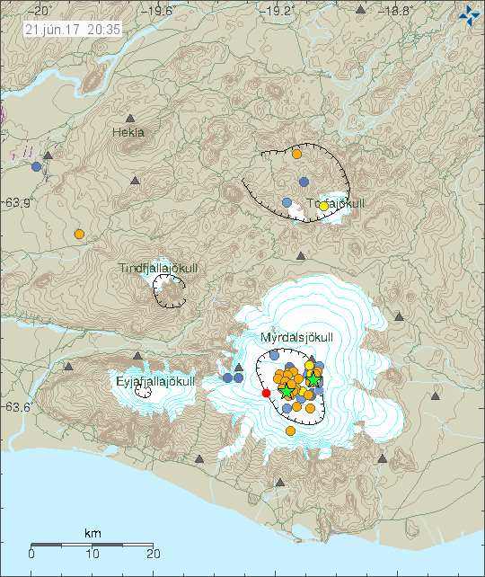
There has been a new depth record in this swarm. Earlier 15,5 km earthquake has been relocated down to 25,0 km depth. At this depth it is only magma that can make an earthquake, normal tectonic processes do not work at this depth in Iceland since Iceland is not a subduction zone with deep earthquakes. Just three new earthquakes have appeared in last few hours and current activity remains quiet.


Current earthquake activity in Katla volcano. Copyright of this image belongs to Icelandic Met Office.

There is a lot to suggest that this increase in earthquake activity in Katla volcano is not over. This quiet periods where also observed during large earthquake activity in August-2016. I don’t know why this quiet period happens, they just do.

This article is going to be updated today (21-June-2017) if something more happens.

Article updated at 20:56 UTC. Added new information.

Fluid reason for earthquake swarm north-east of Flatey in Skjálfanda, Tjörnes Fracture Zone

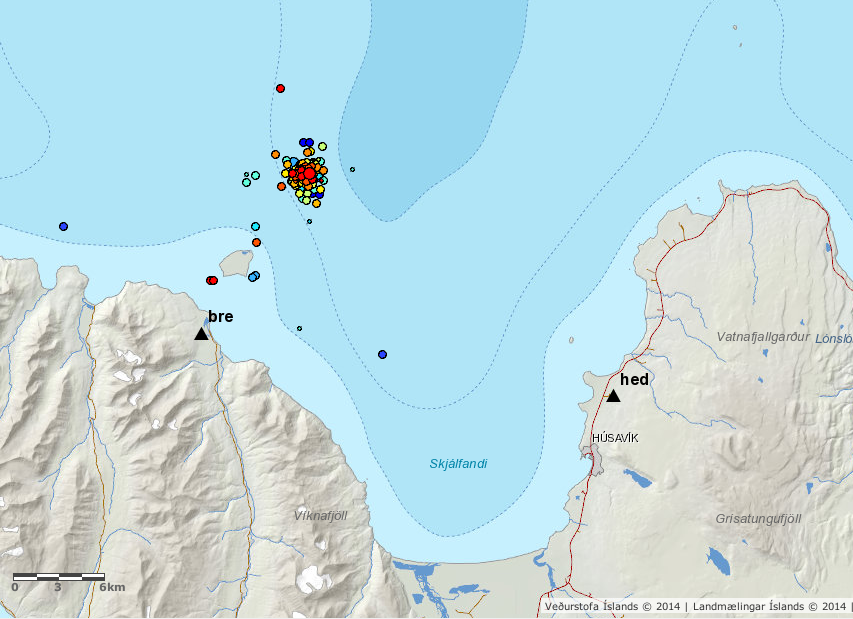
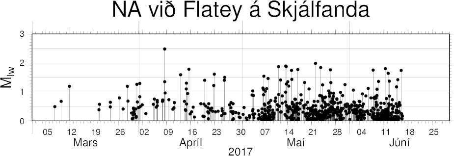
In March-2017 an earthquake swarm started north-east of Flatey in Skjálfanda in Tjörnes Fracture Zone. This earthquake swarm is ongoing as is. Largest earthquake this this swarm only has the magnitude of 2,5. All other earthquakes have been smaller in magnitude, since March around 800 earthquakes have been recorded north-east of Flatey in Skjálfanda.


Flatey in Skjálfandi earthquake activity since March-2017. Copyright of this image belongs to Icelandic Met Office.

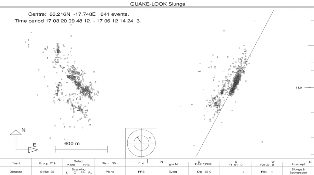
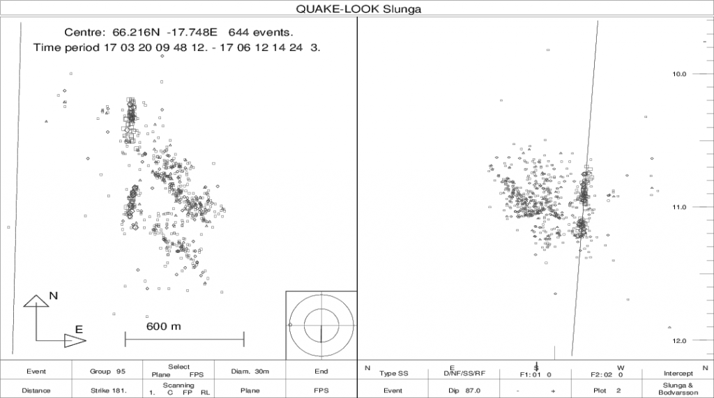
There are two faults at work here, the first one is in north direction and close to vertical. The other is in the direction of NW-SW (around 145 degrees east) and has an angle of 60 – 70 degrees. Depth is around 10,5 to 11,5 km. Since March, according to Icelandic Met Office report the earthquake activity has slightly migrated north. As the earthquake activity has moved north, they have moved upward to a slightly shallower depth.


The NW-SW fault plane in the earthquake swarm north-east of Flatley in Skjálfanda. Copyright of this image belongs to Icelandic Met Office.


The fault plane that is almost directly north and vertical. Copyright of this image belongs to Icelandic Met Office.

There are clues in this earthquake swarm that it is caused by some type of fluid migrating in the faults at this location. What type of fluid this might be is not possible to know. There are no known volcanoes at this location or any historical accounts of an eruption in this location. I don’t know if there are many options for what type of fluid this might be pressing it self up at this location, magma is one possibility but this might also just be water moving upwards in the crust at this location.


Number of earthquakes north-east of Flatey in Skjálfandi since Marc-2017 until June-2017. Copyright of this image belongs to Icelandic Met Office.

Donations

Please remember to support my work with donations. Thanks for the support. 🙂

Article updated at 00:47 UTC. Location error fixed. I confused fjords in the area together.
Article updated at 01:47 UTC. I forgot the image with number of earthquakes at north-east of Flatey in Skjálfandi.

Sharp earthquake activity in Katla volcano – Update 1

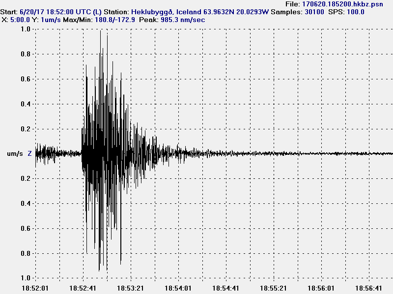
Tonight (20-June-2017) there has been a sharp increase in earthquake activity in Katla volcano. Largest earthquake so far had the magnitude of 3,6. At the moment I’m not sure about other earthquakes magnitudes. I’ll update this article once I have them. The current situation seems be less stable than it appears (based on IMO notice earlier this evening).


Current earthquake activity in Katla volcano. Copyright of this image belongs to Icelandic Met Office.

The harmonic tremor plots have not yet updated for the area around Katla volcano. They update only once every 30 minutes that leaves me currently without any harmonic tremor data at the moment. I’ll post an update once I have those updates.

At the writing of this article an eruption has not yet started. That might change without warning.

This article is going to get update or a new written as this situation develops.

Update 1

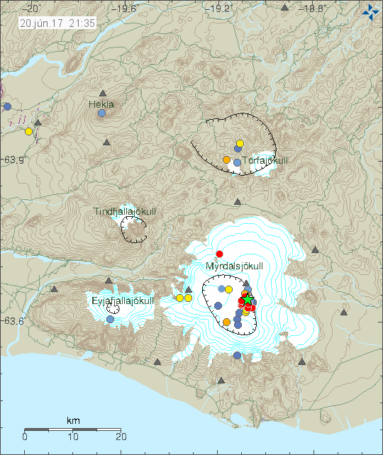
Activity in Katla volcano has gone back to background levels in the last few hours. This is the second earthquake swarm in Katla volcano in the last two days, the last one being on the 19-June-2017. Nothing unusual is appearing on the harmonic tremor plots at the moment.


The earthquake activity in Katla volcano at 21:35 UTC. Copyright of this image belongs to Icelandic Met Office.


The main earthquake so far with magnitude 3,6. This image is filtered at 1Hz due to wind noise. This image is released under Creative Commons Licence. Please see CC Licence page for more details.


The second earthquake activity. It is strange to look at on this plot. Seems to be one long continuous earthquake until it drops off. This image is released under Creative Commons Licence. Please see CC Licence page for more details.

Currently there are strong wind in south Iceland making it difficult for me to monitor Katla volcano due to wind and ocean wave noise.

This article was updated at 21:45 UTC.

Earthquake swarm in Katla volcano (18-June-2017)

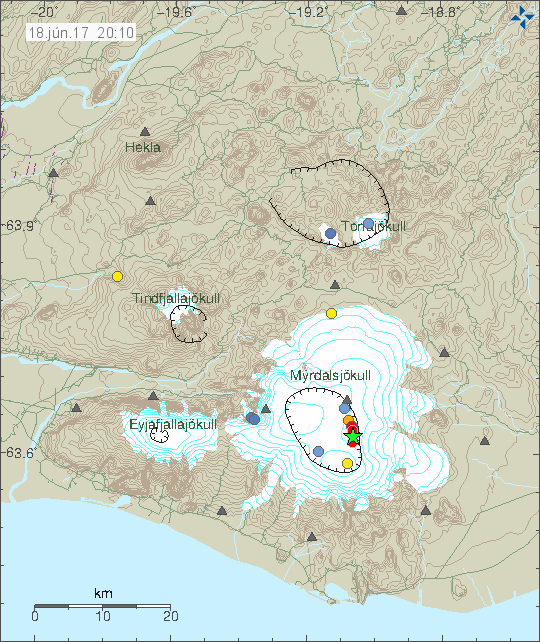
Today (18-June-2017) an earthquake swarm took place in Katla volcano. Largest earthquake in this swarm had the magnitude of 3,2 and the second largest earthquake had the magnitude of 2,8 (two earthquakes). Depth was registered at 0,0 km. That means it was below the error margin Icelandic Met Office has, that error margin is around 300 meters +-.


Earthquake activity in Katla volcano today. Copyright of this image belongs to Icelandic Met Office.

This earthquake swarm was close to being directly in north-south direction. At the moment the earthquake activity has gone back to background levels and no other activity appears to be taking place at the moment. I don’t know yet if this earthquake swarm activity is part of the normal summer earthquake activity or something else happening. Only time is going to make that clear.

Donations

Please remember to support my work here. Every donations helps me in keeping this website up and running. Thanks for the support. 🙂

Earthquake activity in Öræfajökull volcano (13-June-2017)

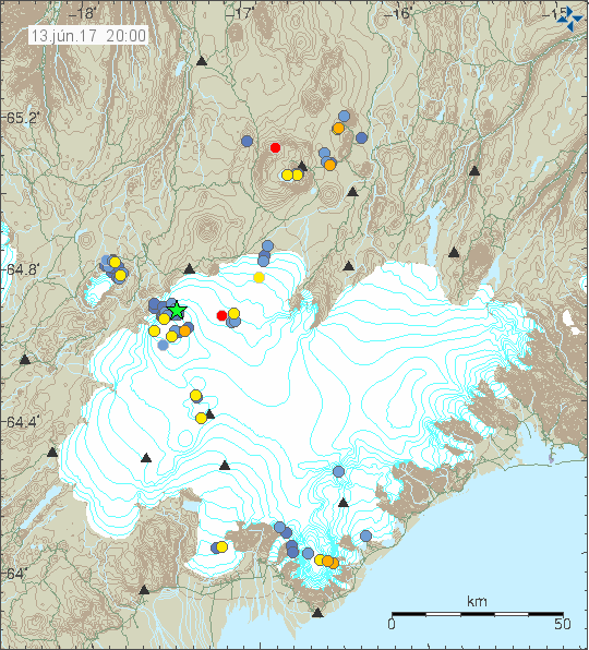
Today (13-June-2017) a magnitude 2.6 earthquake took place in Öræfajökull volcano. This is the largest earthquake in this volcano for a long time now and it is worth noting that Öræfajökull volcano normally doesn’t have any earthquake activity. This suggests that something might be up if it doesn’t start to quiet down in next few years. Earthquake activity in Öræfajökull volcano is not high as can be seen in this science paper that covers the years 1994 – 2007 in earthquake activity in Iceland.


Earthquake activity in Öræfajökull volcano (to the south on this image). Some of the activity might be glacier quakes due to summer heat or rain. Copyright of this image belongs to Icelandic Met Office.

Tectonic settings in this area don’t allow for a lot of crustal-tension earthquakes and that suggests that the source of current earthquake activity in Öræfajökull volcano can be explained by magma movements. If this is going to end in a eruption remains to be seen. At the moment current low level activity rules that out, since a lot more and stronger earthquake activity needs to happen before magma can reach the surface.

Donations

Please remember to support my website with donations. It helps me surviving the month. Thanks for the support. 🙂

Sharp increase in earthquake activity in Tungnafellsjökull volcano

During the last few days there has been a sharp increase in earthquake activity in Tungnafellsjökull volcano. Since there has been no eruptions in the last 12.000 years it is not possible to know for sure what is going on. The earthquake activity suggests that this is a mixture of magma connected earthquakes and stress changes due to Bárðarbunga volcano changes. Making it nearly impossible to know for sure what is going on, at least for now anyway.


Tungnafellsjökull volcano is located north of Bárðarbunga volcano. It is marked by cluster of small earthquakes (red dots) on this image. Copyright of this image belongs to Icelandic Met Office.

What is different now, is that after a long period of quiet there was a sharp increase in earthquake activity in Tungnafellsjökull volcano. If past earthquake swarm activity is anything to go by I expect this earthquake activity to die out slowly and activity should go back to normal in Tungnafellsjökull volcano. That means no earthquake activity at all. I don’t think that anything has changed in that volcano, at least I don’t have any hard evidence of that being the case for the moment. That might change since lack of historical eruptions leaves a room for lot of speculations.

Donations

Please remember to support my work. That helps me in get trough June in my current financial problems (due to dentists costs). Thanks for the support. 🙂

Weekly earthquake in Bárðarbunga volcano (12-June-2017)

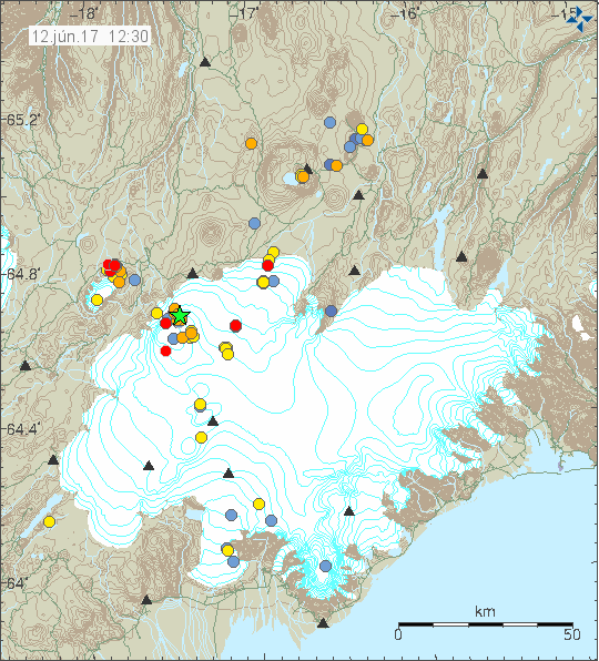
Today (12-June-2017) a magnitude 3,6 earthquake took place in Bárðarbunga volcano. This earthquake activity is mostly normal for Bárðarbunga volcano, there has been slight increase in earthquake activity in Bárðarbunga volcano during the past few days (minor earthquakes), why that increase is taking place is unclear at the moment. This increased happened at the same time as a sharp increase in earthquake activity took place in Tungnafellsjökull volcano (read the article about that for more information).


The earthquake activity in Bárðarbunga volcano and Tungnafellsjökull volcano. The green star shows the magnitude 3,6 earthquake. Copyright of this image belongs to Icelandic Met Office.

Currently the activity in Bárðarbunga volcano is mostly what is now considered ‘normal’ after the 2014 – 2015 eruption. I don’t know if that status is about to change, but there are clues in current activity suggesting that might be about to happen. This increased activity however might slow down again and go back to normal background levels.

Donations

Please remember to support my work. As it helps me to get trough the month of June. Thanks for the support. 🙂
Earthquake swarm west of Langjökull glacier

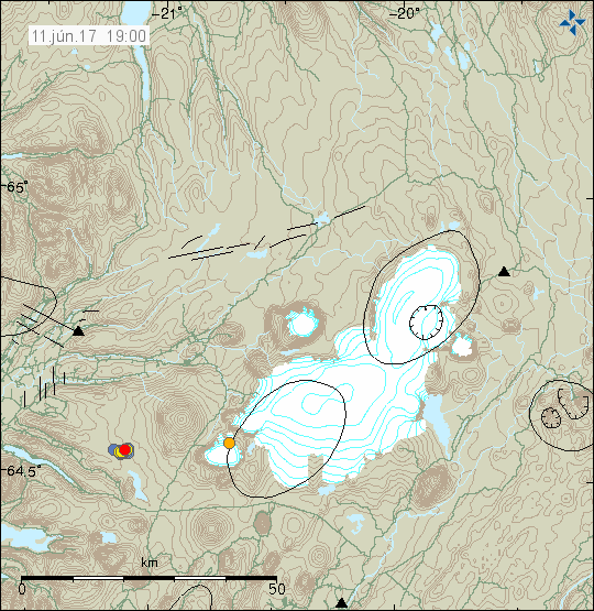
Few weeks ago an earthquake swarm started west of Langjökull glacier and is on the edge of western fracture zone. That earthquake swarm then stopped and has now started again and it appears that the magnitude of the earthquakes is increasing. The magnitude has gone from mostly 1,0 and up to mostly 2,0.


The earthquake activity west of Langjökull glacier. Copyright of this image belongs to Icelandic Met Office.

This earthquake swarm has all the signs of being intra-plate earthquake swarm, but due to location of it’s hard to be sure if that is the case. No fault lines are document at this location, that means no major earthquake activity has taken place there for a long time.

Donations

Please remember to support my work with donations. I am currently going trough a difficult month. Thanks for the support. 🙂