Heavy earthquake activity in Katla volcano, high conductivity in glacier rivers

This is going to be a short article, as the current situation is constantly changing.

Earthquake swarm started around 03:00 UTC (29-September-2016) in Katla volcano, this earthquake swarm has been heavy due to high number of earthquakes, when this is written around 88 earthquakes have been recorded in Katla volcano. This number is going to change as the earthquake activity continues.
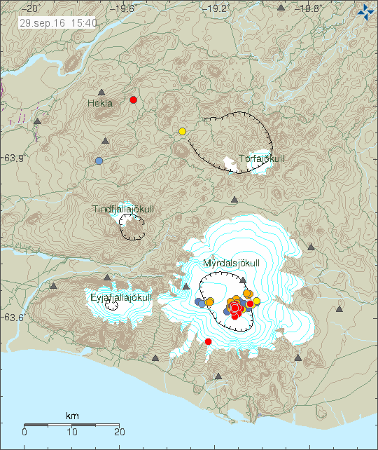
160929_1540
The earthquake activity in Katla volcano. Copyright of this image belongs to Icelandic Met Office.

According to a statement that Icelandic Met Office issued the conductivity in glacier rivers from Katla is higher than normally during this time of year. At current it is 190uS and according to the Icelandic Met Office this is not normal during this time of the year. At the present no harmonic tremor has appeared, if it appears it is going to be clear on the SIL stations around Katla and maybe good distance away from the volcano. As it is going to override any background noise that might be happening (wind, noise, traffic).

This article is going to be updated as I learn more.

Update at 19:00 UTC

The earthquake activity has continued today as before, there have been small drops in activity for up to a hour, after that the earthquake activity continues. Currently (when this is written) there is a low in the earthquake activity. Largest earthquake was at 16:28 UTC and had the magnitude of 3,0. Other earthquakes have been smaller in magnitude.
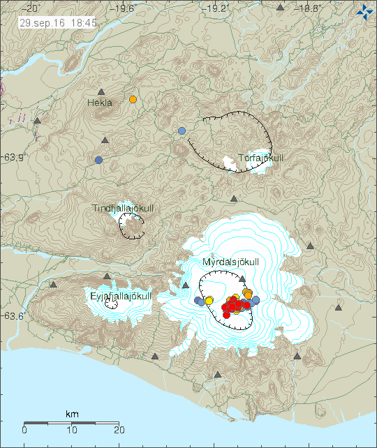
160929_1845
The earthquake activity at 18:45 UTC. Copyright of this image belongs to Icelandic Met Office.

Update on earthquake area location

Most of the earthquake activity today (29-September-2016) has been taking place north of cauldron 16 (see map). This makes it less likely to be connected to hydrothermal area and changes in that type of area. Since hot-springs create the cauldron seen in the Mýrdalsjökull glacier, the heat melts the bottom of the glacier and creating glacier outburst once in a while. It does appear that the earthquake activity has extended it self into cauldrons 10 and 11 and maybe cauldron 16, but I’m not sure on that detail currently.
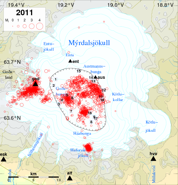
katla2011
Earthquake activity in Katla after the year 2011. Cauldrons are marked with numbers and location on this map. Copyright of this map belongs to Icelandic Met Office. Source link.

Article updated at 16:05 UTC. Time corrections on when this activity started.
Article updated at 19:00 UTC. Updated added.
Article updated at 19:47 UTC. Map added from 2011.

Overview of micro-earthquake activity in Iceland 28-September-2016

This is a short overview of the micro-earthquake activity in Iceland on 28-September-2016. Please note that some of this earthquake activity may have started some days ago and only got really busy on 28th September 2016.

Kolbeinsey Island / Ridge

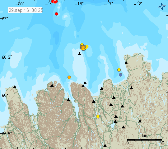
Late on the 28-September-2016 an earthquake swarm took place in Kolbeinsey Island / Ridge. This is the largest earthquake swarm in this article. With the largest earthquakes having the magnitude above 3,0. Due to distance from the SIL network exact calculation of the magnitude and depth doesn’t appear to be possible. Last eruption taking place in Kolbeinsey Island / Ridge took place in the year 1755. No other eruptions have been documented since, but they might regardless have happened. The area is far from land and difficult to observe.

East of Grímsey Island (Tjörnes Fracture Zone)

Minor earthquake swarm has been taking place earth of Grímsey Island in a area that many suspect is a volcano (it is marked as such in the GVP database). The earthquake swarm in question does not appear to be a volcanic in origin. This appear to be a tectonic activity taking place, as the movement of TFZ is 20mm lateral movement/year (they fault slide each other 20mm/year) the rift movement is only 5mm/year (eastern part only). Image showing the movements can be found here (vedur.is).

160929_0025
Earthquake activity in Kolbeinsey Island and Tjörnes Fracture Zone. Copyright of this image belongs to Icelandic Met Office.

South Seismic Zone (SISZ)

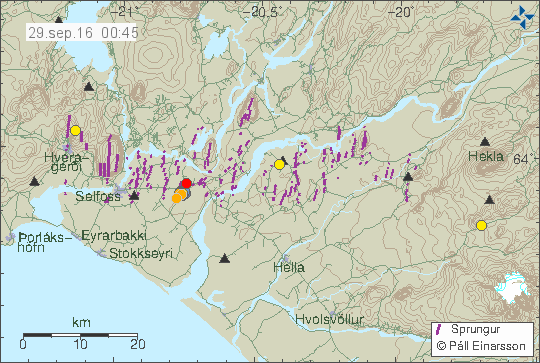
A small swarm of earthquakes has been taking place in SISZ this week. The largest earthquake in this swarm has only had the magnitude of 2,1. The activity is only minor and does not suggest a large earthquake is about to happen. This might be aftershocks of the earthquakes in 2000 or 2008.

160929_0045
The earthquake activity in SISZ. It’s only minor and west of Selfoss (red dot). Copyright of this image belongs to Icelandic Met Office.

Reykjanes peninsula

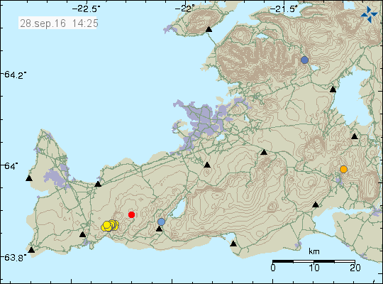
Earthquake swarm started on 28-September-2016 on the Reykjanes peninsula. This earthquake swarm was not strong and the largest earthquake in this swarm only had the magnitude of 2,1 and all other earthquakes where smaller in magnitude. Total of 60 earthquake happened when the swarm was active.

160928_1425
The earthquake swarm on the Reykjanes peninsula. It was not big in magnitude, but had a total of 60 earthquakes. Copyright of this image belongs to Icelandic Met Office.

Few earthquake have also been taking place around Iceland without any other activity. This type of one-off earthquake activity is common in Iceland. Why it happens is unclear.

Article updated at 02:03 UTC on 29-September-2016. Word corrections.