Minor earthquake swarm in Torfajökull volcano

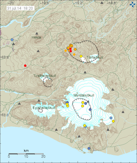
Today (31-July-2014) a minor earthquake swarm took place in Torfajökull volcano. This was a minor earthquake swarm and no earthquake did go above magnitude 3,0. Strongest magnitude of this earthquake swarm had the magnitude of 2,3. Depth of this earthquake swarm was from 15,1 km to around 1,0 km.

140731_1820
The earthquake swarm in Torfajökull volcano. Copyright of this image belongs to Icelandic Meteorological Office.

This earthquake swarm appears to be over, at least at the moment. It might start again at later time. Earthquake activity is common in Torfajökull volcano and there are no signs of any other activity from Torfajökull volcano at the moment.

More details on the landslide in Askja volcano

Over the past few days scientists from Icelandic Meteorological Office and University of Iceland, geology department have been studying the massive landslide in Askja volcano. The area is considered unstable as is and might remain unstable for the next year and even longer. Risk of new landslide in Askja is not higher now than normal, but even so the walking paths around Askja lake are going to remain closed due to changes that took place when the flood wave hit the volcanic crater coastline following the landslide.

It remains unclear why this landslide took place. It does not seem that wet soil is the reason for this, as was originally thought. Some speculation have been that this might be due to increased hydrothermal (hot springs) activity in Askja volcano. Nothing has yet been proven on what did cause this large landslide. There have also been news items that a earlier landslide around the same size might have taken place in Askja volcano in the years 1902 to 1960 (exact date is not known). Current size estimates are that the landslide is around 50 million cubic meters in size and around 700 meters wide at the top. More research is going to give more details on this landslide in the future. The seismic signal and following harmonic tremor that was detected following this landslide has a detailed analyse here on Icelandic Meteorological Office website.

If more landslides do happen in Askja volcano I am going to publish that information soon as possible. If more information is going to be published I am going to post them soon as possible.

Donations: Please remember to donate to support my work. Due to my move to Iceland in December I have updated the information here. Please take a note of the changes that are going to take place in January 2015. Thanks for the support.

Article updated at 00:10 UTC on 26-July-2014.

Updated information on Askja volcano landslide

This is a short update on Askja volcano landslide.

Travel ban is still in effect to Askja volcano. Parts of it are going to be lifted later today or tomorrow, but access to Askja lake is going to remain forbidden at least until Friday, after estimates on risk of new landslides have been performed by Icelandic Meteorological Office and Civil Protection in Iceland (Almannavarnir). Risk of new landslides taking place in this area remains and might remain for many months to come. It is now estimated that 50 to 60 million cubic meters of material did collapse down into Askja lake, but with only part of the material ending up into the lake it self. New estimates on the flood waves that where created now put them around 50 meters high, there was also not one wave that took place, but it is now estimated that four waves took place once the landslide hit the water.

Hiking paths to Askja volcano and Víti have been closed due landslide risk in the area around Askja lake. Please respect this closure since this area is now highly unstable and more landslides might fall without warning.

Update 1: The landslide (or rock slide as IMO calls this) is now estimated to be around 1 km wide. The tsunami waves that followed this landslide in Askja lake are now estimated to have been around 73 meters high (around Hallgrímskirkja church high). The area remains closed and is now regarded as highly unstable. Risk of new landslides in this area remains high at current time. The amount of soil that did just go into Askja lake is estimated to have been around 24 million cubic meters, with the total amount much higher (this is unconfirmed number).

I will post more information as more is known what happened.

Icelandic news of this

„Bráðabani“ að fara niður að vatn­inu (mbl.is)
Víga­leg­ur mökk­ur steig til him­ins (mbl.is, pictures)
Lukka að þetta gerist um miðnætti (Rúv.is)
Svona lítur Askja út í dag – Myndband (Rúv.is, video of Askja today)
Askja – fyrir og eftir berghlaupið (Rúv.is, this are before and after images of Askja)
Berghlaupið í Öskju eitt það stærsta (Rúv.is, new video of Askja area)

Donations: Please remember to donate to support my work (and keep me away from starving). I will move back to Iceland in December (see here). Thanks for the support.

Article updated at 13:55 UTC.
Article updated at 16:01 UTC.
Article updated at 22:16 UTC.
Article updated at 22:18 UTC.
All traffic to Askja volcano forbidden due to a large landside yesterday (22-July-2014)

According to Icelandic Meteorological Office, a large landslide fell yesterday (22-July-2014) around midnight in Askja volcano, the landslide did go into Askja lake creating a flood wave that was 100 to 200 meters high. It did reach the other end of the crater lake and did flow over its edge, some water did go into Víti crater. This landslide took place in south part of the Askja lake crater (best information I have at the moment). Harmonic tremor was detected following this events, it was recorded for 20 minutes according to news reports (no image since Askja harmonic tremor plot image is missing in IMO website).

A cloud was seen following this landslide, it is not clear if it was steam or just loose dirt material moving up into the air. Early estimates into this landslide are that around 24 million cubic meters of material did come down with this landslide, part of it ending in Askja lake and raising the water levels in Askja lake some two meters (early estimates). Until this matter has been checked by scientist and Almannavarnir in Iceland, all traffic to Askja volcano is forbidden. There is also a risk of more landslides taking place in Askja volcano, since the soil where the landslide took place might not have settled yet. It is highly dangerous to go there under the current conditions and I urge anyone not to go there due to how dangerous this area now is.

Update 1: Image of the landslide can be found here.

I am going to post more information about this once I have more details on this event.

Icelandic news on this

Öll umferð bönnuð um Öskju eftir gríðarlega stóra skriðu (DV.is)
Umferð um Öskju bönnuð eftir stóra skriðu (Rúv.is)
Stór skriða féll í Öskju­vatn (Mbl.is)

Donations: Please remember to donate. While I am going to move back to Iceland in December. I still have to make it until then (somehow). Thanks for the support.

Article updated at 00:34 UTC on 23-July-2014.

Earthquake swarm in Katla volcano

Few days ago the uncertainty level around glacier rivers that come from Mýrdalsjökull glacier have been cancelled. However the area remains dangerous due to gases that might collect in pockets in low lying areas. So it is not safe to go close to the glacier rivers from Mýrdalsjökull glacier even if the uncertainty level has been cancelled by the authorities.

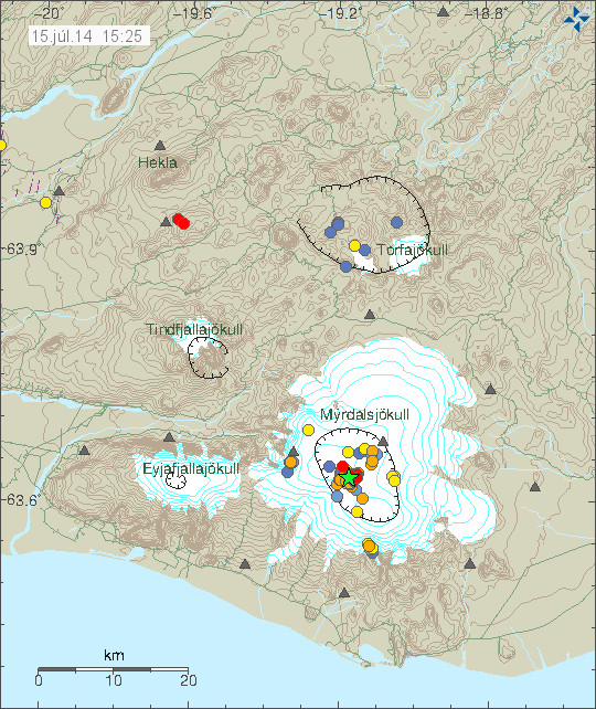
140715_1525
Earthquake activity today in Katla volcano. Copyright of this image belongs to Icelandic Meteorological Office.

Today (15-July-2014) an earthquake swarm took place in Katla volcano. Largest earthquake in this swarm had the magnitude of 3,1. Other earthquake that happened where smaller. This earthquake swarm is one of the most dense in the past few weeks and it appears that earthquake activity is once again on the rise in Katla volcano. I am now expecting this earthquake activity to continue. I also think there is a high risk of small eruptions within the Katla volcano caldera. This eruptions would only last for few hours at the most and not even break trough the Mýrdalsjökull glacier. It has to be noted that scientist on duty at Icelandic Meteorology Office does not agree with my opinion. While there is a high risk of this (in my opinion) that this might happen, it does not mean it is going to do so. The best thing that can be done for now is to observe activity in Katla volcano.

If anything more happens. I am going to post update on it soon as possible. Any large earthquakes that happen in Katla volcano do appear clearly on my geophone at Heklubyggð and they can be viewed here. There is also a web camera of Katla / Eyjafjallajökull located here.

Lower conductivity detected in glacier rivers from Mýrdalsjökull glacier (Katla volcano)

Today (12-July-2014) it was reported in the news that conductivity in rivers coming from Mýrdalsjökull glacier are showing signs of less conductivity and lower water levels. There is still an uncertainty level in effects around this area, since level of dissolved gases from the rivers remains at close to dangerous levels at current time.

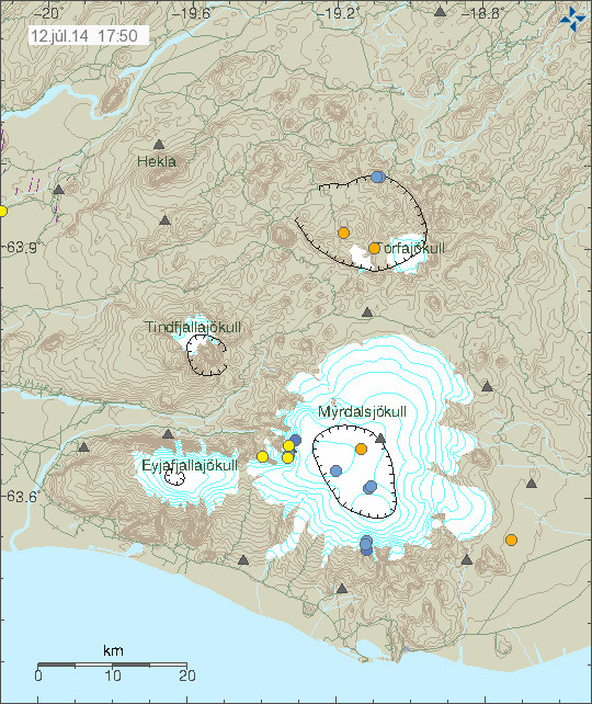
140712_1750
Lower earthquake activity in Katla volcano. Copyright of this image belongs to Icelandic Meteorological Office.

Earthquake activity in Katla volcano has dropped below background levels. So there is now less activity taking place in Katla volcano as is, if this quiet is going to remain is impossible to know at current time. This low earthquake activity might change without warning, since that has happened in the past (observed in the past few years).

If anything changes I am going to post update about it soon as possible.

Other: In December-2014 I am going to move back to Iceland. Why that is can be read here (in English).

Donations: Please remember to support my work and keep me from being broke. Thanks for the support.

Uncertainty level declared at Katla volcano

Today (8-July-2014) a uncertainty level was declared at Katla volcano. This means that people should be aware of the activity that is now taking place in Katla volcano. The most dangerous areas at the moment are the glacier rivers that come from Katla volcano, due the extremely dangerous gases that are in the water coming from Mýrdalsjökull glacier. People should not stop at Múlakvísl glacier river and other glacier rivers that come from Mýrdalsjökull glacier due to this danger. It is also unclear if an larger glacier flood might take place, if it does it is going to happen with no warning at all. Tourist in the area also urged to have there mobile phones turned on in case emergency SMS needs to be sent to people in the area around Mýrdalsjökull glacier.

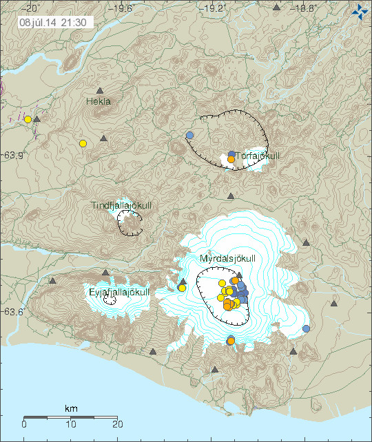
140708_2130
Earthquake activity in Katla volcano during the past 24 hours. Copyright of this image belongs to Icelandic Meteorological Office.

Currently [when I write this text] there is little earthquake activity in Katla volcano. That calm might not last, since earthquake activity has had the pattern of dropping off for few hours between peaks in activity. The largest earthquake during the past 24 hours had the magnitude of 3,0. Smaller earthquakes had the magnitude of 2,7 and lower magnitudes.

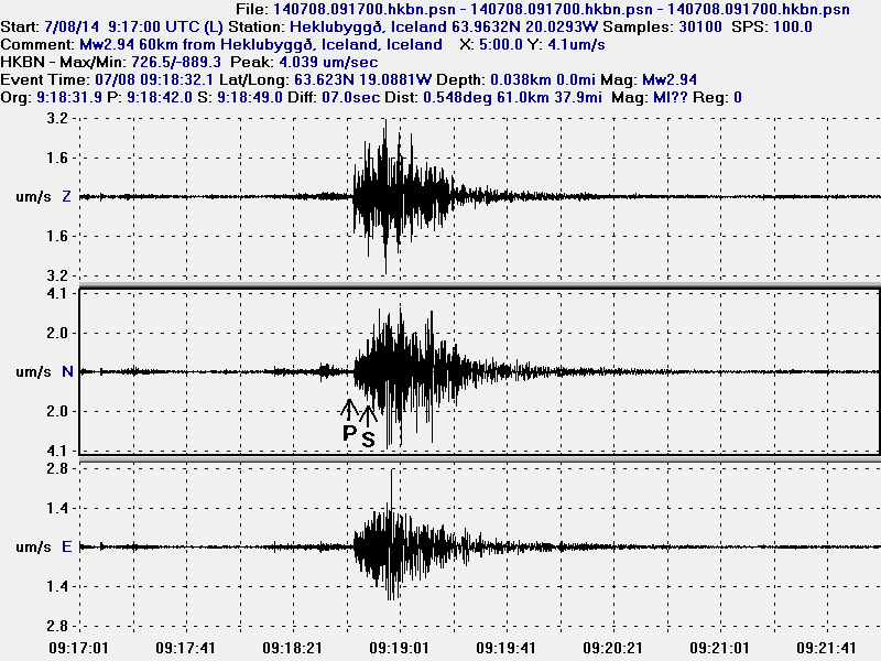
140708.091700.hkbz.psn
The magnitude 3,0 earthquake in Katla volcano this morning at 09:18 UTC. This image is released under Creative Commons licence. Please see CC Licence page for more details.

Earthquake activity has been in the same pattern as did happen in July-2011. So far no harmonic tremor has been detected. It is impossible to know if this is going to result in a eruption or not. The risk of an eruption is higher now then normal, but that does not mean that a eruption is going to take place. It is possible to see larger earthquakes from Katla volcano here on my webicorder website. It is possible to see Katla volcano here if it is not too cloudy.

Donations: Please remember to donate to support my work or buy from Amazon (select your Amazon store before you buy). I am getting awfully broke already (I am just on minimal income from Iceland and that is no good). Thanks for the support.

Update at 21:27 UTC on earthquake activity in Katla volcano

This is a short update on what is now taking place in Katla volcano. This information might go outdated quickly after it is being written.

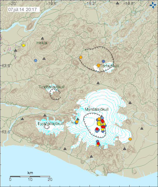
Currently the earthquake activity in Katla volcano is increasing. However there are no signs of imminent eruption as is. However that might change without notice under my current estimate. It is impossible to know if this activity in Katla volcano is going to continue to increase or slow down again. It is my estimate that activity in Katla volcano is going to continue to increase (based on past experience) before it quiets down again. That might not result in a eruption, since this type of activity does not mean that an eruption is going to take place. This activity in Katla volcano has increased that risk at current time and until this earthquake activity stops or gets to lower levels, that risk is going to remain higher then normal. As things stand now there are no signs of that an eruption is going to take place in Katla volcano.

140707_2017
The earthquake activity in Katla volcano during the past 48 hours. Copyright of this image belongs to Icelandic Meteorological Office.

During the minor eruption in Katla volcano in July-2011 (I wrote about it here and here) a minor earthquake swarm like this was also detected in Katla volcano. Back then as now it did start about one month earlier before the minor eruption took place. That activity took place in different part of the caldera then the activity that is now taking place. Today the activity in Katla volcano is the area that might have erupted during the 1918 eruption in Katla volcano (I think).

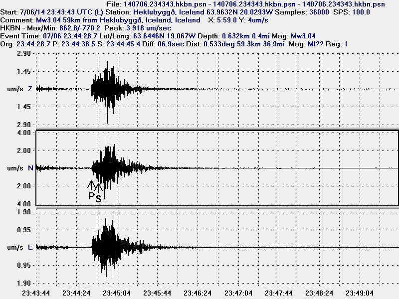
140706.234343.hkbz.psn
The magnitude 3,0 earthquake in Katla volcano yesterday. This image is under Creative Commons licence. Please see CC Licence page for more details.

This earthquake clearly shows the sign of magma under pressure creating a earthquake. This is a possibly a tornillo event. Since it is a low frequency, monochromatic and with long tale in it’s end. I don’t know what is going to happen next in Katla volcano, if anything happens at all other then just this earthquake activity. More water has been reported in Múlakvísl along with higher conductivity taking place, that however might just be rain water in the area since it has been experiencing heavy rain for the past few days. I am going to continue to watch the activity in Katla volcano.

Donations: Please remember to donate to support my work. Thanks for the support.

Ongoing earthquake activity in Katla volcano

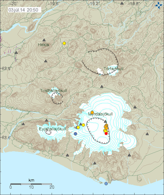
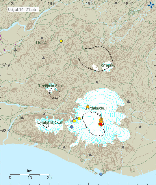
There is currently an ongoing earthquake activity in Katla volcano. So far this earthquake activity has been small in terms of magnitude, with the largest earthquake only having the magnitude of 2,7.

140703_2050
The earthquake activity in Katla volcano. Copyright of this image belongs to Icelandic Meteorological Office.

140703_2155
Updated image of the activity in Katla volcano. Copyright of this image belongs to Icelandic Meteorological Office.

The earthquakes that I have recorded so far are low period earthquake. Suggesting that they are being created due to magma or hydrothermal change inside the volcano. So far nothing suggests that an eruption is imminent. But I find this activity in Katla volcano suspicious and something that needs to watch, since I think this might be a risky situation and it might change on short notice.

Hekla volcano

A magnitude 2,3 earthquake with the depth of 9,9 km took place in Hekla volcano system on 02-July-2014 at 23:48:57 UTC. No other activity took place following this earthquake. It is not clear why this earthquake activity is taking place in Hekla volcano.

Donations:
Please remember to support my work by donations or by shopping on Amazon via the banners that I have here. I get 5% to 10% of each sale made on Amazon if it is trough my banners (what you buy does not matter). Thanks for the support.

Article updated at 22:05 UTC.