Earthquake traces of the magnitude Mw5.6 earthquake

Here are the earthquake traces of the magnitude Mw5.6 earthquake that took place in TFZ on 21.10.2012 at 01:24 UTC. I did detect this earthquake in all of my geophone stations in Iceland.
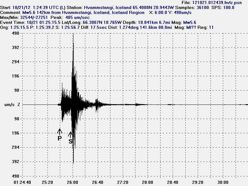

The Mw5.6 earthquake in TFZ. This is the Z trace. This image is released under Creative Commons licence. See licence page for more details.
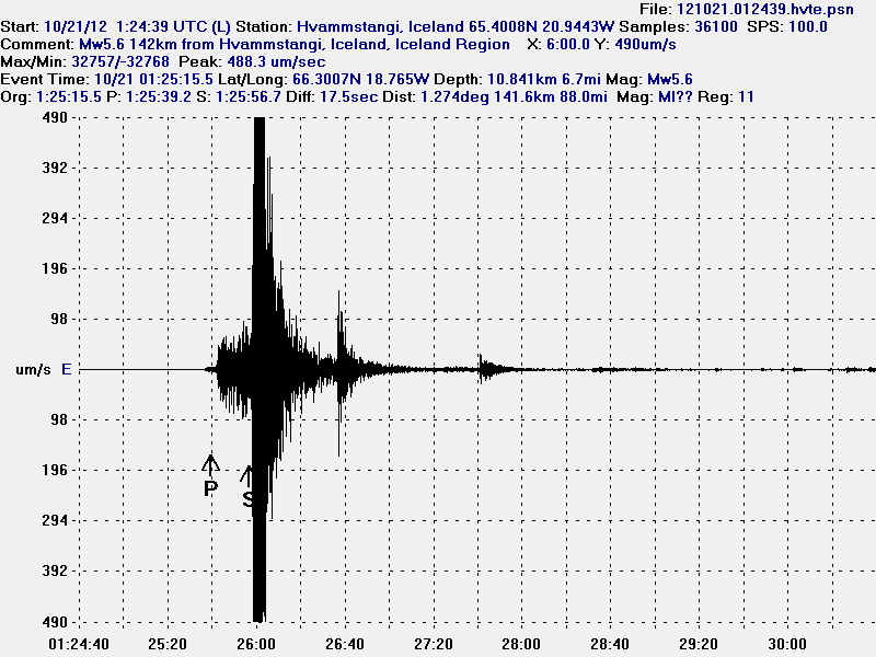

The Mw5.6 earthquake in TFZ. This is the E-W trace. This image is released under Creative Commons licence. See licence page for more details.
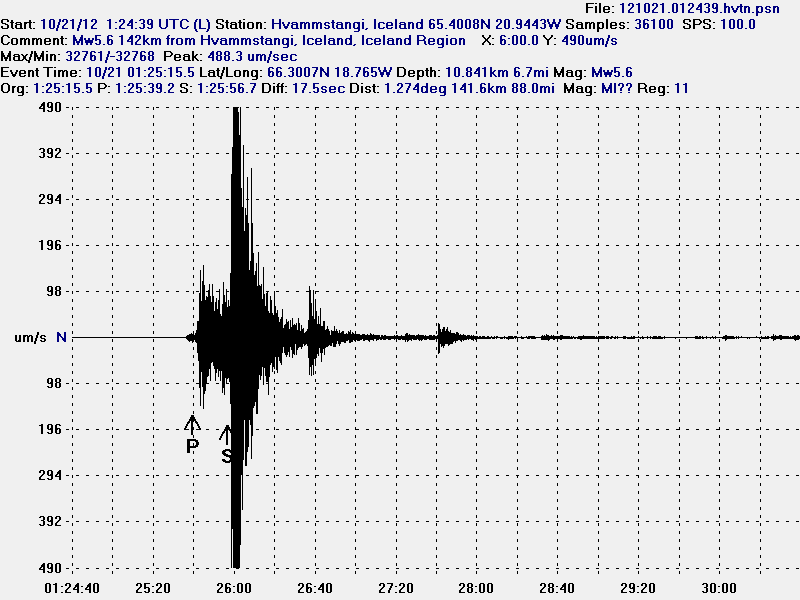

The Mw5.6 earthquake in TFZ. This is the N-S trace. This image is released under Creative Commons licence. See licence page for more details.

The interesting thing about this earthquake is how stronger the N-S,E-W trace is compared to the Z (vertical). This shows that this earthquake movement was strongest on E-W and N-S then vertical (Z).


The Mw5.6 earthquake in TFZ. This is Heklubyggð geophone station. This image is released under Creative Commons licence. See licence page for more details.
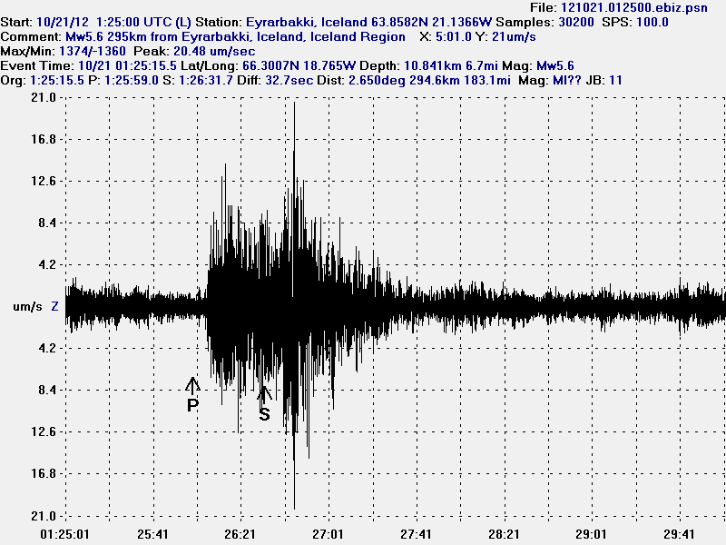

The Mw5.6 earthquake in TFZ. This is Eyrarbakki geophone station. This image is released under Creative Commons licence. See licence page for more details.
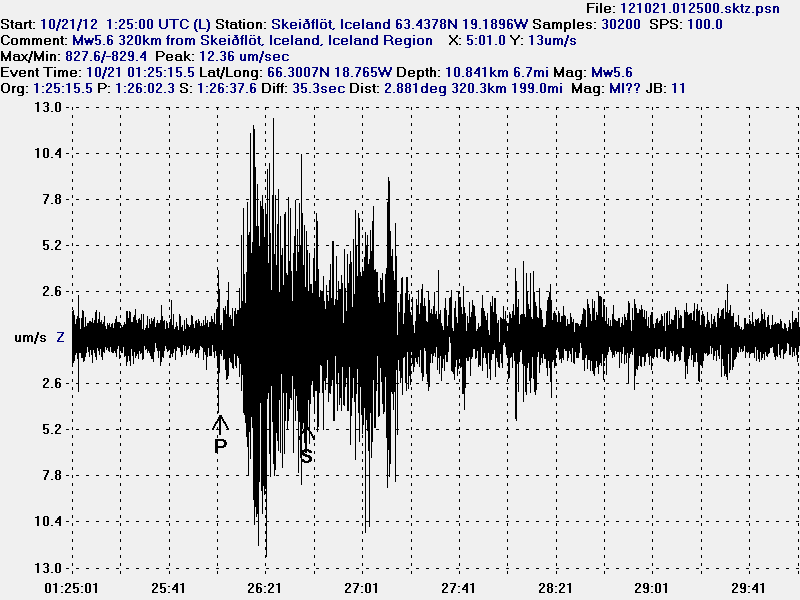

The Mw5.6 earthquake in TFZ. This is Skeiðflöt geohone station. This image is released under Creative Commons licence. See licence page for more details.

Earthquake activity is currently ongoing in TFZ. With earthquakes often reaching magnitude 3.0 in size. But many smaller earthquakes have taken place in the past 10 hours in TFZ. But overall the earthquake activity has slowly been dropping down since the large Mw5.6 took place at 01:24 UTC. If the earthquake activity is going to increase again is impossible to know for sure at current time.

New earthquake magnitude information

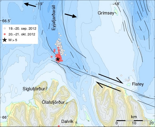
According to news announcement (Icelandic) from Iceland Meteorological Office the largest earthquake in the ongoing earthquake swarm at TFZ had the magnitude of Mb5.6. Currently the earthquake swarm in TFZ is ongoing. This is the largest earthquake in TFZ since the year 1976, when a magnitude 6.2 earthquake did take place not far from Kópasker village.


The star marks the location of the magnitude 5.6 earthquake. The red dots show the current earthquake swarm, the white dots show the earthquake swarm that took place in early September. Copyright of this image belongs to Icelandic Meteorological Office.

The earthquake swarm in this area of TFZ is currently ongoing and does not show any signs for now that it is stopping. But earthquakes with magnitude 3.0 and stronger are still taking place and might still take place in the next few hours tod days. Any strong earthquake is going to appear clearly on my geophone network in Iceland. If anything major happens. I am going to post new blog post about it soon as possible. I update my twitter and Google+ when needed.

TFZ earthquake swarm update at 11:54 UTC

This is short TFZ earthquake swarm update at 11:36 UTC. The strongest earthquake so far was a magnitude Mb5.2. It has been followed by many earthquakes that are 3.0 to 4.8 in magnitude. Number of earthquakes that are below that magnitude is around 300 to 350. But this number is updating constantly so it is going to be outdated once this blog post is up.


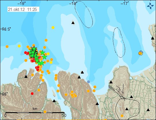
The earthquake area today at 11:25 UTC. The green stars show earthquakes that are above ML3.0 in magnitude. Copyright of this image belongs to Icelandic Meteorological Office.


The tracker showing how dense this earthquake swarm was at times. Copyright of this image belongs to Icelandic Meteorological Office.


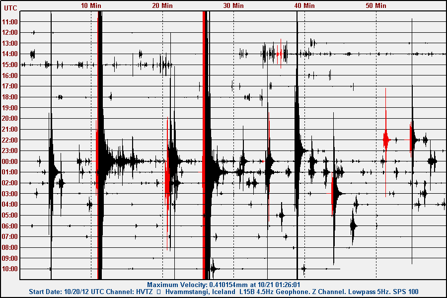
The earthquake swarm on Hvammstangi geophone station. This image is released under Creative Commons licence. See licence page for more details.


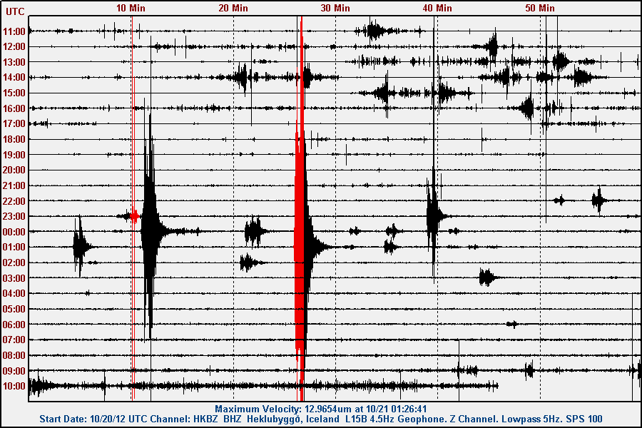
The earthquake swarm on Heklubyggð geophone station. This image is released under Creative Commons licence. See licence page for more details.


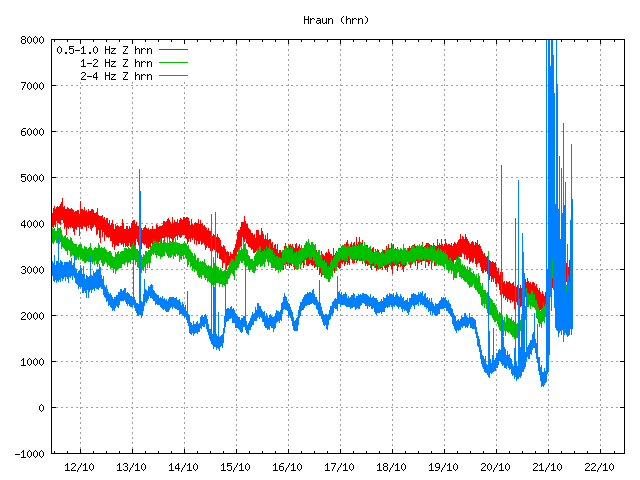
The tremor plot at Hraun á Skaga showing this earthquake swarm clearly. Copyright of this image belongs to Icelandic Meteorological Office.


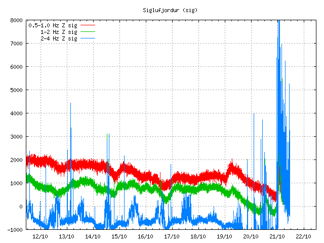
The tremor plot at Siglufjöður. This SIL station is closest to the earthquake swarm. Copyright of this image belongs to Icelandic Meteorological Office.


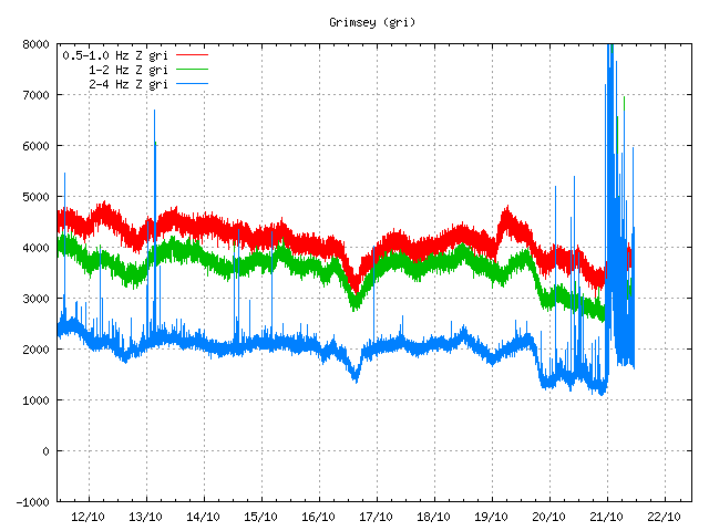
The tremor plot in Grímsey Island. This tremor plot is showing the earthquake swarm clearly. Copyright of this image belongs to Icelandic Meteorological Office.

This earthquake swarm is not over at current time. But earthquake activity has dropped something for the moment.That might change at any time. Since this earthquake swarm does not show any signs of being over at the moment. There is no risk of volcano activity in this area following this earthquake swarm. Since there are no volcanoes in this area of Iceland. This earthquakes are strike-fault earthquakes. I am going to post more updates on this earthquake activity during the day, or when something major happens in this area.

This earthquake swarm has been felt in Siglufjöður town. The largest earthquake was felt over most of north Iceland. Some minor damage has been reported following that earthquake.

Blog post updated at 11:54 UTC on 21.10.2012. Added images that I forgot to add the first time around.

Heavy earthquake activity in TFZ

At the moment there is heavy earthquake activity taking place in TFZ. With earthquakes taking place every second. Strong earthquakes taking place every 2 to 10 minutes. One earthquake has at least reached the magnitude 5.0 and more earthquake with that magnitude is currently taking place on TFZ.

This earthquake activity can be monitored live (5. min, delay) on my geophone network web page here. I am going to post more information when I have more details.

Update 1: According to USGS the largest earthquake had the magnitude of M4.8. I do not know if this is reviewed data or not. USGS data can be viewed here.

Blog post updated at 01:02 UTC on 21.10.2012.