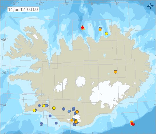
Earlier tonight an earthquake swarm started around 88 km south of a town of Höfn í Hornarfirði. This area last had an earthquake or earthquake swarm in Week 22 (no map exist of it, but the earthquakes are in the weekly overview list) in the year 2007. Then the largest earthquake was around ML3.0 in size.
So far the largest earthquake has been around ML2.3 in size, with the depth of 9.4 km. But the earthquakes that are detected around ML2.0 in size. But given the distance from the SIL network. This size is the lowest size that can be detected from what I can tell. This is because of the distance from the closest SIL station and how few SIL stations are in this area that are able to detect earthquakes this far out in the ocean. Earthquakes like this regularly happen all around Iceland. But most are not detected due to lack of SIL stations in the area. For that reason it is impossible to know for sure how many earthquakes actually have taken place there, as the SIL network is only recording the largest ones in this area.

The area where this earthquake swarm is taking place is on the edge of Iceland volcanic shelf. This is often refereed to as intra-plate earthquakes. Copyright of this picture belongs to Iceland Meteorological Office.
This area is not volcanic last I knew. As it has no-known volcanoes today and most likely never has had any active volcanoes. In this area the Iceland plate is pushing down the oceanic crust that is on top of. This progress often creates earthquakes as we are now seeing. I have not yet found any research paper, as I am unsure what terms to use to look for the research.
