Glacier flood has started in Skaftá river

The latests news is that a glacier flood has started in Skaftá river. At the moment this glacier flood does not appear to be big, as there was also a glacier flood in this river last year. Because of this short time, there has not been a lot of water collected in the western cauldron that is emptying now. It was clear today that it was the western cauldron that had emptied when scientists did fly over the area earlier today.

This glacier flood is often early event and has been since the year 1955. Following this glacier flood there is often spike in harmonic tremor because magma goes on the move due to sudden pressure release in this area. So far it has not been able to trigger a eruption in Hamarinn volcano. It remains to be seen if that has changed or not.

Icelandic News about this

Hlaup hafið í Skaftá (Rúv.is, Pictures, Icelandic)
Rennsli eykst í Skaftá (Vísir.is)
Hlaupið komið í Skaftá (mbl.is)

No glacier flood yet from Hamarinn volcano, but it is on it’s way

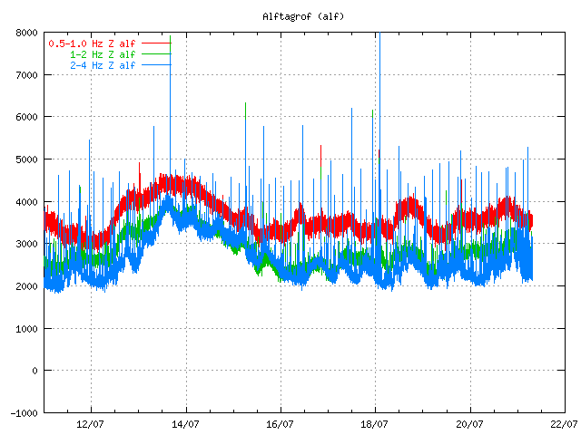
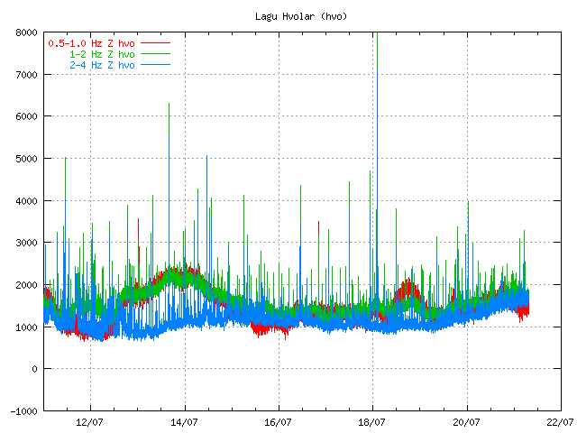
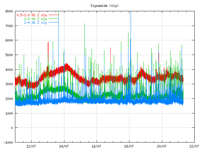
At current time (around 20:30 UTC) it has been observed that no glacier flood has started in Skaftá river. But the glacier flood is expected to start in the river around midnight, but the river might start to grow around 19:00 to 21:00 UTC. According to latest news the river has however started to get darker and conductivity in the water has started rise since this morning, but that was the signal that a glacier flood was about to start. Glacier flood tremor have also been dropping in the last few hours according to the latests news that I have seen (but I am hoping for a update on that detail).

The source of this glacier flood is a hydrothermal area in Hamarinn volcano (part of Bárðarbunga volcano). This area also did have a glacier flood last year. But last year there where two glacier floods in Skaftá river in June 2010, see reports here in Iceland at Icelandic Met Office web page.

This hydrothermal area in Hamarinn volcano is in two cauldrons in the Vatnajökull glacier. With time they fill with water that then breaks ice when the pressure is enough in the cauldrons due to water levels. It remains a question if the surprise glacier flood earlier this month from Hamarinn volcano has something to do with this. But at current time that is only speculation. But if the hydrothermal area is unusually highly active, or there has been some change it is hard to know for sure the size of this glacier flood.

Currently however the experts are expecting a small glacier flood due the fact there where two glacier floods from this area last year. But we however have to wait until midnight until we know what is the actual size of this glacier flood.

Icelandic News about this

Skaftárhlaup ekki enn hafið (Rúv.is)
Skaftárhlaupið komið í byggð eftir sólarhring (Vísir.is)
Engin merki um hlaup ennþá (mbl.is)

Grímsfjall volcano inflates after the large May 2011 eruption

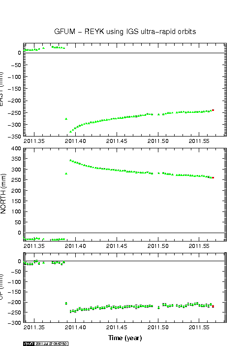
It can be sad that Grímsfjall volcano did not waste any time starting to prepare for next eruption after the large May 2011 eruption. But that eruption was the largest one in at least 140 years or so. This large eruption did mean that there was a large deflation that took place during the eruption. Where the most deflation was around 250mm down, and around 300mm north, and around 350mm east.

Since then Grímsfjall volcano has however been inflating at interestingly high speed. Currently the GPS data shows that it has reached around 250mm east, north and 200mm up since the eruption. But the magma chamber is going to expand horizontal before it expands upwards (think of this in 3D). So it is going to be a while until a inflation upwards is going to be seen.

The GPS data is clear on this as can bee seen here.


Current inflation at 27. July 2011. Copyright of this picture belongs to Icelandic Met Office.

It is hard to know when Grímsfjall volcano is going to erupt next after this big eruption. But it might take few years until we see a new eruption in Grímsfjall volcano.

Earthquake swarm and minor harmonic tremor in Katla volcano

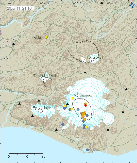
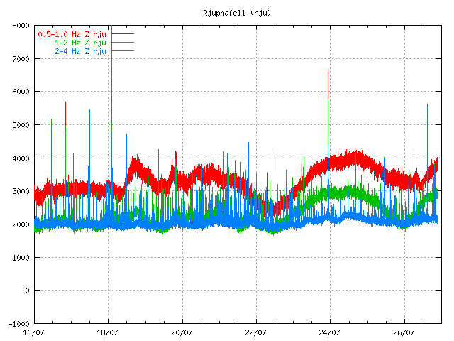
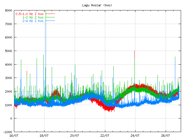
There has been a minor earthquake swarm in Katla volcano today. This earthquake swarm started around 09:00 UTC and lasted with breaks until 14:39 UTC. The largest earthquake in this swarm was ML1.7 with the depth of 3.5 km. Following this earthquake swarm there was a small harmonic tremor spike seen on few SIL stations around Katla volcano. It is unknown at this time if there has been a small glacier flood taking place. But if that is the case, it should be known in the next few hours if that is the case or not.


The earthquake swarm in Katla volcano caldera. Copyright of this picture belongs to Icelandic Met Office.


The harmonic tremor spike can be seen on this SIL station. It is located close to the end of tremor plot. Copyright of this picture belongs to Icelandic Met Office.


The harmonic tremor spike can be seen on this SIL station. It is located close to the end of tremor plot. Copyright of this picture belongs to Icelandic Met Office.

This harmonic tremor is small, but larger then last harmonic tremor that took place in this are about one week ago (far as I can remember). Currently there is nothing that suggests that eruption is imminent. This is just earthquake activity in the same place as it has been for the past five or so weeks.

Sorry for the short blog post. I have gone sick with some cold. No advice needed on how to get rid of it. That is going to take few days on it’s own.

Currently all is quiet in Iceland

At the moment it is rather quiet in Iceland in earthquakes and volcanoes. When that might change is impossible to say. But in the last few days there have been minor earthquake swarms on the Reykjanes Ridge. It is not related to volcanism, but rather tectonic movement along the rift zone.

There is continued minor earthquake swarm activity in Katla volcano. But it has quieted down from about two weeks ago. For the moment, the glacier floods seems to have stopped.

Other then this minor earthquake activity, everything is quiet in Iceland.

Small glacier flood from Mýrdalsjökull glacier (Katla volcano)

During the night (and when I had unstable power) there was a small glacier flood from Mýrdalsjökull volcano. Some minor harmonic tremor change was detected following this glacier flood. This even was small one, many times smaller then what did happen on the 8 to 9 July 2011. Due to security concerns the Civil Emergency Authority did close the main road in Iceland for this area. Since they never know how big the flood can actually be. The main road was closed for about one hour. This glacier flood was detected around midnight 20 to 21 July 2011.

This flood is actually so small it is hard to see it on the harmonic tremor plot from the SIL stations around Katla volcano.


Tremor plot from 07:50 UTC this morning. It is hard to see the harmonic tremor from this minor glacier flood. Copyright of this image belongs to Icelandic Met Office.


Tremor plot from 07:50 UTC this morning. It is hard to see the harmonic tremor from this minor glacier flood. Copyright of this image belongs to Icelandic Met Office.


Tremor plot from 07:50 UTC this morning. It is hard to see the harmonic tremor from this minor glacier flood. Copyright of this image belongs to Icelandic Met Office.

What happens next is impossible to know for now. But it seems that activity continues to be high in Katla volcano. All that can be done is to wait and see what happens. But I am going to continue to monitor the changes in Katla volcano as best that I can do until I finish my summer job (29. July).

Icelandic News about this.

Aukin leiðni í Múlakvísl og órói í Mýrdalsjökli (Vísir.is, Icelandic)
Náið fylgst með Mýrdalsjökli (mbl.is, Icelandic)
Hringvegurinn opinn á ný (Rúv.is, Icelandic)
Breytingar í Múlakvísl (Rúv.is, Icelandic)

Interesting earthquake activity in Katla volcano

Sometimes there is a strange earthquake activity in volcanoes. I do think that this qualifies as one of that cases. But there has been odd and what appears to be grown earthquake activity in SE part of the caldera rim in Katla volcano.
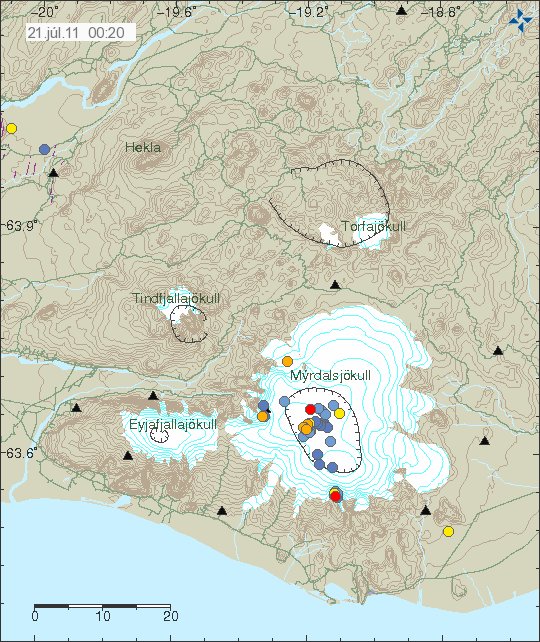

The earthquake activity is the earthquake spot the SE in Katla volcano, out side the caldera. Copyright of this picture belongs to Icelandic Met Office.

From what I can gather this activity started in Week 27 or about that time. Since then it appears to have been growing in number of earthquakes. I do not know yet if there have been any changes in the area, like hydrothermal activity.
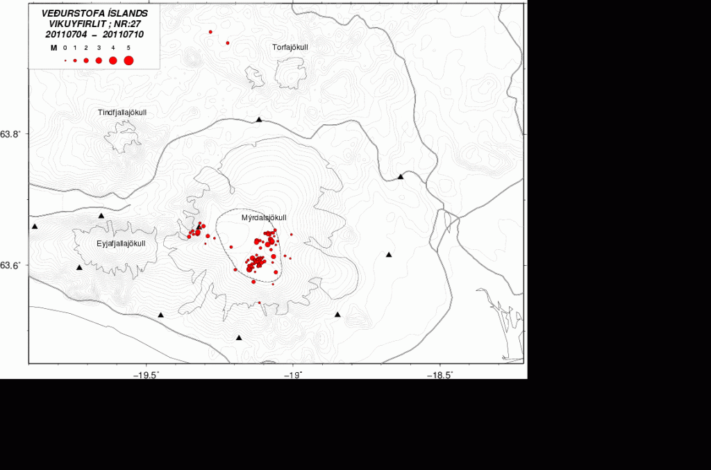

Week 27. One earthquake can be seen in this area. Copyright of this picture belongs to Icelandic Met Office.
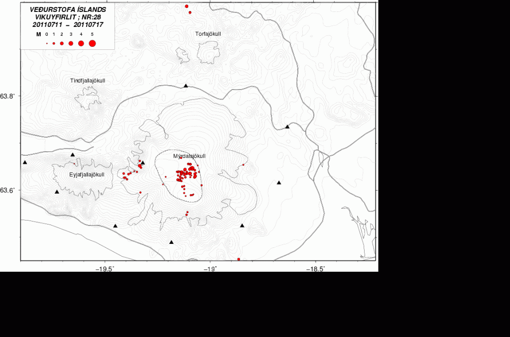

Week 28. More earthquakes in the same area. Clear sign that the activity is growing. Copyright of this picture belongs to Icelandic Met Office.
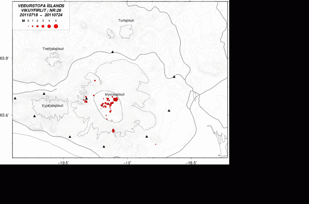

Weeek 29 (crurrent week) . Even more earthquakes at the same location. Copyright of this picture belongs to Icelandic Met Office.

While I do not yet what is going on there. This is something that might be interesting to watch and see what happens. Because small amount of magma might just have found a new pathway up the surface in this area. Even if it does not erupt, this might create new hydrothermal area if this is in fact magma. But given that this is in a volcano and really dense earthquake swarm. It is my guess that it is the case.

Power outage: Due to some maintenance work on the local power grid where I live I lost all power from 01:00 until about 06:20 UTC this morning. But that means that this blog post is late by several hours and my geophone webicorders have been off-line at the same time. Sadly I cannot afford few UPS like this one to keep my system up and running when the power goes out. As I need at least four of them at home and one with each webicorder computer (at location).

I am going to post update on what did happen during the night around 09:00 08:00 UTC. When I know more and after some more sleep.

Blog post updated at 07:29 UTC on 21. July 2011.

New cauldrons forms in Mýrdalsjökull glacier (Katla volcano)

According to the news here in Iceland there have been a formation of at least three new cauldrons in Mýrdalsjökull glacier, where they have not been before in the glacier. But this means that the hydrothermal areas under the glacier are growing in size due to new magma pushing up into the crust and warming it up.

This has been revealed after a daily checking of the status on the glacier. But the current cauldrons that formed on the 8 and 9th July have also deepened according to the same news. A lot of deep cracks are also forming in Mýrdalsjökull glacier. Making the south part of the glacier extremely dangerous at current moment.

There is also risk of minor glacier flood from water collecting under the glacier (both really small and slightly larger ones). But water might be collecting in ice-caves under the glacier and break free without any warning at all. The Civil Emergency Authority in Iceland warn against travelling in this area on Mýrdalsjökull glacier.

The reason why this is happening is the fact that hydrothermal activity is increasing under Mýrdalsjökull glacier in Katla volcano. But this is a clear sign that Katla volcano is warming up to a eruption. When that might happen is still a question with no answers.

Currently there is no good way to know what happens in regards to possible glacier floods due to this increased hydrothermal activity in Katla volcano. But floods are expected to take place without any warning now in this area.

Icelandic News with pictures of the cauldrons.

Þrýstingur fellur í sigkötlunum (Rúv.is, Picture)
Ferðamenn koma ekki nálægt sigkötlum (Vísir.is, Icelandic, Picture)
Ferðamenn aka ofan í ketil sem er að springa (Vísir.is, Icelandic, Picture)
Ástæða til að vakta svæðið (mbl.is, Icelandic, Picture)
Sigkatlasvæðið er varasamt (mbl.is, Icelandic)
Sigkatlasvæðið stækkað (mbl.is, Icelandic, Picture)

Blog post updated at 00:51 UTC 20. July 2011.

Small earthquake swarm in Katla volcano caldera

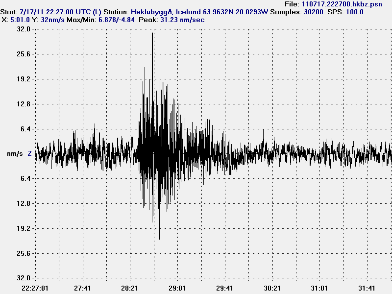
At the moment there appears to be a small earthquake swarm in Katla volcano. Currently this is just a earthquake swarm. All the tremor plots are normal and show no signs of harmonic tremors and magma on the move. The largest earthquake in this earthquake swarm in inside Katla volcano caldera was a ML1.3 with the depth of 1.7 km according to reviewed data from Icelandic Met Office.


The earthquake swarm in Katla voclano. It is deep inside Katla volcano caldera as can clearly be seen. Copyright of this picture belongs in Icelandic Met Office.


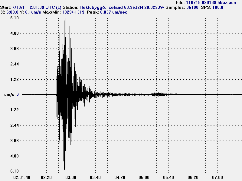
The ML1.3 earthquake as I did record it on my Heklubyggð geophone. Given the shape and how low period this earthquake is. I would say that it was created by magma pushing upwards in the crust inside Katla volcano caldera. This picture is released under Creative Commons licence, see the licence web page for more details.

At the moment (when this is written) it seems that this earthquake swarm is over. For the moment anyway. But it hard to know for sure if it resumes or something else starts in Katla volcano.

Update 1: A earthquake with the magnitude ML3.8 did happen in Katla volcano caldera at 02:02 UTC. Following this earthquake there have been many aftershocks. It is not yet clear if this means that Katla volcano is starting a eruption or not. But that should be clear in few hours if that is the case or not.


The ML3.8 earthquake that happened at 02:02 UTC. This is by the automatic SIL system, so it’s size can change. This picture is released under Creative Commons licence, see the licence web page for more details.


The location of the ML3.8 earthquake in Katla volcano caldera and the following aftershocks. Copyright of this picture belongs to Icelandic Met Office.

Blog post updated at 02:26 UTC on 18. July 2011.
Blog post updated at 02:40 UTC on 18. July 2011.

1 million views on this blog

This blog has reached a important milestone. It has had this many views in less then 1 year since I did start it. But I did start this blog in September 2010. Few months after Eyjafjallajökull volcano eruption.

Here is the latest number from my web counter: 1,001,099

I want to say thank you to all of you how read this blog. But this many readers make this blog worth it in so many ways.