Sharp rise in harmonic tremor on Skrokkalda and Grímsfjall SIL station (among others)

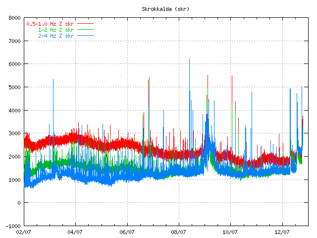
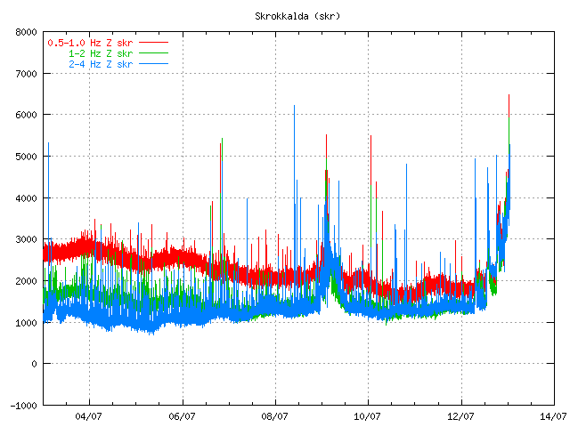
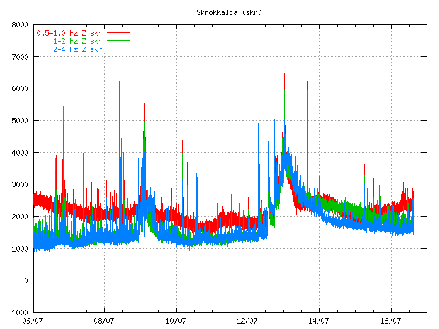
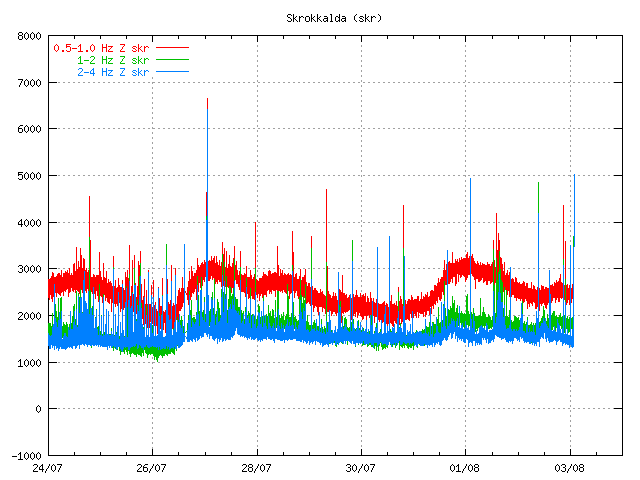
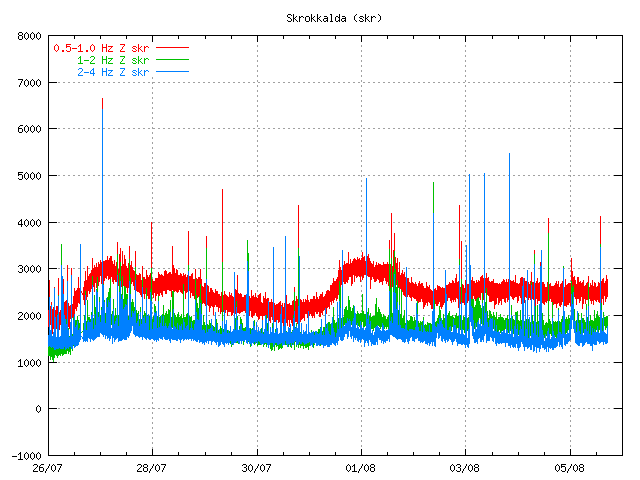
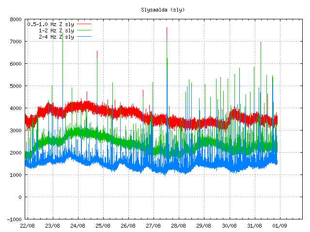
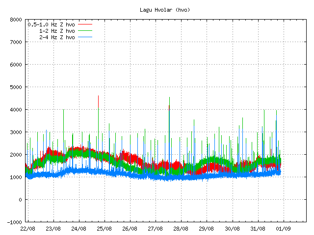
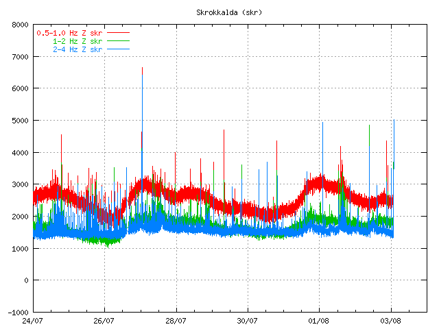
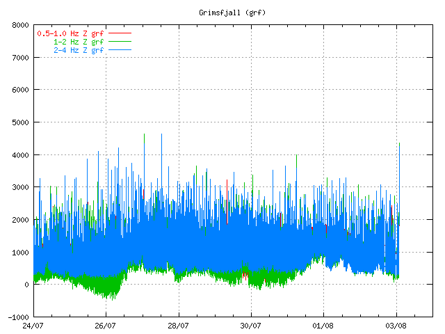
There is a sharp rise in harmonic tremor on the Skrokkalda and Grímsfjall SIL station. I do not know yet what volcano is responsible for it. But the Hamarinn volcano is a suspect at the moment.

Current tremor plot.


The tremor spike is at the end of this tremor plot. Copyright of this picture belongs to Icelandic Met Office.
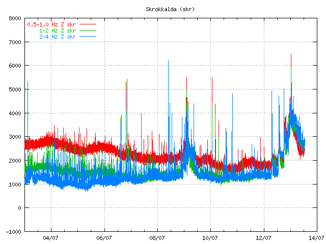

The tremor spike is at the end of this tremor plot. Copyright of this picture belongs to Icelandic Met Office.

I am going to post more information about what is going on when I know more. This blog post might get updated soon if needed.

Grímsfjall volcano inflates after the large May 2011 eruption

It can be sad that Grímsfjall volcano did not waste any time starting to prepare for next eruption after the large May 2011 eruption. But that eruption was the largest one in at least 140 years or so. This large eruption did mean that there was a large deflation that took place during the eruption. Where the most deflation was around 250mm down, and around 300mm north, and around 350mm east.

Since then Grímsfjall volcano has however been inflating at interestingly high speed. Currently the GPS data shows that it has reached around 250mm east, north and 200mm up since the eruption. But the magma chamber is going to expand horizontal before it expands upwards (think of this in 3D). So it is going to be a while until a inflation upwards is going to be seen.

The GPS data is clear on this as can bee seen here.


Current inflation at 27. July 2011. Copyright of this picture belongs to Icelandic Met Office.

It is hard to know when Grímsfjall volcano is going to erupt next after this big eruption. But it might take few years until we see a new eruption in Grímsfjall volcano.

Small glacier flood from Mýrdalsjökull glacier (Katla volcano)

During the night (and when I had unstable power) there was a small glacier flood from Mýrdalsjökull volcano. Some minor harmonic tremor change was detected following this glacier flood. This even was small one, many times smaller then what did happen on the 8 to 9 July 2011. Due to security concerns the Civil Emergency Authority did close the main road in Iceland for this area. Since they never know how big the flood can actually be. The main road was closed for about one hour. This glacier flood was detected around midnight 20 to 21 July 2011.

This flood is actually so small it is hard to see it on the harmonic tremor plot from the SIL stations around Katla volcano.


Tremor plot from 07:50 UTC this morning. It is hard to see the harmonic tremor from this minor glacier flood. Copyright of this image belongs to Icelandic Met Office.


Tremor plot from 07:50 UTC this morning. It is hard to see the harmonic tremor from this minor glacier flood. Copyright of this image belongs to Icelandic Met Office.


Tremor plot from 07:50 UTC this morning. It is hard to see the harmonic tremor from this minor glacier flood. Copyright of this image belongs to Icelandic Met Office.

What happens next is impossible to know for now. But it seems that activity continues to be high in Katla volcano. All that can be done is to wait and see what happens. But I am going to continue to monitor the changes in Katla volcano as best that I can do until I finish my summer job (29. July).

Icelandic News about this.

Aukin leiðni í Múlakvísl og órói í Mýrdalsjökli (Vísir.is, Icelandic)
Náið fylgst með Mýrdalsjökli (mbl.is, Icelandic)
Hringvegurinn opinn á ný (Rúv.is, Icelandic)
Breytingar í Múlakvísl (Rúv.is, Icelandic)

New cauldrons forms in Mýrdalsjökull glacier (Katla volcano)

According to the news here in Iceland there have been a formation of at least three new cauldrons in Mýrdalsjökull glacier, where they have not been before in the glacier. But this means that the hydrothermal areas under the glacier are growing in size due to new magma pushing up into the crust and warming it up.

This has been revealed after a daily checking of the status on the glacier. But the current cauldrons that formed on the 8 and 9th July have also deepened according to the same news. A lot of deep cracks are also forming in Mýrdalsjökull glacier. Making the south part of the glacier extremely dangerous at current moment.

There is also risk of minor glacier flood from water collecting under the glacier (both really small and slightly larger ones). But water might be collecting in ice-caves under the glacier and break free without any warning at all. The Civil Emergency Authority in Iceland warn against travelling in this area on Mýrdalsjökull glacier.

The reason why this is happening is the fact that hydrothermal activity is increasing under Mýrdalsjökull glacier in Katla volcano. But this is a clear sign that Katla volcano is warming up to a eruption. When that might happen is still a question with no answers.

Currently there is no good way to know what happens in regards to possible glacier floods due to this increased hydrothermal activity in Katla volcano. But floods are expected to take place without any warning now in this area.

Icelandic News with pictures of the cauldrons.

Þrýstingur fellur í sigkötlunum (Rúv.is, Picture)
Ferðamenn koma ekki nálægt sigkötlum (Vísir.is, Icelandic, Picture)
Ferðamenn aka ofan í ketil sem er að springa (Vísir.is, Icelandic, Picture)
Ástæða til að vakta svæðið (mbl.is, Icelandic, Picture)
Sigkatlasvæðið er varasamt (mbl.is, Icelandic)
Sigkatlasvæðið stækkað (mbl.is, Icelandic, Picture)

Blog post updated at 00:51 UTC 20. July 2011.

Small earthquake swarm in Katla volcano caldera

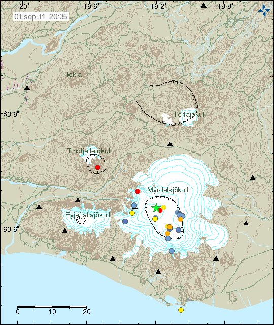
At the moment there appears to be a small earthquake swarm in Katla volcano. Currently this is just a earthquake swarm. All the tremor plots are normal and show no signs of harmonic tremors and magma on the move. The largest earthquake in this earthquake swarm in inside Katla volcano caldera was a ML1.3 with the depth of 1.7 km according to reviewed data from Icelandic Met Office.


The earthquake swarm in Katla voclano. It is deep inside Katla volcano caldera as can clearly be seen. Copyright of this picture belongs in Icelandic Met Office.


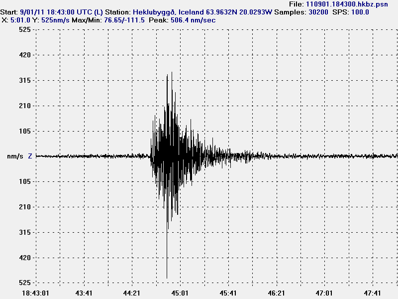
The ML1.3 earthquake as I did record it on my Heklubyggð geophone. Given the shape and how low period this earthquake is. I would say that it was created by magma pushing upwards in the crust inside Katla volcano caldera. This picture is released under Creative Commons licence, see the licence web page for more details.

At the moment (when this is written) it seems that this earthquake swarm is over. For the moment anyway. But it hard to know for sure if it resumes or something else starts in Katla volcano.

Update 1: A earthquake with the magnitude ML3.8 did happen in Katla volcano caldera at 02:02 UTC. Following this earthquake there have been many aftershocks. It is not yet clear if this means that Katla volcano is starting a eruption or not. But that should be clear in few hours if that is the case or not.


The ML3.8 earthquake that happened at 02:02 UTC. This is by the automatic SIL system, so it’s size can change. This picture is released under Creative Commons licence, see the licence web page for more details.


The location of the ML3.8 earthquake in Katla volcano caldera and the following aftershocks. Copyright of this picture belongs to Icelandic Met Office.

Blog post updated at 02:26 UTC on 18. July 2011.
Blog post updated at 02:40 UTC on 18. July 2011.

Small harmonic tremor spike from Hamarinn volcano

There seems to be a small harmonic tremor spike taking place in Hamarinn volcano (Bárðarbunga volcano) at the moment. This tremor spike is not strong at the moment. This tremor spike appears to have been pre-seeded by few long period earthquakes (not all of the earthquakes seen on Skrokkalda are from Hamarinn volcano, few are from Katla volcano), but that suggests that magma is on the move in Hamarinn volcano. But this would the second harmonic tremor in a time period of 48 hours it seems.


The harmonic tremor spikes can be seen at the end of this tremor plot. Copyright of this picture belongs to Icelandic Met Office.

Currently it is impossible to know what happens in Hamarinn volcano. As it’s pre-eruption behaviour is rather unknown. But if there is a eruption in this area I am expecting a lot of earthquakes, with size well over ML3.0.

Blog post updated at 16:20 UTC.

Possible minor eruption in Hamarinn volcano yesterday. Update on Katla volcano

There appears to be more in this new hydrothermal activity in Hamarinn volcano then at first sight. It seems that this actually might have a eruption in Hamarinn volcano (Bárðarbunga volcano). If this event is confirmed, this is the first eruption in Hamarinn volcano since the year 1910.

This also mean that there is a chance of more activity in this area in coming weeks or months. But when it might happen is impossible to know.


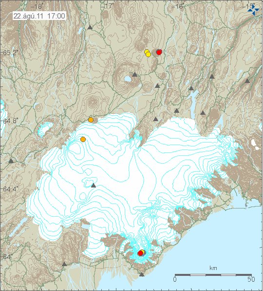
The new cauldrons are marked with a “X” on this map. Copyright of this picture belongs to Icelandic Met Office.

This eruption was really small and did just last for few hours. But it was able to melt a lot of ice and create rather large glacier flood from Vatnajökull glacier. If the activity resumes in this area this is going to repeat it self in terms of glacier flood.

Icelandic News about this event.

Innskot af kviku (Rúv.is, Icelandic)
Eldgos gæti hafa brotist upp við Hamarinn (Vísir.is, Icelandic, Pictures)
Fundu nýjan sigketil (mbl.is, Icelandic, Pictures)

Sigketill við Lokahrygg (Icelandic Met Office, Icelandic, Pictures)

Update on Katla volcano

Here is a short update on Katla volcano. There have been repeated short burst of harmonic tremors taking place inside the Katla volcano caldera. This harmonic tremor spikes have been small and they are hard to see on the harmonic tremor graph that Icelandic Met Office has on-line. Other then this it has been quiet so far in Katla volcano.

New hydrothermal area found in Vatnajökull glacier

After the glacier flood that took place last night and today the source of this flood has finally been found. According to the news the source of this flood is a new hydrothermal area inside the Bárðarbunga fissure swarm. But this new hydrothermal area is located in Hamarinn volcano (also known lokahryggur or Loki-fögrufjöll), sadly the news does not say exactly where it is located. Just that it located in western Vatnajökull glacier. This flood did go down the river Sveðju and into the Hágöngulón lake (human made lake) that did swallow it whole according to the news. The overflow after the dam lake was full did go into an even larger natural lake, that did not feel any effects of this glacier flood.

In terms of size this glacier flood was larger then the glacier flood in Mýrdalsjökull glacier last week. But that was only about 2000 m3/sec, but this was somewhere around 2200 m3/sec. But this are the numbers that I have seen in the news. But this are not confirmed numbers and might be subject to change on later date.

Other then this activity. It has been rather quiet in Iceland in terms of earthquake and volcano activity.

Icelandic news about this.

Áður óþekkt jarðhitasvæði fundið (Rúv.is, Icelandic)
Virkjunarlónin gleyptu gríðarstóra flóðbylgjuna (Vísir.is, Icelandic)

Órói við Lokahrygg í Vatnajökli (Icelandic Met Office, Icelandic, Pictures)

Glacier flood confirmed from Vatnajökull glacier, flood is from Hamarinn volcano (Loki-Fögrufjöll area)

The harmonic tremor that started yesterday has been confirmed to be coming from Hamarinn volcano (Bárðarbunga volcano), but they are also known as Loki-Fögrufjöll in GVP database.

So far there is nothing that indicates an eruption is taking place at the moment in Hamarinn volcano. But that might change without warning. At the moment nobody is sure where the glacier flood is coming from. But this appears to be a new area of hydrothermal activity in Hamarinn volcano that is releasing water at the moment. This new hydrothermal area is most likely created by new dike intrusions into the bed rock in the affected area. There are no pictures of the affected area, as the area is impassible to air plains at the moment due to cloud cover or fog. Lack of earthquakes also makes it hard to locate the source of this glacier flood.

Currently the glacier flood has peaked and is getting lower. There not expected to be any damage from this glacier flood on human structures or roads. This area of Iceland is unpopulated. The water is going into large lakes in the area where the effects of this glacier flood are almost none. The glacier flood did flow into a dam lake that is collecting water from rivers that this glacier flood did go into. This did make the lake rise about 70 cm in several hours and fill it. No damage is expected from this glacier flood to the dam or other structures in this area connected to the dam. But it is estimated that 26 gigaliters did flow into the dam lake during the night from this glacier flood.


Harmonic tremor at 12:59 UTC, this is Skrokkalda SIL station. At this time it had been dropping down. But starting to rise again after that when this is written. Copyright of this picture belongs to Icelandic Met Office.


This is the harmonic tremor at 12:59 UTC on Grímsfjall SIL station. It is bit hard to see it due high background noise on this SIL station. Copyright of this picture belongs to Icelandic Met Office.

So far this is just a glacier flood and nothing else. But that might change if an eruption starts in this area. But that is no way certain that it is going to happen now. We just have to wait and see what happens in Hamarinn volcano.

Icelandic News about this.

Hágöngulón fylltist í hlaupinu (mbl.is, Icelandic)
Hlaup undan Köldukvíslarjökli (mbl.is, Icelandic)
Jökulhlaup undan Vatnajökli (Vísir.is, Icelandic)
Hlaupið í rénun (Vísir.is, Icelandic)
Órói við Vatnajökul (Rúv.is, Icelandic)
Flóð undan Vatnajökli (Rúv.is, Icelandic)

New harmonic tremor detected. But it is not from Katla volcano

Some other and unknown volcano dedicated to join the spotlight in Iceland by starting making it’s own harmonic tremor. I do not yet know what volcano this is. But most likely it is the Hamarinn volcano. But that is part of Bárðarbunga volcano.


Skrokkalda SIL stations 07:49 UTC this morning. The first harmonic tremor spike seen on that SIL station. Copyright of this image belongs to Icelandic Met Office.


Skrokkalda SIL station 19:09 UTC. The third harmonic tremor spike in progress when this graph was saved. Copyright of this image belongs to Icelandic Met Office.

I do not know what volcano is making this noise since there are no earthquakes. But I now find this most likely to be an dike intrusion somewhere close to Skrokkalda SIL stations. Other volcanoes that might be creating this harmonic tremor is the volcano Tungnafellsjökull volcano or the volcano that Skrokkalda SIL station actually is on top of.

But both of those volcanoes have been dormant for an long time now. So I find that to be unlikely, but not impossible. Until a earthquakes happens or something else that actually shows the area of activity in question. This is all just a guess work out in the blue.

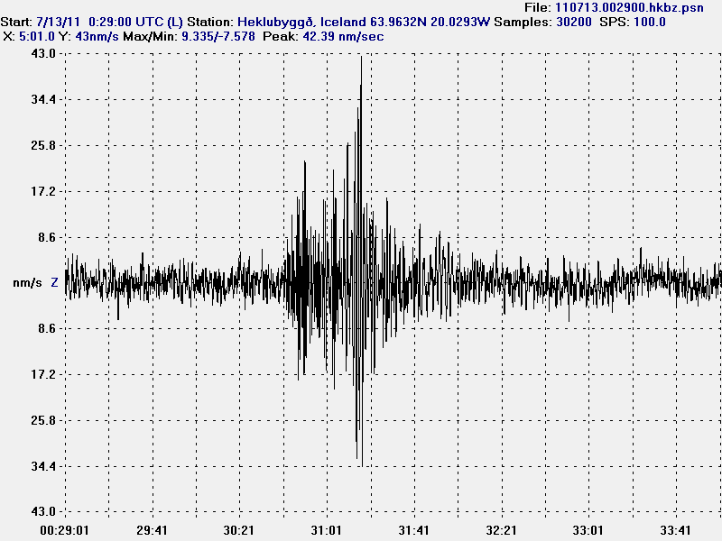
Update 1: There is more going on there now then when this first did start. I did record an earthquake from this harmonic tremor around 00:30 UTC. This earthquake was extremely low period as can be seen on this picture.


This earthquake took place around 00:30 UTC on 13. July 2011. It is filtered at 1Hz and is extremely long period earthquake. This suggests that magma did create this earthquake. This picture is released under Creative Commons Attribution-ShareAlike 3.0 Unported License. See the Creative Commons Licence web page for more information.

Blog post updated at 01:02 UTC on 13. July 2011.