Donation note: I still need donations to survive this month as any other months while I am just on social welfare from Iceland as I have explained here. This month I just have around 24 DKK (3.21€) for food this month after paying all the bills and my debt. I have already got some donation, but they just allow me to buy food for about one and half week if I am smart. Thanks for the help.
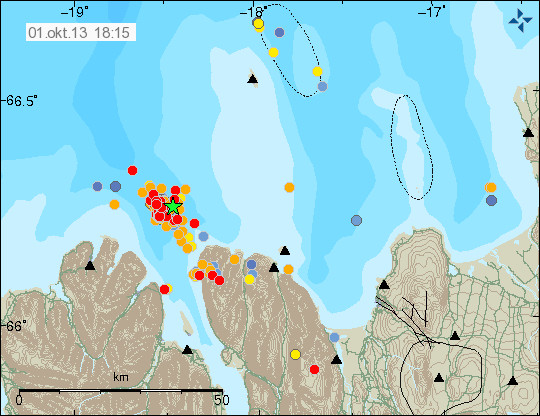
The earthquake swarm on Tjörnes Fracture Zone continues. The earthquakes are getting stronger, with the largest one today having the magnitude 3.8 (automatic results) and five other earthquakes with the magnitude 3.0 to 3.2. Currently the depth is around the same, it remains at 5 to 15 km and at the moment it doesn’t seems to be changing. Rate of earthquakes is around the same today (02-October-2013) as it was yesterday (01-October-2013), with no major changes in earthquake rate from what I can see currently taken place.
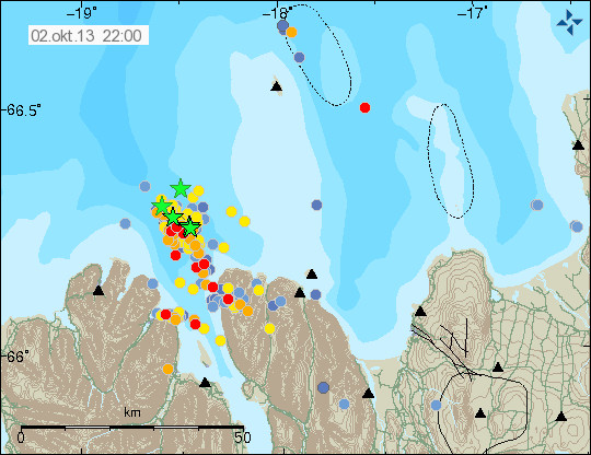
Earthquake activity in Tjörnes Fracture Zone. Green star show earthquakes larger than magnitude 3.0. Copyright of this image belongs to Icelandic Meteorological Office.
All earthquakes above magnitude 3.0 have been felt in Siglufjöður and Ólafsfjörður towns and other populated areas that are close to this earthquake swarm. There are no signs of this earthquake swarm slowing down as is. It still has not been confirmed if this earthquake activity is connected to magma injection at depth, or if this is just normal tectonic earthquake activity in this area. It’s going to remain difficult to confirm this idea until an eruption starts in this area and that simply might just not happen at all. The largest earthquakes appear on my webicorders website here, on the geophone station named Böðvarshólar.
Blog post updated at 22:33 UTC on 02-October-2013.
Blog post updated at 22:39 UTC on 02-October-2013.