Earthquake swarm on the Reykjanes ridge

Today (13-April-2014) an earthquake swarm started on the Reykjanes Ridge. The earthquake swarm is taking place not far from Geirfuladrangi that is an ocean rock in this area. It is only occupied by birds during the summer. This rock was formed in an eruption at this location some 300 to 700 years ago. I am not sure exactly what year that did happen. This is the second earthquakes swarm taking place at this location this month with last earthquake swarm taking place in this location on 4-April-2014 as can be seen here.

140413_1530
The earthquake swarm on the Reykjanes ridge. Copyright of this image belongs to Icelandic Meteorological Office.

Largest earthquakes have had the magnitude around 3,0 and above. Due to distance from the SIL network there magnitude is being underestimated by the automatic calculations in the SIL network. It is possible to see the earthquake appear on my geophone network here (the two stations I still have up and running in Iceland). The earthquake swarm is currently ongoing, it however drops in activity for shorter and longer period of time. I don’t know if this is due to tectonic movements or magma movement in the volcano that is at this location. So far I have not seen any signs of eruption on nearby SIL stations.

Hard drive update: I am now up and running (mostly) since I got new hard drive earlier this week. It appears that I might have lost some data. I am not sure how much data was lost. But it might have just been an minor data loss from the looks of it. Few earthquakes pictures of activity in early April-2014. This data loss was due to bad sectors on my old hard drive and the lost data cannot be recovered.

Google Adsense: As all “goodmonopoly Google Adsense has close to zero help service when it comes solving issues with Google Adsense accounts. Currently my Google Adsense account is in some type of enabled or disabled state (I don’t know and information about the problem is limited to none, even if I have asked for help on this issue). I am not sure what is going to happen with my Google Adsense account. I am not sure if I am going to try and enable it soon, since that might not work at all. I am not just sure what happens if I try again since this process at Google Adsense is about 90% automatic and done with robots rather than humans.

Amazon Advertisements: Since I don’t have Google Adsense advertisements (at the moment anyway). I am going to use Amazon Advertisements and try to earn some income from them. However there is an difference between Google and Amazon. The difference is that Amazon advertisements are not CPI advertisements or CPC/PPC advertisements.

With Amazon Advertisement I get 5 to 15% of the price of each item sold on Amazon via my banners that I have up here. Each click is valid for 90 days (it used to be like that) according to Amazon FAQ (UK. US FAQ can be found here) on the income aspect of Amazon Advertisements.

Earthquake swarm on Reykjanes ridge

During the night (4-April-2014) an earthquake swarm took place on the Reykjanes Ridge. Largest earthquake in this swarm had the magnitude of 3,5 and was felt on land according to information from Icelandic Meteorological Office. This earthquake swarm might still be ongoing, but it only lasted for about 1 hour last night. That is not really long period of activity for an earthquake swarm in this area. It is possible to monitor the earthquake here on my webicorder website. I am going to remove the test card images once I have my Gentoo Linux up and running in few days time.

140404_1805
The earthquake swarm on the Reykjanes Ridge. Green stars mark earthquakes with magnitude larger than 3,0. Copyright of this image belongs to Icelandic Meteorological Office.

Unconfirmed information in news on Rúv.is suggest that this earthquake swarm might have its origin in magma movement at this location. Rather than tectonic activity at the same area. This area often has powerful earthquake swarms. Earthquake swarms in this area often drop in activity for few to several days at the time, before they resume at even more powerful then before. I don’t know if that is going to happen now, there is an good chance that is going to happen now or this might just be it. All that can is possible to do at the moment is to wait and see what happens next.

Update on the hard drive saga: So I did buy a new hard drive. When I did try to use it I found out that the drive I had bought was faulty from the factory. The store has already ordered an replacement hard drive and I should get it on Monday. I hope this issue is resolved by then. I have already received donations to support buying this new hard drive. But that does not mean my financial status is good this month. But it is far better now than in April or the months before it. Thankfully. Thanks for the support. I am currently using my Windows XP (normally just used to play games) hard drive to write this while my Gentoo Linux is out of commission due the hard drive failure.

Earthquake activity in Hekla volcano continues

Today (27-March-2014) during the night three earthquakes took place in Hekla volcano. This were typical earthquakes and like those that have been taking place earlier in March. What this earthquake activity means I do not yet know. The magnitude of this earthquakes was in the range of 0,7 to 0,8 with the depth of 9,7 to 8,3 km.

140327_2100
The earthquakes in Hekla volcano system. Copyright of this image belongs to Icelandic Meteorological Office.

So far there are no signs of an imminent eruption in Hekla volcano. It remains unclear what this earthquake activity means. Since Hekla volcano normally does not have this type of activity before an eruption. But everything is a first sometimes.

Geophone network

Due to some type of internet failure my geophone at Hekla volcano is not updating. It is working but only in local capability. I am not receiving the data from it over the internet as I should do normally. I do not know when this is going to be fixed. This also means that the web camera (I don’t own them or run them) are also not updating for the same reason. Míla web camera for Hekla volcano is working, but it is at greater distance.

The geophone at Bjarghús is offline due to connection issue with 3G. I am currently working on solving this issue. I hope that it is resolved tomorrow (before the weekend). That geophone is also working but I am not receiving its data over the internet.

Eyrarbakki geophone station is no longer in operation. The person who was hosting it for me was unable to host it any more. The hardware is going to be re-located in Húnaþing Vestra in December. I don’t have an location yet for it. But I am working on finding an new location for it.

Deep earthquake in Hamarinn volcano

Yesterday (21-March-2014) an extremly deep earthquake took place in Hamarinn volcano (part of Bárðarbunga volcano often called Loki-Fögrufjöll). The magnitude of this earthquake was just 1,4 but its depth was around 29,7 km. The location of this earthquake was just 10,4 km North-East of Hamarinn volcano (main). So it possibly was inside Hamarinn main volcano system, but I am not sure on that detail.

140322_1915
The earthquake activity in Hamarinn volcano and Öræfajökull volcano. Copyright of this image belongs to Icelandic Meteorological Office.

Earthquakes that take place this depth happen due to magma movement or small dike intrusion at depth. I don’t know what is the actual case here, this might just be an earthquake at depth. The crust has the depth of 40 km at this location (study on this can be found here) due to hotspot [second link here] activity that has increased the thickness of the crust. Last eruption in Hamarinn volcano was in July 2011, it was an minor eruption that took place and lasted just for few hours and did not breach the glacier.

Post updated at 21:02 UTC.

Two earthquakes in Hekla volcano. Deep earthquake in Katla volcano

Yesterday (20-March-2014) and today (21-March-2014) there were earthquakes in Hekla volcano. The earthquake yesterday had the magnitude of 1,2 and depth of 9,1 km. The earthquake today had the magnitude of 1,2 and the depth of 7,1 km.

140321_1505
The two earthquakes in Hekla volcano and the deep earthquake in Katla volcano. Copyright of this image belongs to Icelandic Meteorological Office.

This earthquake activity does not mean Hekla volcano is about to erupt. What this means is unclear at present time.

Katla volcano

Today there was also an deep earthquake in Katla volcano. This earthquake had the magnitude of 1,4 and the depth of 21,8 km. Earthquakes at this depth are due to some change in the magma at depth. This however does not mean Katla volcano is about to erupt. Far from it. Earthquake activity in Katla volcano is normal and possibly below normal activity, it is at least certainly not above winter earthquake activity at present time.

Monitoring

It is possible to monitor Hekla and Katla volcanoes here on IMO website.
I have my webicorder website here.
I have list of online web cameras here.
Live from Iceland web camera can be found here.

Icelandic news about this

Tveir jarðskjálftar við Heklu (mbl.is)

No imminent eruption in Hekla volcano

There have been rumours that Hekla volcano is about to erupt. This is according to Rúv News, Icelandic Meteorological Office and Icelandic Civil Protection authorities. Currently there are no signs of imminent eruption in Hekla volcano, it’s as quiet as it has been for the past 14 years. That is going to change one day, but at the moment everything is quiet. What is being done now is that Icelandic Authorities are setting up warning signs (new ones) to warn people and provide guidance in advance in the case an eruption starts. Since eruption can and has started with a short notice in Hekla volcano in the past and short notice eruption is going to take place in the future. When that might be is not something that can be predicted at current time.

Geological scientists are also installing more gas monitoring hardware up close to Hekla volcano. They hope to spot changes in gas release some time before an eruption takes place. It is untested if this is going to work. Doing this also has some issues, since weather and wind can make it difficult to detected the gas that comes out from the ground. Along with other issues that I don’t know the details of.

If people want to monitor Hekla volcano them self. They can do so on-line at following internet websites.

Webicorders (The station named Hekla, earthquakes, harmonic tremor appear here)
Web camera Hekla (Heklubyggð, same location as my geophone)
Míla Hekla webcamera (live stream)
Rúv Hekla webcamera (currently not working)
Icelandic Meteorological Office Hekla web-page (Icelandic)
IMO Mýrdalsjökull earthquake map also has Hekla volcano on it (top left). It’s updated every 5. min, and anything that happens in Hekla volcano is going to appear on this page.

If anything happens in Hekla volcano it is going to appear clearly on the above links.

Icelandic Civil Authorities warning sign about what to do if there is an eruption in Hekla volcano. Orignal pdf file can be found here.

hekluplakat_
Click on the image for full size. Copyright of this image belongs to Icelandic Civil Authorities (Almannavarnir).

Icelandic and English news of Hekla volcano

Hekla Volcano Eruption Hazard Signs Put Up (Iceland Review)

Engin merki um að Hekla sé að bæra á sér (Rúv.is, Icelandic)
Gasmælingar aukast við Heklu (Visir.is, picture of a gas monitoring station, Icleandic)

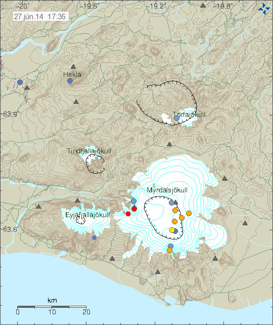
Earthquake in Hekla volcano. Deep earthquake in Katla volcano

On the 17-March-2014 at 19:59 UTC an earthquake took place in Hekla volcano. This earthquake had the magnitude of 1,0 and the depth of 9,1 km. I did record it on my geophone just barley, it is possible to watch for activity in Hekla volcano here. This earthquake does not mean that Hekla volcano is about to erupt, but it is interesting anyway. What it means remains unclear at the present time.

140319_1810
The earthquake in Hekla volcano. It is marked with an blue dot. Copyright of this image belongs to Icelandic Meteorological Office.

Katla volcano

Yesterday (18-March-2014) an deep earthquake (in the picture above, in the central caldera) took place in Katla volcano. The magnitude of this earthquake was 0,7 and this earthquake had the depth of 28,9 km. As was mentioned in comment yesterday. This earthquake in it self is no important from the looks of it. No special harmonic activity took place following this earthquake.

alf.svd.19.03.2014
All quiet. Just wind and ocean waves. The spike on the 19-March-2014 is due to earthquake in Goðabunga part of Katla volcano. Copyright of this image belongs to Icelandic Meteorological Office.

Donations: Please remember to support my work by donation. Thanks!

Advertisements:

I did try to go advertisement free (for the second time) and it failed again. Since I need the extra income from this website and from my writing work to make a proper living. I want to be advertisement free, as I did explain here (I have updated this post now). Going advertisement free requires donations that I am simply not getting and it is an fact one cannot be without money. Without it it’s just hunger and pain. As it is not far from what I am currently experiencing (I got €0,49 in my bank account at current time or 3,61 DKK). The thing however is that I am well advised in not having any money so I prepare a little in terms of buying food but currently I am at my limit. I am not sure what the rest of this month (March) is going to be for me. This site might one day be advertisement free, that is however not going to happen until I can afford it. When that might be I have no idea.

The job question:

Many people wonders why I don’t have a job and many people expect that I have a job and don’t ask for donations. I have asperger’s syndrome [Second link here]. I have problem with working a normal job. It’s not that I am not physically able, because I am. But I have problem with communications and dealing with work social things. I have issues with normal social stuff on every day. I can and I have worked for a short period of time, but such things always drain me mentally and make things difficult for me in the long run. It would also prevent me from monitoring earthquakes and volcanoes as I do now. I am also writing more stories and I have already published one, even if I have not yet sold many copies so far.

Blog post updated at 20:45 UTC. Time of the earthquake corrected.
Blog post updated at 21:55 UTC.

More magma in Hekla magma chamber then before 2000 eruption

According to news today on mbl.is there is now more magma in Hekla volcano then before the 2000 eruption. The news says that since the year 2006 there has been more magma in Hekla magma chamber then before the last eruption in the year 2000. This has not meant an eruption so far. Hekla volcano magma chamber have the depth of around 10 to 20 km. This means this inflation that is now taking place does not appear clearly on the surface, but changes are being measured by GPS system that Icelandic Meteorological Office has. This is also appearing on GPS instruments that geological department University of Iceland has. Even if inflation is now more in Hekla volcano then during the eruptions in the year 1991 and 2000 it does not mean that next eruption is going to be bigger. Since the size of the eruption depends on how much of the magma is mobile in the magma chamber. That amount remains unknown until eruption takes place and even then not all of the mobile magma might erupt.

It is also pointed out in the news that it is risky to go on top of Hekla volcano as is. At least while no eruption has taken place currently. Since the risk of eruption is in place and the time from magma starts to move and until eruption takes place is short. Often less then 1 hour. It is advised in this news that people should not go on top of Hekla volcano. The risk is that eruption starts and trap people on top of the volcano, with deadly consequences.

It is possible to read the Icelandic news here. Please use Google Translate with care. It’s not always correct.

Kvikusöfnun meiri í Heklu en árið 2000 (mbl.is)

Donation notice: Please remember to donate and support my work (I am having one of the bad and awful months now). Thanks!

Increasing conductivity in Skeiðará glacier river (Grímsfjall volcano)

Since 20-January-2014 there has been increase in conductivity in Skeiðará glacier river that comes from Vatnajökull glacier. The reason for this change is that water is leaking from Grímsfjall volcano. Water levels have also been increasing and dropping during this time since this started.

gigjukvisl.svd.14.03.2014.vedur.is
The conductivity in Skeiðará glacier river from 20-January-2014. Picture from Icelandic Meteorological Office Facebook page. Copyright of this image belongs to Icelandic Meteorological Office.

Conductivity is now measured at 416 µS/cm and according to Icelandic Meteorological Office that is an high value coming from Grímsfjall volcano. This water also goes trough several lakes and before it reaches the sensor at Gígjukvísl bride. So at the source of Skeiðará glacier river this value is probably even higher. No major earthquake activity and no harmonic tremor activity has taken place following this water leak from Grímsvötnum glacier lakes. But it appears that some glacier quakes might be taking place at the moment. Such activity can be seen here on IMO website. Currently the volume of water in Grímsvötn glacier lakes is small since the eruption that took place in Grímsfjall volcano in the year 2011. Coverage of that eruption can be found here. At current time nothing more is expected to happen.

Donation notice: Please remember to support my work with donation. Otherwise I am going to have really bad month of March-2014 food wise. Thanks for the support.

Deep earthquake in Hamarinn volcano

Today (25-February-2014) at 09:49 UTC an deep earthquake took place in Hamarinn volcano (is under Bárðarbunga volcano at GVP database as Loki-Fögrufjöll). This earthquake had the depth of 29,6 km and magnitude of 1,8. This means it was created by magma movement rather then tectonic forces.

140225_2030
The earthquake that had the depth of 29,6 km is located 12,5 km south of Hamarinn (64,417 -17,605). Copyright of this image belongs to Icelandic Meteorological Office.

Hamarinn volcano last erupted in July 2011 [coverage of that can be found here] in an minor eruption that lasted for few hours but resulted in glacier flood in the area. Since then activity has dropped, but over the recent months it has been picking up again slowly. So far it is just earthquakes at depth. Harminn volcano is highly active volcano, even if it is not constantly erupting at the moment. The reason is that it is almost centre above the hot spot fuels the eruption activity in this area.

Blog post updated at 21:28 UTC.