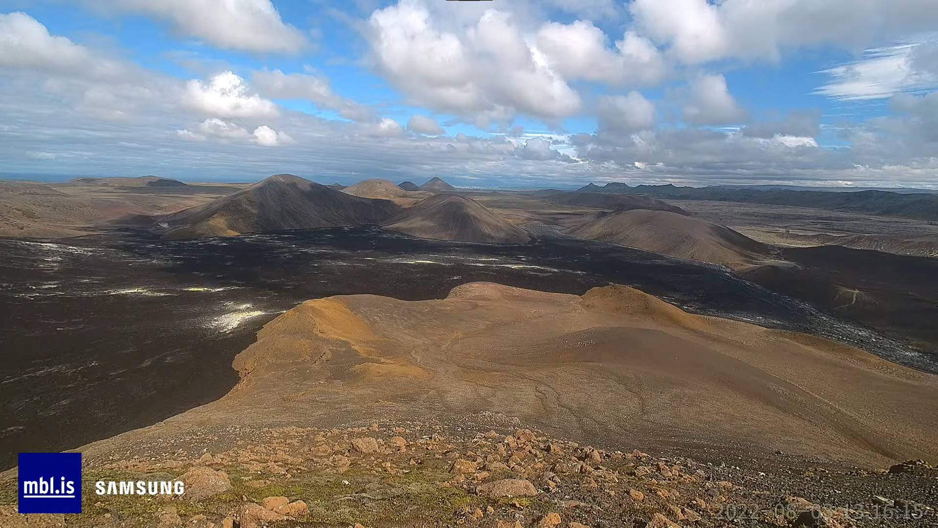
Today (03-August-2022) at around 13:30 UTC an eruption started in Fagradalsfjall mountain, just north of the eruption site that took place in March to September 2021. The fissure that is now erupting is growing both to south and north. That suggest that the power of the eruption is currently growing.
This is all the information I have at the moment. This eruption is clearly visible on the web cameras that mbl.is has on YouTube, along with web camera from Rúv.
I’ll post new information when I get them. I don’t know when that is going to be.
Donations
Please remember to support my work with donations. Thanks for the support. 🙂
Update 1
Based on this image from Morgunblaðið web camera. The eruption started at 13:16 UTC.
Image from Morgunblaðið web camera when the magma breaks the crust and starts the eruption. Copyright of this image belongs to Morgunblaðið/YouTube screenshot. – This image might be removed if requested.
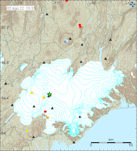
Today (2-August-2022) at 14:24 UTC an earthquake with magnitude of Mw3,7 took place in Grímsfjall volcano. At the writing of this article there doesn’t seem to be any indicator that an eruption is about to start, but that might change without warning.
Earthquake activity in Grímsfjall volcano. Copyright of this image belongs to Icelandic Met Office.
There were few other smaller earthquakes following and before the largest earthquake. This earthquake activity is slightly unusual since normally Grímsfjall volcano doesn’t have any earthquake activity unless an eruption is about to start. If this earthquake activity continues is impossible to know.
This is a short article because the situation changes constantly.
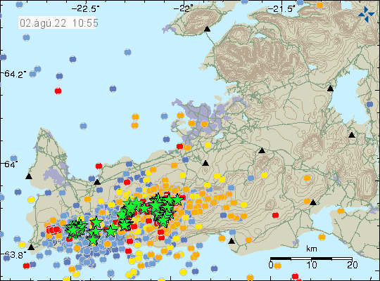
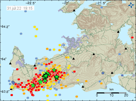
This was not a night where many people in Reykjavík got a good night sleep. A magnitude Mw5,0 earthquake took place at 02:27 UTC and was felt in Reykjavík, few seconds earlier a magnitude Mw4,7 earthquake took place. Earlier three earthquakes with magnitudes of Mw4,3 to Mw4,5 had taken place, this was just around midnight and was also felt in Reykjavík. Over 10 000 earthquakes have been recorded since Saturday when this all started. The earthquake activity during the night was at the western end of Kleifarvatn lake and was for that reason felt clearly in Reykjavík. Minor damage was reported with the earthquake around midnight. Other reports of damage have not been reported so far.
Heavy earthquake activity on Reykjanes peninsula. Copyright of this image belongs to Icelandic Met Office.
The strong earthquakes during the night where fault earthquakes, that happen because of the inflation that is now taking place north of Fagradalsfjall mountain. GPS data has also been showing a interesting patter. There is now a deflation taking place in Gónhóll and the crater, while that area also seems to be on the move north (?). The 24 GPS data can be viewed here and 8 hours GPS data can be viewed here.
This earthquake activity is going to continue until an eruption starts. When that happens is impossible to know. More stronger earthquakes can be expected in next few hours and days on Reykjanes peninsula.
Donations
Please remember to support my work. That stops me from being broke and I don’t need many donations to stop being broke. Thanks for the support. 🙂
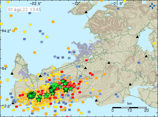
This is a short update on the earthquake swarm in Fagradalsfjall mountain and nearby area. This is written on 1-August-2022 at 13:47 UTC.
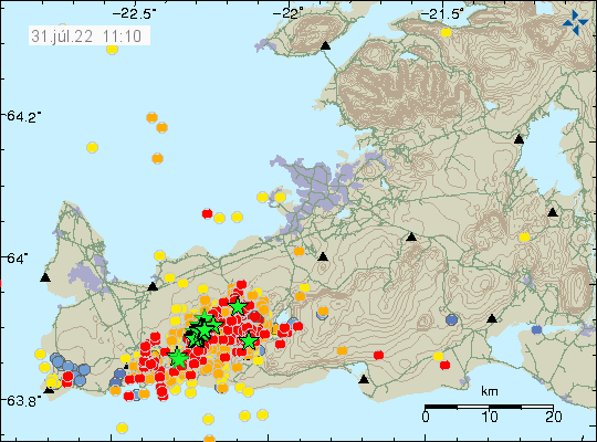
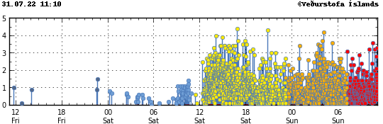
The situation on Reykjanes peninsula is always updating so information in this article can be in part or in whole get obsolete quickly. Largest earthquake during the night had a magnitude of Mw4,7. This might not be the largest earthquake today, since larger earthquakes are always a possibility.
Strong earthquake activity on Reykjanes peninsula. Copyright of this image belongs to Icelandic Met Office.Time trace of the earthquake activity in the last 48 hours. Copyright of this image belongs to Icelandic Met Office.
GPS data have started to show a large displacement over the last 48 hours. The 24 hour GPS displacement can be found here and 8 hour GPS displacement data can be found here (find Reykjanes peninsula). This shows that magma is pushing its way though the crust at fast speed, but has not yet broken up trough the crust. When that happens is impossible to know, but this might not be a long wait based on the speed the magma is going. Current depth of the magma is around 2 to 4 km.
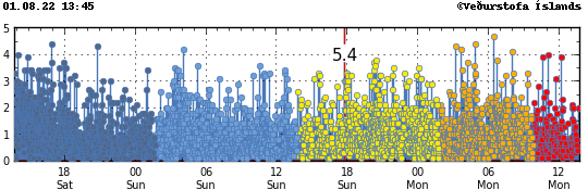
Today (31-July-2022) at 17:48 UTC an earthquake with magnitude of Mw5,4 took place 3,2 km east of Grindavík town. This earthquake was felt over a wide area of Iceland and all the way to Westfjörd in few towns that are there. Damage has been reported in Grindavík town, with cold water main breaking and damage to house items, damages to houses is unclear at the writing of this article. New news reports show that items in grocery stores have been thrown out of their shelf.
The earthquake activity on Reykjanes peninsula and close to Grindavík town. Copyright of this image belongs to Icelandic Met Office.
This earthquake is a fault earthquake and as such not directly connected to a magma movement in Fagradalsfjall mountain, however, the magma movement in Fagradalsfjall mountain is the engine that makes this earthquake possible in this location. There is a chance that two magnitude Mw5,4 earthquakes took place at the same time east of Grindavík town. This was mentioned in Rúv news about the earthquake, such earthquakes are a lot more complicated and harder to get correct magnitude for. More earthquakes like this can be expected in this area or closer to Reykjavík city at any time without warning.
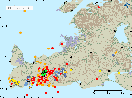
This is going to be a short update because the situation is constantly changing. This update is written at 12:07 UTC on 31-July-2022.
At the writing of this article at 11:32 UTC no eruption has started in Fagradalsfjall mountain or nearby area. Over 3000 earthquakes have been recorded in the last 24 hours in and around Fagradalsfjall mountain since the earthquake activity started yesterday (30-July-2022). There have not been any major changes in the crater in Fagradalsfjall mountain, it does seem to release more gas than normal. That is at least how it appears, if that is real or not I don’t know.
Heavy earthquake activity on Reykjanes peninsula. Copyright of this image belongs to Icelandic Met Office.The earthquake activity in the last 48 hours. Copyright of this image belongs to Icelandic Met Office.
I think this might be a stronger activity than last year, but if that is correct estimate is a wait and see. There has not been any major change in GPS location and that suggest that the area is as inflated as it possibly can be. It is impossible to know when the magma breaks up in the crust, but earthquake activity suggests that it has reached the depth of 2 km, meaning the magma has moved up a lot in the last 24 hours, since this earthquake activity started on the depth of 8 km yesterday.
Donations
Please remember to support my work with donations. Thanks for the support. 🙂
I was busy today so I only just got home and this article is going to be a short one.
Today around (09:00 UTC) a small earthquake swarm took place in Fagradalsfjall mountain. At around 12:00 UTC an stronger and more massive earthquake swarm started in Fagradalsfjall mountain. At the writing of this article more than 700 earthquakes have been recorded and that is possibly an underestimate. At the writing of this article, largest earthquake had a magnitude of Mw4,4 and more than eighteen earthquakes with magnitude above Mw3,0 had taken place. Many of them were felt in Reykjavík and other nearby towns.
A lot of earthquake activity in Reykjanes peninsula in Fagradalsfjall mountain. Copyright of this image belongs to Icelandic Met Office.The time overview of the earthquake activity in Reykjanes peninsula and Fagradalsfjalli mountain. Copyright of this image belongs to Icelandic Met Office.
It is difficult to know when a eruption is going to start. I find that the most likely outcome of this earthquake swarm. The magnitude of the harmonic tremor suggests that an eruption would be larger than last eruption in Fagradalsfjalli mountain. It is impossible to know if that is going to happen until an eruption starts. Currently the harmonic tremor was or is dropping. I do think it is going to increase again since that seems to be a pattern in this cases of magma intrusion until an eruption starts.
I’ll post more updates as this continues. Rúv and mbl.is have turned on their web cameras. They can be found on YouTube.
Donations
Please remember to support my work with donations. Thanks for the support. 🙂
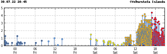
At 22:57 UTC on 29-July-2022 an earthquake with magnitude of Mw4,2 took place in Katla volcano. Few smaller earthquakes have happened following this earthquake. Magnitude of this earthquake might still change, since earthquakes in Katla volcano are the type of earthquake it takes time to get correct magnitude.
Earthquake activity in Katla volcano. Copyright of this image belongs to Icelandic Met Office.
I don’t know what is going on. This might just be normal summer earthquake activity and Katla volcano sometimes has this stronger earthquakes without an eruption happening. This is going to be a little wait and see on what happens next in Katla volcano.
Donations
Please remember to support my work with donations. Thanks for the support. 🙂
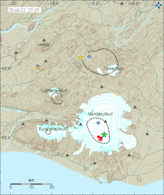
Today (24-July-2022) at 13:45 UTC and earthquake with magnitude of Mw4,9 took place in Bárðarbunga volcano. Before this earthquake happened, an slightly smaller earthquake took place with magnitude of Mw4,4.
Green stars in Bárðarbunga volcano, that is in Vatnajökull glacier. Copyright of this image belongs to Icelandic Met Office.
According to news reports, last earthquake of this magnitude took place in January 2020. This earthquake activity is because of inflow of magma and inflation of Bárðarbunga volcano. This is not going to result in a eruption, this however shows that Bárðarbunga volcano is preparing for an eruption in next few decades or sooner.
Donations
Please remember to support my work with donations. Currently I am completely broke and that’s not good with slightly more than one week left on the month of July. Thanks for the support. 🙂
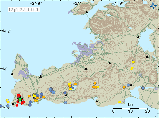
This morning (12-July-2022) an earthquake swarm took place in Reykjanes volcano. This earthquake swarm has at the writing of this article around 30 earthquakes. Two largest earthquakes had a magnitude of Mw3,3 and Mw3,4. The second earthquake was felt in towns on Reykjanes peninsula.
Earthquake swarm on the Reykjanes peninsula in the Reykjanes volcano. Copyright of this image belongs to Icelandic Met Office.
It has been rather quiet on the Reykjanes peninsula in last few months. There is always minor earthquake activity happening because of inflation of magma in this area. There has been lack of large earthquakes in recent months. I don’t know why that is. GPS data show that there has not been any notable inflation or deflation in Reykjanes volcano for the last few weeks. That translates into lack of earthquakes. If this earthquake swarm means that is changing is something to watch out for. Small earthquake swarm can mean change, what it means here is unclear. It is known that not every eruption starts with a big earthquake swarm in a volcano.
Donations
Please remember to support my work. Thanks for the support. 🙂
Cookie acceptance
We use cookies on our website to give you the most relevant experience by remembering your preferences and repeat visits. By clicking “Accept”, you consent to the use of ALL the cookies.
This website uses cookies to improve your experience while you navigate through the website. Out of these cookies, the cookies that are categorized as necessary are stored on your browser as they are essential for the working of basic functionalities of the website. We also use third-party cookies that help us analyze and understand how you use this website. These cookies will be stored in your browser only with your consent. You also have the option to opt-out of these cookies. But opting out of some of these cookies may have an effect on your browsing experience.
Necessary cookies are absolutely essential for the website to function properly. This category only includes cookies that ensures basic functionalities and security features of the website. These cookies do not store any personal information.
Functional cookies help to perform certain functionalities like sharing the content of the website on social media platforms, collect feedbacks, and other third-party features.
Performance cookies are used to understand and analyze the key performance indexes of the website which helps in delivering a better user experience for the visitors.
Analytical cookies are used to understand how visitors interact with the website. These cookies help provide information on metrics the number of visitors, bounce rate, traffic source, etc.
Advertisement cookies are used to provide visitors with relevant ads and marketing campaigns. These cookies track visitors across websites and collect information to provide customized ads.