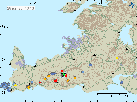
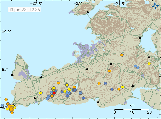
New hot springs detected at Road 1 in Hveradalabrekka in Hengill volcano

The Icelandic Road administration did send out this news report today that new hot springs have been detected at Hveradalabrekka on Road 1 in Hengill volcano. This is an area that sees some heavy traffic. I can’t post pictures here because of copyright, but they can viewed in the news article below.

According to the Icelandic Road administration it seems that the area in question has been getting warmer for some time. According to them the current temperature around 86 degrees celsius. This is the area on a map from ja.is website.

The main road one as it is south of Reykjafell mountain in Hengill volcano. Also on this map is Þrenslahnjúkur and Hveradalir are marked in on the map.
The main road 1 on Hengill volcano. Close to the area that is now warming up. Screenshot of map from ja.is.

Next is to check why this is happening and if there is any risk the Road 1 in this area and if anything can be done if that’s the case. I am unclear on what is going on, since this area (I don’t think this one, but nearby) is known for hot spring activity. There has been some earthquake activity at this location in recent months and that is possibly connected to this new hot spring activity. On 9th of May this area had a Mw1,1 earthquake at the depth of 4 km. Over a time period of 130 days, the number of earthquakes in this area is not unusual for Hengill volcano or Reykjanes peninsula in general. This area of Road 1 might continue to get warmer over the next few months.

Vegagerðin news in Icelandic

Jarðhitavirkni undir Hringvegi (vegagerdin.is) – has pictures of the area.

Update

Rúv has published a news about this and has a video of the area where this new hot spring activity is happening. This is new because vegetation is in this area and is now dying off.

Allt að 100 gráðu hiti mælist við veginn (Rúv.is, Icelandic)

Update 2

Icelandic Road Administration web camera shows the new hot spring area. The web camera can be viewed here.

Article updated 12. May 2023 at 20:41 – Reykjavík time (+0 GMT)
Article updated 14. May 2023 at 13:01 – Reykjavík time (+0 GMT)

Earthquake swarm in Þórðarhyrna volcano

Today (11. May 2023) there was a earthquake swarm in Þórðarhyrna volcano. This are small earthquakes, but their location and depth suggest that this is a dyke intrusion taking place at this location.

Earthquake swarm in south-west part of Þórðarhyrna volcano. This volcano is located in Vatnajökull glacier, just few km south of Grímsfjall volcano, is part of the Grímsfjall volcano fissure swarm. Time on image 11. May. 23 13:10.
Earthquake activity in Þórðarhyrna volcano. Copyright of this image belongs to Icelandic Met Office.

Þórðarhyrna volcano is part of Grímsfjall volcano fissure swarm, that connects to Laki eruption fissures. Last eruption in Þórðarhyrna volcano was in the year 1902 to 1904 and had the VEI=4 according to Global Volcanism Program report that can be read here.

Earthquake swarm in Reykjanes volcano (out in the ocean)

During the night of 4. May 2023 an earthquake swarm took place in the Reykjanes volcano out in the ocean. This was not a large earthquake swarm. Largest earthquake recorded had a magnitude of Mw3,4. Other earthquakes where smaller in magnitude.

Green star and a cluster of earthquakes on down and west part of this image. Showing the Reykjanes peninsula. Few other earthquakes are dotted on the map in other volcanoes on the Reykjanes peninsula.
Earthquake swarm in Reykjanes volcano. Copyright of this image belongs to Icelandic Met Office.

This earthquake activity suggests an dyke intrusion in this area. This is part of Reykjanes volcano, but that volcano is in part out in the ocean. The Reykjanes volcano has been having regular dyke intrusion in recent years without it resulting in an eruption. That is most likely what is going to happen now.

Strong earthquake swarm in Katla volcano

This morning there was a strong earthquake swarm in Katla volcano. At the writing of this article the largest earthquake had a magnitude of Mw4,8 and the second largest earthquake had a magnitude of Mw4,7, the third largest earthquake had a magnitude of Mw4,5. This earthquakes where felt in nearby farms and towns close to Katla volcano. Currently, a lot of smaller earthquakes have happened in Katla volcano.

Red dots and green stars in Katla volcano caldera showing the main earthquake activity.
Earthquake activity in Katla volcano. Copyright of this image belongs to Icelandic Met Office.

There are no changes in harmonic tremor levels at the writing of this article. That makes an eruption unlikely to happen now. That might change later without warning. The air aviation code has been moved to yellow and can be viewed here.

I’ll write a new article if something more happens.

Earthquake swarm north of Grindavík town, next to Blue Lagoon

This morning (25. April 2023) an earthquake swarm started north of Grindavík town, next to the Blue Lagoon. This earthquake swarm is ongoing at the writing of this article. If this is going to result in a eruption is impossible to know. The magma has reached the depth of 2 km and that is not good news if this continues to intensify. Large earthquakes do not need to happen before an eruption starts under the correct conditions in the curst and there has been a lot of dyke activity in Reykjanes volcano in last 3 years. Without that activity resulting in a eruption.

Red dots north of Grindavík town and next to the Blue lagoon on the map (the lagoon doesn't appear on the map). Time on map 25. Apr. 14:00.
Earthquake activity north of Grindavík town. Copyright of this image belongs to Icelandic Met Office.

Eruption at this location would be bad, because of the tourist infrastructure next to this location that is the Blue Lagoon. Only thing that can be done now is to monitor the situation and see if it changes from what is currently happening.

It is possible to view the earthquake swarm in high resolution on Skjálfta-Lísa and other private websites that have similar maps.

Earthquake swarm in Grímsfjall volcano

Today (23. April 2023) at 15:!5 UTC an earthquake swarm took place in Grímsfjall volcano. Largest earthquake in this swarm had a magnitude of Mw3,3. Few other smaller earthquakes also took place.

Green star and red dots under it in Grímsfjall volcano. Also in this image is the earlier earthquake in Bárðarbunga volcano, shown with a green star.
Earthquake activity in Grímsfjall volcano. Copyright of this image belongs to Icelandic Met Office.

There are no signs that Grímsfjall volcano is about erupt following this earthquake swarm. That might change without warning, but seems unlikely to happen at the moment. More earthquakes might happen in next few hours.

Small earthquake swarm in south part of Brennisteinsfjöll volcano

Today (13. April 2023) there has been a small earthquake swarm in south part of Brennisteinfjöll volcano. This location had an earthquake swarm few weeks ago at this same location. It also was small in magnitude. Depth of this earthquake swarm has now decreased from 7 km to around 3 km. At least that is what it seems, based on the current earthquake data.

Red dots in south of Brennisteinsfjöll volcano showing the minor earthquake activity now taking place in this volcano. Nearby volcano also have minor earthquake activity, shown in orange to red dots.
Earthquake activity in Brennisteinsfjöll volcano. Copyright of this image belongs to Icelandic Met Office.

This earthquake activity shows a sign of magma movement. It is my opinion that the magma is now pushing it self trough the crust at this location. That can take a while, up to several weeks before an eruption starts. I did see something similar happen before the Bárðarbunga volcano eruption in 2014. That process took good three months before the eruption and was marked by small earthquake swarm like this one. How long this is going to take is impossible to know, because what type of crust is at this location is not well understood (outside of types of rock it is made out of at the first top layers). This is in my view an earthquake activity that needs to be monitored, because of possible eruption risk at this location. This is directly north of a small lake south of the earthquake swarm. If an eruption happens and the lava flows into the lake, that might create a lot of problems.

This earthquake swarm can be viewed here in more details. The website is Skjálfta-Lísa and is only in Icelandic.

Earthquake swarm in Fremrinámar volcano

An earthquake swarm in a volcano called Fremrinámar today (30. March 2023). This is the first time I’ve seen an earthquake swarm in this volcano. All earthquakes where small in magnitude and the magnitude range was from Mw0,1 to Mw1,0. Depth was 5,8 km to 9,1 km.

Fremrinámar volcano is located on this image south of Krafla volcano, located close to Mývatn lake in eastern north Iceland. Few orange dots are on the map showing the earthquake activity.
Fremrinámar is located south of Krafla volcano. Copyright of this image belongs to Icelandic Met Office.

This is the first time I’ve seen an earthquake activity in this volcano. I’ve been monitoring earthquake activity for close to 30 years at the writing of this article. Last eruption in Fremrinámar volcano took place around 3200 years ago (1200 BCE according to Global Volcanism Program). There is a second (and I assume newly discovered) volcano north of Fremrinámar volcano and south of Krafla volcano called Heiðarsporðar. That volcano last erupted around 2200 years ago. This earthquake activity doesn’t seems to be in that volcano, but this map on Icelandic Met Office website is not fully up to date it seems. Based on the volcano website Catalogue of Icelandic Volcanoes. This earthquake activity is only mentioned here now, because I’ve never seen an earthquake swarm in this volcano before.

Earthquake activity in Bárðarbunga volcano

Today (19. March 2023) at 14:59 UTC an earthquake with magnitude of Mw3,1 took place in Bárðarbunga volcano. This is normal earthquake activity and shows the inflation that is happening in Bárðarbunga volcano is ongoing after the end of the eruption in 2015.

Vatnajökull glacier, in north-west of it, close to the edge of the glacier there's a green star and a red dot were the Bárðarbunga volcano is and it shows the earthquake activity that happened today.
Earthquake activity in Bárðarbunga volcano. Copyright of this image belongs to Icelandic Met Office.

This type of earthquake activity happens once to twice a month with a earthquake close to magnitude five happening every three to four months. This earthquake activity is getting lower with time, it is likely that it is going to take few more years until it completely stops.

Early signs of next eruption phase in Fagradalsfjall volcano

Since end of February 2023 there have been slowly growing signs in form of a small earthquake activity in Fagradalsfjall volcano and nearby area. It is impossible to know when next eruption starts in Fagradalsfjall volcano, but last time the quiet time was around 10 months. If it is going to be shorter or longer now is impossible to know.

Red dots and orange dots, not many of them in Fagradalsfjall volcano, in Krýsuvík-Trölladyngja volcano east of Fagradalsfjall and orange and blue dots west of Fagradalsfjall volcano in the volcano Reykjanes.
Earthquake activity in Fagradalsfjall volcano. Copyright of this image belongs to Icelandic Met Office.

Currently the earthquake activity is minor, but that can change quickly and without much warning. At the writing of this article, its been 6 months and 24 days since the eruption in Meradalir valley ended. I don’t know if this is going to happen the same was as it did before last eruption. Since there’s a lot of magma at depth of 5 to 10 km now and that changes how everything functions and behaves in the crust.