Updated information on Askja volcano landslide

This is a short update on Askja volcano landslide.

Travel ban is still in effect to Askja volcano. Parts of it are going to be lifted later today or tomorrow, but access to Askja lake is going to remain forbidden at least until Friday, after estimates on risk of new landslides have been performed by Icelandic Meteorological Office and Civil Protection in Iceland (Almannavarnir). Risk of new landslides taking place in this area remains and might remain for many months to come. It is now estimated that 50 to 60 million cubic meters of material did collapse down into Askja lake, but with only part of the material ending up into the lake it self. New estimates on the flood waves that where created now put them around 50 meters high, there was also not one wave that took place, but it is now estimated that four waves took place once the landslide hit the water.

Hiking paths to Askja volcano and Víti have been closed due landslide risk in the area around Askja lake. Please respect this closure since this area is now highly unstable and more landslides might fall without warning.

Update 1: The landslide (or rock slide as IMO calls this) is now estimated to be around 1 km wide. The tsunami waves that followed this landslide in Askja lake are now estimated to have been around 73 meters high (around Hallgrímskirkja church high). The area remains closed and is now regarded as highly unstable. Risk of new landslides in this area remains high at current time. The amount of soil that did just go into Askja lake is estimated to have been around 24 million cubic meters, with the total amount much higher (this is unconfirmed number).

I will post more information as more is known what happened.

Icelandic news of this

„Bráðabani“ að fara niður að vatn­inu (mbl.is)
Víga­leg­ur mökk­ur steig til him­ins (mbl.is, pictures)
Lukka að þetta gerist um miðnætti (Rúv.is)
Svona lítur Askja út í dag – Myndband (Rúv.is, video of Askja today)
Askja – fyrir og eftir berghlaupið (Rúv.is, this are before and after images of Askja)
Berghlaupið í Öskju eitt það stærsta (Rúv.is, new video of Askja area)

Donations: Please remember to donate to support my work (and keep me away from starving). I will move back to Iceland in December (see here). Thanks for the support.

Article updated at 13:55 UTC.
Article updated at 16:01 UTC.
Article updated at 22:16 UTC.
Article updated at 22:18 UTC.

All traffic to Askja volcano forbidden due to a large landside yesterday (22-July-2014)

According to Icelandic Meteorological Office, a large landslide fell yesterday (22-July-2014) around midnight in Askja volcano, the landslide did go into Askja lake creating a flood wave that was 100 to 200 meters high. It did reach the other end of the crater lake and did flow over its edge, some water did go into Víti crater. This landslide took place in south part of the Askja lake crater (best information I have at the moment). Harmonic tremor was detected following this events, it was recorded for 20 minutes according to news reports (no image since Askja harmonic tremor plot image is missing in IMO website).

A cloud was seen following this landslide, it is not clear if it was steam or just loose dirt material moving up into the air. Early estimates into this landslide are that around 24 million cubic meters of material did come down with this landslide, part of it ending in Askja lake and raising the water levels in Askja lake some two meters (early estimates). Until this matter has been checked by scientist and Almannavarnir in Iceland, all traffic to Askja volcano is forbidden. There is also a risk of more landslides taking place in Askja volcano, since the soil where the landslide took place might not have settled yet. It is highly dangerous to go there under the current conditions and I urge anyone not to go there due to how dangerous this area now is.

Update 1: Image of the landslide can be found here.

I am going to post more information about this once I have more details on this event.

Icelandic news on this

Öll umferð bönnuð um Öskju eftir gríðarlega stóra skriðu (DV.is)
Umferð um Öskju bönnuð eftir stóra skriðu (Rúv.is)
Stór skriða féll í Öskju­vatn (Mbl.is)

Donations: Please remember to donate. While I am going to move back to Iceland in December. I still have to make it until then (somehow). Thanks for the support.

Article updated at 00:34 UTC on 23-July-2014.

New earthquake swarm in Herðubreið

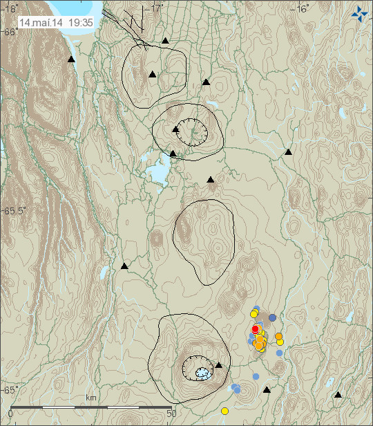
Yesterday (14-May-2014) an earthquake swarm started in Herðubreið, after an earthquake swarm in Heruðbreiðartögl dropped in activity. Both earthquake swarms are currently active. The earthquake activity however drops between as the swarm activity picks up.

140514_1935_myvatn
The earthquake swarm in Herðubreið and Herðubreiðartögl. Copyright of this image belongs to Icelandic Meteorological Office.

Most of this earthquakes had the magnitude smaller then magnitude 2,0. There was one magnitude 2,4 earthquake in this swarm. Over 100 earthquakes where recorded during this swarm. It remains unclear what is creating this earthquake swarm. It might just be tectonic stresses in Herðubreið and nearby area, or this might be magma injection. So far there is nothing suggesting that an eruption is going to take place at this location.

Donations: Please remember to donate. I am now really, really broke and its just the middle of the month. Yes, I do hate being broke, but I don’t exactly have many options open to me at the moment when it comes to money. Thanks for the support.

Update on Herðubreiðartögl earthquake swarm 12-May-2014

This is the last update on the Herðubreiðartögl earthquake swarm for now.

During the weekend the earthquake activity in Herðubreiðartögl has been dropping in both magnitude and number of earthquakes taking place. No earthquake with magnitude 2,0 or stronger took place during the weekend.

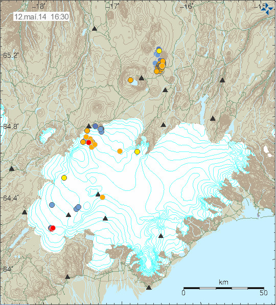
140512_1630
The earthquake activity in Herðubreiðartögl. Also in this picture, earthquake activity in Bárðarbunga volcano. Copyright of this image belongs to Icelandic Meteorological Office.

Earthquake activity has not stopped at Herðubreiðartögl, it might increase again. For the moment it has slowed down and is now at the levels it is not necessary for me to post regular updates on what is taking place. If any major change happens in Herðubreiðartögl I am going to post information about it.

Donation notice: Please remember to support my work here with a donation. Thanks for the support.

Update on earthquake swarm in Herðubreiðartögl on 9-May-2014

This is a short update for the earthquake swarm in Herðubreiðartögl on the 9-May-2014.

For the past 24 hours there has been drop in activity and no earthquake has been over magnitude 2,0. Activity continues but a lot lower levels then before. It does not look like it is over at this point, but the end of this soon to be seven day earthquake swarm in this area.

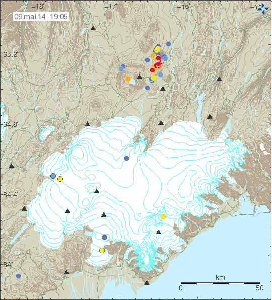
140509_1905
The earthquake swarm in Herðubreiðartögl as it was today. It can be seen that earthquake activity was at lot lower levels today then yesterday (08-May-2014) or the days before that. Copyright of this image belongs to Icelandic Meteorological Office.

140509_1905_tracer
This can also be seen in the tracer on Icelandic Meteorological Office website. Copyright of this image belongs to Icelandic Meteorological Office.

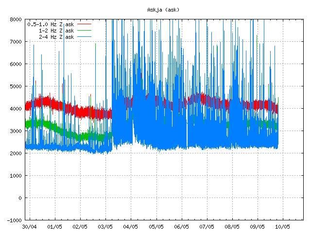
ask.svd.09.05.2014.at.19.35.utc
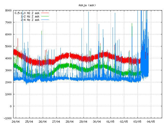
This drop in activity can also be seen in drop in the harmonic tremor plots in Askja. Fewer earthquakes means less earthquake related noise on the harmonic tremor plot (2-4Hz blue line). Not all of the activity that appears here is from Herðubreiðartögl, some of it is from SISZ and Reykjanes ridge activity. Copyright of this image belongs to Icelandic Meteorological Office.

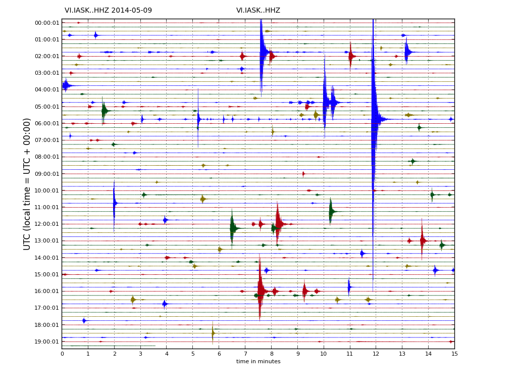
IASK.svd.09.05.2014.19.23.utc
The drumplot from Icelandic Meteorological Office also show this drop in activity. Some of the activity that appears is from Reykjanes Ridge. Copyright of this image belongs to Icelandic Meteorological Office.

None of this earthquake activity is strong enough to appear on my geophones. Since earthquakes at Herðubreiðartögl need to be at least magnitude 3,0 or larger to appear clearly on my geophones. My webicorders website can be found here, it shows all earthquakes that are taking place in Iceland and are large enough to appear on it. Its mostly earthquakes larger then magnitude 3,0 that are currently taking place (when this written).

Donation notice: Please remember to donate to support my work. Otherwise I am going to be broke this month and that is not a good thing. Thanks for the support.

Updated at 20:11 UTC.

Herðubreiðartögl earthquake swarm update 6-May-2014

This is an update on the earthquake swarm in Herðubreiðartögl on 6-May-2014. This information might go outdated quickly if the activity in this earthquake swarm changes suddenly.

For the past 24 hours the earthquake activity in Herðubreiðartögl has been dropping. This means fewer earthquakes overall, the magnitude of earthquakes taking place has also been getting lower, with strongest earthquakes just in the magnitude 2,5 to 2,9 range. In the past 24 hours no magnitude 3,0 or larger earthquake has taken place.

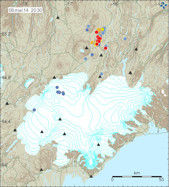
140506_2030
The earthquake activity in Herðubreiðartögl on 6-May-2014. Copyright of this image belongs to Icelandic Meteorological Office.

140506_2030_tracer
The earthquake tracer at Icelandic Meteorological Office website clearly shows the drop in activity. Copyright of this image belongs to Icelandic Meteorological Office.

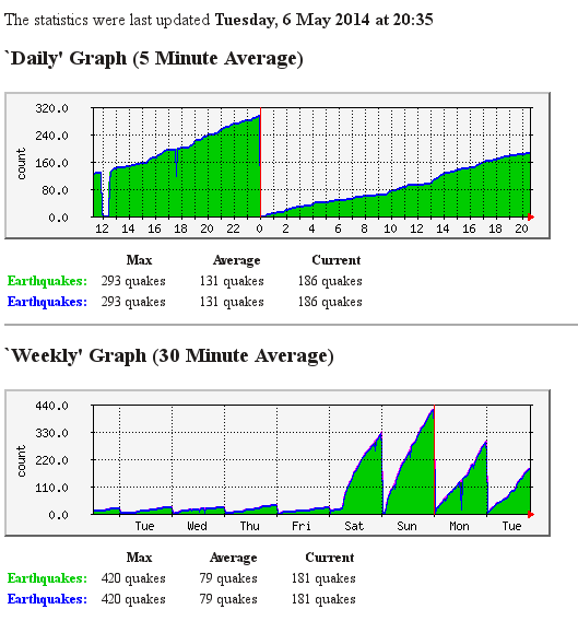
askja.counter.6-may-2014
My earthquake counter clearly shows this drop in earthquake activity. It is for all of Iceland, but majority of earthquakes over the past days are from Herðubreiðartögl. This image is released under Creative Commons Licence. Please see CC Licence page for more details.

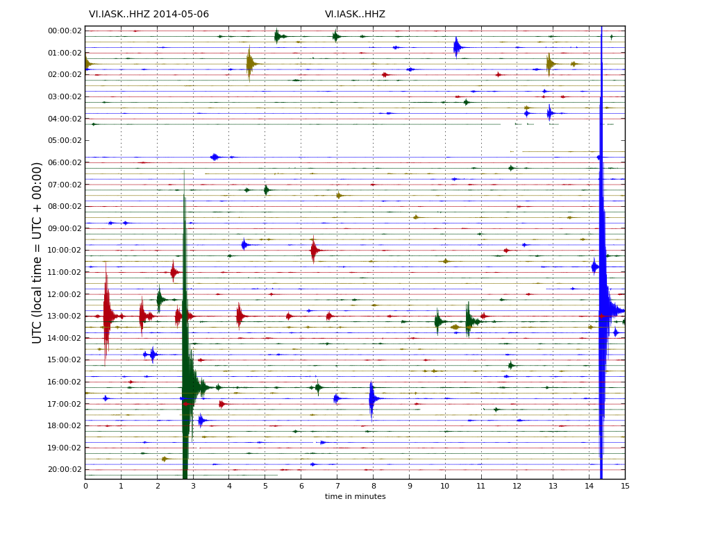
IASK.svd.06.05.2014.20.29.utc
I did discover today that Icelandic Meteorological Office has updated its drumplot website. So its now possible to see the earthquakes directly. The drumplot here above is from Askja SIL station, it clearly shows the earthquake activity in Herðubreiðartögl. The website with the drumplots can be found here (I have just found this website in Icelandic, there does not appear to be English version available). Copyright of this image belongs to Icelandic Meteorological Office.

It remains difficult to know for sure what is the source of this earthquake swarm. There is a slight chance it might be due to magma injection at depth, but that remains unproven as is. My geophone stations (I only got two running now) are going to show the largest earthquakes and they are going appear clearly. It can be viewed here.

Donations: Please remember to support my work. Otherwise I am going to have a rather poor month of May. Thanks for the support!

Article updated at 21:22 UTC on 6-May-2014.
Article updated at 21:37 UTC on 6-May-2014.

Update on ongoing earthquake swarm in Herðubreiðartögl

The earthquake swarm that started yesterday (03-May-2014) in Herðubreiðartöl continues. Information about this earthquake swarm changes quickly so this article about it is going to get obsoleted quickly. The largest earthquake in past 24 hours had the magnitude 3,9. Since around midnight over 370 earthquakes have been recorded. This means the earthquake swarm is more powerful in terms of earthquakes today than it was at the same time yesterday.

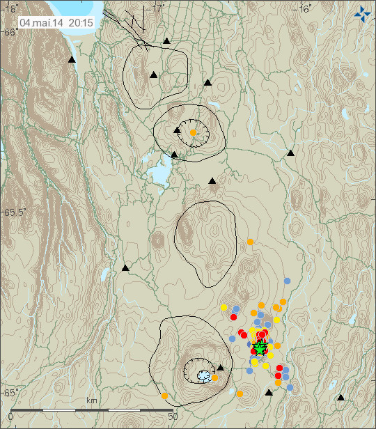
140504_2015
The earthquake swarm in Herðubreiðdartögl today. Copyright of this image belongs to Icelandic Meteorological Office.

140504_2015_tracer
The evolution of the earthquake swarm in Herðubreiðartögl today. As be seen here this earthquake swarm is heavy in number of earthquakes being detected. Copyright of this image belongs to Icelandic Meteorological Office.

ask.svd.04.05.2014.20.25.utc
The earthquake swarm in Herðubreiðartöl at Askja SIL station. As can be seen here this earthquake swarm is close to continuous. There is some minor drop in activity few hours ago before the earthquake activity picks up again. Copyright of this image belongs to Icelandic Meteorological Office.

mko.svd.04.05.2014.19.26.utc
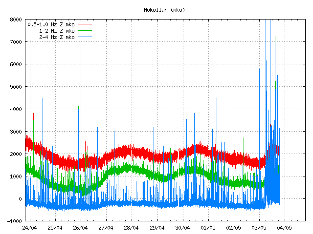
The earthquake swarm seen on the SIL station at Mókollar. It is close to what is seen on Askja SIL stations and other SIL stations around this area. Copyright of this image belongs to Icelandic Meteorological Office.

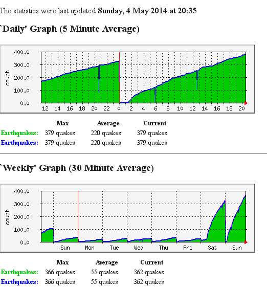
askja.counter.4-may-2014
My earthquake counter today showing all the activity. This gives me good comparison to how many earthquakes where recorded yesterday. This image is released under Creative Commons Licence. See CC Licence page for more details.

I am expecting more earthquake activity in Herðubreiðartögl next hours and even days. Since currently there are no signs of this earthquake swarm slowing down. The largest earthquakes (above magnitude 3,0) appear clearly on my geophone network website.

Ongoing earthquake swarm north of Herðubreiðartögl

Today (03-May-2014) around midnight (00:02 UTC) a earthquake swarm started north of Herðubreiðartöglum (Global Volcanism Program link on Askja volcano can be found here), this area is an small mountain ridge that has built up with regular eruptions over some period of time. The largest earthquake in this swarm took place this morning at 05:49 UTC and had the magnitude of 3,5 with the depth of 7,6 km. After this earthquake took place the swarm increased with many minor earthquakes. So far over 265 earthquakes have been recorded today, this number gets obsoleted quickly since new earthquakes happens ever 1 to 3 minute when I am writing this text.

Tremor plot on nearby SIL stations show that a lot more earthquake activity is taking place than appears on IMO earthquake website. Reason for this is simple, the earthquakes cannot be located since they are only detected at one or two SIL stations, a minimal of three or four SIL station are required for location of each earthquake. The tremor plot in the area also show that no magma is erupting, but that does exclude the possibly that magma injection is responsible for this earthquake swarm. It has not reached the surface and currently there is no eruption taking place at this location. If an eruption takes place in this location, it is going to be Hawaiian eruption with large lava flows.

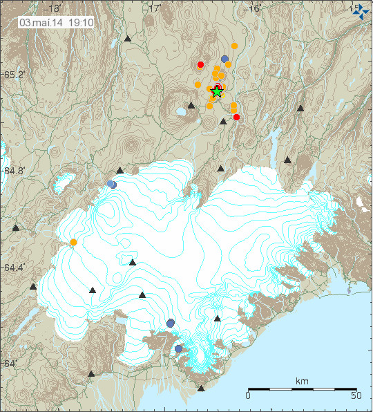
140503_1910
The earthquake swarm north of Herðubreiðartögl as they appear on Icelandic Meteorological Office maps. Copyright of this image belongs to Icelandic Meteorological Office.

140503_1910_tracer
The earthquake rate during this earthquake swarm. Copyright of this image belongs to Icelandic Meteorological Office.

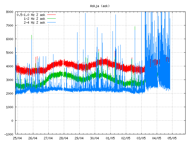
ask.svd.03.05.2014.19.37.utc
The SIL station in Askja volcano. As can be seen the earthquake swarm is dense and highly active. Copyright of this image belongs to Icelandic Meteorological Office.

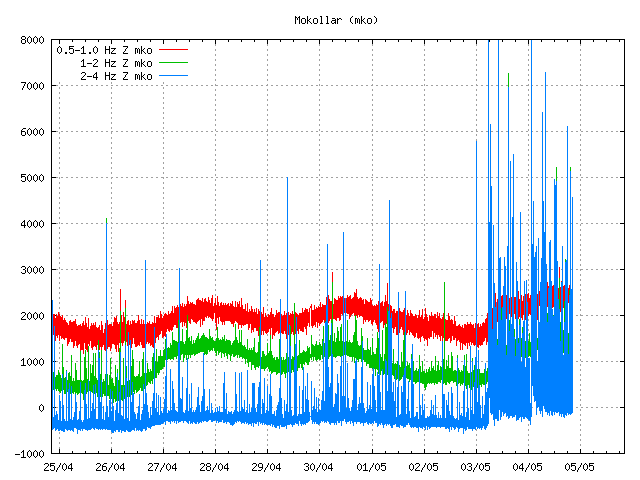
mko.svd.03.05.2014.19.38.utc
The SIL station south of Herðubreiðartögl, this SIL station is called Mókollar and the earthquake swarm appears clearly on it. Copyright of this image belongs to Icelandic Meteorological Office.

Earthquake swarms are common in this area and have been for a long time. Most of that earthquake activity has been contributed to normal tectonic activity in this region (plate tectonic movements). This area also has erupted in the past (last 12,000 years). I don’t think there have been any eruptions in this area in the past 1000 years, at least there are no such signs on the surface (crates, lavas). It is difficult to know what happens in this area for the next few hours to days, all that can be done is to continue monitor the activity that is now taking place. The largest earthquakes appears clearly on my Böðvarshólar geophone (link here), even if the distance is up to 200 km.

Donation note: Please remember to donate. Otherwise I am going to have a rather bad month of May in terms of being broke. Thanks for the support.

Earthquake activity in Hekla, Askja volcanoes and TFZ

Before I start. I want to remind people that donations are import to me. Since they help me keeping this blog and my earthquake web page up and running.

Hekla volcano earthquake activity

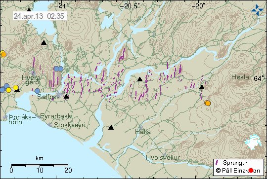
A minor earthquake activity took place in Hekla volcano yesterday. None of the earthquake was larger then ML1.2. The depth of this earthquake activity was around 8.4 km. This earthquake activity took place outside the main volcano. But was in the connected fissure swarms that extends from Hekla volcano.

130424_0235
Earthquake activity in Hekla volcano system. The earthquakes are the orange dots just south-west of Hekla volcano. Copyright of this image belongs to Icelandic Meteorological Office.

Earthquakes have been taking place in this area for few years now. I do not know what they mean. This might just be a earthquake activity and nothing else. Uncertainty level has been canceled for few weeks now due to lack of any more activity in the main Hekla volcano.

Askja volcano

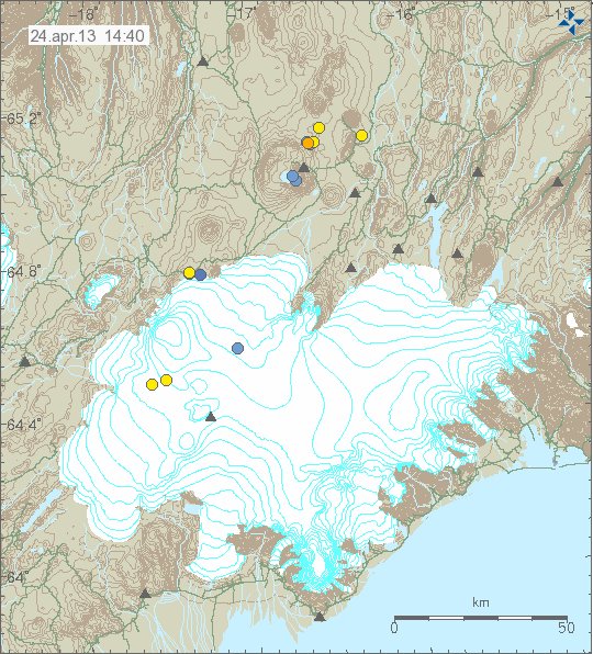
There has been minor earthquake activity in Askja volcano this past weeks. All of the earthquakes have been smaller then magnitude 1.5. Depth of this earthquakes is around 18 to 22 km. Suggesting that current earthquake activity has its source in magma movements rather then tectonic earthquakes.

130424_1440
Earthquakes in Askja volcano. Askja volcano is the volcano north-east of Vatnajökull glacier. Copyright of this image belongs to Icelandic Meteorological Office.

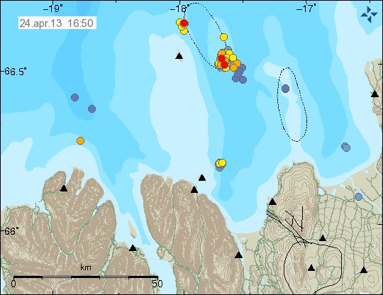
Tjörnes Fracture Zone

Activity in Tjörnes Fracture Zone has slowed down since 2. April when a large earthquake swarm started in it. But earthquake activity remains as is. Even if the earthquakes are smaller and fewer. This means the earthquake activity has been continuous for the past three weeks.

130424_1650
Earthquake activity in Tjörnes Fracture Zone. It remains in two areas as of now. New activity has also been taking place. Copyright of this image belongs to Icelandic Meteorological Office.

It is difficult to know for sure what happens next in TFZ. But tension in it remains as before and so does the risk for larger earthquake in this area. For the moment however, it remains rather quiet. When that might change is impossible to know for sure.

Blog post updated at 18:16 UTC on 24.04.2013.

Deep earthquakes in Askja and Kverkfjöll volcanoes

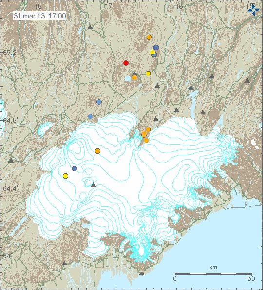
This is a update for both Askja and Kverkfjöll volcanoes. Since they both had deep earthquakes today. None of this earthquakes where larger then magnitude 1.0. There depth was around 22 to 24 km inside the volcanoes them self.

130331_1700
Earthquakes in Kverkfjöll and Askja volcanoes. There depth was around 22 to 25 km. Copyright of this image belongs to Icelandic Meteorological Office.

GVP Kverkfjöll volcano profile. GVP Askja volcano profile.

It is impossible to know for sure what this means in terms of future activity. But this are both active volcanoes and should be treated as such.