This is a short update on the eruption in Fagradalsfjall mountain in Krýsuvík-Trölladyngja volcano system.
There are no major changes reported during the last few days. But there have been minor changes in last few days. Here the latest changes that have been reported.
The oldest craters have stopped erupting. One of the crater has changed into a lava lake for now while the other is possible also a lava lake even if it is not visible. A lot of gas (smoke) comes from the more south crater in the crater row 1.
There are three to four craters that continue to erupt. There seems to have been a tiny increase in the eruption today (26-April-2021). This can be explained by how few craters are currently erupting.
No new craters have opened up in last few days. This is correct at the writing of this article.
Harmonic tremor seems to be decreasing. It is unclear why that is since the eruption is currently ongoing.
There are no other reports about the eruption. I am not sure when next update is going to happen but it is going to be soon as possible if anything changes in the eruption.
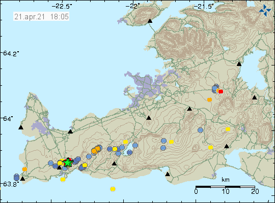
Yesterday (24-April-2021) an earthquake swarm took place in Krýsuvík volcano close to Kleifarvatn lake. The largest earthquake had a magnitude of Mw3,1 and the second largest earthquake had a magnitude of Mw3,0. Both earthquakes where felt in Reykjavík area and other nearby areas. This activity is closer to Reykjavík then earlier earthquake swarms.
The earthquake swarm close to Kleifarvatn lake. Copyright of this image belongs to Icelandic Met Office.
This earthquake activity is not connected to the eruption in Fagradalsfjall mountain. That however doesn’t rule out that magma might be the reason why this earthquake activity is happening. Currently the earthquake activity is too low for this to be a start of a second eruption. It is impossible to know if this is going to develop into anything more serious at the writing of this article. There needs to be a lot more earthquake activity in this location before an eruption starts, even if an eruption might not start with a lot of earthquake activity as was seen when the eruption in Fagradalsfjall mountain started. This is based on assumptions that might be wrong but only time is going to show what happens in this area.
This is a short update on the eruption in Fagradalsfjall mountain on 23-April-2021 for the last week. Information is provided with best effort. The volcano that is erupting is Krýsuvík-Trölladyngja volcano system.
No major changes have been seen this week in the eruption. Here are the highlights.
According to last chemical analyse of the lava. The magma that is coming up is getting more primitive and from deeper part of the mantle. This increased the chance that the eruption is going to go on for months to years. Details can be found here on Twitter or here on Facebook.
Thickness of the lava is in most places just 16 meters. In Geldingadalur valley the thickness is at most 50 meters and getting thicker as the eruption continues and the valley slowly fills up. The lava doesn’t flow far and so it piles up next to the erupting craters.
At the writing of this article it seems that crater 1 is slowing down or shutting down. There seems to be some activity but it is low and mostly just gas is blowing out.
Craters continue to collapse as the eruption goes on. This happens at random and results in flood of lava happening.
The most active area now is the craters that opened on 7th of April and other time after that.
Other than this the eruption continues to be stable and the flow of lava is around 5m2/second according to last report I did read in the news.
Yesterday (20-April-2021) at 23:05 UTC an earthquake with magnitude Mw4,1 took place and was felt over a wide area and in Reykjavík. At 21:20 UTC and earthquake with magnitude of Mw3,1 took place and at 23:29 UTC an earthquake with magnitude of Mw3,2 took place. Earthquake activity has continued today with smaller earthquakes and several earthquakes with magnitude above Mw2,0.
Earthquake activity in Reykjanes volcano not far from Grindavík town.
This earthquake took place in the volcano Reykjanes based on location on the map. The map is slight unclear on the location of the Reykjanes volcano and what volcano is exactly there but this is based on best possible assumption that I can do. More earthquake activity in this area or close to it is a high possibility.
Donations
It is possible to support my work by using the PayPal button on the website. Thanks for the support. 🙂
This is a short update on the eruption in Fagradalsfjall mountain that is part of Krýsuvík-Trölladyngja volcano system.
The crater that started erupting on 5-April-2021 has stopped erupting. I am unclear when it stopped erupting but that must have happened sometimes in last few days.
Smaller vents have opened up but none of them have been able to create any major eruption crater. Most of those have also stopped erupting and been buried by fresh lava from others craters when they stopped erupting.
Earthquake activity has been appearing along the dyke in last few hours. I am unclear what that means at the writing of this article.
New fissures with steam or hot air have been reported south of current eruption. I am unclear where they are located. There don’t appear to be any new fissures north of the crater that has stopped erupting at the writing of this article.
Crater 1 has now started to smoke a lot. While the second vent continues to erupt a smaller eruption. I am unclear on why one of the vent is smoking as it has been doing for the last few days.
The eruption is now 1 month old today. The eruption started on 19-March-2021.
Amount of lava being erupted has increased since the start of the eruption according to latest reports.
I don’t have any more reports today but that might change without warning. If that happens. I am going to write an article soon as I can.
This is a short update on the eruption in Fagradalsfjall mountain in Krýsuvík-Trölladyngja volcano system.
There has not been any major change since last update. In this week four new craters started erupting and I write an article about that earlier in this week for more details.
It was reported today (16-April-2021) that lava has now started to flow outside of Geldingadalir and to the east. This lava is now flowing over a walking path that people used to get close to the eruption. Getting close to the eruption might not be possible any more. There is also a chance that lava is going to is going to flow to the south of the craters more than it already has done.
Swarm of small earthquakes took place north-east in Fagradalsfjall mountain early morning around 06:00 UTC. Largest of those earthquakes had a magnitude of Mw2,8.
There is no sign of the eruption ending.
There continues to be a high risk of new vents opening up and start erupting without warning.
There are no more reports this week outside of what I did write about what was happening earlier in the week. If anything major happens I am going to post an update soon as possible.
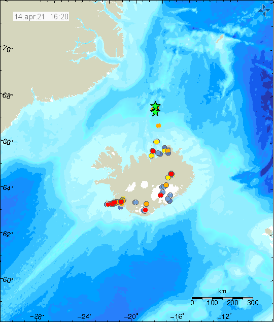
This morning (15-April-2021) more earthquakes where recorded far north of Kolbeinsey island. This activity is probably outside of Kolbeinsey ridge but I don’t know the name for this part of the north Atlantic ride. Largest earthquake took place at 09:29 UTC and had a magnitude of mb4,4 according to EMSC. Information about the earthquake can be found here.
Earthquake activity far north of Kolbeinsey island. Copyright of this image belongs to Icelandic Met Office.
It is not possible to know what is going on at this location. It is extremely remote and under 2 to 4 km deep ocean. If anything more happens at this location it is only going to be detected by seismometers.
Early morning (14-April-2021) an earthquake swarm took place far north of Kolbeinsey island. Largest recorded earthquake had a magnitude of Mw3,5 but it possibly was larger but because of distance from the SIL network the magnitude is underestimated. I did record this earthquake on my only seismometers and it showed a lot of surface wave activity, suggesting a larger magnitude than Mw3,5.
The earthquake swarm far north of Iceland. Copyright of this image belongs to Icelandic Met Office.
Because of remote location of this earthquake swarm it is not possible to know what is going on there. The area is also under an ocean that is 2 to 4 km deep at this location. If anything happens it is not going to be noticed outside of being detected with seismometers.
Donations
If you want to support my work it is possible to do so with the donation button or regular donations option. Thanks for the support. 🙂
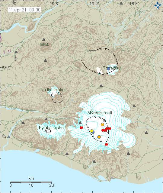
During the night of 11-April-2021 deep earthquakes took place in Katla volcano. Depth of this earthquakes was from 22,1 km to 24,5 km.
Deep earthquake activity in Katla volcano. Copyright of this image belongs to Icelandic Met Office.
All of the earthquakes where small in magnitude and none of them did get to magnitude of Mw1,0. Earlier in the morning a swarm of smaller earthquakes took place at shallow depth but those are probably not connected to this deep earthquake activity. This earthquake activity has stopped and I am not expecting anything more to happen.
This is a short article about the eruption in Fagradalsfjall mountain that is part of Krýsuvík-Trölladyngja volcano system.
This week has been busy and please read the older articles about what happened earlier in this week.
Lava output is now 50% more according to University of Iceland measurements compared to start of the eruption (19-March-2021). Gas output is also more then in start of the eruption. It has resulted in problems depending on wind direction.
There is a high risk that an eruption might start south of Geldingadalir valley eruption. There is also a high risk that new eruption is going to start north of the 5-April-2021 eruption.
There is no change in inflation in the area. It has slowed down but remains the same.
There continues to be low level earthquake activity along the dyke from Keili to Fagradalsfjall mountain.
Any change that is going to happen without warning and might not happen without any earthquake or little earthquake activity.
Next update is going to be on 16-April-2021 unless something major happens. This eruption is always changing and this weekend and next week might get interesting. If anything happens I am going to write new article soon as possible.
Update at 22:43 UTC
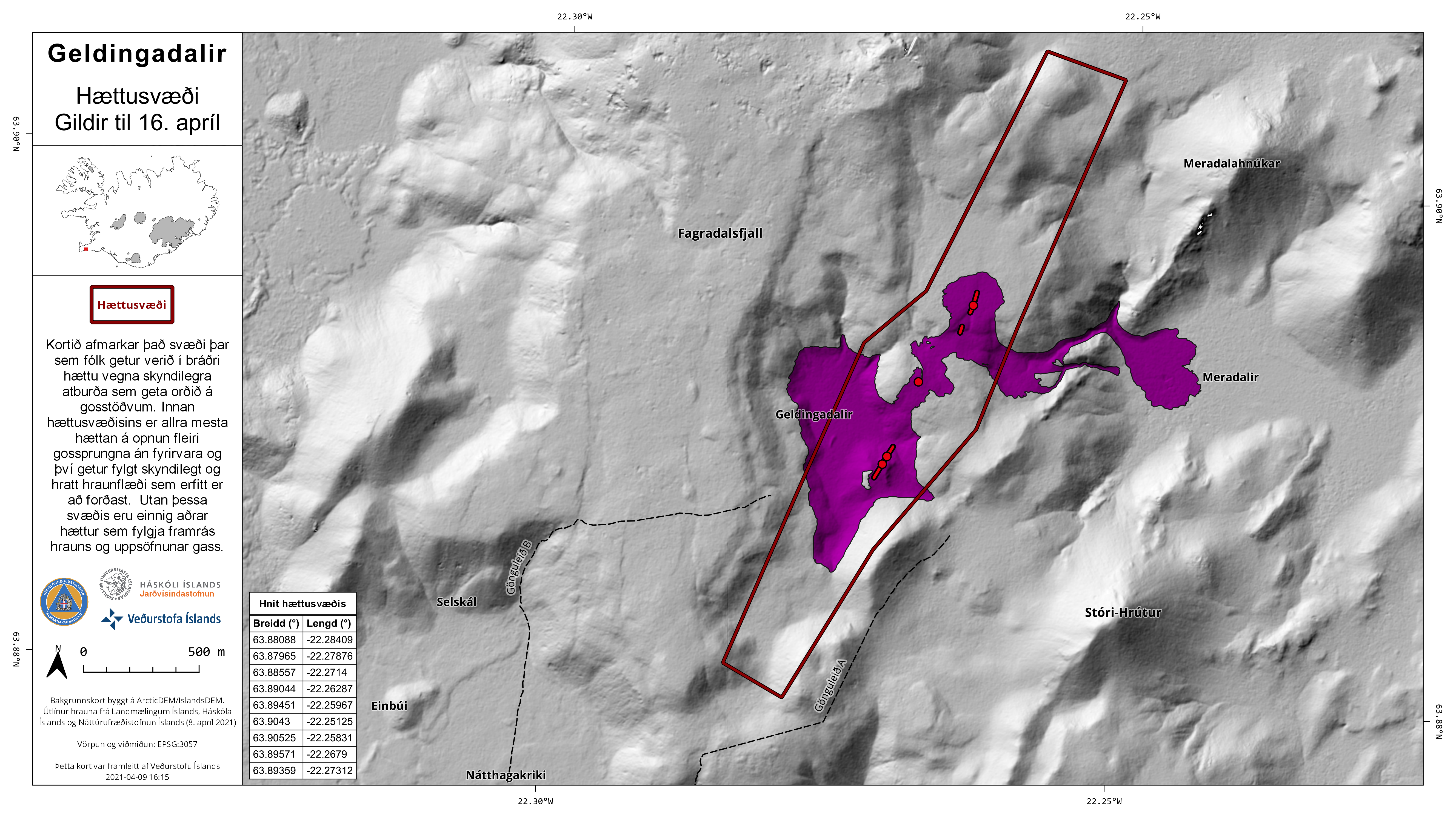
Icelandic Met Office released this map and press release (in Icelandic only) about the risk new fissures can open up both north and south the the current craters that are erupting. This page is updated regularly so if you are looking at this later than 9 to 10 April 2021 you might have to look for this information.
The new area that has a risk of new fissures opening up without warning. Copyright of this image belongs to Icelandic Met Office.
The map shows the area that is now at risk of new fissures opening up without warning.
Update 10-April-2021 at 15:20 UTC
Around 03:14 UTC on 10-April-2021 fissure number 4 did open up between fissure number 2 (5-April-2021) and fissure number 3. The eruption from this crater doesn’t seem to be large but it did happen under a new lava that had flowed over that same area few days before from fissure 2. In fissure/crater 1 the amount of erupting lava did drop a little just before the new eruption.
I am noticing that it seems new fissures are opening up more frequently then before. This seems to have changed after opening up of fissure 3.
Timeline of fissure openings so far.
1st fissure 19-March-2021
2nd fissure opened 5-April-2021
3rd fissure opened 7-April-2021
4th fissure opened 10-April-2021
Time period between new fissures opening up currently seems to be 3 to 4 days. I suspect that this is going to change soon and it is possible that new fissure that opens up might get larger as the eruption goes on. There seems to be phase in this eruption that is happening in Fagradalsfjall mountain. I am not perfectly sure what that phase is now since I’ve never seen this before and I don’t have any data on this type of eruption behaviour from other volcanoes outside of Iceland. That I know of.