Today (12-November-2021) at 15:16 and 15:35 two earthquakes with magnitudes of Mw3,3 and Mw3,6 took place in Bárðarbunga volcano.
Continue reading “Two strong earthquakes in Bárðarbunga volcano”

Volcano and earthquake activity in Iceland
Today (12-November-2021) at 15:16 and 15:35 two earthquakes with magnitudes of Mw3,3 and Mw3,6 took place in Bárðarbunga volcano.
Continue reading “Two strong earthquakes in Bárðarbunga volcano”
Today (12-November-2021) at 05:05 UTC an earthquake with magnitude of Mw3,2 took place 3,3 km South West of Keilir mountain. This earthquake was felt up to Borgarnes town.
Continue reading “Earthquake not far from Keilir mountain this morning”
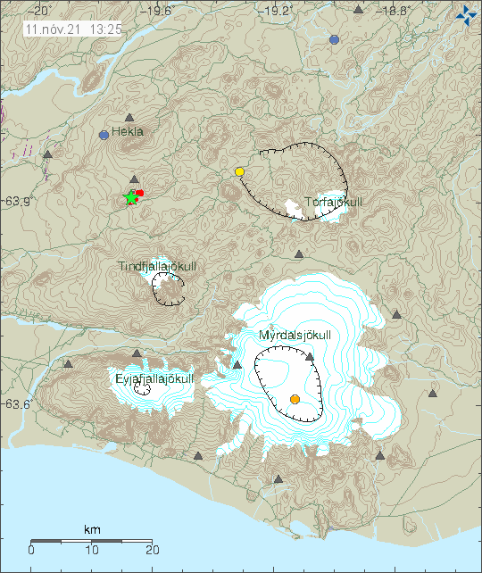
The earthquake today (11-November-2021) at 13:21 UTC with the magnitude of Mw5,2 seems to align it self with faults that are part of SISZ rather than being part of Hekla volcano system. The high frequency tone on 2 – 4Hz that I did see on few nearby SIL stations has started to lower again after the main earthquake. Earthquake activity in the area is currently dropping but it might increase again without warning.
Continue reading “Update on the Mw5,2 earthquake south of Hekla volcano”
This is early information but it seems that a magnitude Mw5,2 or larger earthquake took place in Hekla volcano system at 13:21 UTC. This might be a start of an eruption in Hekla volcano, but currently it is too early to know for sure. This is inside Hekla volcano system in a area called Vatnafjöll that have regularly erupted.
It is not possible to know what is going to happen next in this area. But there is a risk of a magnitude Mw7,0 earthquake. If that is going to happens is impossible to know.
Around 10:00 UTC this morning (31-October-2021) the earthquake activity of long period and low frequency earthquakes increased this morning in Torfajökull volcano. The current swarm now seems to be coming from the glacier part of the caldera, the earlier activity seems to have taken part some place in north part of the Torfajökull volcano caldera. Location of the this earthquake activity is difficult if not impossible because of the type of earthquake activity being generated in Torfajökull volcano.
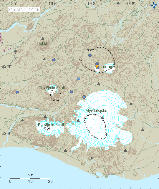
The situation is difficult to figure out just by looking at seismometer data. Icelandic Met Office is going to make a flyover today with the help of Icelandic Coast guard and try and see what is going on in Torfajökull volcano. Last eruption in Torfajökull volcano was in the year 1477 and I don’t have any idea what happens before an eruption in this volcano.
Yesterday (28-October-2021) an earthquake swarm took place east of Grímsey island. The largest earthquake had a magnitude of Mw3,9 at 22:06 UTC. It is not know if it was felt in Grímsey island.
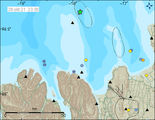
Earthquakes are common in this area and large earthquake swarm happens in this location every 2 to 10 years.
Yesterday (28-October-2021) two earthquakes with magnitude of Mw3,6 and Mw3,0 took place west of Kleifarvatn lake (in Krýsuvík-Trölladyngja volcano system). The first earthquake with magnitude of Mw3,6 took place at 18:36 UTC and the second earthquake with magnitude of Mw3,0 took place at 23:11 UTC. Other earthquakes that took place where smaller in magnitude.
This earthquake activity seems to be connected to magma movements in the area. It has not yet and might not result in a eruption since this is in a different fissure area. It is unlikely that this activity is connected to the magma movements that are ongoing close to Fagradalsfjall mountain.
According to an announcement made by Icelandic Met Office there has been a swarm of low frequency earthquakes in Torfajökull volcano since midnight of 28-October-2021. The earthquakes don’t appear clearly on the Icelandic Met Office map but they can be seen on nearby SIL stations. According to Icelandic Met Office the rate of earthquake activity is about 1 – 2 earthquake every 15 minutes.
There are two things that can create this type of low frequency activity. The first one is water that has been superheated in the crust. The second option is that magma is now moving in Torfajökull volcano. This type of activity has happened before without any eruption happening. I think that is going to be the same now at the writing of this article. Since this is an active volcano the situation can change quickly and without warning.
There are no web cameras in the area that I know of. It is remote and there is almost no mobile coverage at this location. If there is a mobile connection, it is limited to 2G (GSM) or slow 3G connection.
Earthquake activity continues close to Keilir mountain. But it remains at depth of 5 to 6 km and doesn’t show any sign that it is about to move to the surface. More than 10000 earthquakes have been recorded and 18 earthquakes have been recorded with magnitude above Mw3,0. This is according to Icelandic Met Office.
The eruption in Fagradalsfjall mountain (more information at Krýsuvík-Trölladyngja website at Global Volcanism Program) has not been active since 19-September-2021 and there are no signs that the eruption is about to restart soon. Global Volcanism Program no longer updates its information for this volcano as an active eruption. Icelandic scientists in eruptions have not declared the eruption over. It should be expected that the eruption in Fagradalsfjall mountain is over for now, but it can start again at the same location or at new location in few weeks time or maybe even few years from now.
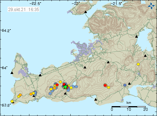
Yesterday (12-October-2021) an earthquake swarm took place in Reykjanes volcano. Largest earthquake in this swarm had a magnitude of Mw3,3 and the earthquake swarm was out in the ocean not far from the coastline.
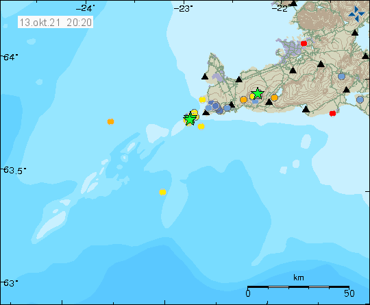
It is impossible to know for sure if this earthquake activity is directly connected to magma movements in this area. It is possible, but there have been some sign of magma moving in the crust in this area. The magma is moving but is not erupting or starting an eruption. Earthquake activity seems to be growing in this area of Reykjanes peninsula and Reykjanes ridge after the eruption in Fagradalsfjall mountain stopped.