
Today (8-December-2021) an earthquake swarm started north of Grindavík town. Largest earthquake in this swarm so far had a magnitude of Mw3,1 at 10:44. The news doesn’t say if this earthquake was felt in Grindavík. Earthquake activity has been going up recent weeks since the eruption in Fagradalsfjall ended on 18th September 2021. A swarm of smaller earthquake activity is currently ongoing in this same area at the writing of this article.
Continue reading “Earthquake swarm north of Grindavík town”
Large earthquake swarm in Reykjanes volcano
Yesterday (20-November-2021) an large earthquake swarm started in Reykjanes volcano. This earthquake swarm is rather large, with 217 earthquakes recorded so far. Largest earthquake had a magnitude of Mw3,5 but other earthquakes have been smaller in magnitude.
Continue reading “Large earthquake swarm in Reykjanes volcano”
Earthquake swarm in Reykjanes volcano
Yesterday (12-October-2021) an earthquake swarm took place in Reykjanes volcano. Largest earthquake in this swarm had a magnitude of Mw3,3 and the earthquake swarm was out in the ocean not far from the coastline.
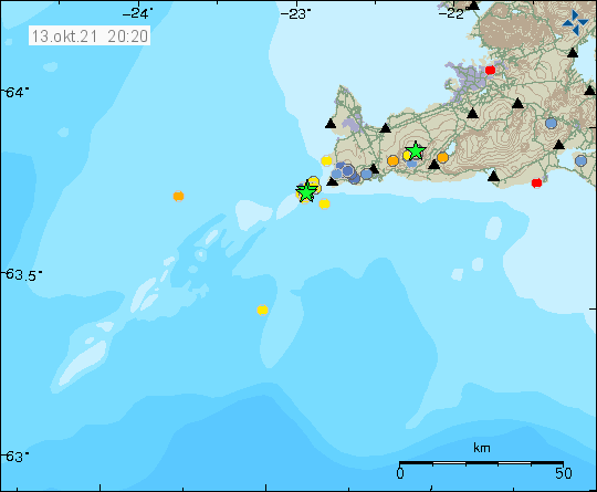
It is impossible to know for sure if this earthquake activity is directly connected to magma movements in this area. It is possible, but there have been some sign of magma moving in the crust in this area. The magma is moving but is not erupting or starting an eruption. Earthquake activity seems to be growing in this area of Reykjanes peninsula and Reykjanes ridge after the eruption in Fagradalsfjall mountain stopped.
Earthquake activity in Reykjanes volcano
During the night and today on 5-Augustu-2021 an earthquake swarm took place in the Reykjanes volcano.

Largest earthquake in this swarm had a magnitude of Mw3,0 and other earthquakes at the writing of this article have been smaller. That can change without warning. Currently there is a possibly that this earthquake swarm is over.
Donation
Please remember to support my work with donations. It helps me keeping my self and this working going on. Thanks for the support. 🙂
Earthquake activity north of Grindavík town in Reykjanes volcano
Early morning of 11-July-2021 an earthquake swarm took place north of Grindavík town. Largest earthquake in this swarm had a magnitude of Mw2,5. Most of the other earthquakes had a magnitude of Mw0,0 to Mw1,0. There was also an earthquake swarm on Reykjanestá area that is part of Reykjanes volcano.
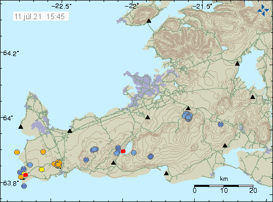
It is difficult to know for sure what this earthquake activity means for this volcano. Since it has already been proven that eruption activity can start on Reykjanes peninsula without any warning or earthquake activity. Currently there are no clear indicators that suggest anything is about to happen but that can change without warning.
Donations
Please remember to support my work with donations. Thanks for the support. 🙂
Strong earthquake in Reykjanes volcano 5 km north of Grindavík town
Yesterday (20-April-2021) at 23:05 UTC an earthquake with magnitude Mw4,1 took place and was felt over a wide area and in Reykjavík. At 21:20 UTC and earthquake with magnitude of Mw3,1 took place and at 23:29 UTC an earthquake with magnitude of Mw3,2 took place. Earthquake activity has continued today with smaller earthquakes and several earthquakes with magnitude above Mw2,0.
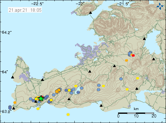
This earthquake took place in the volcano Reykjanes based on location on the map. The map is slight unclear on the location of the Reykjanes volcano and what volcano is exactly there but this is based on best possible assumption that I can do. More earthquake activity in this area or close to it is a high possibility.
Donations
It is possible to support my work by using the PayPal button on the website. Thanks for the support. 🙂
Earthquake swarm in Reykjanes volcano early morning of 19-March-2021
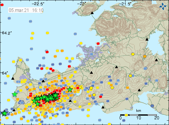
At 04:30 this morning (19-March-2021) an earthquake swarm started just off the coast of Reykjanestá. This activity looks tectonic in nature for now but it is highly focused in one location. This earthquake activity did start on 24-February-2021 when the Mw5,7 earthquake happened. This activity was only going on for short period of time on 24-February-2021 before it stopped until now.
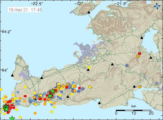
Largest earthquakes in this swarm had a magnitude of Mw3,7 but in total of 10 earthquakes with magnitude above 3 took place in this earthquake swarm. Around 100 earthquakes where recorded at the writing of this article but after 06:00 this earthquake swarm slowed down from its peak activity around 05:50. This earthquake swarm might increase again without warning.
New information about the situation in Fagradalsfjall volcano
This is a short article about the new information published today (8-March-2021) by Icelandic Met Office and Department of Civil Protection and Emergency Management.
New measurements of the situation in Fagradalsfjall volcano show that the dyke intrusion continues to grow and as at its shallowest point at 1 km depth. Possible eruption is expected at the south end of the dyke intrusion (closest to Fagradalsfjall mountain). Earthquakes are going to happen at the south-west end of the dyke and north-east of the dyke because of the inflation the magma is creating in the area.
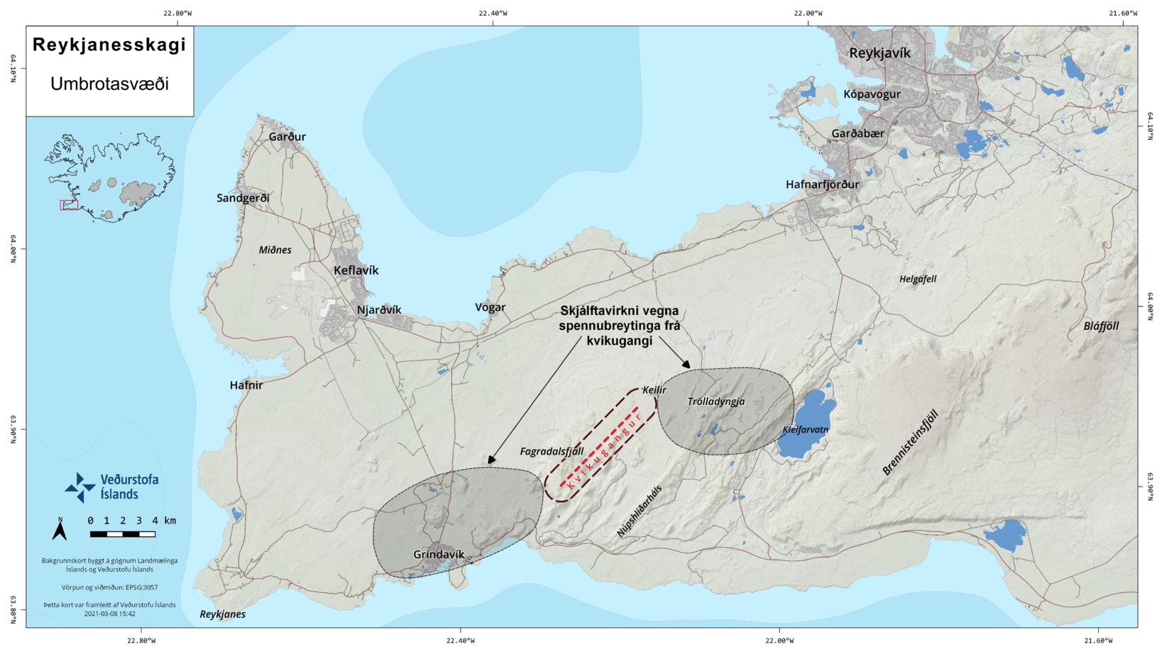
There are going to be quiet times between high period of activity according to the news about this activity. There is also ongoing risk of a earthquake with magnitude of Mw6,5 in Brennisteinsfjöll volcano and according to Icelandic Met Office that risk has not been reduced in recent days. Outside of the Fagradalsfjall volcano magma dyke, no magma movement has been detected in Reykjanes (Svartsengi?) volcano and in Krýsuvík volcano.
Sources (Icelandic)
Áfram má búast við að virknin á Reykjanesskaga verði kaflaskipt (Iceland, English, Polish, Almannavarnir.is)
Kvikan er á kílómetra dýpi (Rúv.is, Icelandic)
Update on activity in Fagradalsfjall and Reykjanes volcanoes
This is a short update on what is going on in Reykjanes peninsula. This article is written at 16:29 UTC.
Volcanoes in this article
Fagradalsfjall
Reykjanes
Krýsuvík
- Fagradalsfjall volcano has not erupted since Pleistocene. When last eruption took place is not listed or not known. This the first magma movement in Fagradalsfjall volcano in 11700 years.
- Eruption risk is now in Reykjanes volcano*.
- *This might also be a different volcano known as Svartsengi (no Global Volcanism Profile). There is no agreements between maps on this detail for now. Reykjanes volcano might only extend into Reykjanestá and then is mostly under ocean and might not extend into Reykjanes peninsula as sometimes is shown on maps.
- Krýsuvík volcano has quieted down a little in the last 24 hours. Eruption risk is lower for now in that volcano.
- Largest number of earthquakes detected in one day was over 3000 earthquakes.
- In the last 24 hours 12 earthquakes with magnitude above Mw3,0 have happened. Most of them are felt in nearby populated areas.
- No harmonic tremor has been detected since it ended during the night on 4-March-2021.
- During the last 48 hours over 3300 earthquakes have been recorded by Icelandic Met Office.
- New! Magma is now estimated to be at 5 to 6 km depth but might be as shallow as 2 km depth.
Maps of possible eruption areas has been made by Earth science department of University of Iceland and can be found here. University of Iceland Earth science department also made a lava flow prediction can that map can be found here. Both maps are updated daily on Facebook.
Web cameras
Beint vefstreymi af skjálftasvæðinu – Vogastapi (Rúv.is)
Keilir í beinni (mbl.is)
Óróasvæðið í beinni útsendingu (Vísir.is)
Live from Iceland
Keilir og skjálftasvæðið (YouTube)
Added at 21:12 UTC
Road camera 1
Road camera 2 (night vision/infrared)
Cameras and links might go offline without warning.
Donations
It is possible to support my work with donations. It helps me in current financial situation that has remained rather bad. You should only donate if you can. Other ways to support my website is to let people know about it if they are interested in earthquakes, volcanoes and geology in Iceland. Thanks for the support. 🙂
Article updated at 16:53 UTC.
Article updated at 21:13 UTC.
Update on activity in Fagradalsfjall, Krýsuvík, Reykjanes volcanoes
The situation on Reykjanes peninsula is getting complicated due to activity between three volcanoes. This article is written at 15:22 UTC.
The volcanoes that are now showing activity on Reykjanes peninsula
Reykjanes volcano
Krýsuvík volcano
Fagradalsfjall volcano (added from 04-March-2021)
Fagradalsfjall volcano has no document eruption history over the last 10.000 years and the main volcano location is unknown if it exists.
Updates from the last few hours
- Small rift valley has started to form between Keili mountain and Fagradalsfjall mountain. This is part of the rift zone that is Reykjanes peninsula.
- Harmonic tremor stopped this morning and as Icelandic Met Office has been telling the news the origins of this harmonic tremor was earthquake activity that was so dense it created this harmonic activity. In the morning the activity dropped a little.
- Magma continues to move in the Fagradalsfjall volcano system.
- Earthquake activity is now between the volcanoes Reykjanes, Fagradalsfjalls and Krýsuvík. Why that is unclear but magma movement for now is only in Fagrdalsfjall volcano system.
- Largest earthquake in last 24 hours had a magnitude of Mw4,5. Over the last 48 hours total of 72 earthquakes with magnitude over Mw3,0 have taken place. There is no sign of activity slowing down.

It is currently impossible to know for sure what happens next since this situation is extremely complicated because of all the volcanoes interactions and earthquake activity.
Live internet broadcasts of Keilir
Beint vefstreymi af skjálftasvæðinu – Efstaleiti (Rúv.is)
Keilir í beinni (mbl.is)
Keilir og skjálftasvæðið (YouTube)
If anything major happens I am going to post update soon as possible.
Article updated at 15:38 UTC.