Minor earthquake swarms in Iceland

It has been quiet in Iceland during the past few weeks. Besides activity in Katla volcano and Kolbeinsey ridge. Nothing of interest has been going on in Iceland. Here is however the overview of activity in Iceland during the past few hours.

Kolbeinsey Ridge

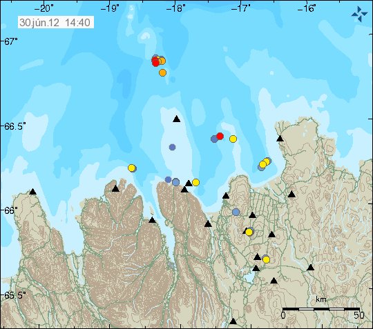
Some minor earthquake activity has been taking place in Kolbeinsey Ridge during the past few hours. This earthquake swarm is small in nature, with largest earthquakes reaching the magnitude 2.4. Otherwise it remains quiet in this area.


Earthquake activity in Kolbeinsey Ridge. Just north of Grímsey Island. Copyright of this image belongs to Iceland Meteorological Office.

Kolbeinsey ridge has seen some activity during past few weeks. But it might just be normal tectonic earthquakes taking place. So far nothing suggest any volcanism nature of this earthquake activity.

Krýsuvík volcano

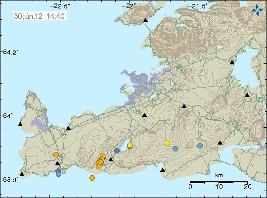
During the past few hours. Krýsuvík volcano did see some earthquake activity. This activity is most likely to be tectonic in nature. As Reykjanes peninsula has frequent earthquake swarm that are tectonic in nature.


Earthquake swarm on Reykjanes. It is located within Krýsuvík volcano. This was small earthquake swarm. Copyright of this image belongs to Iceland Meteorological Office.

It remains rather quiet on Reykjanes besides this minor earthquake swarm today.

Katla volcano

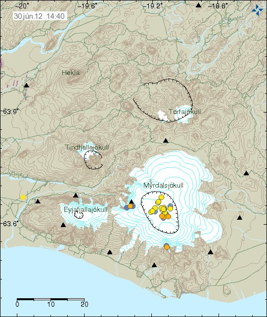
After rather interesting activity during the past few weeks. It seems that Katla volcano is slowing down in earthquake activity. For now at least. But it is impossible to know for sure if current quiet sense is going to continue in Katla volcano.


Earthquake activity in Katla volcano during past few days. The activity is mostly concentrated into Katla volcano caldera. Copyright of this image belongs to Iceland Meteorological Office.

Besides this top of the activity. All is quiet in Iceland. Both in volcanoes and earthquakes. That might however change at any time without warning. It happens often in Iceland. I also want to remind people of my geophone web page. Where earthquakes can sometimes be seen soon after they have taken place.

Krísuvík volcano inflates and deflates regularly

It seems that Krísuvík volcano is inflating and deflating on regular basic. I do not know how regular this change is. But it has been noticed by Icelandic scientists how are bit puzzled by this behavior. Last inflation episode did last until end of the year 2011. Since then deflation did start again and is currently ongoing. It is uncertain if what this means. At the moment it is too early to know for sure if this means if that Krísuvík volcano is getting ready for an eruption. But if there was an eruption in Krísuvík volcano, it would be Hawaiian eruption so no volcano ash. Volcano ash eruption would only take place if an eruption started in Kleifarvatn lake. But the effects of that would be limited to local area (Reykjavík and other nearby towns). It would not create any global problems, as many would want to believe.

Inflation and deflation period have been the years 2009, from January to September. In May 2010 inflation did start again, that inflation period lasted until end of the year 2011. Since then deflation has been taking place. Today there is continues GPS monitoring in Krísuvík volcano. But it is unknown if this type of behavior has taken place before in Krísuvík volcano. But for now Krísuvík volcano is being monitored both with GPS and the SIL network. What happens next anyone guess.

Icelandic news about this.

Land rís og sígur í Krýsuvík (Rúv.is)

Minor earthquake activity in Iceland

During the past few weeks it has been quiet in Iceland. Really quiet, with almost nothing going on. It is still like that to some extent. So this is just a short overview of the small activity that has been taking place in Iceland during the past 48 hours or so.


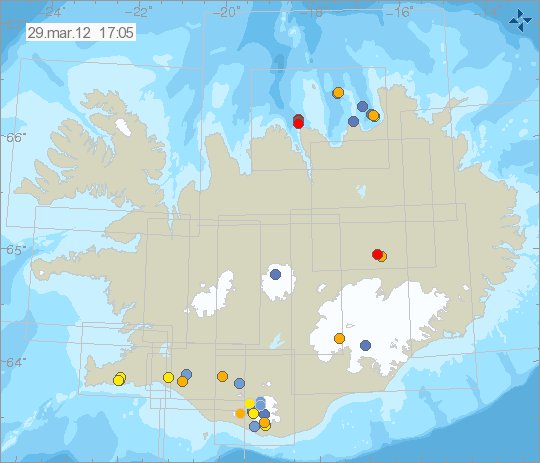
The earthquake activity in Iceland during the past 48 hours. Copyright of this image belongs to Iceland Met Office.

The most activity in the last 48 hours have been on the Reykjanes and on TFZ. But there was an small earthquake swarm in each area. With earthquakes that did not get over ML2.5 in size so far. Two earthquakes where in Askja volcano. One in Grímsfjall volcano fissure system (maybe in Þórðarhyrna volcano).


Earthquake west of Hekla volcano, in the SISZ. This picture is released under Creative Common Licencee. See the licence page for more detail.

Katla volcano

During this winter. Katla volcano has been quiet. This is somewhat normal, as more snow means more ice-mass on top of the volcano. But now that has started to melt a little and that means less ice-mass on top of the volcano. That could mean more activity in Katla volcnao during the next few weeks. So far however the activity remains small and there are no special earthquakes to report.


Earthquake activity in Katla volcano, on this picture earthquake activity west of Hekla volcano can also been seen here. Copyright of this image belongs to Iceland Met Office.

The earthquakes west of Hekla volcano belong to the SISZ fault area. Not Hekla volcano it self. What is also interesting is the earthquake activity in south part of Katla volcano. In area outside of the glacier. This are small earthquakes, that do not appear on my geophone. Even if they are close to it. I am unsure what this means for the future. But it is worth keeping an eye on it.

Analysis of the Helgafell mountain earthquake on Reykjanes

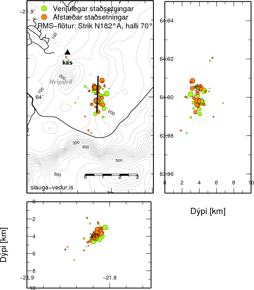
Icelandic Met Office has posted an interesting analysis of the last weeks earthquake on the Reykjanes. But this earthquakes where connected to Krýsuvík volcano activity. By relocating the earthquakes, it is possible for Iceland Met Office to see better how long and how deep the fault that created this earthquakes is. In this case, it was around 2 km long and the movement was east-west, like the one found on SISZ.


The re-located earthquakes. The green ones are normal locations, the orange ones are re-located earthquakes. Copyright of this image belongs to Iceland Met Office.

The orange ones are re-located using relative locations. I am not sure how this technique works. But it often gives better image on what is going on with the earthquakes. Both in terms of the fissure making the earthquakes and the depth where they are taking place.

The fissure in question was on N-S axes and is inclined about 70° in west direction. According to IMO, the aftershocks suggest that movement of this fissure was right slip, along with minor drop in it. That means this according to IMO. The west part of the fissure moved to north and down, while the west part of the fissure moved to the south and little bit upwards. According to IMO. This movements happens in SISZ on large fissures there (when they break).

I am currently waiting for more earthquakes in this area. This activity is not over in my opinion any time soon.

Source of data: Week 9 – Iceland Met Office (Icelandic).

Other: I am sorry for lack of updates. There has not been anything special going on and I have been working on confirming getting an apartment in May 2012.

Blog post updated at 09.03.2012 at 17:37 CET. Fixed spelling error.

More earthquakes should be expected on the Reykjanes

The earthquake swarm on the Reykjanes has slowed down considerable since it did start yesterday. But it is still ongoing in my opinion. Even if there are no earthquakes currently taking place at the moment. There are several reasons for this. The biggest one is that this area seems to be getting more active now then it has been for many decades now. The fissure that is currently moving is connected to Krýsuvík volcano, but this was reported in the news. I do not know every fault line in this area and how they are connected (plus, my volcano map is in an box until I move back to Denmark) together. But I do know that

During the past 2 to 3 years the volcano Krísuvík has been showing more activity. With inflation and deflation episodes that lasts from few days to weeks at the time. Followed by an earthquake swarms both before and after each episode of activity. This activity seems to be increasing, at least that is my opinion on what is happening at the moment.

While this earthquake swarm is still ongoing. It might have long periods of no activity at all. This is common for faults that have not moved in an long time. As seems to be the case in Helgafell mountain and nearby area. But the fault lies close to that mountain or under it (I am not sure). But this started this year with an magnitude ML3.2 earthquake in this area earlier this year.

It is hard to know exactly when next episode of this activity is going to continue. But I am sure that it is going to be soon.

Earthquakes in north and south Iceland [Updated]

This evening has been busy in Iceland. There was an ML3.5 earthquake just outside an area called Gjögurtá (part of TFZ). Followed by an ML3.2 aftershock. Earthquake activity seems to have stopped there for the moment. This took place at 22:06 UTC on 29.02.2012. The largest earthquake was felt over an large area that was closest to its location.


The location of the earthquake in the TFZ. Copyright of this picture belongs to IMO.

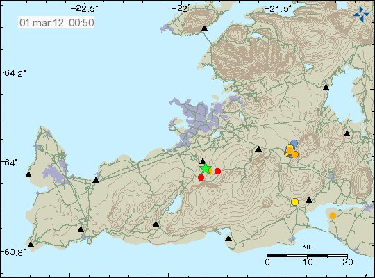
At 00:29 UTC on 01.03.2012 there was an earthquake on the Reykjanes. It happened in an mountain called Helgafell. Early results suggest that this earthquake had the size of ML3.2. It was felt over an wide area in south Iceland. Aftershocks are currently taking place, and more large earthquakes in this area cannot be ruled out at the moment.


The earthquake location on the Reykjanes. Copyright of this picture belongs to IMO.

There is an chance for more earthquakes in Reykjanes. As earthquake swarms in this area of Iceland can often be tense and make many earthquakes that have magnitude 3.0 and stronger.

This earthquake activity appears clearly on my geophones in Iceland. They can be viewed here and are updated every 5 min.

Update 1: More strong earthquake activity is taking place on the Reykjanes at this moment. The largest earthquake so far is ML3.9 according to the automatic data from IMO.

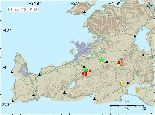
Update 2: Here is the image from Iceland Met Office of the area where this earthquake activity is taking place.


The current earthquake activity on the Reykjanes. Copyright of this picture belongs to IMO.

Update 3: The size of the second earthquake has been upgraded to ML4.2. Some minor damage has already been reported according to new from Rúv.

Blog post updated at 01:14 UTC on 01.03.2012.
Blog post updated at 01:39 UTC on 01.03.2012.
Blog post updated at 01:52 UTC on 01.03.2012.

Icelandi News about the earthquake in north Iceland. All news are in Icelandic.

Jarðskjálfti upp á 3,5 út af Gjögurtá (mbl.is)
Snarpir skjálftar fyrir norðan (Vísir.is)
Skjálfti út af Eyjafirði (Rúv.is)

News about the earthquake on the Reykjanes. All news are in Icelandic.

Skjálftakippur á höfuðborgarsvæðinu (Rúv.is)
Jarðskjálfti fannst vel á höfuðborgarsvæðinu (Vísir.is)
Jarðskjálfti við Helgafell (mbl.is)

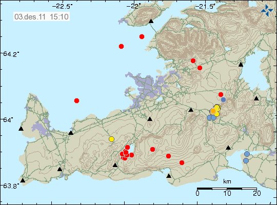
A ML3.6 earthquake in Krísuvík volcano (automatic size)

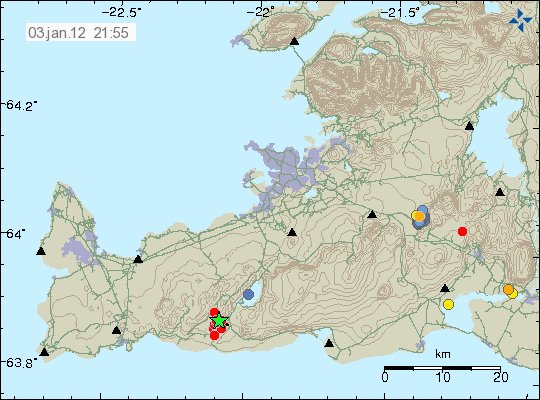
At 21:12 UTC on 3. January 2012 an earthquake with the automatic size of ML3.6 did happen in Krísuvík volcano. I do not yet know if this earthquake was felt in the nearby area. But I assuming that it has done so.

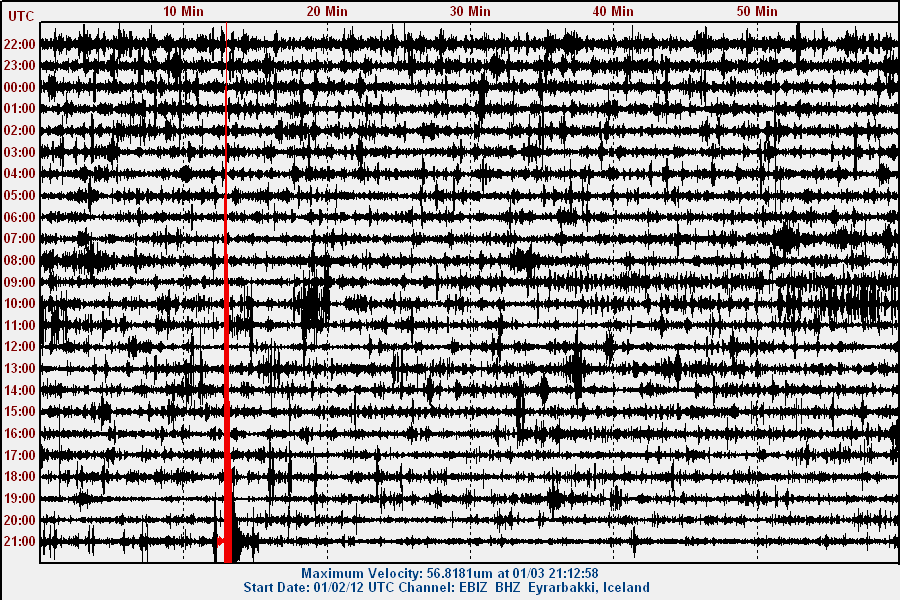
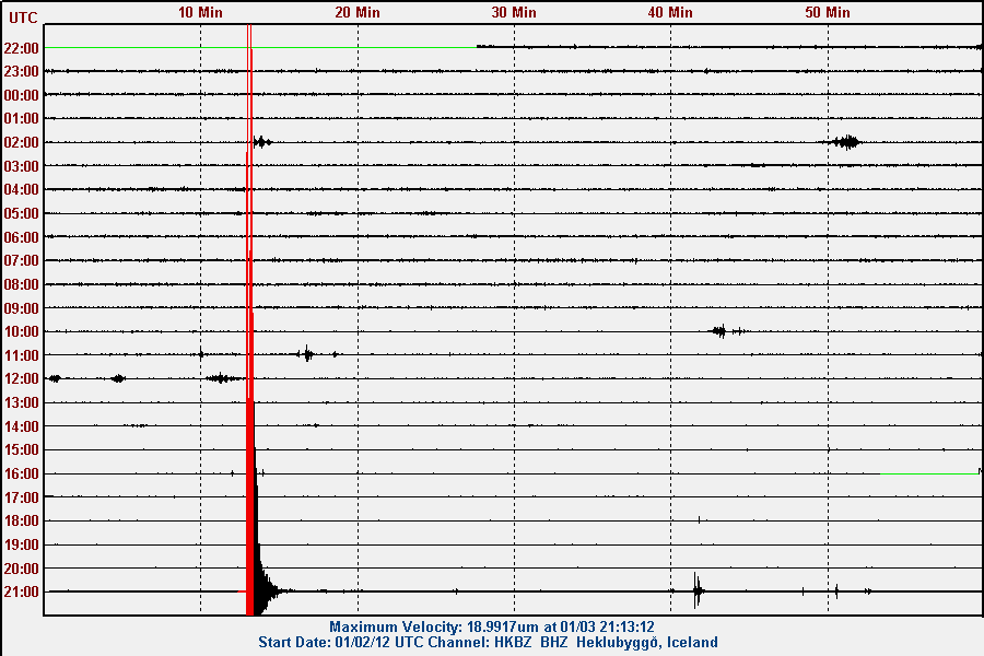
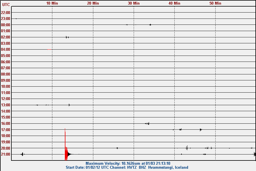
This earthquake did appear clearly on my geophones. Both in north and south Iceland. They can be viewed here. I am going to update this blog post as I know more. But this seems to be an start of earthquake swarm in Krísuvík volcano.

Update 1: It has been confirmed that this earthquake was felt in Reykjavík and nearby area. The automatic depth of this earthquake was 14.2 km according to Iceland Met Office.

Update 2: Earthquake swarm has started in Krísuvík volcano. The largest earthquake in this earthquake swarm after the main earthquake is ML1.1 in size. Larger earthquakes however might happen at any time in this earthquake swarm. But that is at least the experience so far.

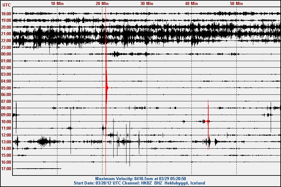
Update 3: Here are the traces of the earthquake. Sorry. But for the moment there are no high resolution pictures available as my main earthquake computer is offline until I move back to Denmark. See this blog post here for more details on that.


The location of the ML3.6 to ML3.7 earthquake in Krísuvík volcano. Copyright of this picture belongs to Iceland Met Office.


The ML3.6 earthquake as it did appear on Eyrarbakki geophone. This picture is released under Creative Commons Licence. Please see the CC Licence web page for more detail.


The ML3.6 earthquake as it did appear on the Heklubyggð geophone. This picture is released under Creative Commons Licence. Please see the CC Licence web page for more detail.


The ML3.6 earthquake as it did appear on the Hvammstangi geophone. This picture is released under Creative Commons Licence. Please see the CC Licence web page for more detail.

Blog post updated at 21:38 UTC.
Blog post updated at 21:45 UTC.
Blog post updated at 22:15 UTC.

Growing earthquake swarm in Krísuvík volcano

There seems to be a growing earthquake swarm in Krísuvík volcano on the Reykjanes peninsula. The strongest earthquake so far is a ML2.2 according to the automatic size estimate. Some ghost earthquakes appear to be outside a town called Akranes and Reykjavík to the north. But that are earthquakes that are in fact nothing but errors. This earthquake swarm is tectonic in nature, not volcanic. So there is not going to be a eruption in Krísuvík volcano from what I can tell at current moment.


The earthquake swarm in Krísuvík volcano. Copyright of this picture belongs to Iceland Met Office.

It is hard to know how this earthquake swarm is going to develop. But this earthquake swarm looks growing. For that it is going to peak in activity sometimes in the next few hours. But when exactly is hard to know for sure. I am going to update this blog post if something major happens. The strongest earthquakes appears on my geophone and can be viewed here.

Update on the weekend activity

Iceland

This weekend was quiet in Iceland. There was almost nothing going on. There was only one small earthquake swarm in Krýsuvík volcano. But this earthquake swarm was tectonic in nature, not volcanic. The largest earthquake in this earthquake swarm was about ML3.2 in size. Few earthquakes where in Katla volcano, but less this weekend then many others. But it is normal for Katla volcano to be quiet during November to March each year due to snow that is added to the glacier. But that increased the pressure of the glacier on top of the magma chamber (floating balance laws at work here).

Mainland Spain

There was a flurry of earthquakes on Mainland Spain during the weekend. None of this earthquakes where felt, from what I can gather at IGN web site.

Canary Islands, Spain

The eruption at El Hierro volcano continues as it has done for the past almost two months now. The harmonic levels are about the same as it has been, but there seems to be minor intermittent in activity from El Hierro volcano. IGN has setup a picture web site with images that show the activity since this eruption started clearly.

Erik at Eruption blog has good blog post about the magma mixing that appears to be taking place in the eruption in El Hierro volcano.

Other then this. Is is all quiet in Iceland for the moment. But frost-quakes should be expected in the next 48 hours or so in Iceland. As the ground freezes over in a really cold weather.

Few right and wrong things about geology in Iceland, part 1

I have seen many speculations on how geology works in Iceland. Some of it is good and based on observation and factual basic. Other however is nothing but speculation and far from anything based on factual evidence on how geology works in Iceland.

Few right and wrong things about volcanism in Iceland

Volcano interaction Status: Limited truth to this

Volcano interaction is something of a debated among scientists. But what is not debated is the interaction between volcanoes that lies far apart. That interaction is none by it’s nature. So while I have been seeing discussion in the comments here that there is some connection between activity between Hengill volcano and Hekla volcano. This is untrue. There is no connection between those volcanoes and never has been. The reason is simple. The volcanoes are far apart. They don’t even share the same magma source. But that is evident by the lava that comes from this two volcanoes. But Hekla volcano has mixed types of eruption sometimes. But Hengill volcano only has Hawaii styles eruptions (if not hit by water) when it erupts, in style with other volcanoes on the Reykjanes ridge rift zone.

The only real life examples of volcano interaction are from Bárðarbunga volcano and Torfajökull volcano. The reason for this interaction is quite simple and logical one. Bárðarbunga fissure swarm cuts right trough Torfajökull volcano. When magma travels south-east in the fissure swarm (it last happened in the 15th century) it can hit the magma inside Torfajökull volcano. When this happens there is a big bang in Torfajökull volcano. As the magma in Torfajökull volcano seems to be colder and more Intermediate (andesitic) [link, Wikipedia] in nature. But in Bárðarbunga volcano the magma is Mafic (basaltic) in nature. When the two magmas mix, it ends with a bang and eruption in both volcanoes. But normally the process that starts this is because there is a ongoing eruption in Bárðarbunga volcano. So when Bárðarbunga volcano. I would worry about that rather then anything else.
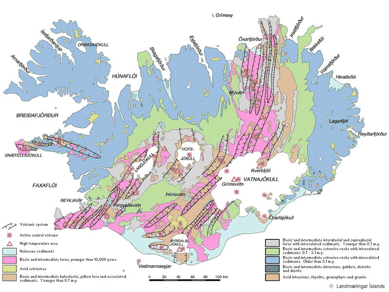

See, no connection at all between Hekla and Hengill volcano. Copyright belongs too this picture owner. Owner unknown to me.

Iceland is going to have VEI-8 eruption. Status: Not likely.

All volcanoes can do a VEI-8. But the thing is that they are just not likely to do so. As the size of the eruption is directly connected to the inflow of magma it is getting. In the case of Icelandic volcanoes the inflow just seems to be few magnitude too small to make a VEI-8 eruption. The largest VEI eruption known in Iceland was a VEI-6 eruption that took place in Bárðarbunga volcano in the year 1477 (?).

As for VEI-8 eruption. I am not expecting that type of eruption any time soon in Iceland.

Iceland is one volcano. Status: False.

The simple answer is no. The long answer is. Iceland has many volcanoes, not just one. So the answer is no to this.

Geology in Iceland is well understood. Status: False

Geology in Iceland is understood. But far from being fully understood. As it happens geology science is just starting to now understand what complex progress are taking place in Iceland. A lot have been learned. But a lot more needs to be learned about how geology works in Iceland.

Volcano eruptions comes in active cycles. Status: True

This has been observed by actual data. But volcano activity happens in periods of 80 to 160 years. With a quiet period of 50 to 90 years. But numbers are approximation. During the quiet time there are fewer eruptions and they are smaller (hint: Large eruption can still happen however during the quiet period). Last quiet period started in around the year 1870 and did not end until the year 1983. But that year there was a eruption in Grímsfjall volcano. But then Grímsfjall volcano had not erupted since the year 1954, but that break was 29 years long for Grímsfjall volcano.

This graph here also shows this clearly. But this is volcanism in Iceland during the years 1875 and to the year 1993.
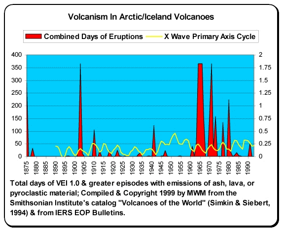

Copyright holder unknown. Copyright of this picture belongs to this owner.

It is impossible to know for sure when the high peak in the current cycle is going to be be. But most geologist are estimating that to be sometimes from the year 2020 and to 2080 or about that. So the years ahead is going to be quite busy in Iceland in the terms of volcano activity.

I am going to write more right and wrongs about Icelandic volcanoes soon. But for now this is good enough.

Sources and other things.

Volcano-tectonic Interaction in the Hengill Region, Iceland during 1993-1998 (pdf)
Volcano geodesy and magma dynamics in Iceland (ScienceDirect)
Interaction between Continental Lithosphere and the Iceland Plume—Sr-Nd-Pb Isotope Geochemistry of Tertiary Basalts, NE Greenland
Tomographic evidence for a narrow whole mantle plume below Iceland (ScienceDirect)
Pdf document on Hengill volcano crustal deformation.
Magma (Wikipedia)
Volcano geodesy and magma dynamics in Iceland (pdf)