This information is going to go outdated quickly.
This is the current information about the eruption in Bárðarbunga volcano.
Please note: Since I cannot go to the area that is erupting my self (it is closed and I also live in Denmark at the moment). I have to relay on what is being told in the news and released by Icelandic Met Office along with other data. This means that I spend most of the day collecting data and working out what is going on (my view in most cases). This means that in most cases I write post late in the day when daily observation is done.
Current status of the eruption in Bárðarbunga volcano
- New fissure did open around 2 – 3 km south of the eruption fissure that started erupting 31-August-2014.
- Comments on this website did notice the eruption around 04:00 UTC on 05-September-2014. At the same time there was an minor increase in harmonic tremor on SIL stations close to the eruption.
- The new eruption fissure is around 1 – 2 km long. It might get longer as time passes.
- The new eruption was first reported by the press around 06:00 – 08:00 on Rúv.
- New cauldron has formed some 6 km in Dyngjujökull glacier. The glacier in the that area is 300 to 350 meters thick. Last report was that this cauldron was getting deeper during the day.
- Higher conductivity has been reported in Jökulsá á fjöllum glacier river. That is currently continuing on that last check I did on Icelandic Met Office website.
- Smell of rotten eggs is now coming from Jökulsá á fjöllum. Normally there is no such smell of that glacier river.
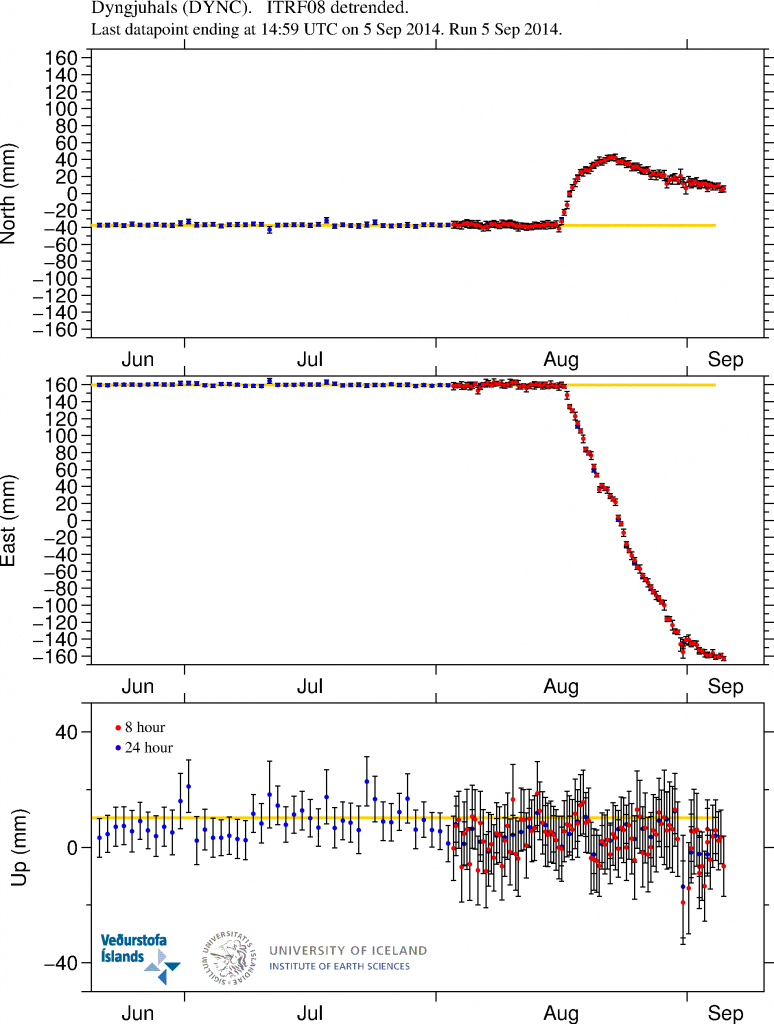
- Inflation in the dyke continues, not on the same speed as before, but it is ongoing.
- The rift valley appears to continue expand were he is visible.
- The air around the eruption site is toxic due to release of SO2, CO, CO2, fluorine gases and other dangerous gases.
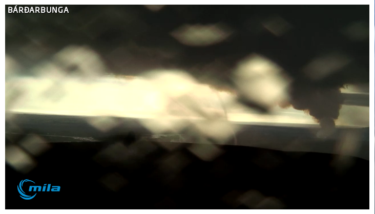
- The water vapour cloud goes up to 4,5 km according to latest measurements.
- The SO2 goes the way of the wind direction at any given time.
- The lava field has just 1 km to Jökulsá á fjöllum glacier river. Once the lava enters the river it might start to build a dam and the lava is going to explode and steam a lot in the process.
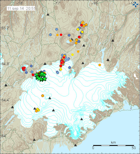
- Largest earthquake since midnight was magnitude 5,3 that took place at 01:19 UTC. It took place in Bárðarbunga volcano caldera rim. As other large earthquakes since this events started.
- Largest earthquake in the dyke area took place at 14:31 UTC and had the magnitude of 3,2. It was under the glacier were most earthquake activity is now taking place.
- Volcano eruption with ash cloud is now expected to take place. When and exactly where it is going to take place is not known at current time. I don’t think it going to have effects on international flight. But the local effects might be big if wind is in the direction of populated areas of Iceland.
GPS inflation

GPS measurements of the inflation that is currently taking place in the dyke. More GPS data can be found here. Copyright of this image belongs to University of Iceland.
Magma continues to flow into the dyke. It is at slower rates than before, but it still flowing into the dyke at rates that current eruption is not powerful enough to equal or drop the pressure inside the dyke. This is going to result in more eruptions as we have already started to see. When and where they are going to take place is something that is not known.
The eruption area is closed to the public
Due to risk of dangerous gases and flood the eruption area is closed to the public. Anyone that is found within the closed zone is going to get heavy fine. Going to this area is also extremely risky sine the area that is now eruption is extremely unstable with the risk of new eruption opening up without warning in the fault area and even outside it (if there is a weakness in the crust the magma is going to go that way). Police in Iceland have already spotted and fined two cars that were trying to enter the closed off area. This area of Iceland is also out in the middle of nowhere. The town is up to 10 hours away in a car (due to bad roads). Weather is also extremely unpredictable and can change without warning. So if you are thinking about going on car or foot. Don’t go!
The good news is that it is still allowed to fly over the area. So get one of those tours. I don’t know what they cost, but I know they take place if weather allows.
News bits
Arrested near the Holuhraun eruption (Rúv.is)
See the lava creeping forward at Holuhraun (Rúv.is, video)
The powers at play beneath the surface (Rúv.is, video)
More news in English can be found here (Rúv.is).
Updates for 06-September-2014
- As noted by many here there is now news report on how much Bárðarbunga volcano has lowered since 16-August-2014. Bárðarbunga volcano has lowered some 15 meters according to latest measurements. This does not reduces the risk of eruption in Bárðarbunga caldera, in fact, this might increase it by a large margin. Such large drop in a mountain has not happened in Iceland since Askja 1875 when that volcano dropped some 300 meters in one of the largest eruption in the 19th century. According to the news on Rúv the caldera crust is in fact floating the magma that is keeping it up. Part of that magma is now erupting just north of Dyngjökull glacier.
- Magnitude 5,0 earthquake took place in Bárðarbunga volcano at 05:40 UTC. It was in the NE Bárðarbunga in the caldera rim.
- The risk of large eruption in Bárðarbunga volcano has increased due the current activity and drop of the caldera (as explained above). When such eruption would take place is impossible to know at this time.
- The lava field is now just 900 meters from Jökulsá á Fjöllum glacier river. It is going to get into contact with the main stream sometimes in the next 24 hour period.
- The activity in the new eruption fissure has decreased a little over the past 24 hours. It is now only erupting in one or two craters at the moment.
- There is high risk of new fissures opening in the rift valley without warning. Both outside the glacier and below it. If an eruption takes place under the glacier there is going to be sudden glacier flood that is going to hit without warning.
- Possible minor eruption might have happened under Dyngjökull glacier in last few days. As there have been cauldron formations in it. One of the cauldron is some 6 km from the glacier edge. The deepest cauldron is 35 meter deep according to radar measurements.
- A new cauldron was also found some 10 km from the edge of Dyngjujökull glacier. This suggest that minor eruption took place there in past few days.
- Blue mist has been seen today in east Iceland. It is not clear what is happening, but there are clues that this blue mist is connected to the eruption. Sensors to measure this blue mist have been sent to east Iceland. This blue mist can also be seen on satellites that Icelandic Met Office uses for weather measurements.
News bits for 06-September-2014
Rannsaka bláa móðu á Austurlandi (Rúv.is, picture of the blue mist, Icelandic)
Eldstöðvarnar í Holuhrauni – Myndband (Rúv.is, Icelandic, video)
Updates for 07-September-2014
- Earthquake with the magnitude of 5,4 took place at 07:07 UTC. This earthquake took place in the caldera rim as other earthquakes in Bárðarbunga volcano.
- The flow of magma is currently 100 to 200 m³ every second.
- The new fissure has stopped erupting according to latest news.
- There is a high risk of new fissure opening up in the erupting area without warning.
- The lava field has reached Jökulsá á Fjöllum glacier river. This is going to increase conductivity in the river as the lava goes more into the glacier river. There is a lot of steam cloud being created following this. It is not clear when the lava field is going to dam the glacier river.
- There are now only 2 – 3 craters erupting in the main erupting fissure. The power of the eruption remains the same.
- Earthquake activity continues south of current eruption. Most of the earthquake activity now is taking place in the glacier, where minor eruptions have been taking place in past few days.
- There is no sign of this activity is about to end.
- Bárðarbunga volcano caldera continues to sink. There is a lack of earthquakes in the caldera it self. That suggest the heat below the crust is high enough to make the crust soft and that prevents earthquakes from happening. More on this tomorrow (Monday).
News bits on 07-September-2014
100 – 200 rúmmetrar úr jörðu á sekúndu (Rúv.is, video, Icelandic)
Svona hefur Bárðarbunga sigið (Rúv.is, picture of the lowering of Bárðarbunga caldera, Icelandic)
Article updated at 14:04 UTC on 06-September-2014.
Article updated at 14:11 UTC on 06-September-2014.
Article updated at 18:16 UTC on 06-September-2014.
Article updated at 18:18 UTC on 06-September-2014.
Article updated at 18:29 UTC on 06-September-2014.
Article updated at 19:43 UTC on 06-September-2014.
Article updated at 14:52 UTC on 07-September-2014.


