Update on the eruption in Sundhnúkagígar (Svartsengi volcano) on 17. March 2024 at 18:28 UTC

This is a short update because I don’t expect a lot to happen in this eruption.

Here are the main details as they are known on 17. March 2024 at 18:28 UTC. This is the best information I have at current time.

  • The eruption has gotten smaller since it started yesterday (16. March 2024 at 20:23 UTC). The fissure is now only erupting in three to four locations.
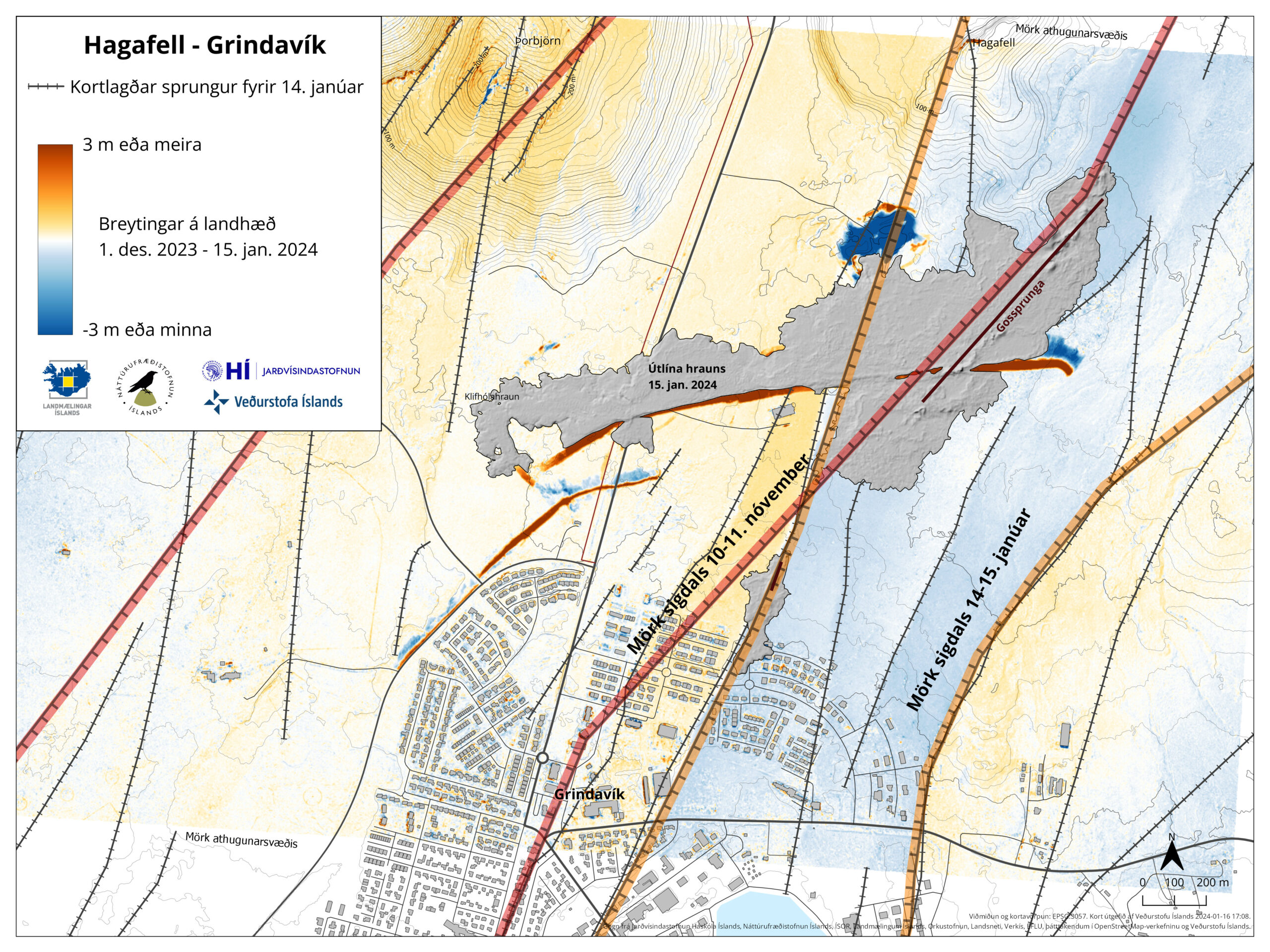
  • The lava field did reach the barriers that are protecting Grindavík town.
  • This eruption is not slowing down as quickly as earlier eruptions.
  • Harmonic tremor is mostly consistent but is lower than yesterday when the eruption started.
  • The eruption fissure seems to be around 800 meters to 1 km long.
  • There’s a ongoing risk of new fissures opening.
  • Lava flow seems to have slowed down, but that might because it might be collecting in large lava ponds that break and then the lava rushes forward at great speed.
  • Suðurstrandarvegur is at risk of getting buried by a lava flow. If that happens, the risk of the lava reaching the ocean increases, since from the road the distance is only around 500 meters.
  • There’s no signs of this eruption ending on the web cameras.
  • Craters have started forming in the active parts of the fissure.

If anything more happens I’ll post update soon as I can. Normally, an eruption from Svartsengi volcano only last around 1 day. If this eruption goes longer, then next update should be tomorrow or sooner if anything important happens.

Update on the activity in Hagafell on 17. January 2024 at 00:03 UTC

I am sorry that I am late on this. I’ve been working on my new server computer and its taken longer then expected.

The eruption has ended and it only lasted about 41 hours. The lava did burn down three houses and cause damage to road, cold water lines, hot water lines and electric lines into Grindavík town. A new rift valley formed east of the rift valley that formed on 10. November 2023. This has resulted in that Grindavík town is now an extreme danger area because of cracks in the ground that are up to 40 meters deep until a ground water level is reached. GPS data is a mess because all this been moving the crust up and down, depending if the area is either east or west of the rift valleys that have formed. It takes few days to see how fast the inflation is now in this area. The magma that erupted now did come from a sill that is located in Skipastígahrauni and Eldvörpum area to the west of the eruption site. It doesn’t seems like the sill close to Svartsengi erupted this time, since no deflation was detected there during this eruption.

The maximum amount of time until next eruption is around 30 days, with error of eight days at maximum. This might be shorter, because it seems that inflation speed is increasing. There’s lot of uncertainty in this because how the crust is now around Grindavík town.

Image showing the rift valley, along with how much it has risen or lowered in the area around Grindavík town. Along with fault lines and cracks that have formed.
Map of the rift valleys that have formed in the activity on 10. November 2023 and 14. January 2024. Copyright of this image belongs to Icelandic Met Office.

The eruptions are moving south along this area and that’s bad news, because that places the next eruption in middle of Grindavík town, once it happens in around 30 days. As is, the town of Grindavík can’t be lived in because of dangers from the faults and cracks in the ground. There has also been a major damage to infrastructure inside Grindavík already and added to the already damaged houses, roads and more.

Update on the eruption at Hagafell on 15. January 2024 at 01:14 UTC

This is a short update about ongoing eruption that can change without warning and information here can go out of date quickly.

  • Eruption started close to Hagafell mountain at 07:58 UTC on 14. January 2024. Two fissures opened up.
  • The largest fissure was at its maximum length around 900 meters. The second smaller fissure is around 100 to 200 meters long.
  • The second fissure is almost inside Grindavík town and has lava flowing into the town.
  • Lava flow has destroyed two to three houses at the writing of this article.
  • In the last few hours, the harmonic tremor has dropped. This suggest that the strength of the eruption is getting lower.
  • There’s no power, cold water or hot water in Grindavík town. Lava has destroyed the cold water, hot water and power lines that go into Grindavík town. Repairs are going to take months if Grindavík town is found save to live in after few months.
  • New fissures and displacement happened during the dyke intrusion phase of this eruption. Some areas of Grindavík town moved up to two meters in either direction according to Icelandic Met Office. At this time, accurate measurements have not been done because how unsafe the area is.
  • The eruption is happening alongside the rift valley and not in it. I am not sure why that is.

This is all I have for now. Next update should be on 16. January unless something major happens in this eruption.

Rúv has web cameras on their YouTube channel and same does mbl.is and Vísir news website.

Eruption started close to Hagafell mountain (Update for Grindavík on 18. December 2023 at 23:17 UTC)

This is a short update. Information here is going to get outdated quickly.

An earthquake swarm started at 21:05 UTC in the dyke area that formed on 10. November 2023. This earthquake swarm is ongoing and seems to be connected to when the eruption fissure expands south towards Grindavík town. The eruption started at 22:17 UTC. There’s a lot of dangerous gas pollution from this eruption. Do not get close to this eruption. This is not a small tourist friendly eruption.

A lot of red dots showing the earthquake activity in the dyke and Svartsengi just before the eruption.
The earthquake activity in the dyke. Copyright of this image belongs to Icelandic Met Office.

I’ll post new article when I know more in next few hours.

Update on Grindavík 24. November 2023

This is a short update on the situation in Grindavík and nearby area on 24. November 2023. This article is written at 18:47 UTC.
Information in this article can go outdated without warning and quickly if something happens.

This activity has slowed down for now. This means I am going to be posting update less here, unless something changes and that can happen without warning.

Daily update

  • There is movements on cracks and new holes and cracks are opening up or appearing as the ground collapses and exposes the fissure.
  • Earthquake activity has reached a low point. This might be just for a short period of time.
  • The inflation in Svartsengi is today around 140 to 160mm from 10. November 2023. The inflation each day is around 30 to 40mm.
  • The area that is inflating in Svartsengi is larger now compared to the area that inflated before 10. November 2023. This has created a uncertainty in the GPS data as I understand the situation. The rift valley is also creating issues in the GPS data as parts of him continue to sink and are going to continue to sink and lower nearby area with it. How much that is difficult to know.
  • The event that happened on 10. November 2023 was the quickest event to happen in recorded history of Icelandic Met Office. According to their report and the news.

It is my view that the current low is just going to last for few more days, at most few weeks because of the ongoing inflation in Svartsengi. It is my view that it is going to take around 30 days until next dyke activity happens, that is around 10. December when that might happen. But the situation is changing quickly and impossible to know for sure how it develops in next few days to weeks.

If anything happens. I’ll post update soon as I can do so.

Update on Grindavík on 19. November 2023

This is a short update on the activity in Grindavík on 19. November 2023. Information here might go out of date without warning. This article is written at 22:28 UTC.

Krýsuvík earthquake

This morning an earthquake with magnitude of Mw3,7 took place in Krýsuvík-Trölladyngja volcano. This earthquake was felt in Reykjavík area. This earthquake happens because of all the displacement that is now happening next to Grindavík town.

Green star west of Kleifarvatn lake. The dyke appears as a red line with a lot of smaller earthquakes.
The earthquake activity in Krýsuvík-Trölladynga volcano. Copyright of this image belongs to Icelandic Met Office.

Daily update

This is also an update for 18. November 2023. I was trying to get a little time off from writing.

  • Little has changed in last two days. Parts of Grindavík town continue to sink or rise depending on location. Most measured movements is around 25 cm last I did see. If that is correct today I am not sure.
  • Inflation in Svartsengi is around 130mm since Friday 10. November 2023 according to GPS measurements and satellite measurements.
  • Inflow of magma into Svartsengi is estimated to be around 50m3/sec when this article is written according to the news. Inflow of magma into the dyke was 75m3/sec or more few days ago. That has possibly changed to a lower number in last few days.
  • Earthquake activity remains about the same in the dyke. Around 800 to 2000 earthquakes a day along the 15 km long dyke.
Image that shows inflation in Svartsengi area on Reykjanes peninsula. This is a red area that has been lifting up 30mm/day. The image shows also colour blue and green. With blue showing area lowering and green and yellow area uplifting.
Inflation on the Reykjanes peninsula. Copyright of this image belongs to Icelandic Met Office.

It is impossible to know when this area is going to erupt. It can take up to three to four weeks to happen. It might be a shorter time period, it is impossible to know what happens when it comes to volcanoes and dyke activity.

If anything happens. I’ll post an update quickly as I can.

Update on Grindavík 17. November 2023

This is a short update on the situation in Grindavík on 17. November 2023. Information here can go outdated quickly and without warning.

Daily updates

  • Grindavík town continues to sink as the rift valley continues to move. The speed of sinking has slowed a little according to the news today.
  • Earthquake activity has slowed down in last few hours (this is written around 22:51 UTC). What that means is unclear.
  • Some houses in Grindavík town have been completely destroyed. Iceland has a natural disaster fund for this type of situation and that is going to cover the owners loss according to the news.

General update

It took me a week. But it seems that this dyke intrusion under Grindavík town is because of the magma sill (dyke) under Svartsengi. That area has inflated around 110mm in a week. That is a inflation of 15mm/day based on my best calculations. That is a lot of inflation, since before 10. November the inflow of magma into Svartsengi was at most 8m3/sec according to measurements of Icelandic Met Office.

The sill in Svartsengi created a lateral dyke in Sundhnúkar and nearby areas. When the pressure in the sill is high enough again it is going to push the magma into the dyke at Sundhnúkar again with the same force as it did before. How long that takes I don’t know. Last time this was from 25. October to 10. November. That’s seventeen days, but there was a lot of deeper sills in Svartsengi and its impossible to know much, if anything flowed form them into the dyke. This is my personal view, it might be wrong. But this is what I am reading from the data.

Risk of the eruption remains high because there’s a ongoing inflation at Svartsengi. When a eruption starts is impossible to know.

If anything happens. I’ll post update soon as I can.

Update on Grindavík on 16. November 2023

This is a short update on what is happening in Grindavík on 16. November 2023. Information here can go outdated quickly and without warning.

The situation is mostly the same as yesterday (15. November 2023), but few things have happened and that is enough for me to publish this article.

  • Sulfur dioxide has been detected in a drilling hole in Svartsengi. This drilling hole is such that it end point is close to Hagafell mountain  east to Svartsengi power plant. I think this might be a cold water hole. It has a depth of 2,5 km. This means that magma is at or close to that depth. Ground water in this area doesn’t go deeper than 1,9 to 3 km I think (I am not sure on how the fresh water ground level works in this area).
  • Eruption is expected from hours to day based on most recent measurements from Icelandic Met Office.
  • Grindavík town continues to sink according to news today (16. November 2023). Difference between days can be as much as 25 cm.
  • Mbl.is (Morgunblaðið) has a video of the damage done by this sinking on their website here. Its in Icelandic.

The situation for now is quiet, but that might only last for few hours to days longer before an eruption starts. Since earthquake activity strongly suggests that magma is looking for a way to the surface. While some magma is at shallow depth of 400 to 500 meters. There’s not enough of it to start an eruption. That can change without any warning at any time in this situation.

I’ll write updates if anything more happens here as quickly as I can.

Update on Grindavík 15. November 2023

This is a short update on what is happening in Grindavík on 15. November 2023. Information here might go outdated quickly.

In general, not much has changed since yesterday (14. November 2023).

  • There’s no change in earthquake activity. Strong wind in the Reykjanes peninsula might be masking some of the smaller earthquakes.
  • Part of the harbour area has started to sink according to news. I am not sure how much, but I think it might be considerable sink.
  • Speed of the sink in some areas of areas inside Grindavík has increased from 7 cm for each 24 hours to 12 cm for each 24 hours since yesterday. Some areas inside Grindavík have lowered as much as 2 meters or more.
  • Inflow of magma into the dyke continues to be at 75 m3/second according to news reports today. This is a lot of magma inflow into the dyke. The eruption in Holuhraun in 2014 and 2015 had an flow of 90 m3/sec when it was the most.
  • It is reported on mbl.is that it is now considered that magma might be flowing directly from the main magma chamber at 20 km to 40 km depth under this location in Reykjanes peninsula. That news is in Icelandic here.
  • Parts of Grindavík town has lost power, hot and cold water because of sinking of the ground and movements. Emergency repair is going to be attempted tomorrow if it is safe.
  • Eruption might happen at Sundhnúkar and Hagafell, where the highest flow of magma is happening according to Icelandic Met Office and the news.
  • Eruption at many craters at the same time is what is going happen here. Based on what I am seeing. That means more lava covering larger area quicker than the small eruptions in Geldingadalir, Meradalir and at Litli-Hrútur. Where it was just one crater and a small eruption.
  • Something is holding back the magma from reaching the surface. What that is unclear. But magma is at shallow 500 meters or less according to measurements done by Icelandic Met Office. This shallow depth means that magma can start erupting without much warning or notice in the dyke.

There is a chance that parts of Grindavík town might sink under the ocean because of the ground sinking. When eruption starts, what goes under lava depends on where the eruption is going to start and where the lava is going to flow. Both are random events that is impossible to know anything about.

If anything happens. I’ll post update soon as I can. If anything happens tomorrow I’ll write about it. Otherwise I plan on publishing next article on Friday 17. November 2023. Since changes at the moment are not that big changes between days currently.