Earthquake with magnitude Mw4,2 in Reykjanes volcano

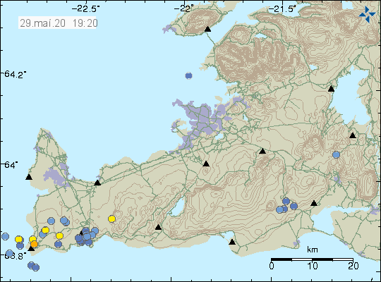
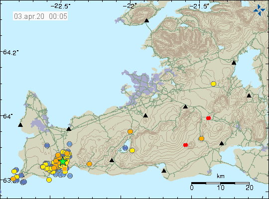
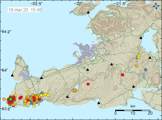
Today (18-March 2020) at 10:32 UTC an earthquake with magnitude of Mw4,2 took place in Reykjanes volcano. This earthquake started a swarm of earthquake that is ongoing at the writing of this article.


The earthquake activity in Reykjanes volcano. Copyright of this image belongs to Icelandic Met Office.

Earthquake activity is increasing again in this area of Reykjanes peninsula as inflation has resumed but at lower rate then before. That might change as the time goes on. I was unable to record this earthquakes because I am having a major problems with my earthquake computers and Microsoft has disabled activation of Windows XP and Windows Vista operating systems so I can’t use them. I am working on a solution but it going to take a little time to implement properly.

Donations

Please remember to support my work with donations. At the writing of this article I am completely broke and there are still few days left in March until April starts. Thanks for the support. 🙂

Earthquake with magnitude Mw5,2 in Þorbjörn mountain (Fagradalsfjall mountain)

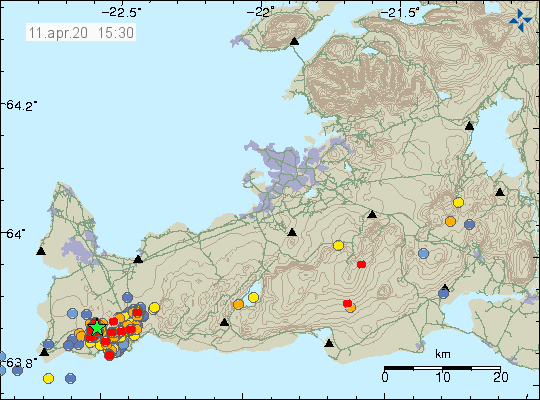
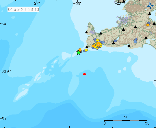
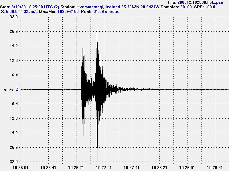
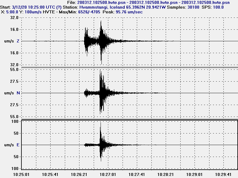
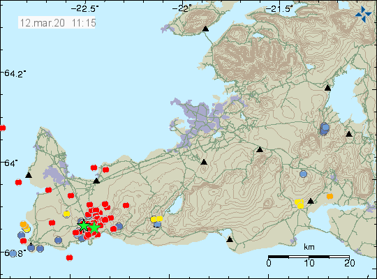
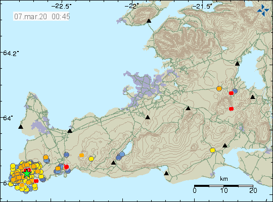
Today (12. March 2020) at 10:25 an earthquake with the magnitude of Mw5,2 took place in Fagradallsfjall mountain east of Grindavík town (Reykjanes volcano). This earthquake was felt over a wide area. This earthquake appears to be directly connected to the inflation that has been taking place in this area.


The Mw5,2 earthquake in Fagradallsfjalli mountain. This image is free to use if sourced is mentioned.


All the directions of the Mw5,2 earthquake in Fagradallsfjall mountain. This image is free to use if sourced is mentioned.


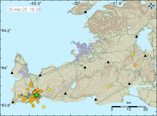
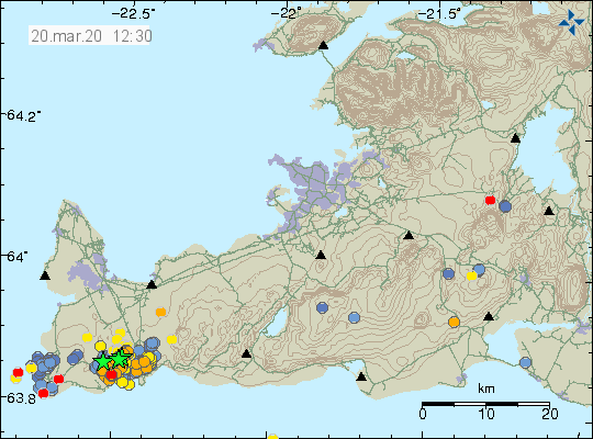
The earthquake swarm following the Mw5,2 earthquake in Fagradalsfjall mountain. Copyright of this image belongs to Icelandic Met Office.


The earthquake swarm following the Mw5,2 earthquake in Fagradalsfjall mountain. Copyright of this image belongs to Icelandic Met Office.

There is a risk of strong earthquakes in this area and it is going to be a while until it starts to quiet down again. There is at the writing of this article no signs of magma moving towards the crust. It is unclear if that is going to change but no such signs have been detected at the writing of this article.

Donations

Please remember to support my work with donations. They help me to work on this and just doing what people do in a daily life. Thanks for the support. 🙂

Ongoing earthquake activity in Reykjanes volcano (west of Grindavík town)

I am sorry for lack of updates in recent days. I have been moving and taking up from boxes and that stuff takes time and energy. I have now temporarily fixed the geophone in Hvammstangi, Iceland and that is now updating again. The geophone website can be found here.

Overview of the Reykjanes volcano activity in recent days

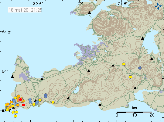
In general there has not been a lot of change in activity in Reykjanes volcano. Earthquake activity has most stopped north-east of Gridavík town when the inflation in that area mostly stopped and a little time of deflation started and stopped at 55mm based on recent GPS measurements. Earthquake activity is ongoing. There seems to be a pattern of larger earthquakes happening in the western part of the activity in similar pattern as was the case in the eastern part of the active area (Grindavík town). Largest earthquakes on Wednesday had a magnitude of Mw3,4. There is a risk of stronger earthquakes in this area.


The earthquake activity on Reykjanes volcano as of the writing of this article. Copyright of this image belongs to Icelandic Met Office.

This information might go outdated quickly if something happens in this area. Earthquake activity might be increasing again with Grindavík town but that is unclear at the writing of this article.

Donations

Please remember to support my work with donations. This is a lot of work behind each article even if that work is mostly invisible to the reader. Thanks for the support. 🙂

Increase in dangerous volcano gases detected in caves on Reykjanes volcano

It was reported in the news today that dangerous levels of volcanic gases have been detected in caves on the Reykjanes volcano. This change suggests that magma might already be close to the surface and at less than 1 km depth. Bad weather has been masking detection of smaller earthquakes in recent hours. There has not been any change in earthquake activity and inflation remains at around 60mm and has stayed there for several days.

Icelandic news

Stay out of Reykjanes caves, people warned (Rúv.is)

Increased earthquake activity in Reykjanes volcano

Today (17. February 2020) there has been a increased earthquake activity in the volcano called Reykjanes that is west of Þorbjörn mountain close to Grindavík town. Most of this earthquake activity is small with largest earthquakes having magnitude of Mw2,8. Over 160 earthquakes have happened today. Earthquake activity is ongoing so this numbers are going to change quickly.


The earthquake activity today. Reykjanes volcano is located to the far west on this image. Copyright of this image belongs to Icelandic Met Office.

Inflation continues in this area without a change and has now reached more than 60mm close to Þorbjörn mountain area. I don’t know for sure how much inflation has now taken place in this area.

Pictures of the area with the earthquakes

Today (17. February 2020) I did go to this active area to take few pictures. I didn’t get many pictures because the weather was cold and windy. All pictures are taken by me.


The Reykjanes and the Atlantic ocean. Copyright Jón Frímann Jónsson


The rock cliff of the coastline. Copyright Jón Frímann Jónsson


Eldey island at a distance. Copyright Jón Frímann Jónsson


Gunnuhver hot spring. It makes steam. Copyright Jón Frímann Jónsson

More pictures and a video can be found on my Instagram here.

Donations

Please remember to support my work. The second half of February is going to be really broke for me because of moving back to Iceland and other low income related problems. Just donate if you can do so. Thanks for the support. 🙂

Earthquake activity starts in Reykjanes volcano (west of Grindavík town)

Yesterday (14. February 2020) an earthquake with a magnitude of Mw3,1 took place west of Grindavík town. This is just one of many earthquakes this is area as earthquake activity is now continuous and shows no sign of stopping. There has also been increase in earthquake activity in the volcano named Reykjanes (far west of Grindavík town). Þorbjörn mountain is on a top of a different volcano. It seems that both volcanoes in this area are getting active and that is not a good thing.


Earthquake activity in this area. Notice all earthquakes have the direction south-west to north-east. Copyright of this image belongs to Icelandic Met Office.

This situation is getting more complicated and the rate of inflation has slowed a little in recent days while there has been increase in earthquake activity at the same time. The increase in activity in the most west volcano (Reykjanes volcano) makes the situation more dangerous as an eruption the western volcano are going to happen mostly out in the ocean and that is going to result in a volcano ash cloud for a longer or short time period.

What has now started is going to take months since it did not go the quick route with this inflation and magma activity.

Donations

Please remember to support my work if you can with donations. Thanks for the support. 🙂

Earthquake activity continues in Þorbjörn area

Today (27-January-2020) at 18:53 UTC an earthquake with the magnitude of Mw3,1 took place just north of the town of Grindavík. This earthquake activity is in a volcano inside the volcano system of Reykjanes in its fissure swarm.


The earthquake activity north of Grindavík town and north of Þorbjörn mountain. Copyright of this image belongs to Icelandic Met Office.

More earthquake activity can be expected in this area for next few days to months. Current inflation is around 4mm/day and shows no signs of slowing down according the news and GPS measurements.

Donations

Please remember to support my work with donations. Thanks for the support. 🙂

The volcano Reykjanes (Þorbjörn) information and history

The current inflation that is now happening on the Reykjanes peninsula below the tuff mountain called Þorbjörn is in a volcano system called Reykjanes in the Global Volcanism Program. Last eruption is registered having taken place in Mars 1831 at Eldeyjarboði but given the location and distance on the Reykjanes ridge that area possibly is part of a different volcano system and is not connected to the Reykjanes volcano system that now has become active. Part of this volcano is below sea level. Maps of this area can be found here and here (image). Last eruption in this system was maybe in the year 1583. There is a possibility that the eruption in the year 1583 belongs to a different volcano system that is completely under the ocean. Last confirmed eruption in this system was in the year 1240 (780 years). More information on the volcano can also be found here.

The volcano that is now active doesn’t have any special name so for clarity I am just going to call it Þorbjörn. This volcano is rather large and erupts in the form of fissure vents. Þorbjörn is inside a fissure zone of the volcano called Reykjanes and that volcano might be the main volcano in this system and it can happen that both volcanoes can erupt at the same time. I don’t know if that is going to happen this time around but there has been a earthquake activity in the main volcano called Reykjanes and part of it is below ocean and eruption that would result in ash cloud with limited distribution. This earthquake activity suggests that both volcanoes are now getting active. The volcano called Reykjanes is less dangerous because its out in the ocean and not close to any populated area. Þorbjörn is close to populated area and important infrastructure on the Reykjanes peninsula.

I have written about this area earthquake activity in last few weeks here (28-July-2017), here (15-December-2019), here (17-December-2019), here (19-December-2019), here (20-December-2019), here (22-January-2020). I do think this is all of the earthquake activity in this area since July 2017 until January 2020.


Current activity in Þorbjörn and nearby area. Copyright of this image belongs to Icelandic Met Office.

I am going to continue to monitor this situation and continue to update as best I can. Since I am currently moving back to Iceland delays may happen in the days when I move (middle of February) back to Iceland.

Donations

Please remember to support my work with donations. Thanks for the support. 🙂

Update four on earthquake activity in Askja volcano

Yesterday (13-November-2019) has been a little quieter in the earthquake swarm in Askja volcano. Largest earthquake in the last 24 hours had a magnitude of Mw3,1. Over the last 48 hours around 500 earthquakes have happened in Askja volcano. There was a peak in activity after the magntidue Mw3,1 earthquake but it slowed down soon after that. Depth of this earthquake swarm has changed slightly, deepest points are now at 7 to 8 km and that might be a problem since magma is possibly at 10 to 15 km depth in this location. If this is a magma that can erupt I don’t know, if there is magma at this location it might also be a magma that’s too cold to erupt.


The earthquake activity in Askja volcano. Copyright of this image belongs to Icelandic Met Office.

The earthquakes continue to be rift-zone earthquakes along fault lines and there is as of the writing of this article no signs of magma movement in Askja volcano as a result of this earthquake swarm. This earthquake swarm has been going on for a week from today (14-November-2019). It is a question if this earthquake swarm is over or if this is just a quiet time in this earthquake swarm activity. It is known in Askja volcano eruption history that eruption in Askja volcano and nearby fissure swarms start with long period of earthquake activity that continues to grow over time. This can be read in this studies of earlier eruptions, study 1961 eruption, study 1875 eruption. Current situation continues to keep monitoring what is going on.

Science article on earthquake activity in Askja (added link)

Donations

Please remember to support my work with donations. They help me to keep this website running. Thanks for the support. 🙂

Update three on earthquake activity in Askja volcano

This is a short update on the earthquake activity in Askja volcano.

Earthquake activity has now moved to a new phase in Askja volcano. This appears to be a rifting event taking place in Askja volcano. They do often result in a fissure eruption of lava and sometimes short lived volcano ash event. That might not happen and as of writing of this article no magma movement has been seen on nearby SIL stations. That might change without warning at any time.


Earthquake activity in Askja volcano as of 23:25 UTC on 12-November-2019. Copyright of this image belongs to Icelandic Met Office.


Density of the earthquake swarm has increased from earlier as is clear here. Copyright of this image belongs to Icelandic Met Office.

It is not possible to know what happens next in this earthquake activity in Askja volcano. The only thing that can be done is to wait and see what happens.

Donations

Please remember to support my work. It helps me running this website and buying food and such things that are needed in the daily life. Thanks for the support. 🙂