
Eruption has started close to Litli-Hrútur on Reykjanes peninsula. I’ll post more updates when I have more information.
Strong earthquake 1,4 km east of Keilir mountain
Today (9. July 2023) at 22:22 UTC an earthquake with magnitude of Mw5,2 happened 1,4 km east of Keilir mountain. This earthquake did shake Keilir mountain and resulting a small dust cloud. This earthquake is connected to inflation that is happening just south of Keilir mountain, rather than being connected directly to magma movements in this area.
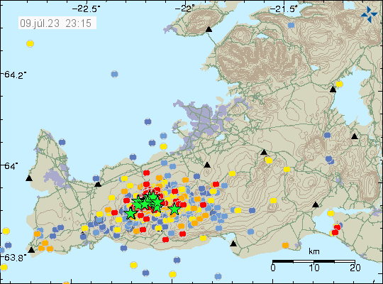
There’s a risk of more strong earthquakes like this in this area until an eruption starts.
Update on activity in Fagradalsfjall – Keilir mountains on 9th July 2023 at 16:11 UTC
This is a short update, because there’s little to report.
- Three earthquakes with magnitude above Mw4,0 took place north east of Keilir mountain in the last 24 hours.
- Earthquake activity is increasing north-east and north of Keilir mountain. Why is unclear, it is a possibility that magma is creating a path for it self that way.
- The magma seems stuck in the crust and there doesn’t seems to have stopped the inflow of magma from the deep mantle. This is going to result in increased pressure in the dyke until an eruption happens.
- Risk of strong earthquakes is high and might get higher until an eruption starts.
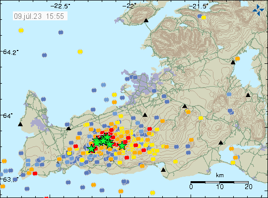
Since the start of this activity, around 12000 earthquakes have been recorded by Icelandic Met Office according to the news. Strongest earthquake at the writing of this article is at magnitude Mw4,8.
Stress related earthquake in Krýsuvík-Trölladyngja volcano system
Today (8. July 2023) at 17:57 UTC an earthquake with magnitude of Mw4,5 took place in Krýsuvík-Trölladyngja volcano system. This is a stress realted earthquake because of the inflation between Keilir and Fagradalsfjall mountain.
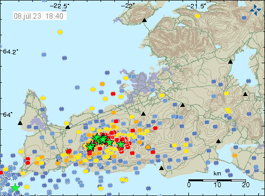
More of this earthquakes are going to happen both east and west of the dyke between Keilir and Fagradalsfjall mountains. Both before an eruption and after it ends. This type of earthquakes can have magnitude above Mw5,0 and they can happen in areas that have been quiet so far.
Update on the activity in Fagradalsfjall mountain on 7th July 2023 at 14:28 UTC
This is going to be a really short article. Because an eruption might be about to start. Difficult to be sure, but there’s a chance. Eruption has not started at the writing of this article.
- Largest earthquake in the last 24 hours seems to be a magnitude Mw4,3. I no longer can keep up with all this earthquake activity.
- Inflation in area close to Keilir has reached 200mm (20cm) in less than 48 hours when this started.
- Inflow of magma is estimated to be 88m3/s and that is a lot of magma moving and moving fast.
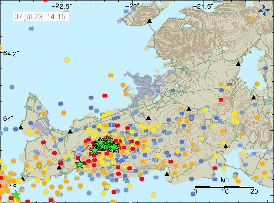
It is unclear where the eruption is going to happen. But there has been a drop in earthquake activity that strongly suggest that magma is close to finding a path to the surface. According to measurements, the magma is now less than 1 km away from the surface.
Update on Fagradalsfjall mountain activity at 16:35 UTC on 5th July 2023
This is a short update since there is a lot going on.
- Largest earthquake recorded at the writing of this article is Mw4,8 from earlier this morning.
- Larger earthquakes are growing in numbers. There is now also a warning for possible Mw6,3 earthquake on Reykjanes peninsula following this earthquake swarm and dyke intrusion into Fagradalsfjall mountain.
- The dyke intrusion is coming up just south of Keilir mountain.
- Based on what I am seeing, it is possible that current dyke intrusion into Fagradalsfjall mountain is larger than the first eruption in March 2021. If this is accurate is a wait and see situation until an eruption starts.
- It is possible to view the earthquake activity in real time here, at Raspberry Shake website.
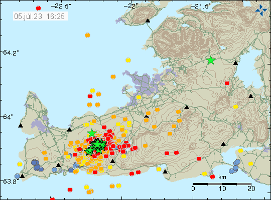
All data now suggest that an eruption is going to happen. Where it is going to start erupting is impossible to know and it is not possible to know when it is going to start erupting.
I’ll try to post update when more is known about what is going on.
Update on Fagradalsfjall activity at 11:40 on 5. July 2023
This is a short update since this situation is changing quickly.
- Largest earthquake recorded so far had a magnitude of Mw4,8 and was felt over a wide area.
- Uncertainty level has been declared for Fagradalsfjall mountain area because of this earthquake activity and the risk of an eruption.
- Current depth of the magma is now 3 to 6 km and is getting shallower by each hour.
- Over 2000 earthquakes have been recorded at the writing of this article.
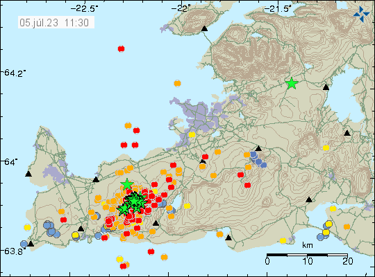
The only web camera that I know of at the moment and is showing Fagradalsfjall mountain is this one here. When the eruption starts, it should be visible in some part on this web camera. I hope that other closer web cameras are going online soon. Those where run by Rúv and mbl.is in last eruption.
Earthquake swarm in Fagradalsfjall mountain
Today (4. July 2023) there has been a earthquake swarm in Fagradalsfjall mountain. Largest earthquake had a magnitude of Mw1,6 and at the writing of this article there have not been any earthquakes with magnitude above Mw2,0. This might change without warning.
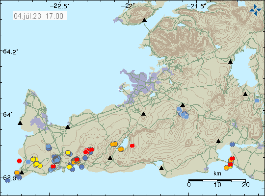
Smaller earthquakes swarms sometimes seems to happen before an eruption in Fagradalsfjall mountain. The current earthquake swarm has all signs of dyke intrusion. If that is going to result in eruption now is impossible to know.
Reykjanes peninsula might be one large volcano
It was in the news today (3. July 2023), since inflation has been detected from GPS data on Reykjanes peninsula since start of April. What was told in a interview on Bylgjan (radio channel) and later published on Vísir.is news website (link below, but the whole thing is in Icelandic) is that all of Reykjanes peninsula is inflating. What is also starting to show in the GPS data is that there might not be separate volcanoes on Reykjanes peninsula, this might also have happened in the year 2020 – 2021, before the first eruption in Fagradalsfjall mountain. All of Reykjanes peninsula might be one large volcano, extending from Hengill to Eldey or Eldeyjarboða, the south end might have uncertain location. This changes everything as that means that it can erupt at any location on the Reykjanes peninsula without warning and the whole area is now in an eruption cycle.
The current period of inflation started in April and is now at 2,5cm (25mm) and is centered at the last eruption location in Fagradalsfjall mountain. That means the most likely location of next eruption is going to be Fagradalsfjall mountain. This inflation is also going to trigger large earthquakes on Reykjanes peninsula in next few weeks to months until an eruption starts. Along with the normal amount of small earthquakes that have been happening since April on the whole of Reykjanes peninsula.
I don’t know when or how long it is going to take to change the official definition of the Reykjanes peninsula. Because this is going to require more research and data collection for the scientists in Iceland. This also means a lot of new science papers have to be published and peer-reviewed.
Icelandic news
Fólk á suðvesturhorninu má búa sig undir reglulega jarðskjálfta (Vísir.is)
Magma detected deep under Reykjanes peninsula
According to a news on Rúv News there has been detection of magma at considerable depth on Reykjanes peninsula. This magma is actively trying to reach the surface, but has not been successful for now. This has resulted in a lot of dyke intrusions on the Reykjanes peninsula in recent months. Earthquake activity seems to follow each inflation period on the Reykjanes peninsula according to the news.
The magma in the deep crust and in the mantle is going to increase in volume until it can break up the surface. How long that is going to take is something I don’t know. Next eruption cycle is going to start with a large earthquake, just like the last one. Based on all current data that I have.
Rúv news in Icelandic