Long eruption is now expected in Fagradalsfjall in Geldingadalir valley (soon a former valley) based on lava chemical details

This is not a update on the eruption. There has not been any major change in the eruption at the writing of this article.

University of Iceland has released a report that can be read here (pdf) showing that the magma that is now erupting comes from the depth of 17 to 20 km. Crust at this location on the Reykjanes peninsula is around 17 km deep. A 3D map can be found here of the eruption. I think it is going to updated regularly by ÍSOR. The lava that is now erupting is part of Tholeiitic magma (Wikipedia). The lava is 1180C when it erupts from the ground.

What seems to be now happening is that a shield volcano is forming. It is a question if this is going to result in a formation of new magma chambers along the dyke where it formed. There is continued risk that new vents and fissures eruptions opens in this change can happen without warning. Based on earthquake activity it seems that the dyke continues to be active rather than having turned into rock by cooling.

The eruption is also high in the following gases, CO (Carbon monoxide), CO2 (Carbon dioxide), SO2 (Sulfur dioxide) and other dangerous gases.

It is now estimated that the Geldingadalir valley is going to overflow in 8 to 18 days and currently a lava pond is forming at this location. Once that happens the lava is going to flow into nearby valley (I can’t find the name of it). One of the valley the lava is in the end going to flow into Nátthagi valley if the eruption lasts long enough.

Short analyse of events of Katla volcano 28th and 29th of July-2017

Icelandic Met Office released interesting graphs of the activity in Katla volcano during the 28th and 29th of July-2017. It gives clues to what might happen just before an eruption in Katla volcano.

Harmonic tremor pulses

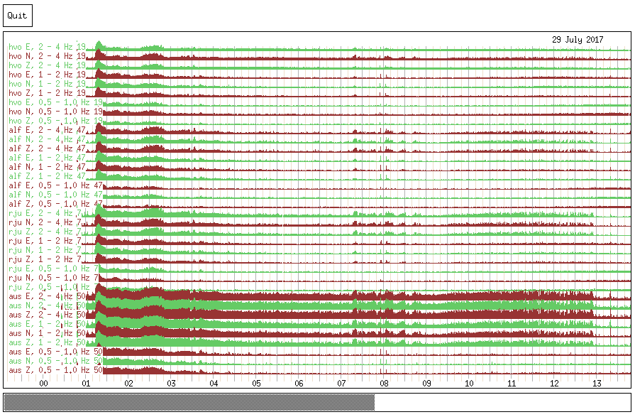
On the 28th of July small and short harmonic tremor pulses appeared on SIL stations around Katla volcano. When 29th of July did come the harmonic tremor intensified considerably from what it had been the day before. The harmonic tremor pluses on 28th of July is close to impossible to see on the harmonic tremor plot on Icelandic Met Office website.


Harmonic tremor pluses as they appear on Icelandic Met Office tremor software on 28th of July-2017. Each frequency has it’s own line. Time is horizontal and intensity is vertical. Copyright of this image belongs to Icelandic Met Office.


The harmonic tremor as it is by 29th of July-2017. After midnight the activity intensifies considerably from earlier levels. Copyright of this image belongs to Icelandic Met Office.

This data suggests that before an eruption happens some type of boiling or increase in hydrothermal vents takes place in Katla volcano. This is also connected to the glacier flood that followed into Múlakvísl glacier river.

Glacier flood and harmonic tremor


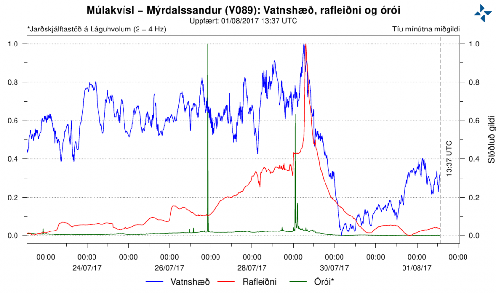
Blue: Water level. Red: Conductivity. Green: Tremor activity. Values are at 10 minute central value. This data is from the SIL station at Lágu Hvolar. Copyright of this image belongs to Icelandic Met Office.

There seems to be some connection between the harmonic tremor change and the changes in the glacier flood. That suggest in my view that a minor eruption took place in Katla volcano during 28th and 29th of July. How long the eruption did last is a good question. Harmonic tremor data suggests it was only for few hours before it ended. New cracks have been seen around Cauldron 10 in Mýrdalsjökull glacier according to reports. Locations of cauldrons in Mýrdalsjökull glacier can be found here on University of Iceland Earth Science map.

That would be the end of the story in most normal years. Minor eruption and then nothing more. That does not seem to be the case this time around. Small pulses of harmonic tremor have been taking place during the week (Week 31) and that seems to be ongoing process. Most of the tremor pulses are hard to see on the SIL stations and most don’t even appear on more then one or two SIL stations. At the moment Katla volcano is quiet and that might go on for a considerable amount of time due to this minor eruption (my view) and connected glacier flood.

Donations

Please remember to support my work. Currently I am really broke and this month is going to be difficult like earlier months of the year 2017. Thanks for the support. 🙂
This financial situation is slowly getting better and is going to be fully or mostly resolved by July-2018 I hope.

Images of earthquakes in Katla volcano and GPS data

Here are few images of the last earthquakes in the large earthquake swarm that took place in Katla volcano 28 – 30-September-2016. The alert status for Katla volcano has been downgraded from Yellow to Green.

Earthquake information from Heklubyggð geophone

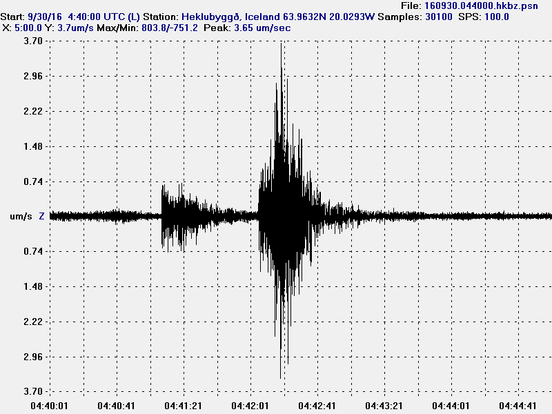
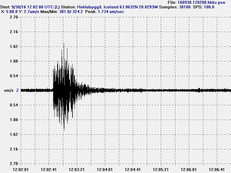
I was only able to record few earthquakes from the swarm in Katla volcano. Along with the largest earthquakes that happened. Most of the earthquakes where hybrid earthquakes or Volcano tectonic earthquakes, few low frequency earthquakes took place, but I recorded them really poorly due to weather and strong wind at the time in south Iceland. More information about earthquake volcano types can be found here (USGS) and here (alaska.edu). There are no P and S wave markers in this images. I didn’t have the time to process this earthquakes properly yet.

160930-044000-hkbz-psn
The first earthquake appears to be hybrid earthquake. The second earthquake appears to be a volcano tectonic earthquake. This image is under Creative Commons Licence, please see CC Licence page for more details.

160930-120200-hkbz-psn
This appears to be a volcano tectonic earthquake. This image is under Creative Commons Licence, please see CC Licence page for more details.

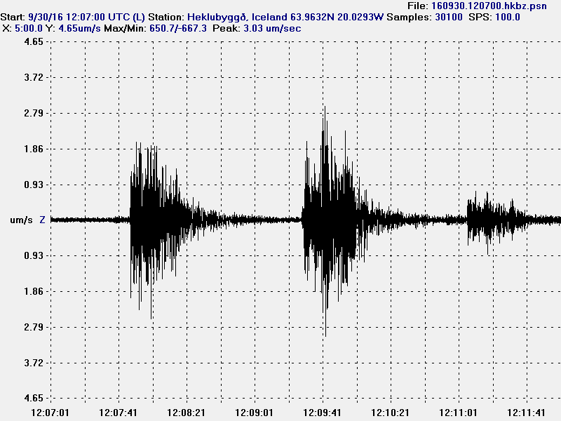
160930-120700-hkbz-psn
The first earthquake appears to be volcano tectonic earthquake, the second earthquake appears to be two earthquakes happening at once. Making analyse of what type this is difficult. The last earthquake appears to be a hybrid earthquake. This image is under Creative Commons Licence, please see CC Licence page for more details.

The largest earthquakes all appear to be volcano tectonic earthquakes. Other earthquakes where difficult to record due to high wind noise at that time.

GPS information

I finally found the GPS information website for Katla volcano. There isn’t much change on most of GPS station around and on Katla volcano. The most change is happening in Austmannsbunga (AUST) inside the caldera. Other GPS stations do now show this change, suggesting that it might be highly localised change not appearing on other GPS station for now. This doesn’t look like a error or a fault in the measurements. The GPS website for Katla volcano can be found here.

What is going on in Bárðarbunga volcano – basic analyse

This the first analyse article that I’m going to write. It is going to a short one and not written over few days, as is the plan to have them in the future. The reason for this is that this information might get outdated quickly as things change in Bárðarbunga volcano. This is going to be broken down into few parts for clarity (if possible).

Current activity in Bárðarbunga volcano

Bárðarbunga volcano is preparing for a new eruption and has been doing so since March-2015, few days after the eruption ended in Holuhraun. Where this eruption is going to take place is impossible to know fore sure, but there are clues to what might happen (it doesn’t mean it is going to). Current earthquake activity pattern suggests that the next eruption is going to take place directly south of Bárðarbunga volcano, slightly south of the Holuhraun dyke formation. At that location there is a dyke formation that has been building up for the last few years and in recent months I’ve noticed a slight increase in activity around that dyke, it has been making branches from it self, creating small earthquakes swarms in the process. I don’t know how large this dyke is, but what is clear from earthquake data is that it is deep, goes down to at least 25 km depth, maybe deeper.
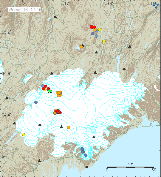
160525_1715
The cluster of orange dots is the dyke showing it self earlier today. Copyright of this image belongs to Iceland Met Office.

Since the activity started in Bárðarbunga volcano, this dyke has changed and appears to have started growing at some point (I don’t know when). Current size suggest that it is already large and contains large amount of magma. Amount is hard to estimate, but pure guess (short of educated) suggests that the amount of magma in this one dyke is already high and more might be at depth (25+ km depth). This one dyke has existed, or formed around 2005 – 2008 at earliest, it might have formed a good while ago, but this are the years I first saw it in the earthquake data. It is all over thick glacier (200 meters or more), so any eruption at that location would result in a glacier flood.

Eruptions risk at the moment

Currently Bárðarbunga volcano is in what I call “Active phase – not erupting”, meaning the volcano is not dormant (no activity at all). The risk of an eruption at the moment is in my view around moderate, nothing suggest that it is at high levels. That however is changing with each passing day and it is my view that one day there is going to be a earthquake swarm and activity that is going to start a new eruption in Bárðarbunga volcano and there is a good chance that eruption is going to take place under the glacier.

The caldera cauldrons (on the rim)

When the earthquake activity, connected with the dyke intrusion started in August-2014 and few eruptions under the glacier, few cauldrons formed in the glacier. Over the past few months those cauldrons have been getting larger and deeper, the glacier they are melting is up to 200 meters thick in this area (far as I know). The reason for this cauldron formation is the collapse (called slow collapse) of the Bárðarbunga volcano in 2014 – 2015 eruption. This suggests that magma has found a pathway to the shallow crust (5> km), but does not have the energy to start an eruption at the moment. This magma might never erupt at all, it might only create new hydrothermal areas in Bárðarbunga volcano. Paper on the collapse of Bárðarbunga volcano caldera can be found here, I don’t know how accurate or if this has been peer-reviewed article.

Earthquake depths

When something happens in Bárðarbunga volcano, like a strong earthquake swarm with magnitude 3,0 or larger earthquake taking place it sometimes has a activity taking place several hours before it. Here is how to spot it if it happens, it does not always take place for random reasons.

bardarbunga.earthquake.23.05.2016
Small earthquake in Bárðarbunga volcano, but notice the depth of 26,8 km. Screen-shot from Iceland Met Office website.

Depth is an important factor here, this earthquake took place at 26,8 km depth, suggesting that magma created it. That is not always the case, but it appears that this time it was. Since 12 hours later a magnitude 3,4 earthquake took place, meaning the pressure inside Bárðarbunga volcano changed (as I understand how this works).
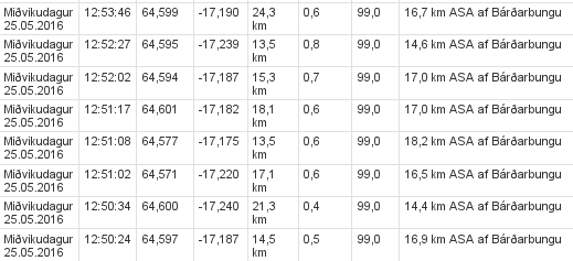
bardarbunga.earthquake.25.05.2016.b
The dyke earthquake swarm. All magnitudes are small, but depth is the interesting part. Screen-shot from Iceland Met Office website.

The dyke earthquake swarm has different pattern. As the magma pushes up the dyke from deep it creates earthquakes along the weak points in its structure, making the depth appear at random as earthquakes are formed. This also expands the dyke a little, low amount of earthquakes indicates that there is not much of a resistance in the dyke where it is expanding at the moment.

Donations

Please remember to support my work so I don’t have to worry about bills and other money connected issues so much. Thanks for the support. 🙂