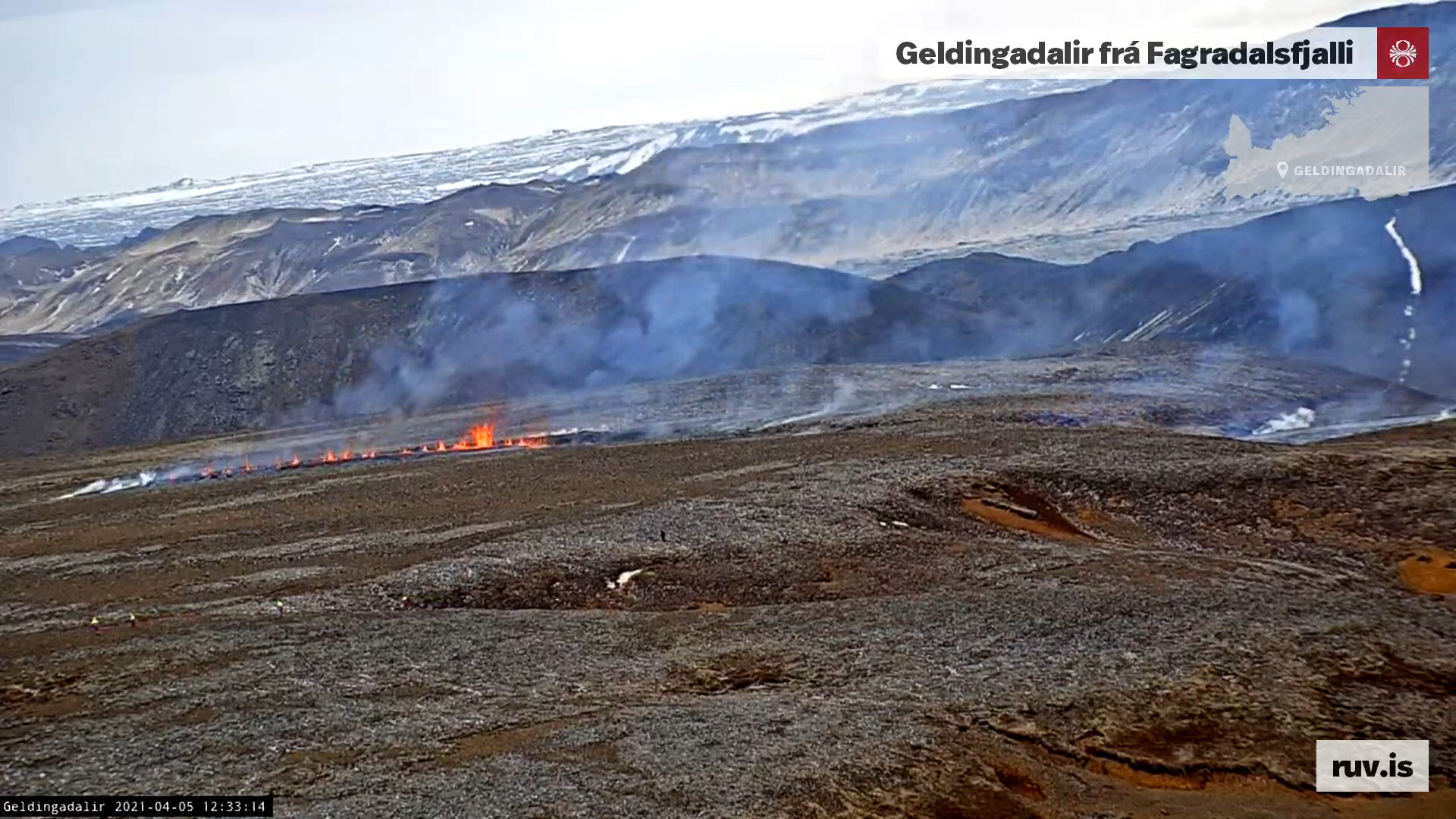
New fissure started to open up at around 11:37 UTC on 5-April-2021 when a magnitude Mw1,5 earthquake (most likely) took place in Fagradalsfjall mountain. The new fissure is expanding and but I am now estimating that the current length of the new fissure is 1,2 km based on Rúv News web camera view. The new fissure is north-east of the earlier eruption in Geldingadalir valley any.
The new fissure opening up. Copyright of this image belongs to Rúv. From Rúv web camera.
I’ll post update about this later today when I know more.
Update at 16:29 UTC
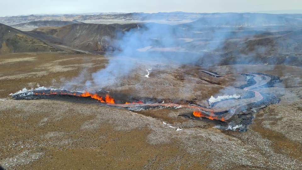
The larger fissure is around 300 meters long according to reports. Part of it seems to be under its own lava flow based on what I am seeing on new videos of the fissure. The second fissure is about 10 to 30 meters long. There is also a one single eruption vent in the area just outside of the fissure areas. The lava flow is going into Meradalir below the new fissures. It might soon go into a what seems to be a lake or a dried up lake in that valley that is a lot larger and deeper than Geldingadalir valley that is now full of lava. The eruption in the original craters continues but at lot less energy levels than before. This might only be temporary change but it is impossible to know for sure what is going to happen.
Next update is going to be again in few hours as this situation develops.
Pictures are from Department of Civil Protection and Emergency Management.
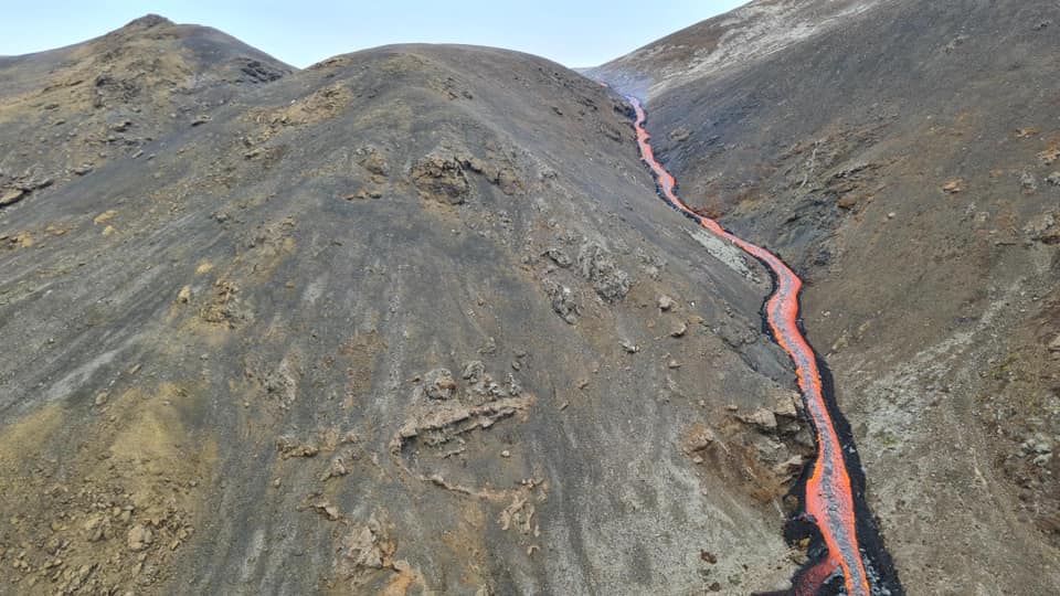
The eruption from a helicopter as seen today. Picture is from Department of Civil Protection and Emergency Management. Free to use.The lava river into Meradalir valley. Picture is from Department of Civil Protection and Emergency Management. The pictures is free to use.
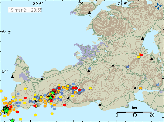
During the night 4-April-2021 at 02:04 UTC an earthquake with magnitude Mw3,0 at 5,7 km depth took place 1,5 km south-west of Keilir mountain. This earthquake was felt in Reykjavík area and outside of it. Based on the earthquake location it looks like it is located in the dyke or close to it. This is part of the Krýsuvík-Trölladyngja volcano.
Earthquake activity on Reykjanes peninsula. Copyright of this image belongs to Icelandic Met Office.
Along the magma dyke there seems to be forming focused points of earthquake activity. Currently I am seeing two location. The first location is around the eruption in Geldingadalir valley (former) and the second location that seems to be forming is just south of Keilir mountain. It has been my experience during the eruptions over the last few years that this type of earthquake activity might suggests that new location where eruptions might take place based on this earthquake activity. It is impossible to know if anything is going to happen. There is no change in GPS data since the eruption started. The GPS data can be viewed here.
This is a short update of the activity in the eruption in Geldingadalir valley (former, as the valley has now filled up with lava or close to being filled with lava). The eruption is taking place in Krýsuvík-Trölladyngja volcano system. The eruption has been stable all week. On Sunday 28-March-2021 other side of the craters that had built up collapsed into the lava stream that has formed below the erupting craters. Both craters are now about equal erupting size.
The lava that is now erupting is primitive Tholeiitic magma based on the chemical analyse from University of Iceland. That report can be found here (pdf).
Both craters are unstable and often suffer a collapse and rock slides and that often changes their look suddenly and drastically in a moment.
Icelanders continue to act like idiots in front of the web cameras that show the eruption online (I think all of them). The Rúv web camera is a large structure there that is easy to avoid (with solar panels and everything).
Lava boiling is a common occurrence that often breaks up through the newly formed crust in the new lava field. This happens without warning and often reshapes the lava field in a instance.
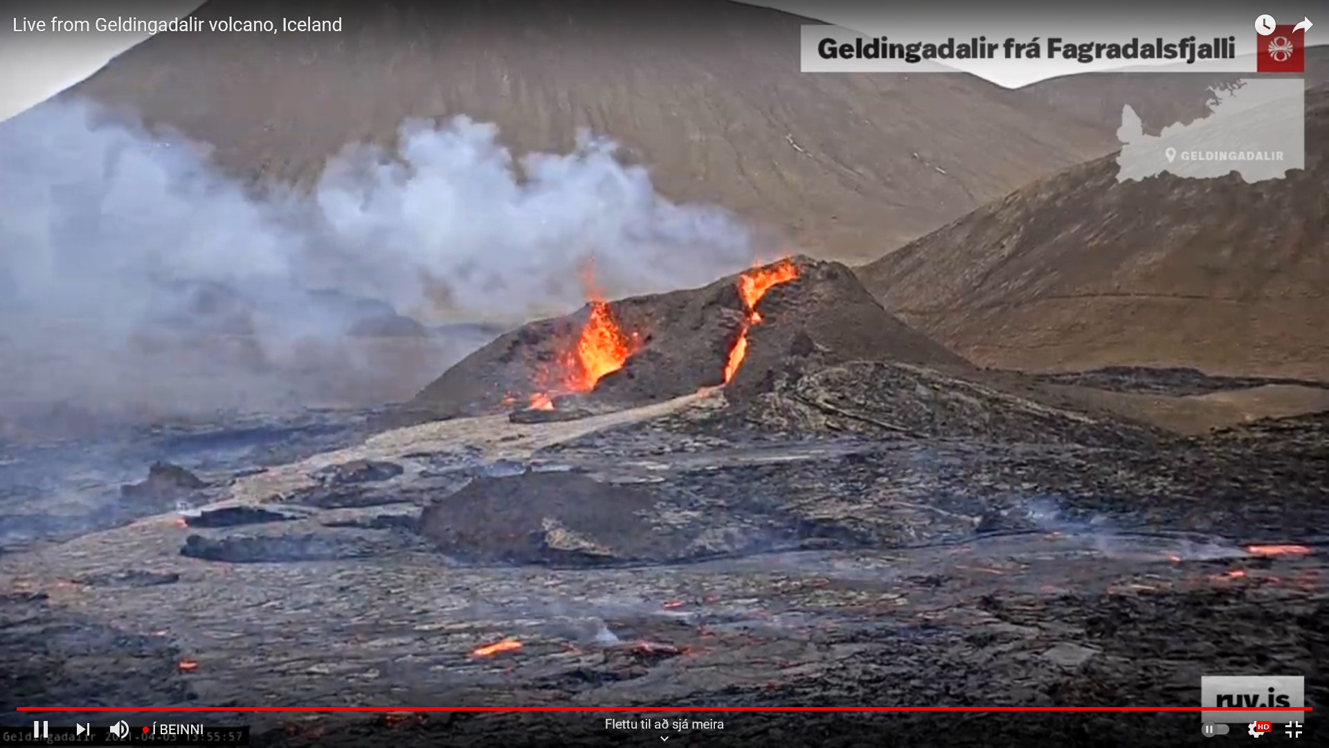
Spatter activity in the eruption craters often drops but the flow of lava seems to be stable based on the web cameras and observation reported in the news by volcano scientists according to the latest news I was able to find.
It is unclear when lava is going to start flowing out of Geldingadalir valley (former). It might start to happen this weekend or by next week.
Based on what I am observing on the web cameras at the writing of this article. A collapse might happen in the erupting crater on the right side on the screen (I don’t know what is north and south on the web camera). When that or if that happens is impossible to know, but the whole structure that I am seeing doesn’t look that stable when I write this article.
At the writing of this article a large collapse took place in the erupting crater on the left side on the camera. Resulting in block of the erupting vent and resulting in a lot of spatter activity as a result as it clears it self of the rock that fell into it.
Currently there are no signs of this eruption about to end. This eruption might go on for a long time. Next update about the eruption in Geldingadalir valley (former) should be on 9-April-2021 unless something major happens in the eruption.
Update 14:12 UTC on 3-April-2021
The eruption craters at 13:56 UTC on 3-April-2021. Copyright of this image belongs to Rúv. From Rúv YouTube stream of the eruption.
There is now in the northern crater (right side on screen?) a small lava fall. Its not big but it is few meters high. There are variations in spatter activity and the whole crater structure remains unstable. There are many collapses and changes now over one day.
Donations
Please remember to support my work with donations. It helps me keeping everything going. Thanks for the support. 🙂
Cloudflare
I have now added Cloudflare to this website. That should prevent any problem with using it when a large spike in traffic happens as was the case when the eruption in Geldingadalir valley first started.
Advertisements
I re-applied to Amazon Associate accounts and that is now active but my website has to make a sale in next 180 days to make that permanent again. This rule also applies to old accounts. If you shop from Amazon using the Amazon banners (United Kingdom, United States, Germany) gives me a little extra income.
This is not a update on the eruption. There has not been any major change in the eruption at the writing of this article.
University of Iceland has released a report that can be read here (pdf) showing that the magma that is now erupting comes from the depth of 17 to 20 km. Crust at this location on the Reykjanes peninsula is around 17 km deep. A 3D map can be found here of the eruption. I think it is going to updated regularly by ÍSOR. The lava that is now erupting is part of Tholeiitic magma (Wikipedia). The lava is 1180C when it erupts from the ground.
What seems to be now happening is that a shield volcano is forming. It is a question if this is going to result in a formation of new magma chambers along the dyke where it formed. There is continued risk that new vents and fissures eruptions opens in this change can happen without warning. Based on earthquake activity it seems that the dyke continues to be active rather than having turned into rock by cooling.
It is now estimated that the Geldingadalir valley is going to overflow in 8 to 18 days and currently a lava pond is forming at this location. Once that happens the lava is going to flow into nearby valley (I can’t find the name of it). One of the valley the lava is in the end going to flow into Nátthagi valley if the eruption lasts long enough.
This is a short article about the eruption in Geldingadalur. The volcano that is erupting continues to be Krýsuvík-Trölladyngja volcano system. This might change at later date. This article is written on 22-March-2021 at 17:30 UTC.
The eruption is now mostly just in one crater. There is some activity in two other craters but it seems to be getting smaller as the eruption goes on.
This eruption is tiny and one of the smallest eruption observed in Iceland.
There is risk of new eruption opening up once this eruption ends or starts to get close to ending.
There is a fissure in the ground on the right side of the main crater (as seen on the web camera). A lot of volcanic gas comes from that fissure but no eruption has taken place so far.
There has not been any noticeable deflation according to GPS data from today (22-March-2021).
The main crater is now estimated to be 30 meters high but it is unstable and collapses often.
The lava is estimated going to fill Geldingadalur valley in 10 to 14 days if the eruption continues this long.
Earthquake activity has almost stopped on Reykjanes peninsula after the eruption started. Once the eruption stops earthquake activity might increase again.
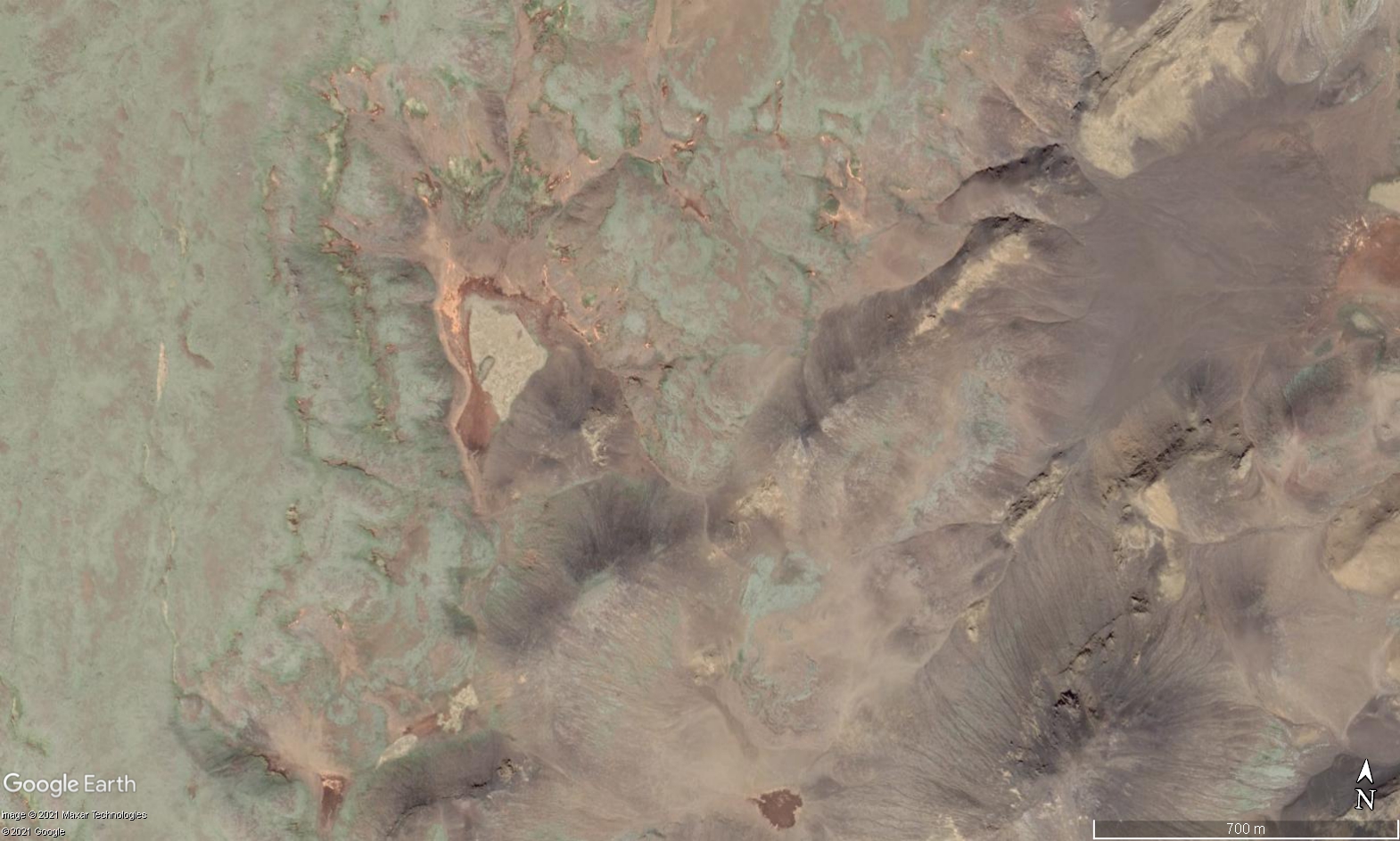
This is a image from Google Earth and shows Geldingadalur valley that is now being filled slowly with lava. Copyright of this image belongs to Google Earth/Google and other companies that Google has made this image available with its Google Earth program.
The last eruption period on Reykjanes peninsula lasted from the ~700 to the year ~1400. It can be estimated that current eruption period that has now started on Reykjanes peninsula is going to last until the year ~2400 to the year ~2600. During this time shortest time between eruptions is 1 year but the longest time between eruptions might be up to 10 years. How this going to be exactly is a big question but this estimate of mine is based on the limited historical data that I have read somewhere (I no longer remember where that was).
According to the evening news on Rúv the lava and magma that is now flowing into the valley of Geldingadalur is around 1200C and is a primitive magma of Tholeiitic magma series (Wikipedia). The source of this eruption is a magma chamber with the depths of 17 km to 20 km and the origins of the magma it self is far deeper into the hotspot below Iceland. This magma has a lot of CO and CO2 gases that are highly dangerous. There is also a lot of SO2 gas in the eruption and that is dangerous gas.
News in Icelandic about this
Since the eruption is now in stable activity I am going to limit update to if anything major happens. Next update about the eruption should be on Friday 26-March-2021. Other activity in Iceland is going to be reported as normal if anything happens.
Donation
Please remember to support my work with donations. Google Adsense remains limited on my website and I don’t know when it might get back to normal. Thanks for the support. 🙂
Article updated at 18:32 UTC. New web camera added. Article updated at 20:50 UTC. Web camera information updated. Article updated at 23:57 UTC. Information added about the eruption.
This information is going to get outdated quickly. This article covers Krýsuvík-Trölladyngja volcano. This article is written on 21-March-2021 at at 00:40 UTC.
This eruption is tiny. The amount of magma erupted is now around 0.02km3 but this number might not be fully accurate since I’ve not seen any published number about of volume of lava erupted so far.
This is unconfirmed but it is possible that an new fissure opened up under the lava field next to the hill side (seen on the web camera, this is on the left side).
The current erupting fissure is now about 200 meters long and might be getting shorter.
Earthquake activity has almost stopped at the writing of this article.
This eruption might only last 1 to 3 days before it stops.
There is no sign of deflation in the GPS data at the writing of this article.
There are no other reports about this eruption at current time. This might change without warning.
Beint vefstreymi af eldgosinu – Vogastapi (Rúv.is) – Added 22-March-2021. View from a distance. Should show a red glow from the eruption if the weather isn’t too bad. – This web camera is no longer active!
Update at 15:28 UTC – One side of the main crater collapses
Here is a video of the main crater collapse on one side and give lava a new path for short period of time. At the writing of this update that path for the lava has closed down again.
Kvikustreymið braut sér nýja leið (Rúv.is) – This is a new video of the crater collapse that took place at 14:20 today (21-March-2021).
Article updated at 15:29 UTC. New information added. Article updated at 21:21 UTC. New information added. Article updated at 03:06 UTC on 22-March-2021. Web camera added.
em>Article updated at 16:34 UTC on 22-March-2021. Web camera has been removed by Rúv – comment added to that web camera.
This is a short overview of the eruption that is now ongoing in Geldingadalur in Fagradalsfjall mountain area. This is part of Krýsuvík-Trölladyngja volcano system according to latest information. This information might change as the time and more information is collected. This article is written on 20-March-2021 at 02:58 UTC.
This is the first eruption in Krýsuvík-Trölladyngja volcano system since the year 1340.
The eruption started at 20:45 UTC according to Icelandic Met Office. The harmonic tremor from the eruption is almost invisible.
The fissure is at the writing of this article estimated about to be 1 km long with the direction south-west and north-east.
Currently the eruption is small and there is no risk of damage to any infrastructure. Next road (currently closed because of earthquake damage) that might get damaged is 2,5 km distance from the eruption site.
This eruption suggests that more eruption might start in different fissures once this eruption is over.
The valley that the lava is flowing into might get filled with lava if the eruption lasts long enough. The valley next to it is equally deep so there is no danger of this lava flow.
The eruption is in a area that is difficult to access even by a car.
The earthquake activity in the dyke. Copyright of this image belongs to Icelandic Met Office.
The eruption might only last for two to three days as it currently looks but that might change without warning since it is impossible to know for sure what is going to happen next with this eruption.
There are no good web cameras of this eruption since it is remote and started late on Friday night and the weather on Reykjanes peninsula is not good for today (20-March) or tomorrow (21-March).
Updated at 04:49 UTC. Web cameras added to this article.
Article updated at 03:49 UTC. Information added. Spell check fixes. Article updated at 04:52 UTC. Web cameras added. Article updated at 14:44 UTC. New web camera added from Rúv.
This is a short article that because the situation can change without warning and article is written on 19-March-2021 at 21:07 UTC. There have been updates to names used and now Krýsuvík-Trölladyngja name is used by Global Volcanism Program and Icelandic Met Office. Suggesting that the magma that is about to erupt has its origin in Krýsuvík volcano system eat of current centre of activity. This sometimes happens in Iceland when magma travels long distances deep underground.
Earthquake activity in Krýsuvík-Trölladyngja volcano system. Copyright of this image belongs to Icelandic Met Office.
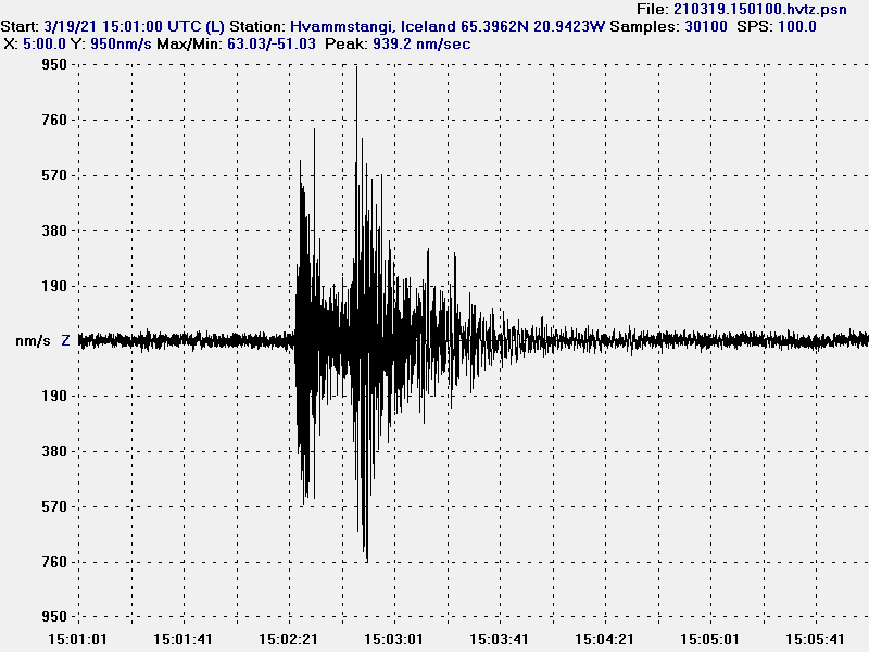
Today at 15:01 an earthquake took place with magnitude of Mw3,1. This earthquake has in my view clear signs of magma movement close to the surface as the depth of this earthquake was just 0,1 km (100 meter).
A magnitude Mw3,1 earthquake that took place today at 15:01 UTC.
This earthquake strongly suggests that magma created it at shallow depth. It has not yet resulted in an eruption but it is a question if this the final sign before an eruption happens. The current quiet time might last up to 2 months but it is impossible to know for sure.
This is a short article written on 17-March-2021 at 17:49 UTC. The situation can change without warning.
It has been less activity in in Fagradalsfjall volcano (Krýsuvík volcano). Current day to day change is not a lot at the writing of this article but it is also possible that bad weather that is now passing over Iceland is masking some of the smaller earthquakes in the dyke between Keilir mountain and Fagradalsfjall mountain. Inflation continues at what seems to be about the same rate as yesterday (16-March-2021).
Earthquake activity in Fagradalsfjall volcano located between Keilir mountain and Fagradalsfjall mountain. Copyright of this image belongs to Icelandic Met Office.
Number of strong earthquakes has dropped after the strong earthquake activity during last weekend (12 to 14 March). What also changed is that the dyke can’t move more south then it already has. It seems that it hit a impasse in the crust that it was unable to break or go around (harder crust is the most common why this happens). The current status is a waiting for the eruption to start and when that happens is impossible to know.
Since there is not a lot of change going on at the writing of this article I am going to slow down the number of updates I am posting. Next update is going to be when something happens or at the latest Monday 22-March 2021.
This is a short article because the situation is always changing. This article is written on 15-March-2021 at 21:23 UTC. This article is about Fagradalsfjall volcano but Icelandic Met Office updates go to Krýsuvík volcano so I link to that volcano also.
Between Friday and Monday the activity in Fagradalsfjall volcano was really strong. Several earthquakes with magnitude above Mw4,0 took place and the second largest earthquake took place on Sunday 14-March at 14:15 UTC with the magnitude of Mw5,4. Earlier that day at 12:34 UTC an magnitude Mw5,2 earthquake had taken place. According to the news (Icelandic) over 50.000 earthquakes have taken place since 24-February-2021 when this earthquake activity started (20 days ago). Of those six have been larger than magnitude 5, earthquakes with magnitude between 4 to 5 have been 53 and total of 524 earthquakes with magnitude between 3 to 4. Inflation is now reported to be 20 cm or 10 cm on both sides of the dyke. Eruption is expected to happen close to or in Nátthagi valley soon. When that happens is impossible to know but the magma inflow into the dyke doesn’t show any signs of slowing down or stopping.
Earthquake activity in Fagradalsfjall mountain and nearby area. Copyright of this image belongs to Icelandic Met Office.
It has also been reported that the magma dyke managed to push it self a little more south in the line it had been then compared to Friday according to newest data that scientists have access to. Today (15-March-2021) earthquake activity has been small and slow but after 16:30 UTC it started to increase again but at the writing of this article no major earthquake has happened. It has mostly been small earthquakes taking place.
If anything major happens I’ll post update soon as possible.
Please remember to support my work with donations. Everything continues to be locked down with Google Adsense and I don’t know when that is resolved or if that gets resolved at all. Thanks to everyone that has supported me already. Thanks for the support. 🙂