
All of last week there has been a minor earthquake swarm close to Herðubreið volcano crater. Yesterday (17-March-2017) the earthquake swarm increased from several earthquakes an hour and up to around several dozen earthquakes an hour. Largest earthquake so far had the magnitude of 2,9 but earlier report suggested it had a magnitude of 3,3 it was then downgraded. Since midnight (18-March-2017) around 200 earthquakes have happened. Currently the earthquake swarm is ongoing and this article might get outdated quickly.
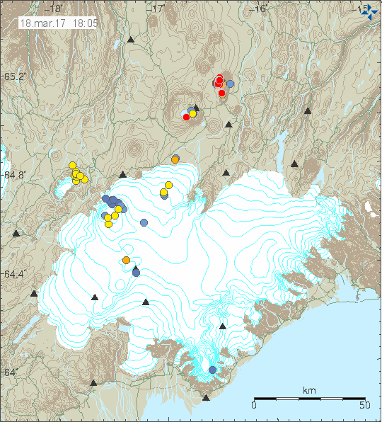
The earthquake swarm close to Herðbreið volcano crater (red dots). Copyright of this image belongs to Icelandic Met Office.
I don’t expect an eruption in this area, since currently there isn’t anything suggesting that magma might be responsible for this activity. This part of Iceland is also outside all major volcano areas, but it might possibly leak magma for some unknown reason. Last eruption in this area took place during the last glacier period in Iceland, when exactly is something I don’t know, but it ended 11.700 years ago. Eruption in this area would also create a larger earthquake activity then is currently happening, due the fact the crust in this area is cold and would require a magma to break it before it reached the surface.
This article is going to be updated if needed.
Donations
Please remember to support my work with donations. Since it takes time to write this articles and try and figure out what is going on in each area when something is going on. Thanks for the support. 🙂
When I look at the erðbreið earthquake swarm on the 3D bulge animation (which is still on line after the Holuhrain eruption) :
http://baering.github.io/
I can see see the earthquakes are at various depths and form a straight column. Does this not look like magma movement Jon?
No, might be a fault strike in the crust. I don’t know the degree angle on it.
You will see it better at this link:
http://baering.github.io/earthquakes/visualization.html
http://www.volcanowatch.co.uk has a longer timeline, and shows that the active area was spreading and getting shallower over the past 10 days, although it now appears to have slowed down.
I’m assuming you are the creator of that website: congratulations, it’s really useful, interesting and helpful. I particularly like the lines connecting earthquakes. Thank you!
Thinking of Sveingjá and everything between Askja and Mývatn? Not the same swarm?
http://mapcarta.com/17598190
Sveingjá might be connected to Mývatn volcano or other nearby volcano.
Actually magma has been slowly pooling under Herdubreid and Upptyppingar within the last decade. Not saying an eruption is going to happen, but it is a definite possibility. Also futurevolc data mentions that Herdubreid is believed to be its own central system with a forming deep feeder system, independent of the Askja system.
Flying over this general area between Möðrudalur and the Holuhraun eruption while filming there I noticed numerous volcanic features and what appeared to be crater rows.
What period does this activity date from? They appeared to be relatively fresh and postglacial but appearances can be deceptive.
This would be from Askja volcano, mostly from 19th century with possible older crater rows in the mix. The fissure swarm of Askja volcano is nearby but does not cross over to Herðubreið according to the maps I have. Same goes for Kverkfjöll volcano fissure swarm that is on the other side to the south-east. Herðubreið is between those swarms according to the maps I have at the moment and outside main eruption areas in Iceland.
That does not rule out an eruption in the area. As the fact is that in Iceland, since an eruption can happen in most places in Iceland due to how volcanoes and magma pockets are spread under Iceland in the mantle.
I once had a image of that, but I guess I’ve lost it over time.
You will see it better at this link:
http://baering.github.io/earthquakes/visualization.html
“Outside all major volcano areas” and yet it sits around 20km from askja! Enough said…
Hello Jon. But you are the only one who says the quake is not magmatic. Carl Rehberg and Marc Sezglat think that they are magmatic. Why can they exclude that they are not magmatic?Because the area is 12,000 years dead?
This just looks tectonic in nature at the moment. In 2014 this area also had an earthquake swarm, over a period of 8 days around 2000 earthquakes took place, largest with a magnitude of 3,7.
Okay, thank you for the information. Then it will probably be tectonic. 🙂
Playing with the data on 3Dbulge it looks like a vertical stack from some angles but on closer inspection it’s more sheet-like – which could be interpreted as a fault plane or as a dyke.
Detailed waveforms for the ‘signature’ of the quakes would clarify.
The interesting question for me is – if tectonic, why does the swarm not extend all the way to the surface? The thing starts around 10km depth and with *very* few exceptions stops at 2km. What’s the nature of the process and the material involved in the transition from seismicity to no seismicity at ~2km?
You can check the raw wave form of this earthquake activity here. Its the best I know of. I’m unable to record all but the largest earthquakes on my geophone and the signal doesn’t even appear properly on it due to distance.
http://www.jonfr.com/webicorders/imodrumploten.html
It’s definitely at least mostly magmatic. The swarm is “stacked”, forming a continuous vertical map when plotted in a 3D diagram. The quakes have been getting shallower over the last week. It does only look like a small intrusion for now but the volcano *may* be slowly on the road to eruption, indeed similar swarms have occurred in the last decade. A large seismic crisis started under the nearby Uptyppingar volcano, with a dike intruding from depth close to the surface, before deflecting horizontally into the Herdubreid area, where it’s believed to have interacted with a remnant magma reservoir from the end of the ice age. Both Herdubreid and Uptyppingar now have fully formed systems, so can be regarded as independent central volcanoes. This is similar to the dyke that intruded under the what was then considered to be extinct Kistufell volcano, which deflected to Bardarbunga, leading to the Holuhraun eruption (Kistufell has continued to inflate during and since the eruption, so again is an active independent volcano). That doesn’t mean Jon is completely wrong, as like in Aug 2014 there’s probably some tectonic “reaction” going on. So all of these volcanoes have awoken from a coma you could say!
So you think a dyke intrusion under Kistufell triggered BB 2014? What we saw at the beginning of that event was this huge swarm and a couple of green stars at Kvjerkfjöll too, the latter didn’t lead to anything. I don’t think Jon wrote about Kistufell back then at any time.
The Kistufell intrusion was just before the big swarm. Basically the intrusion caused overpressure in Bardarbunga’s main chamber, which resulted in the east wall of the chamber failing, which is when the big swarm started. We can see that this is what happened if you look at a map of the progression of earthquakes before the eruption.
That’s the first time this comes up. Kistufell isn’t mentioned in the categories. Not even as a far rumour. Do you have a chart of that intrusion?
Kistufell has had an earthquake activity for a long time before the eruption from Bárðarbunga in 2014. Kistufell is part of the fissure swarm that goes to the north (up to Askja) and makes up Bárðarbunga volcano.
It also appears up on reviewing the older earthquake data from 2014 that pattern of earthquake activity changed in week 20 2014 and continued until the eruption started.
It can be seen from this week onward. If older data is checked the change in activity comes clear.
http://hraun.vedur.is/ja/viku/2014/vika_20/index.html#mark
So hats on for Katla volcano.
I was checking old data and I found this information on earthquake activity in this area from 1997 – 2014.
http://hraun.vedur.is/ja/viku/2014/vika_18/FIG/herdubrtogl97-14.png
Here’s a diagram:
http://www.volcanocafe.org/wp-content/uploads/2017/03/Capture.png
http://www.volcanocafe.org/seismic-unrest-and-the-future-of-volcanism-at-herdubreid/
Off-topic, please keep all replays below this comment. All other normal geology related comments can go in their normal place.
I’ve decided to check out living in Hanover in Germany, with Flensburg as a back-up. The third back-up being Bremen in Germany. What I’m looking for is a housing company that rents out apartments. I don’t like to rent apartment from a private individual. Something in the lines of SBV-Flensburg (link below) or FAB (Flensburg).
http://www.fab.sh/
https://www.sbv-flensburg.de/
I’m sorry for this little off-topic. I’m trying to figure stuff out when it comes to Germany few years before I start the actual planning on moving to Germany.
Thanks for the help. 🙂
This are the searchresults for Hannover:
https://www.google.de/?gws_rd=ssl#q=wohnungsgenossenschaft+hannover&*
Thanks for this. I’ve bookmarked few for later viewing. 🙂
In the news today in Iceland (Bylgjan/DV) they speak to Ármann Höskuldsson that says there are two possibles of what might happen in this area.
1. An eruption might happen in Askja volcano volcano system. Not close to Herðubreið. The reason for this are two magma injections that happened in 2007 and 2008. One is under Upptyppingar and the second is under Álftadyngja, magma injection took place at 14 km depth in this area. Since then nothing much has been happening on the surface (earthquakes), GPS appears to been telling a different story (data that I can’t access easily) . Since 2007 and 2008 this magma deep in the crust has slowly been moving to the west, making its way in what seems to be Askja volcano system. In 2008 the largest earthquake swarm in this area had 2300 detected earthquakes.
Maps and news from Icelandic Met Office can be found here, this is from 2008.
http://www.vedur.is/um-vi/frettir/nr/1272
http://www.vedur.is/um-vi/frettir/nr/1240?ListID=0 (about the magma collection under Álftadyngja/Upptyppingar.)
2. The second possibility is that the crust in the area is adjusting to the Holuhraun dyke and fault that formed during that eruption. If that is the case, it is just going to result in more earthquakes.
Icelandic News: http://www.dv.is/frettir/2017/3/21/armann-segir-ad-eldgos-gaeti-verid-i-vaendum-500-skjalftar-i-hrinunni/
Interesting info and links, Jón. Thank you. I assume you mean Álftadalsyngja rather than Álftadyngja.
We both got it wrong, it’s spelled “Álftadalsdyngja”. Its an old eruption crater in this area.
I found a picture with all the confusing names.
http://hraun.vedur.is/ja/viku/2008/vika_11/ask.gif
Well, yes, we did, but my missing “d” was illiterate!
Picture of the area in question.
http://omarragnarsson.blog.is/blog/omarragnarsson/entry/1047783/
Here is my new video, in light of the Herdubreid activity, a closer look at overall seismicity and how the latest swarm fits in. Data used is from the IMO earthquake catalogue, and only manually checked earthquakes were used.
I recommend watching in full screen and HD.
I am working on a portable version of the software with the packed data, to share it individually, and so it works as a install package together with the data and everything, so the plan is to kinda make it like “plug and play” or “install and spin”. But its not ready yet.
https://www.youtube.com/watch?v=gvOSH70iCIY