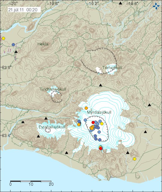
Sometimes there is a strange earthquake activity in volcanoes. I do think that this qualifies as one of that cases. But there has been odd and what appears to be grown earthquake activity in SE part of the caldera rim in Katla volcano.

The earthquake activity is the earthquake spot the SE in Katla volcano, out side the caldera. Copyright of this picture belongs to Icelandic Met Office.
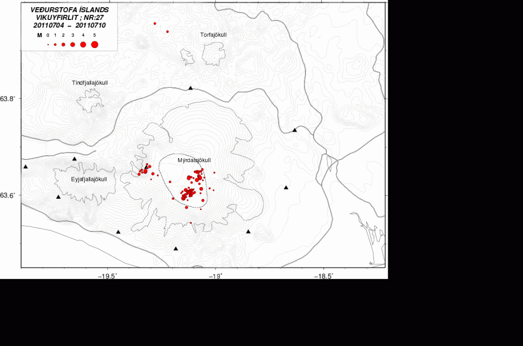
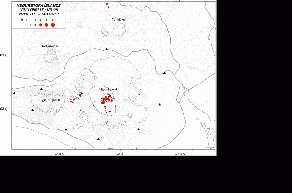
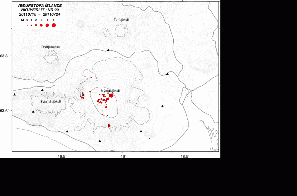
From what I can gather this activity started in Week 27 or about that time. Since then it appears to have been growing in number of earthquakes. I do not know yet if there have been any changes in the area, like hydrothermal activity.

Week 27. One earthquake can be seen in this area. Copyright of this picture belongs to Icelandic Met Office.

Week 28. More earthquakes in the same area. Clear sign that the activity is growing. Copyright of this picture belongs to Icelandic Met Office.

Weeek 29 (crurrent week) . Even more earthquakes at the same location. Copyright of this picture belongs to Icelandic Met Office.
While I do not yet what is going on there. This is something that might be interesting to watch and see what happens. Because small amount of magma might just have found a new pathway up the surface in this area. Even if it does not erupt, this might create new hydrothermal area if this is in fact magma. But given that this is in a volcano and really dense earthquake swarm. It is my guess that it is the case.
Power outage: Due to some maintenance work on the local power grid where I live I lost all power from 01:00 until about 06:20 UTC this morning. But that means that this blog post is late by several hours and my geophone webicorders have been off-line at the same time. Sadly I cannot afford few UPS like this one to keep my system up and running when the power goes out. As I need at least four of them at home and one with each webicorder computer (at location).
I am going to post update on what did happen during the night around 09:00 08:00 UTC. When I know more and after some more sleep.
Blog post updated at 07:29 UTC on 21. July 2011.

Yes Strange indeed and quite scary if I’m honest.
It seems that a shift from SE to NV, (down right to upper left) has taken place between week 27 and week 29.
I was not speaking about that movement. But rather the cluster of earthquakes around SE part of Katla volcano. It is on the edge of the glacier it self.
But in regards to the movement of earthquakes inside the caldera it self. It is really hard to know what that actually means in the short term.
Something seems to have happened last night, looks to me as if the main road has been closed for some time because of increased activity (?) in Katla, but my translation is possibly worse than Google’s.
Icelandic news at: http://www.visir.is/aukin-leidni-i-mulakvisl-og-oroi-i-myrdalsjokli/article/2011110729868
Increased conductivity in Múlakvísl river and increasing tremors it says. I really cant see any big increases in tremor though but there is quite an increase in conductivity in the river through the night.
Thank you for the update Jon. If that spot is a new magma path to the surface we could expect to see a dramatic outburst of water and ice within the field of the Cam View , would I be right about this?. I would expect the flow to be noticed especially in the valley directly below the icecap. I have seen reflections as the sun catches the water so a jökulhlaup would be very noticeable. I continue to watch the glacier’s edge on the cam with interest
Is the wide braided river, directly below the scarp leading up to the glacial top, that can be seen mid left of the Katla cam picture the river Mulakvisi ?
Mulakvisl.. apologies for typos this morning. My brain may be awake but my fingers aren’t!
Could this be something similar to what happened at Eyjafjallajökull in 2010, magma finding a new weak spot to break out away from the centre of the volcano?
If that is the case, then there is going to be a small eruption at that spot. But it is impossible to know if that is going to happen at that place in Katla volcano.
Now we just wait and see.
New blog post is up about what did happen during night.
All the quakes at this interesting point are very shallow and weak. I think it may be due to new hydrothermal activity.
Yesterday I followed your blog-post, as I did July 19th. I remember the discusion about the steam formation at the glacier. Most of you concluded that it was just cloud formation. On July 19th the wind was from right to left on the Katla webcam.
Yesterday I noticed that cloud formation occurred at the same three locations but the wind shifted from left to right. That cloud formation had a periodic nature. About every 3 minutes.
Cloud formation will happen if there’s an increase in water concentration in the air or a decrease in air temperature. If there is water at slightly higher temperatures than the surrounding air you will observe cloud formation. Just look at a lake in the evening. The water is still warm and the air is cooling down. You will see fog formation.
I think that the “steam columns” (July 19th) and the cloud formation yesterday are orriginating from water that is slightly warmer than the surrounding air. The location of one of the spots is (on the webcam) just above the minutes indication in the face of the glacier. I assume that there’s a waterfall with melting water from the glacier.
Yesterday evening, arround 19.30, the cloud formation at this spot stopped.
@ Jón Frímann
Those earthquakes you are talking about in this post are the ones on top of Vesturgil, right?
Vesturgil river/creek goes into Hafursá river. Where Hafursá river leaves the small canion and enters the flatland the riverbead seemes to show clear signs of floods there in the past – which to me seeme to have been more extensive than the annual spring/autumn rain & melting floods. Not as big as in Jökulsá á Sólheimasandi river but quite some flooding though. I think it is possible is has been due to hydrothermal activity or small eruption.
I noticed this when I was traveling there last weekend but I am sure there has been done research on that issue but I have not found that online.
I don’t know what this place is called. But this is a intresting place for earthquakes to suddenly appear.
It is a interesting place, yes.
Here is a link to good map/areal view of Iceland with names of places.
http://atlas.lmi.is/kortasja/
It couldn’t be the volcano Laki thats responible for these floods? And its really her thats gonna erupt? Just speculating…