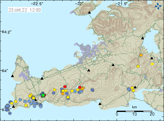
This morning on 23-October-2022 an earthquake swarm took place in west part of Fagradalsfjall volcano. Largest earthquake in this swarm so far had a magnitude of Mw3,0.
Earthquake activity west of Fagradalsfjall volcano. Picture from Icelandic Met Office.
This earthquake activity is the result of magma pushing up into the crust at around 5 km depth. This is not a large dyke intrusion and possibly won’t result in a eruption, unless there’s a sharp increase in earthquake activity and that has happened (the August 2022 eruption started this way). This is currently a situation that requires monitoring for changes. If anything is going to happen is impossible to know.
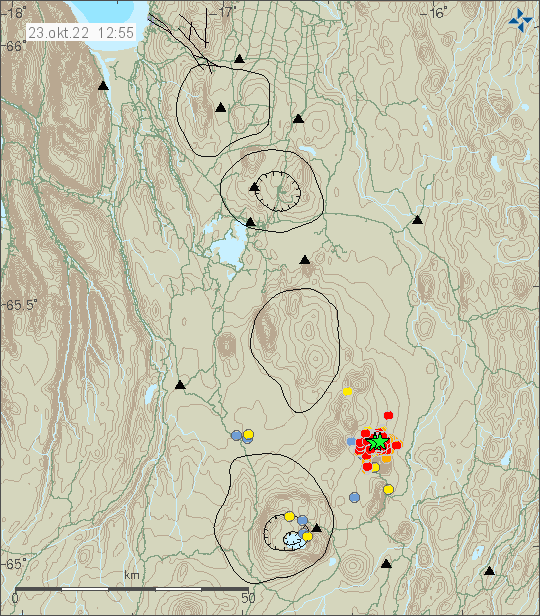
During the night of 23-October-2022 an earthquake swarm started north of Herðubreið mountain. This looks like a tectonic earthquake swarm, rather then a magma related activity. At the writing of this article, over 500 earthquakes have been recorded.
Earthquake activity north of Herðubreið mountain. Picture is from Icelandic Met Office.
Largest earthquake at the writing of this article had a magnitude Mw4,0 and one magnitude Mw3,1 earthquake took place. Second largest earthquake had a magnitude of Mw3,3. This earthquake swarm is ongoing at the writing of this article and there’s still a risk of larger earthquakes happening north of Herðubreið mountain. The largest earthquake was felt in Akureyri according to news reports.
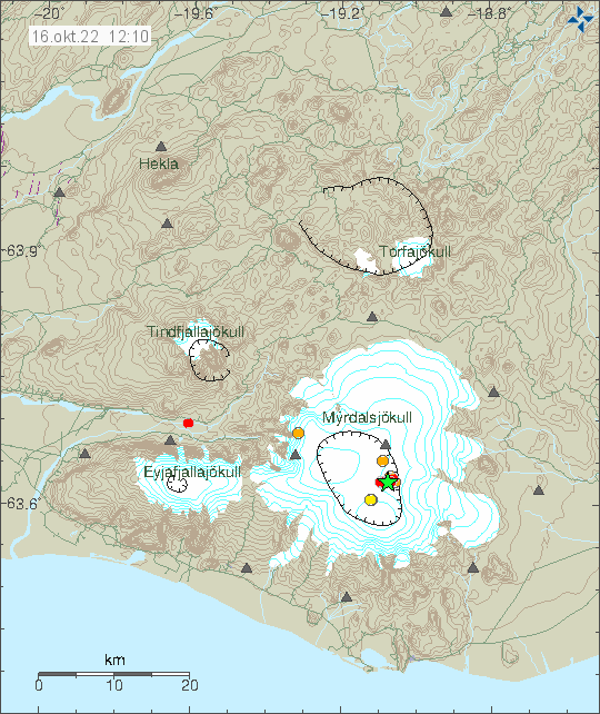
Today (16-October-2022) an earthquake swarm started in Katla volcano in Mýrdalsjökull glacier. Largest earthquake at the writing of this article had a magnitude of Mw3,8. I don’t know if it was felt in nearby towns and farms. Second largest earthquake had a magnitude of Mw3,0.
Earthquake activity in Katla volcano. Copyright of this image belongs to Icelandic Met Office.
This earthquake swarm is ongoing at the writing of this article and the situation can change quickly. This might be a normal earthquake swarm and nothing more might happen. This type of earthquake swarm is not uncommon and I am not sure what is required for an eruption to start in Katla volcano.
Around 10:00 UTC this morning (31-October-2021) the earthquake activity of long period and low frequency earthquakes increased this morning in Torfajökull volcano. The current swarm now seems to be coming from the glacier part of the caldera, the earlier activity seems to have taken part some place in north part of the Torfajökull volcano caldera. Location of the this earthquake activity is difficult if not impossible because of the type of earthquake activity being generated in Torfajökull volcano.
The located earthquake activity in Torfajökull volcano. Copyright of this image belongs to Icelandic Met Office.
The situation is difficult to figure out just by looking at seismometer data. Icelandic Met Office is going to make a flyover today with the help of Icelandic Coast guard and try and see what is going on in Torfajökull volcano. Last eruption in Torfajökull volcano was in the year 1477 and I don’t have any idea what happens before an eruption in this volcano.
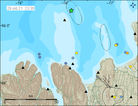
Yesterday (28-October-2021) an earthquake swarm took place east of Grímsey island. The largest earthquake had a magnitude of Mw3,9 at 22:06 UTC. It is not know if it was felt in Grímsey island.
Earthquake activity east of Grímsey island. Copyright of this image belongs to Icelandic Met Office.
Earthquakes are common in this area and large earthquake swarm happens in this location every 2 to 10 years.
Yesterday (30-August-2021) an small earthquake swarm took place east of Grímsey island in Tjörnes Fracture Zone. Two largest earthquakes had a magnitude of Mw3,2.
Earthquakes east of Grímsey island. Copyright of this image belongs to Icelandic Met Office.
This earthquake swarm seems to have stopped for now. This area has frequent earthquake swarms and activity in this area of Tjörnes Fracture Zone might start again without warning.
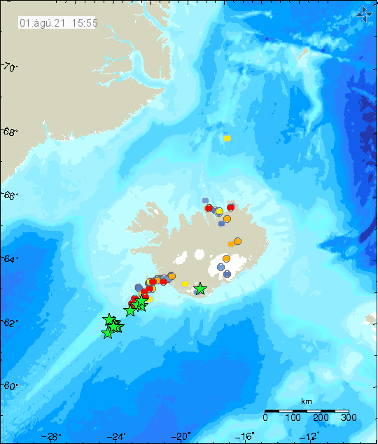
At midnight on 1-August-2021 an earthquake swarm seems to have started deep on the Reykjanes ridge. The current distance seems to be around 220 km away from Reykjavík or 190 km from Grindavík town. At this distance the location from Icelandic Met Office are not accurate. At the writing of this article the earthquake swarm seems to be ongoing.
The earthquake activity as it is shown on Icelandic Met Office map. Copyright of this image belongs to Icelandic Met Office.
Largest earthquake recorded at the writing of this article had a magnitude of Mw5,2 and the rest of the earthquakes have magnitude between Mw4,0 and Mw4,8. Overview of this earthquake activity can be found here on EMSC website. This links works as I publish this article. How long it is going to work I don’t know.
The current distance makes it impossible to know for sure what is going on at this location. The pattern of this earthquake activity suggests that this might be earthquake activity because of magma movement in the crust, but there is not any way to confirm this because of the location. Even if there is an eruption at this location it won’t make any difference to the surface of the ocean, since depth of the ocean at this location is more than 1 km. I don’t know the exact depth.