Glacier flood from Grímsvatn lake on Grímsfjall volcano

It has just been announced in the news that Grímsvant glacier lake has just had an glacier flood, but this lake is in the Grímsfjall volcano caldera. This glacier flood is believed to have started yesterday around 12:00 UTC. The glacier river that the water is running into is called Gígukvísl. So far this appears to be minor flood so far. But I do not know how much water as in Grímsvatn lake when this flood did take place.

At current time it is impossible to know if an eruption is going to take place following this glacier flood from Grímsvatn lake in Grímsfjall volcano.

I am going to post more information about this as I get them.

Icelandic news about this. Use Google Translate if you want to get incomprehensible news about this event.

Líklegt að Grímsvötn hafi hlaupið (Vísir.is)
Hlaup í Gígjukvísl (Rúv.is)
Jökulhlaup í Gígjukvísl (mbl.is)

No eruption starting in Hamarinn volcano

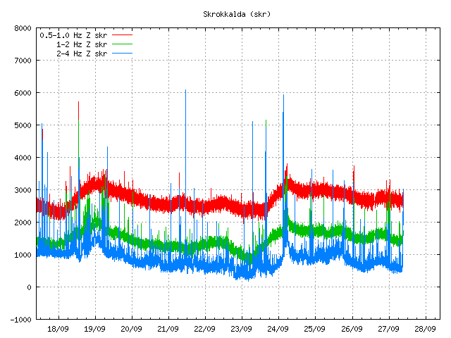
There seems to be a minor eruption starting in Hamarinn volcano (might be part of Bárðarbunga volcano). Given the current tremor signature on Skrokkalda SIL station.


The start of a harmonic tremor spike on Skrokkalda SIL station. Most likley from Hamarinn volcano. Copyright of this picture belongs to Icelandic Met Office.

For the moment I do not know if this is going to remain a small eruption or might evolve to larger eruption. That is going to come clear in next several hours. But for the moment this is starting and glacier flood is to be expected in several hours. There is no danger to humans or humans structures I think.

Update 1: Darn! False alarm!

This is how the tremor plot did look after one update.


The tremor spike just changed into regular earthquake so to speak. So this is nothing but false alarm. It happens. Copyright of this picture belongs to Iceland Met Office.

Blog post updated at 09:59 UTC on 27. September 2011.

Small eruption took place in Katla volcano in July 2011

According to the news on Rúv this evening it is now a opinion at Icelandic Met Office that a small eruption did take place in Katla volcano during the days 8 and 9 July 2011. This eruption was however larger then the eruption in Fimmvörðuháls in Eyjafjallajökull volcano last year (2010). But this is based on tremor data from around Katla volcano during this summer. But this is what Einar Kjartansson geologist at Iceland Met Office says in the news at Rúv this evening. Even if this small eruption did take place in Katla volcano it does not seems to have eased the pressure inside Katla volcano, so a large eruption in Katla volcano is still a possibility in the close future. Note: GVP has updated Katla volcano eruption status to the year 2011!

This conclusion was reached by checking out the cauldron that formed during this event. But they show a sign that they had a sudden melt taking place. But that melt can only happen of lava got into contact with the ice and fast melted it. This is also the reason why there was a 5 meters flood in Múlakvísl glacier river that did destroy the bride over it. But it is also a fact that the harmonic tremor in Katla volcano during this period was the same as that did happen during the eruption in Eyjafjallajökull volcano. The only difference was that it it was stronger from Katla volcano then in Eyjafjallajökull volcano it seems (at least from what I can see from the data). Even if it lasted for a shorter time then in Eyjafjallajökull volcano.


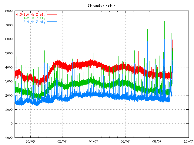
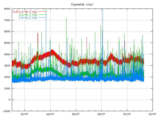
The tremor on Slysaalda SIL station on 9 July 2011 at 00:36 UTC. Copyright of this picture belongs to Iceland Met Office.


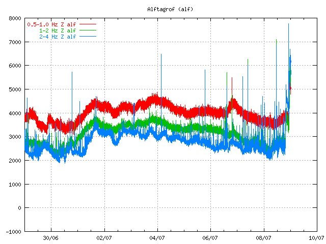
Alftagrof SIL station on 9 July 2011 at 00:36 UTC. Copyright of this picture belongs to Iceland Met Office.


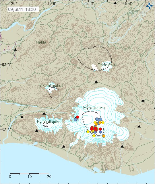
The area that was active and had a eruption on 8 and 9 July 2011. Copyright of this picture belongs to Iceland Met Office.

Even with this small eruption it is clear that Katla volcano is not done with its eruptions. Since the large one is not yet over. When that happens is a good question and nobody has a answer too at the moment.

Note: This is also what did happen in Hamarinn volcano the week after. But I also think that volcano did have a minor eruption in July 2011. As the signatures are the same from what I can gather. So that makes three eruptions in Iceland for the year 2011 if confirmed later on.

Icelandic News with this. Use Google translate with care on it. Since it does not understand.

Allt bendir til Kötlugoss (Rúv.is, Icelandic, Picture)
Segir Kötlu hafa gosið í sumar (DV.is, Icelandic, Picture)
Lítið eldgos í Kötlu í sumar (mbl.is, Icelandic)

Most likely water creating harmonic tremors in Katla volcano (for the moment)

In the news from Rúv at 22:00 UTC it was sad that water is the most likely source of the harmonic tremors in Katla volcano. But it seems that hydrothermal activity in Katla volcano is increasing and melting the glacier. But for the past few hours there have been signs of hydrothermal melt water getting into Múlakvísl glacier river, making the river have more water then normal and increasing conductivity in it. This is not glacier flood as such. The cauldrons that formed in July have not changed according to this news, but it was not reported if they had actually gotten deeper or larger.

Due to cloud cover it was not possible to explore the north part of Mýrdalsjökull glacier. Just the south part. According to the news on Rúv at 22:00 new small cauldron have formed in the south part of Mýrdalsjökull glacier. They are shallow at present time and may have taken few weeks for form to present size (not sure how big they are), but among this cauldrons is a cauldron that has not been seen for past seven to eight years, cracks have formed around the cauldron and he has gotten deeper and water has collected in the cauldron. But with more earthquake activity and increased hydrothermal activity under the glacier. So more monitoring is needed on Katla volcano according to Magnús Tumi Guðmundsson volcanologist at University of Iceland.

Note: When I wrote this blog post. It seems that new earthquake swarm is about to start in Katla volcano. At least I think so.

News about this events in Icelandic. Use Google translate if you want to insult the Easter-bunny.

Telja að vatn valdi óróa (Rúv.is)
Engin augljós skýring á óróa (mbl.is)
Jarðhiti aukist mjög mikið undir Kötlu – dæmigerð einkenni að menn eigi að búa sig undir gos (Vísir.is)

Increased earthquake activity in Katla volcano during the past year

In todays news at Rúv News there was a report about Katla volcano. This news has a interview with a Einar Kjartansson geologist at Iceland Met Office about the earthquake activity in Katla volcano. Einar speaks about the earthquake activity in Katla volcano yesterday (3. September 2011). But he also speaks about how activity in Katla volcano has been increasing during this year and it is more then it is normal in Katla volcano. But it is important fact that Katla volcano always has earthquake actvitiy, even with earthquakes up to ML4.5.

He also says that this increased earthquake activity in Katla volcano is due to dike intrusion into Katla volcano or some other activity that is currently taking place in Katla volcano.

Flood in Múlakvísl glacier river

During yesterday and during the night there was a glacier flood in Múlakvísl glacier river. This time around it was not connected to the activity in Katla volcano. But due to heavy rain in this area and melting of the glacier in the heat that has been in Iceland for the past few days. Since then the flood has subsided and Múlakvísl glacier river is back to normal and the flood has subsided.

News about all this.

Aukin skjálftavirkni í Kötlu (Rúv.is, Icelandic)
Braut niður varnargarð (mbl.is, Icelandic)
Miklir vatnavextir í Múlakvísl (Vísir.is, Icelandic)

Overview of Hamarinn volcano current activity

Here is a short overview of the Hamarinn volcano activity this summer. From what I can gather in the current data this is most likely not over. During the past few days there have been at least suspected two minor eruption in Hamarinn volcano. But it hard to confirm it due to glacier that is covering this area.

This all starts on 12. July 2011 at 07:30 UTC with this event here.


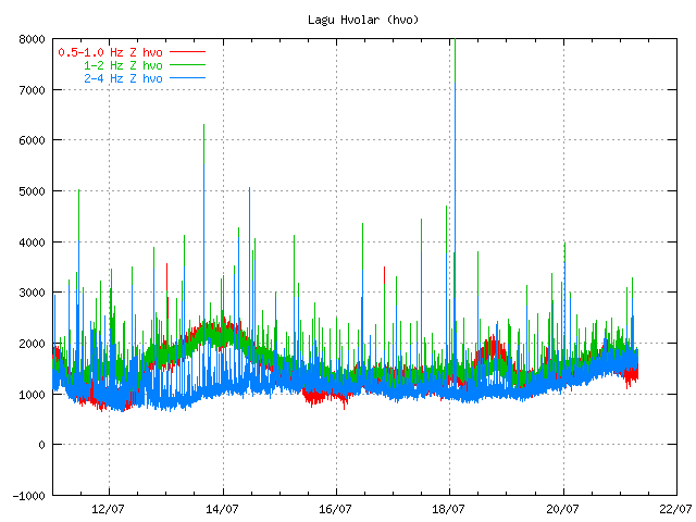
The tremor spike on 12. July 2011 at 07:49 UTC. Copyright of this picture belongs to Icelandic Met Office.

When the clock is around 19:10 UTC the same day the tremor chart looks like this.
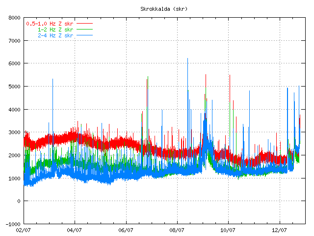

The tremor spikes are now three on 12. July 2011 at 19:09 UTC. Copyright of this picture belongs to Icelandic Met Office.

On the 13. July 2011 the tremor plot looks like this. But at that time the glacier flood had started and broken from the Vatnajökull glacier.
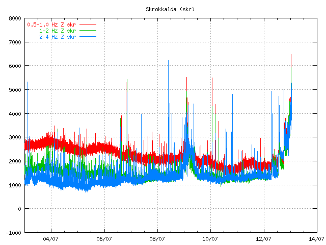

The tremor chart at 13. July 2011 at 01:10 UTC. Copyright of this picture belongs to Icelandic Met Office.
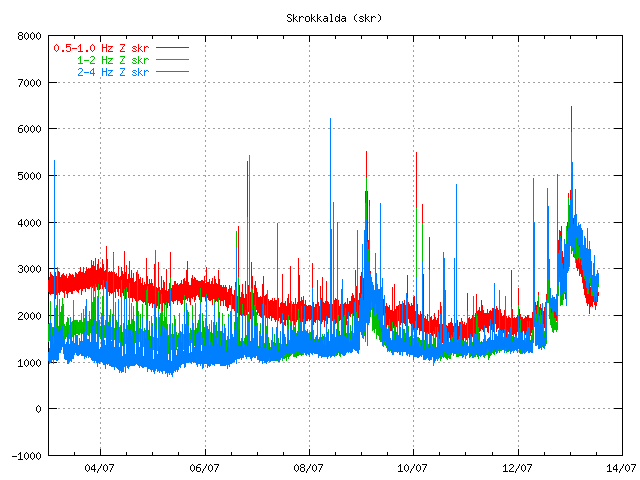

The tremor chart at 13. July 2011 at 12:59 UTC. Copyright of this picture belongs to Icelandic Met Office.

Then there was a short period of break when nothing interesting happened in Hamarinn volcano. That break did last until 16. July 2011 when a new, but smaller spike did appear on Skrokkalda SIL station.
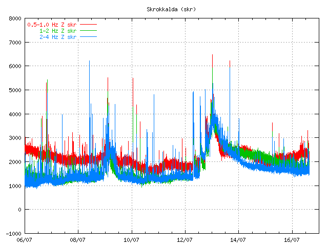

The tremor at 16. July 2011 at 15:22 UTC. It is not fully clear what did happen at this time. But this was most likely a earthquake in Hamarinn volcano. But that is yet unconfirmed at this time. Copyright of this picture belongs to Icelandic Met Office.

Then there is a new break that lasts until 1. August when a earthquakes happens deep under Bárðarbunga volcano. But the deepest earthquake had the depth of 25.2 km. But it is also important to notice this earthquake that took place on 13. July 2011 and it is from Hamarinn volcano.
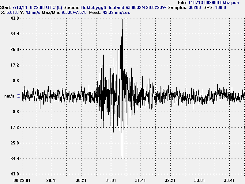

The earthquake from Hamarinn volcano. This picture is released under Creative Commons licence. Please see licence web page for more details.

On the 3. August 2011 around 02:00 UTC a new harmonic tremor spike starts to be visible on Skrokkalda SIL station.
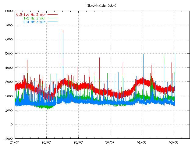

The tremor plot at 01:55 UTC on 3. August 2011. Copyright of this picture belongs to Icelandic Met Office.

This day two minor harmonic tremor happens. A change in Skaftá glacier river is noticed. That is higher conductivity and slightly more water. It was announced in the news that a Skaftá glacier river flood was about to start from the eastern glacier cauldron that is formed above the Hamarinn volcano. Today however that does not seem to be the case. As no glacier flood has taken place so far.

Today (5. August 2011) there was a new harmonic tremor spike on Skrokkalda SIL station. It did follow the same pattern as before. It started and lasted for about 20 to 60 minutes or about that long.
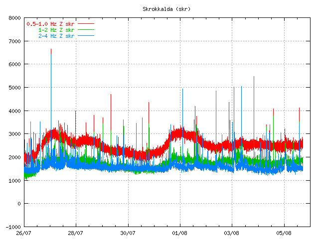

The tremor chart 5. August 2011 at 17:38 UTC. Copyright of this image belongs to Icelandic Met Office.

So far today only one harmonic tremor has been detected. But given the past experience that is unlikely to hold for a long time now. But it is impossible to know when a new event starts or how big it is going to be.

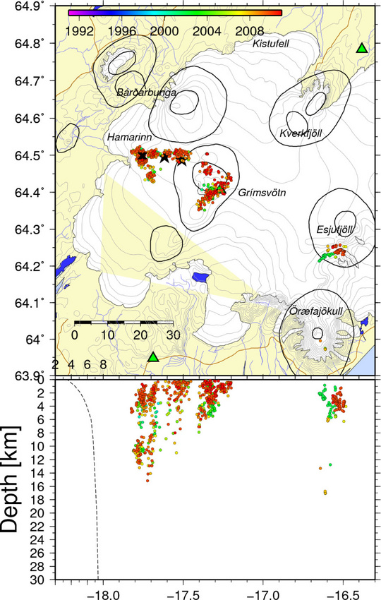
The original event on 12. July 2011 did create new cauldron in the glacier. This map from Icelandic Met Office shows the location of those new cauldrons. But it has been marked with a star on the map. The coloured dots are earthquakes in this area over the past few years.


Map of the area that is currently active in Hamarinn volcano. Copyright of this image belongs to Icelandic Met Office.

Given the current data I am expect a full scale eruption in this area soon. When is hard to know for sure. But until that happens there are going to be more smaller eruptions in this area. I do not know why there is a lack of earthquakes following this events. I cannot explain it. But because of that this can only be seen after it has started on the tremor charts.

No glacier flood yet from Hamarinn volcano, but it is on it’s way

At current time (around 20:30 UTC) it has been observed that no glacier flood has started in Skaftá river. But the glacier flood is expected to start in the river around midnight, but the river might start to grow around 19:00 to 21:00 UTC. According to latest news the river has however started to get darker and conductivity in the water has started rise since this morning, but that was the signal that a glacier flood was about to start. Glacier flood tremor have also been dropping in the last few hours according to the latests news that I have seen (but I am hoping for a update on that detail).

The source of this glacier flood is a hydrothermal area in Hamarinn volcano (part of Bárðarbunga volcano). This area also did have a glacier flood last year. But last year there where two glacier floods in Skaftá river in June 2010, see reports here in Iceland at Icelandic Met Office web page.

This hydrothermal area in Hamarinn volcano is in two cauldrons in the Vatnajökull glacier. With time they fill with water that then breaks ice when the pressure is enough in the cauldrons due to water levels. It remains a question if the surprise glacier flood earlier this month from Hamarinn volcano has something to do with this. But at current time that is only speculation. But if the hydrothermal area is unusually highly active, or there has been some change it is hard to know for sure the size of this glacier flood.

Currently however the experts are expecting a small glacier flood due the fact there where two glacier floods from this area last year. But we however have to wait until midnight until we know what is the actual size of this glacier flood.

Icelandic News about this

Skaftárhlaup ekki enn hafið (Rúv.is)
Skaftárhlaupið komið í byggð eftir sólarhring (Vísir.is)
Engin merki um hlaup ennþá (mbl.is)

Small glacier flood from Mýrdalsjökull glacier (Katla volcano)

During the night (and when I had unstable power) there was a small glacier flood from Mýrdalsjökull volcano. Some minor harmonic tremor change was detected following this glacier flood. This even was small one, many times smaller then what did happen on the 8 to 9 July 2011. Due to security concerns the Civil Emergency Authority did close the main road in Iceland for this area. Since they never know how big the flood can actually be. The main road was closed for about one hour. This glacier flood was detected around midnight 20 to 21 July 2011.

This flood is actually so small it is hard to see it on the harmonic tremor plot from the SIL stations around Katla volcano.


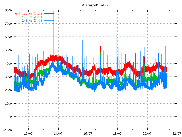
Tremor plot from 07:50 UTC this morning. It is hard to see the harmonic tremor from this minor glacier flood. Copyright of this image belongs to Icelandic Met Office.


Tremor plot from 07:50 UTC this morning. It is hard to see the harmonic tremor from this minor glacier flood. Copyright of this image belongs to Icelandic Met Office.


Tremor plot from 07:50 UTC this morning. It is hard to see the harmonic tremor from this minor glacier flood. Copyright of this image belongs to Icelandic Met Office.

What happens next is impossible to know for now. But it seems that activity continues to be high in Katla volcano. All that can be done is to wait and see what happens. But I am going to continue to monitor the changes in Katla volcano as best that I can do until I finish my summer job (29. July).

Icelandic News about this.

Aukin leiðni í Múlakvísl og órói í Mýrdalsjökli (Vísir.is, Icelandic)
Náið fylgst með Mýrdalsjökli (mbl.is, Icelandic)
Hringvegurinn opinn á ný (Rúv.is, Icelandic)
Breytingar í Múlakvísl (Rúv.is, Icelandic)

Possible minor eruption in Hamarinn volcano yesterday. Update on Katla volcano

There appears to be more in this new hydrothermal activity in Hamarinn volcano then at first sight. It seems that this actually might have a eruption in Hamarinn volcano (Bárðarbunga volcano). If this event is confirmed, this is the first eruption in Hamarinn volcano since the year 1910.

This also mean that there is a chance of more activity in this area in coming weeks or months. But when it might happen is impossible to know.


The new cauldrons are marked with a “X” on this map. Copyright of this picture belongs to Icelandic Met Office.

This eruption was really small and did just last for few hours. But it was able to melt a lot of ice and create rather large glacier flood from Vatnajökull glacier. If the activity resumes in this area this is going to repeat it self in terms of glacier flood.

Icelandic News about this event.

Innskot af kviku (Rúv.is, Icelandic)
Eldgos gæti hafa brotist upp við Hamarinn (Vísir.is, Icelandic, Pictures)
Fundu nýjan sigketil (mbl.is, Icelandic, Pictures)

Sigketill við Lokahrygg (Icelandic Met Office, Icelandic, Pictures)

Update on Katla volcano

Here is a short update on Katla volcano. There have been repeated short burst of harmonic tremors taking place inside the Katla volcano caldera. This harmonic tremor spikes have been small and they are hard to see on the harmonic tremor graph that Icelandic Met Office has on-line. Other then this it has been quiet so far in Katla volcano.

New hydrothermal area found in Vatnajökull glacier

After the glacier flood that took place last night and today the source of this flood has finally been found. According to the news the source of this flood is a new hydrothermal area inside the Bárðarbunga fissure swarm. But this new hydrothermal area is located in Hamarinn volcano (also known lokahryggur or Loki-fögrufjöll), sadly the news does not say exactly where it is located. Just that it located in western Vatnajökull glacier. This flood did go down the river Sveðju and into the Hágöngulón lake (human made lake) that did swallow it whole according to the news. The overflow after the dam lake was full did go into an even larger natural lake, that did not feel any effects of this glacier flood.

In terms of size this glacier flood was larger then the glacier flood in Mýrdalsjökull glacier last week. But that was only about 2000 m3/sec, but this was somewhere around 2200 m3/sec. But this are the numbers that I have seen in the news. But this are not confirmed numbers and might be subject to change on later date.

Other then this activity. It has been rather quiet in Iceland in terms of earthquake and volcano activity.

Icelandic news about this.

Áður óþekkt jarðhitasvæði fundið (Rúv.is, Icelandic)
Virkjunarlónin gleyptu gríðarstóra flóðbylgjuna (Vísir.is, Icelandic)

Órói við Lokahrygg í Vatnajökli (Icelandic Met Office, Icelandic, Pictures)