Increased earthquake activity in Reykjanes volcano

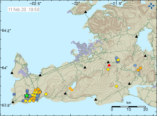
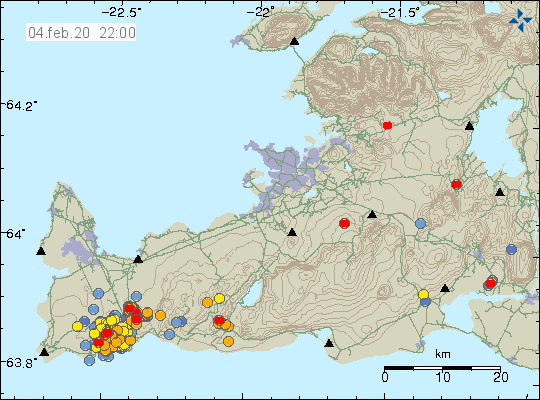
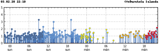
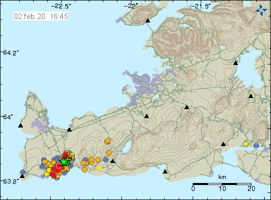
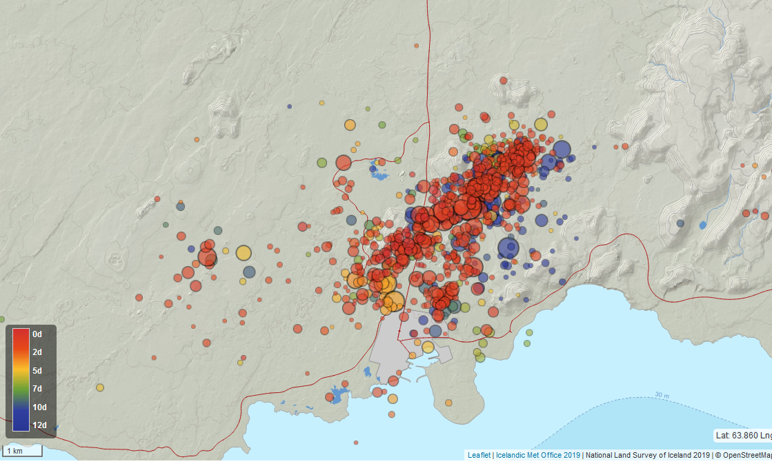
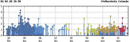
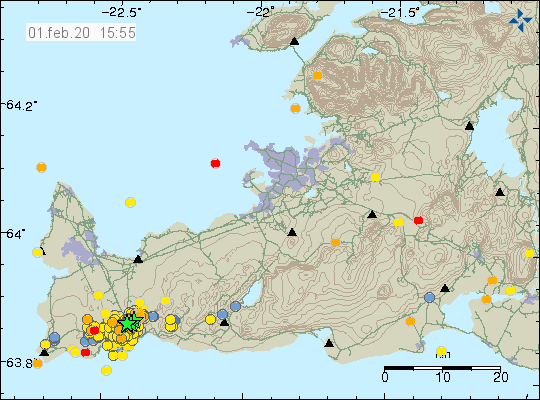
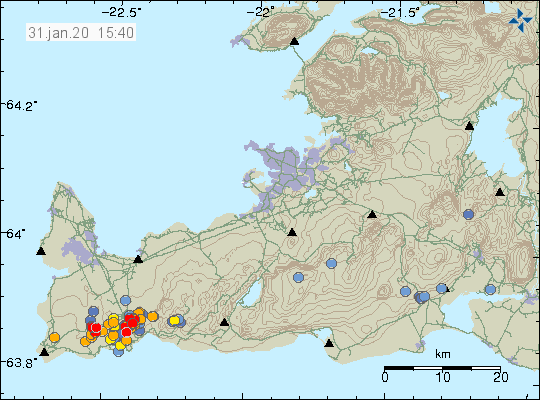
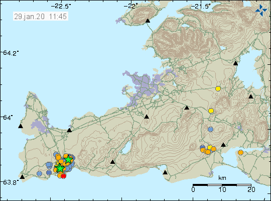
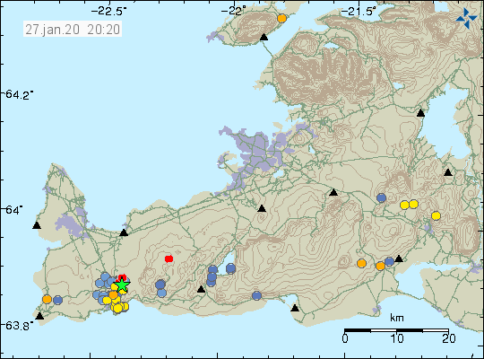
Today (17. February 2020) there has been a increased earthquake activity in the volcano called Reykjanes that is west of Þorbjörn mountain close to Grindavík town. Most of this earthquake activity is small with largest earthquakes having magnitude of Mw2,8. Over 160 earthquakes have happened today. Earthquake activity is ongoing so this numbers are going to change quickly.


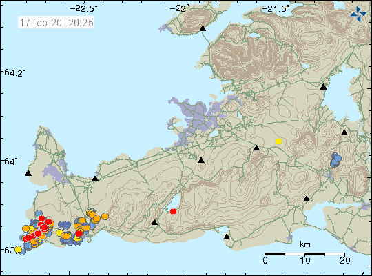
The earthquake activity today. Reykjanes volcano is located to the far west on this image. Copyright of this image belongs to Icelandic Met Office.

Inflation continues in this area without a change and has now reached more than 60mm close to Þorbjörn mountain area. I don’t know for sure how much inflation has now taken place in this area.

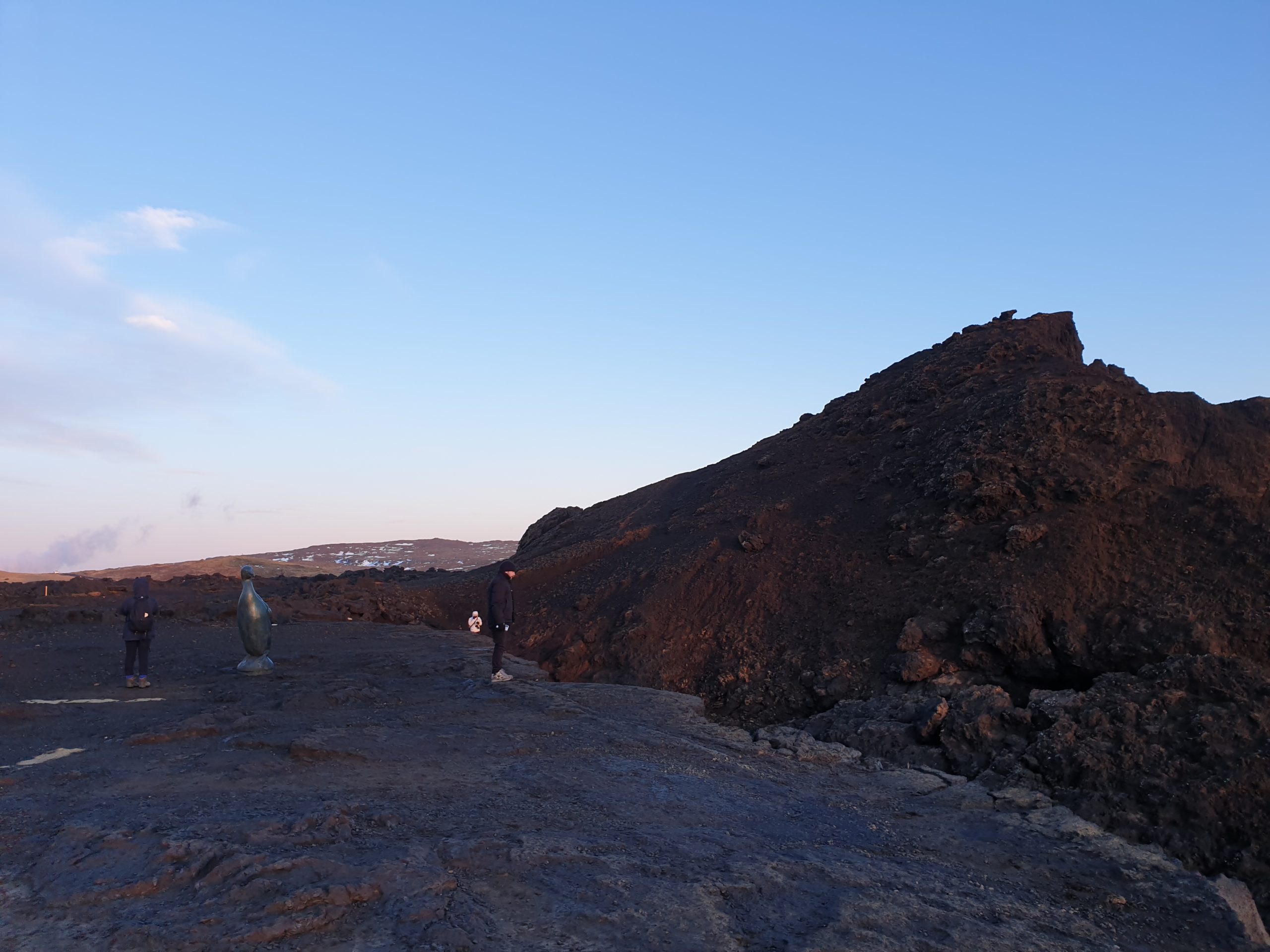
Pictures of the area with the earthquakes

Today (17. February 2020) I did go to this active area to take few pictures. I didn’t get many pictures because the weather was cold and windy. All pictures are taken by me.


The Reykjanes and the Atlantic ocean. Copyright Jón Frímann Jónsson


The rock cliff of the coastline. Copyright Jón Frímann Jónsson


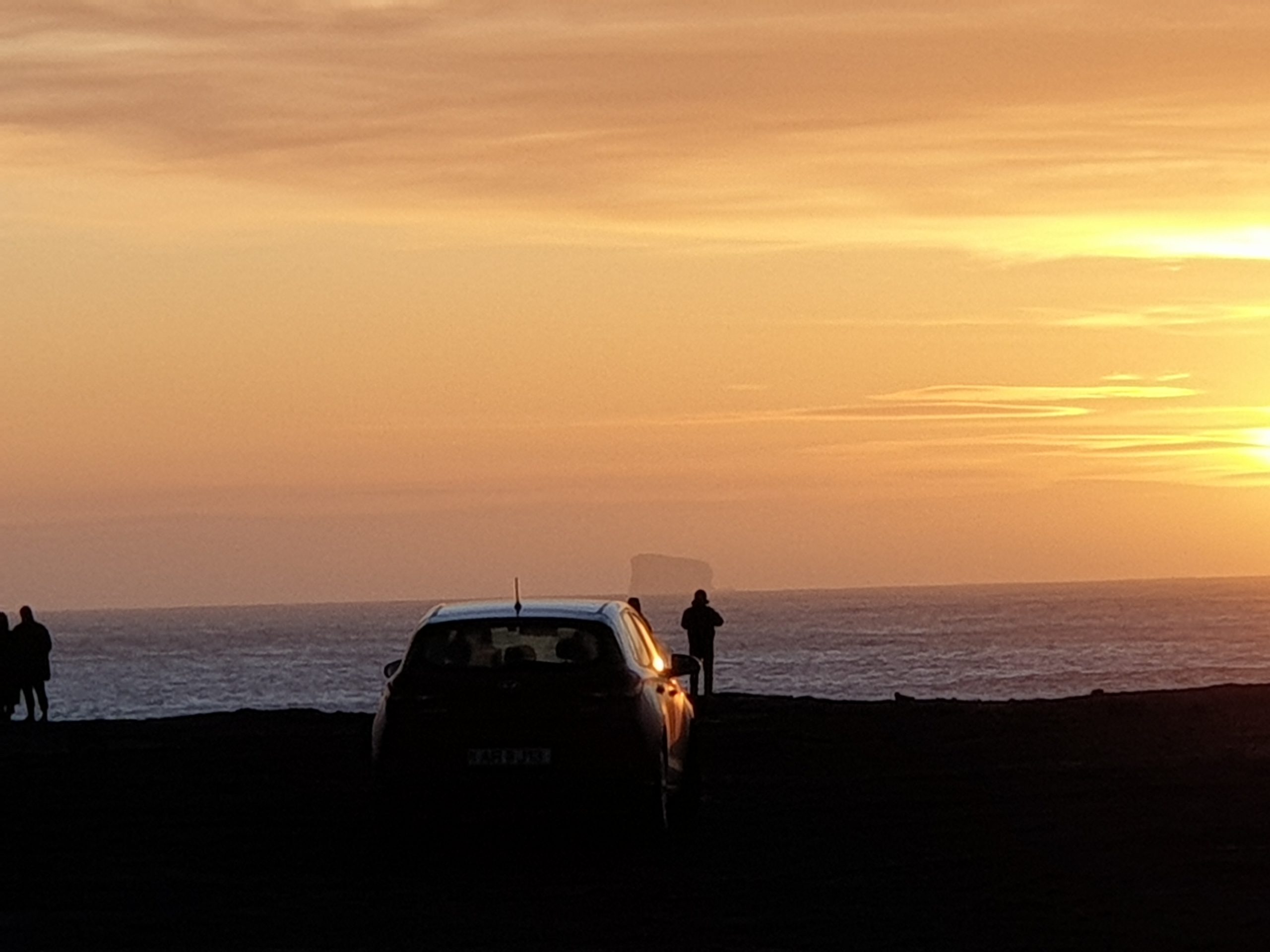
Eldey island at a distance. Copyright Jón Frímann Jónsson


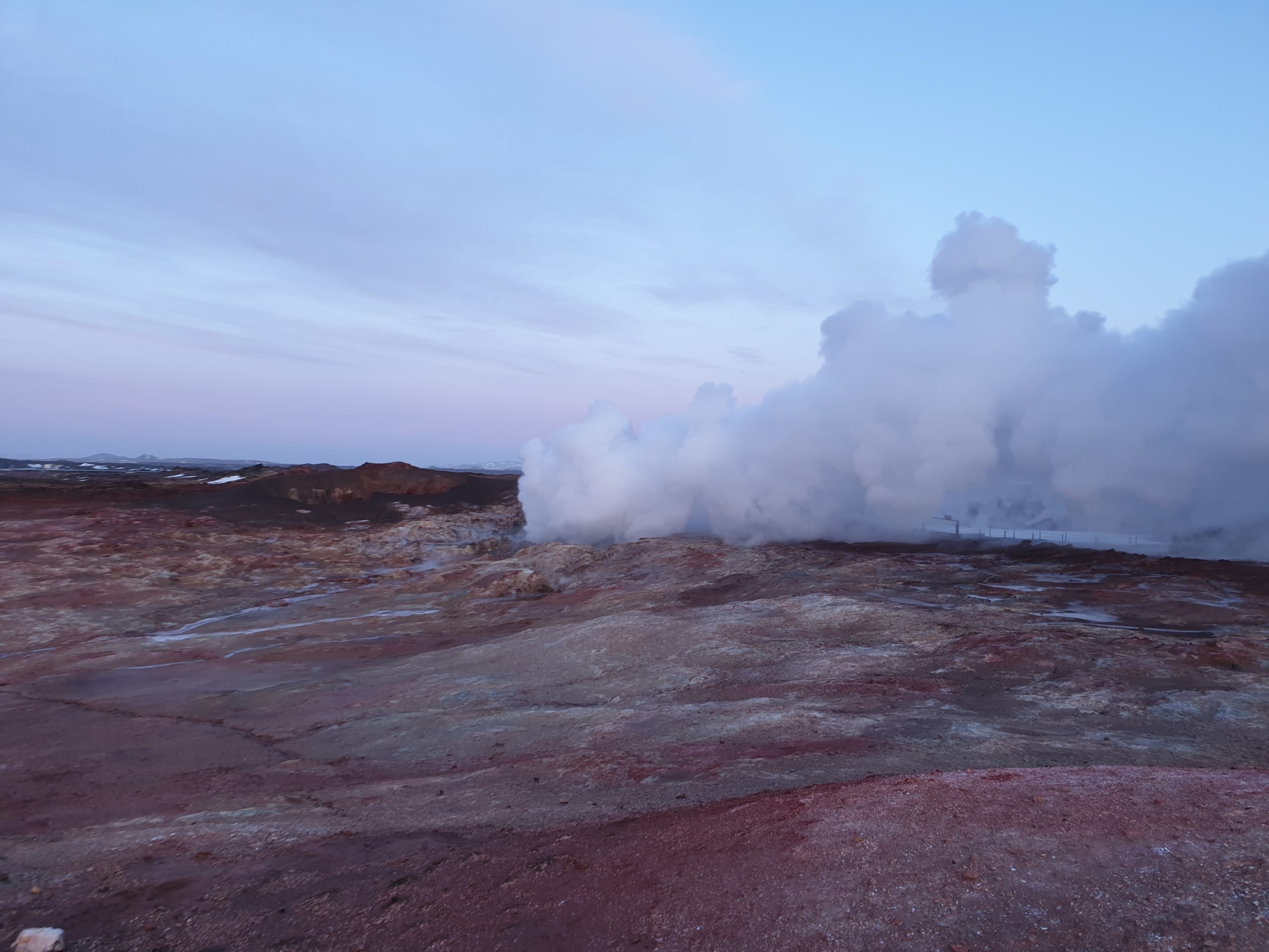
Gunnuhver hot spring. It makes steam. Copyright Jón Frímann Jónsson

More pictures and a video can be found on my Instagram here.

Donations

Please remember to support my work. The second half of February is going to be really broke for me because of moving back to Iceland and other low income related problems. Just donate if you can do so. Thanks for the support. 🙂

Earthquake activity starts in Reykjanes volcano (west of Grindavík town)

Yesterday (14. February 2020) an earthquake with a magnitude of Mw3,1 took place west of Grindavík town. This is just one of many earthquakes this is area as earthquake activity is now continuous and shows no sign of stopping. There has also been increase in earthquake activity in the volcano named Reykjanes (far west of Grindavík town). Þorbjörn mountain is on a top of a different volcano. It seems that both volcanoes in this area are getting active and that is not a good thing.


Earthquake activity in this area. Notice all earthquakes have the direction south-west to north-east. Copyright of this image belongs to Icelandic Met Office.

This situation is getting more complicated and the rate of inflation has slowed a little in recent days while there has been increase in earthquake activity at the same time. The increase in activity in the most west volcano (Reykjanes volcano) makes the situation more dangerous as an eruption the western volcano are going to happen mostly out in the ocean and that is going to result in a volcano ash cloud for a longer or short time period.

What has now started is going to take months since it did not go the quick route with this inflation and magma activity.

Donations

Please remember to support my work if you can with donations. Thanks for the support. 🙂

Earthquake with magnitude Mw3,1 north-west of Grindavík town

Today (11th February 2020) an earthquake with magnitude Mw3,1 took place north-west of Grindavík town in the volcano of Reykjanes. A second earthquake with magnitude Mw2,6 also took place at the same location.


Current earthquake activity around Grindavík town (Þorbjörn Mountain). Copyright of this image belongs to Icelandic Met Office.

Earthquake activity in this area remains the same and is mostly minor earthquakes and that is not a surprise for me. This earthquake activity is in a new area following this magma intrusion and inflation in this area.

Article in wrong place

I did discover that an Icelandic earthquake article had found its way to this website. I don’t know how I got the two websites mixed up. But I have now corrected this and it is on the correct website.

Donations

Please remember to support my work with donations if you can. Thanks for the support. 🙂

Earthquake activity update for 4th February 2020 for Reykjanes volcano

Today (4th February 2020) there has not been a huge change in activity in Reykjanes volcano. Today’s earthquake activity has only been minor earthquakes and around 100 have happened today. There is no change in harmonic tremor on nearby SIL stations so magma is not moving towards the crust. Current inflation is around 55mm to 60mm. The only noticeable change in last few hours is that area of earthquake activity seems to be pushing it self a little more north-east. There has not been any change in the south-west part of the active area.


Earthquake activity in the Reykjanes volcano today (4th of February 2020). Copyright of this image belongs to Icelandic Met Office.

There is a possibility that this is going to be a long process before an eruption happens. It is a long time since an eruption last took place (but no time at all in geological time scale) in this area. It also takes the magma a while to get to the pressure levels needed for an eruption and at current amount of magma it might not be enough to start an eruption in this area.

While there is no major change between days or earthquake activity I am going to have fewer updates since too many articles about the same thing is not good and I know this from experience when Bárðarbunga volcano erupted in 2014 to 2015.

Donations

Please remember to support my work with donations if you can. I am also seeing that February is going to be a annoying broke month for me. Donations help me to keep this website updated and to keep an watch for what is happening in Icelandic geology. Thanks for the support. 🙂

Moving back to Iceland

I move back to Iceland next week. That might result in limited updates the days that I am moving (14th to 18th of February) if something happens on the Reykjanes peninsula in that time. I’ll try to update best I can during this time. Normal updates start soon as I get all my belongings back from transport by the start of March. At the same time I’ll fix errors with my geophone so I can start recording earthquakes again and provide updates of earthquake activity in Iceland in more details.

Earthquake update for Grindavík town (Þorbjörn) on 3rd February 2020

Yesterday (2nd February 2020) a magnitude Mw3,3 earthquake took place north of Grindavík town at 19:04 UTC. It was felt in Grindavík and nearby area as all earthquakes of this magnitude. Today (3rd February 2020) the day has mostly been quiet and there have only been minor earthquakes in the Þorbjörn mountain area and the area close to Grindavík town. The volcano that is now active is called Reykjanes and this is the second volcano of two in this system. The first volcano is mostly under the ocean and is possibly active but exact status remains unknown. Since around 10:00 UTC there have been small earthquake activity, since around 18:00 UTC earthquake activity has started to increase again and is ongoing as the writing of this article. Inflation is now at 50mm to 55mm.


Current earthquake activity close to Grindavík town. Copyright of this image belongs to Icelandic Met Office.


Current earthquake activity rate close to Grindavík town. Copyright of this image belongs to Icelandic Met Office.

There doesn’t seems to be any change in activity since this started on 21st of January 2020. Earthquake activity is going to continue until this inflation stops or an eruption happens. I don’t know what is going to happen with this.

Donations

Please remember to support my work with donations if you can. There is no obligation to support me if you can’t do so. Donations helps me running this website and to do this job. Thanks for the support. 🙂

Earthquake activity update for Grindavík town 2nd February 2020

Donations
Please remember to support my work with donations. I have removed all the advertisements because of increased tracking with those advertisements and almost no income from them. That means I am more dependant on donation to keep this website running. This is also important in times when there is a lot going on in Iceland as now. Thanks for the support. 🙂

Earthquake update for 2nd February 2020

Earthquake activity close to Grindavík town continues as before. Largest earthquakes since midnight had the magnitude of Mw3,3 and Mw3,0. A lot of smaller earthquake activity is currently happening and don’t always appears to be visible on the automatic map on Icelandic Met Office website. Over 200 earthquakes have taken place since midnight. Over 1200 earthquakes have taken place since 21st January 2020 when this started. Inflation remains the same and is now close to 50mm (GPS information can be viewed here). Rate of inflation seems to change slightly between days and I don’t know why that is happening. Most inflation seems to be happening close to the blue lagoon. Most of the earthquake activity is on a fault that is south-west to north-east direction and is south-east of highest point of the inflation. That makes a sense in terms of crust stress factors. What is missing is a earthquake swarm north of the main inflation area.


Earthquake activity in the Grindavík town area for the last 48 hours. Copyright of this image belongs to Icelandic Met Office.


All the earthquake activity in this area since 21st of January 2020 to 2nd February 2020. Copyright of this image belongs to Icelandic Met Office.


Surface image of the area that is now having earthquake swarms. Copyright of this image belongs to Google.


The earthquake activity in the last 48 hours. Copyright of this image belongs to Icelandic Met Office.

There are no signs of the magma that is now injecting it self into the crust at 3 to 6 km depth that has started to break up the surface. It is possible that pressure is not enough for that to happen just yet. What happens next is impossible to know for sure but earthquake activity is going to continue in this area until inflation stops or an eruption starts.

Strong earthquake swarm north-east of Grindavík yesterday (31. January 2020)

Yesterday (31. January 2020) a strong earthquake swarm started north-east of Grindavík village. This earthquake swarm lasted only around 12 hours but it made over 800 earthquakes in this time. The activity was so high it was too much for the SIL network and that resulted in a lot of ghost earthquakes all over Iceland. Largest earthquakes in this swarm had a magnitude of Mw4,3 and Mw4,0. There were 8 to 9 earthquakes with magnitude larger than Mw3,0.


The earthquake swarm north and north-east of Grindavík town. Copyright of this image belongs to Icelandic Met Office.

Higher resolution map of this earthquake activity from this website here (Icelandic Met Office).


Earthquake activity in the area of Grindavík town for the last 7 days. Copyright of this image belongs to Icelandic Met Office.

GPS inflation data shows that there has not been a lot of change in the last 24 hours. The GPS inflation data can be viewed here (I don’t have permission to post those images to my website). Inflation is still ongoing and that is going to result in more earthquake swarm activity in this area and nearby areas.

Donations

Please remember to support my work with donations. Donations help me work with this and keep this website going. Thanks for the support. 🙂

Fresh earthquake activity north of Grindavík town

Today (31-January-2020) an earthquake swarm started again north of Grindavík village in the volcano of Reykjanes (both). Largest earthquake so far had the magnitude of Mw2,5. Other earthquakes have been smaller in magnitude but that might change without warning. Inflation today is close to 45mm and continues to increase by each day. The source of this information can be found here.


The latest earthquake swarm in the volcano Reykjanes. Copyright of this image belongs to Icelandic Met Office.

The fault lines that are now active are three based on current earthquake pattern. This fault lines might just make an earthquakes and might not erupt. At the writing of this article there is no sign that magma has started to move towards the surface. Stronger earthquake swarms can happen without warning and they don’t have to be close to the area that is now inflating. Since the inflation is changing the stress levels in nearby crust that is going to break once the crust stress level has been reached. When that happens is not something that is possible to know.

Donations

Please remember to support my work with donations. It helps me to run this website and writing about earthquake activity in Iceland. Thanks for the support.

Earthquake with magnitude of Mw3,5 north of Grindavík

Today (29-January-2020) at 04:31 UTC a earthquake with magnitude of Mw3,5 took place north of Grindavík town. A second earthquake took place at 04:59 UTC and that earthquake had a magnitude of Mw3,2. There has been a lot of minor earthquake activity during the night both before and after the largest earthquakes took place. Latest news on the inflation is that yesterday (28-January-2020) a pause took place in the inflation. Why that happened is unclear but there are no signs of this activity slowing down.


The earthquake activity in the Grindavík town area and close to Þorbjörn mountain. Copyright of this image belongs to Icelandic Met Office.

There are no signs that magma has started to push it self into a dyke or towards the surface. There has not been any change on the nearby SIL tremor plots that Icelandic Met Office has. Area of activity can be considered large and is now whole of Grindavík town and but what is important is that the activity is aligned in south-east and north-west as is the direction of faults and older eruption fissures in this area.

Donations

Please remember to support my work with donations. Donations help me to keep writing about earthquake and volcano activity in Iceland. Thanks for the support. 🙂

Earthquake activity continues in Þorbjörn area

Today (27-January-2020) at 18:53 UTC an earthquake with the magnitude of Mw3,1 took place just north of the town of Grindavík. This earthquake activity is in a volcano inside the volcano system of Reykjanes in its fissure swarm.


The earthquake activity north of Grindavík town and north of Þorbjörn mountain. Copyright of this image belongs to Icelandic Met Office.

More earthquake activity can be expected in this area for next few days to months. Current inflation is around 4mm/day and shows no signs of slowing down according the news and GPS measurements.

Donations

Please remember to support my work with donations. Thanks for the support. 🙂