People advised not go to Mýrdalsjökull glacier

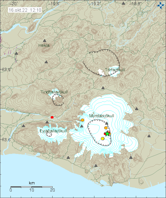
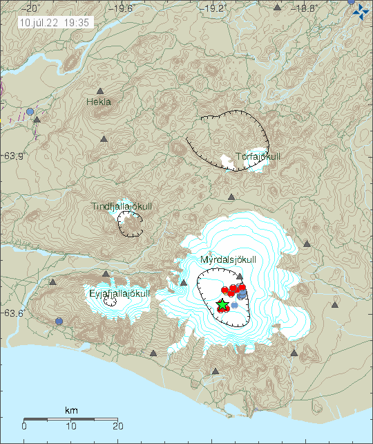
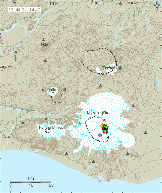
The police and Icelandic Met Office have now advised people not to go to Mýrdalsjökull glacier. This is after the earthquake swarm earlier today. According to Icelandic Met Office this earthquake swarm is similar to what happened before the minor eruption in Katla volcano in July 2011 that resulted in a glacier flood down Mýrdalssand and destroyed the bridge over the glacier river in that area. All trips to see ice caves in Mýrdalsjökull glacier have been temporarily forbidden by the Icelandic Police.

Two green stars and few red dots in Katla volcano caldera on the east side of the volcano under Mýrdalsjökull glacier
Earthquake activity in Katla volcano. Copyright of this image belongs to Icelandic Met Office.

In July 2011 it took around 24 hours from the start of the earthquake activity then until something happened. If that is going to be case now I don’t know. That this activity is similar to July 2011 eruption is worrying. The eruption in July 2011 was minor and didn’t break the glacier, but it resulted in damage in that area from the glacier flood.

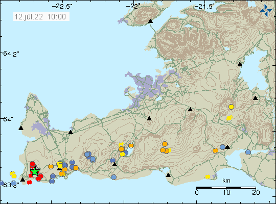
Largest earthquakes now have the magnitude of Mw3,8 and Mw3,0 (few of them). Other earthquakes have been smaller in magnitude but that might change without warning.

Earthquake swarm in Katla volcano

Today (16-October-2022) an earthquake swarm started in Katla volcano in Mýrdalsjökull glacier. Largest earthquake at the writing of this article had a magnitude of Mw3,8. I don’t know if it was felt in nearby towns and farms. Second largest earthquake had a magnitude of Mw3,0.

Green star and red dots in Katla volcano caldera that is covered with Mýrdalsjökull glacier.
Earthquake activity in Katla volcano. Copyright of this image belongs to Icelandic Met Office.

This earthquake swarm is ongoing at the writing of this article and the situation can change quickly. This might be a normal earthquake swarm and nothing more might happen. This type of earthquake swarm is not uncommon and I am not sure what is required for an eruption to start in Katla volcano.

Earthquake activity has started to increase in Fagradalsfjall and Reykjanes volcanoes

Since yesterday (06-October-2022) the earthquake activity has been increasing in the volcanoes Fagradalsfjall and Reykjanes volcanoes. Please note that Global Volcanism Program has updated the informations regarding Fagradalsfjall mountain and now classifies it as its own volcano, this is after a new report and information from Icelandic Met Office. From now on I am going to use that classification when updating on activity in Fagradalsfjall volcano. I’ll not update older articles (too much work), but this also applies to them as such.

This also means that Fagradalsfjall is a new volcano in Iceland.

Earthquake activity in Fagradalsfjall volcano, Krýsuvík-Trölladyngja and Reykjanes volcano. Shown with red, orange and blue dots
Earthquake activity in Fagradalsfjall volcano and Reykjanes volcano along with Krýsuvík-Trölladyngja volcano. Copyright of this image belongs to Icelandic Met Office.

Earthquake activity at start of an eruption cycle in Fagraldsfjall volcano are not large. They grow larger once magma has started to push into the crust, until then the earthquake activity only seems to happens with minor earthquake swarms.

Article updated with new information.

Donations

Please remember to support my work with donations. This month I am really broke. Thanks for the support. 🙂

Update on 5-August-2022 on the eruption in Meradalir valley

This is a short update because not much has changed in the last 24 hours in the eruption in Meradalir valley in Fagradalsfjall mountain.

  • The eruption is now in 120 meter long eruption fissure. Currently the output of the eruption is around 18 m3/sec according to yesterday’s measurements.
  • The new lava has now flowed over the lava from last year (2021) and into eastern Meradalir. This is about 1 km distance that river of lava has flowed.  Image of that can be found here on Facebook.
  • According to chemical analyse of the magma. This is the same magma that was erupting when the eruption in the older crater stopped erupting in September. This shows that this magma is older and the new magma has not yet reached the surface.
  • Fissures on the ground north-east of the eruption site have started to move and getting wider according to experts that are in the area. This strongly suggests that an eruption is about to happen soon in that location. When it starts is impossible to know. But this is going to close one way to the eruption and if eruption starts in new location south of the crater, seeing and viewing this eruption might start to get difficult or impossible, at least the part in Meradalir were the current eruption is happening now.

I think that is all for this Friday. Next update is going to be on Friday 12-August unless something major happens in this eruption and that might just happen.

Donations

Please remember to support my work with donations. Thanks for the support. 🙂

Update on 1-August-2022 on the earthquake swarm in Fagradalsfjall mountain

This is a short update on the earthquake swarm in Fagradalsfjall mountain and nearby area. This is written on 1-August-2022 at 13:47 UTC.

The situation on Reykjanes peninsula is always updating so information in this article can be in part or in whole get obsolete quickly. Largest earthquake during the night had a magnitude of Mw4,7. This might not be the largest earthquake today, since larger earthquakes are always a possibility.

A lot of green stars on Reykjanes peninsula along with red dots that show the heavy earthquake activity that is now happening there
Strong earthquake activity on Reykjanes peninsula. Copyright of this image belongs to Icelandic Met Office.
Time trace of the strong earthquake activity in the last 48 hours. Dark blue dots, blue dots, yellow dots with a magnitude 5,4 earthquake line in it, orange dots and red dots show all the earthquakes. This earthquake activity is really dense
Time trace of the earthquake activity in the last 48 hours. Copyright of this image belongs to Icelandic Met Office.

GPS data have started to show a large displacement over the last 48 hours. The 24 hour GPS displacement can be found here and 8 hour GPS displacement data can be found here (find Reykjanes peninsula). This shows that magma is pushing its way though the crust at fast speed, but has not yet broken up trough the crust. When that happens is impossible to know, but this might not be a long wait based on the speed the magma is going. Current depth of the magma is around 2 to 4 km.

Earthquake swarm in Reykjanes volcano

This morning (12-July-2022) an earthquake swarm took place in Reykjanes volcano. This earthquake swarm has at the writing of this article around 30 earthquakes. Two largest earthquakes had a magnitude of Mw3,3 and Mw3,4. The second earthquake was felt in towns on Reykjanes peninsula.

Two green stars on the earthquake map from 10:00 clock this morning. Along with few red dots around the largest earthquakes
Earthquake swarm on the Reykjanes peninsula in the Reykjanes volcano. Copyright of this image belongs to Icelandic Met Office.

It has been rather quiet on the Reykjanes peninsula in last few months. There is always minor earthquake activity happening because of inflation of magma in this area. There has been lack of large earthquakes in recent months. I don’t know why that is. GPS data show that there has not been any notable inflation or deflation in Reykjanes volcano for the last few weeks. That translates into lack of earthquakes. If this earthquake swarm means that is changing is something to watch out for. Small earthquake swarm can mean change, what it means here is unclear. It is known that not every eruption starts with a big earthquake swarm in a volcano.

Donations

Please remember to support my work. Thanks for the support. 🙂

Increase in earthquake activity in Katla volcano

Today (10-July-2022), earthquake activity in Katla volcano increased. Most of the earthquakes that have happened are above magnitude Mw2,0 and that is unusual. Largest earthquake at the writing of this article had a magnitude of Mw3,0.

Red dots and a green star in Katla volcano caldera on Icelandic Met Office map
The earthquake activity in Katla volcano. Copyright of this image belongs to Icelandic Met Office.

It is unclear at the writing of this article what this means. Glacier flood from Mýrdalsjökull glacier following this earthquake activity is a possibility. Currently there are no signs that an eruption is about to start, that can change without warning. This might also just be normal summer activity in Katla volcano. At the writing of this article, the answer of what is going on is not clear.

Donations

Please remember to support my work with donations. They help me a lot. Thanks for the support. 🙂

Earthquake swarm close to Geirfugladrangur on Reykjanes Ridge

On Monday (4-July-2022) an earthquake swarm started close to Geirfugladrangur on Reykjanes ridge. Largest earthquake on Monday had a magnitude of Mw3,2 and on Tuesday a magnitude Mw3,1 earthquake took place.

Green star on the Reykjanes ridge out in the ocean. Showing the centre of the earthquake activity
Earthquake activity on the Reykjanes ridge. Copyright of this image belongs to Icelandic Met Office.

This earthquake activity is what seems to be increase in earthquake activity overall on Reykjanes peninsula and on the Reykjanes ridge. The ocean is deep at this location and an eruption would have to be a big one to break up to the ocean surface because of depth in the area. I don’t know how many earthquakes have happened in this area, because of more activity on Reykjanes peninsula in last few days.

Earthquake recordings

Because of how old my hardware is and difficulty keeping it running. I have for now stopped recording earthquakes. This is going to be the situation until I can get new hardware. When that happens I don’t know. Raspberry Shake has few stations in Iceland. They can be viewed here. This is the hardware I am going to be using once I can afford to buy it. When that happens I don’t know.

Donations

Please remember to support my work with donations. I am currently really broke, because moving is expensive and I had to pay a lot of bills in July. Thanks for the support. 🙂

Ongoing earthquake swarm north of Grindavík town wakes up people

Today (22-May-2022) at 09:53 and 09:57 UTC earthquakes with magnitude of Mw3,5 and Mw3,6 took place north-west of Grindavík town. This earthquake was felt and did wake up people according to the news.

Two green stars north-west of Grindavík town along with a green star north of Grindavík. A lot of orange and red dots around the area showing smaller earthquakes
Earthquake activity close to Grindavík town. Copyright of this image belongs to Icelandic Met Office.

There is no signs that this earthquake activity is slowing down. It does come in waves according to Icelandic Met Office. This means that there are period of high activity with low activity between. Currently, at the writing of this article, there is a low activity period ongoing.

Donation

Please remember to support my work with donation if you can. Donations help me with this work and prevent me from going completely broke each month. Thanks for the support. 🙂

Earthquake with magnitude Mw3,6 in Grímsfjall volcano, no eruption yet

I’ve been trying to wait for information about the activity in Grímsfjall volcano. A new cauldron was discovered yesterday (05-December-2021). It is possible that an small eruption took place in the side of Grímsfjall volcano and didn’t break the glacier. It might have been a short eruption if that is what happened. Harmonic tremor data is unclear on this so I can’t give any good answer. At 06:16 UTC an earthquake with magnitude of Mw3,6 took place. I poorly recorded it my seismometer and it seems to have been a low period earthquake. Suggesting that a magma pushing up was the reason this earthquake happened.
Continue reading “Earthquake with magnitude Mw3,6 in Grímsfjall volcano, no eruption yet”