New harmonic tremor detected in Katla volcano

Earlier today there was an minor harmonic tremor in Katla volcano. It’s source was inside the Katla volcano caldera as before, it is impossible to know the exact location of the source this harmonic tremor spike. But earthquakes around that same time might give a clue about it’s origin.


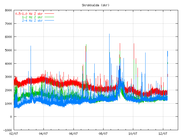
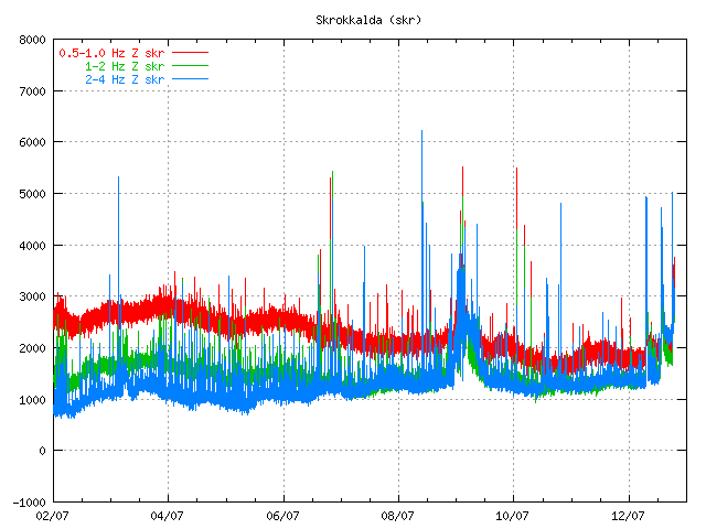
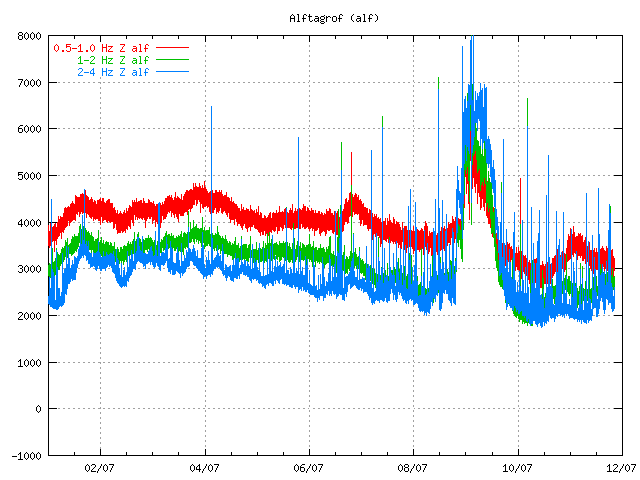
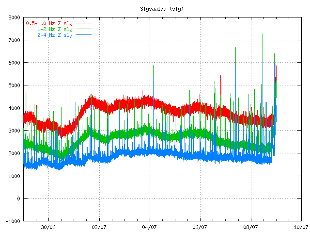
Harmonic tremor can be found close the end of this tremor chart. It is peaks from the background noise that is currently taking place in Katla volcano on this SIL station. Copyright of this picture belongs to Icelandic Met Office.


Harmonic tremor can be found close the end of this tremor chart. It is peaks from the background noise, it small but it can be found. Copyright of this picture belongs to Icelandic Met Office.


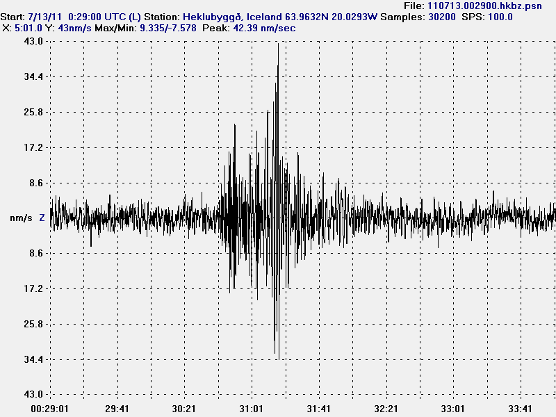
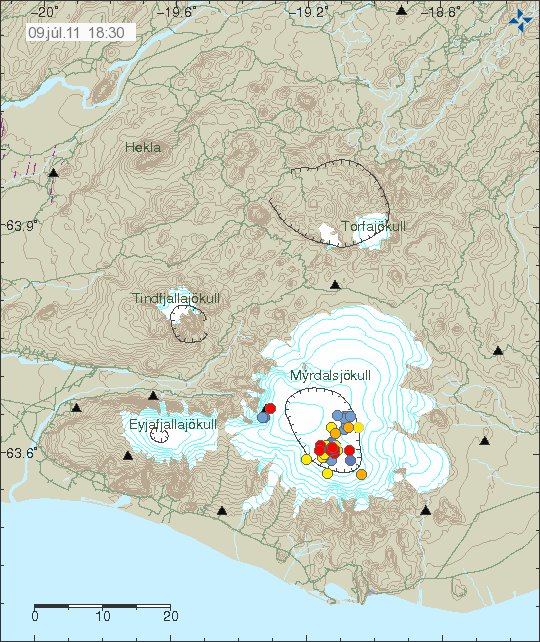
Current earthquake activity in Katla volcano caldera. Copyright of this picture belongs to Icelandic Met Office.

This harmonic tremor spike was small compared to the one on 8 – 9. July 2011. But this means that this area continues to be highly active and dangerous in my opinion. While there currently is an little pause ongoing in this area. I do not think that current events are over. When they end and how I don’t have any idea. But I am guessing that this is going to end in an full eruption of Katla volcano. When that might happen is something I don’t have any idea about.

For the moment. The only thing that can be done is to wait and see what happens in Katla volcano.

Harmonic tremor drop down. New earthquake happen in Katla volcano caldera

It seems that on many SIL station around Katla volcano that the harmonic tremor has gone mostly down to background levels, on other stations it continues to drop. This are mostly SIL stations that are at the most distance to the source of the area that this minor eruption took place during the night. But at the moment this seems to be over. The main source of the activity appears to be where the eruption took place in the year 1918, or so scientists think at the moment.

According to the news there was an flood wave around 04:00 UTC during the night. When the water meters did show an rise of 5 meters suddenly. Soon after that the bridge over Múlakvísl river was lost in the glacier flood. This did close the main road 1 in this area, that area of the main road is going to remain closed for the next few weeks while they fix the damage done in the flood (build an new bridge).

Even if the harmonic tremor seems to be dropping. This does not seem to be over, as an earthquake activity did resume from around 13:00 UTC in the Katla. Since then the earthquake activity seems to have been building at slow rate.


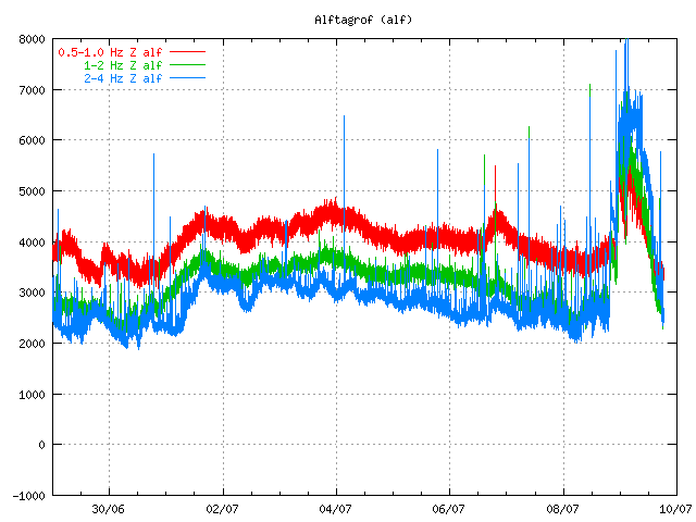
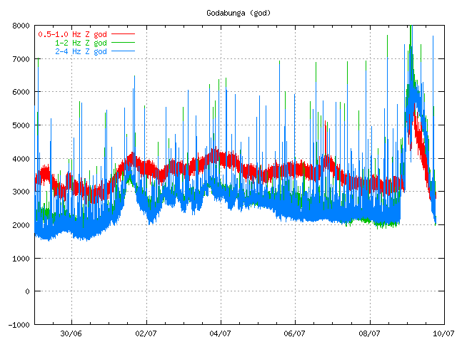
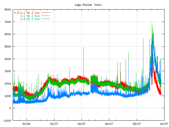
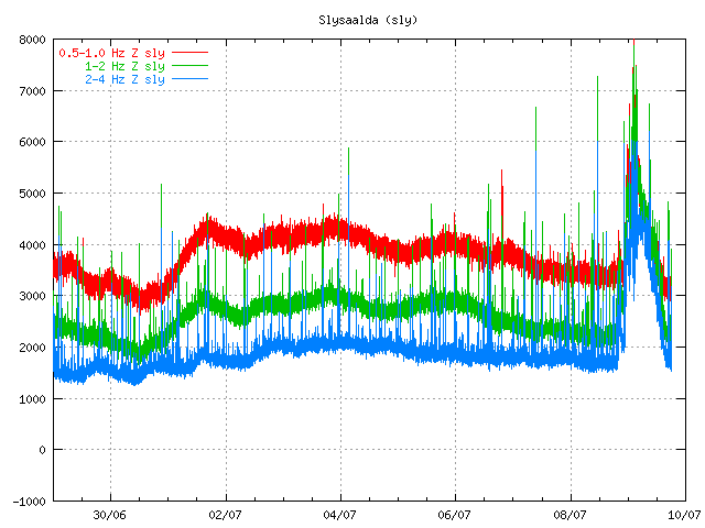
Tremor plot at 18:23 UTC. The tremor is dropping. It also shows that earthquakes are taking place (spikes the tremor chart). Copyright of this picture belongs to the Icelandic Met Office.


Tremor chart from Goðabunga at 18:24 UTC. Copyright of this picture belongs to the Icelandic Met Office.


Dropping harmonic tremor on Lágu Hvolar. Earthquakes appear as spikes here. Copyright of this picture belongs to Icelandic Met Office.


Dropping tremor and earthquakes as before. Copyright of this picture belongs to Icelandic Met Office.


Earthquakes as they are tonight. The southern part of the caldera is having earthquake swarm, even if it is just an small one. Copyright of this picture belongs to Icelandic Met Office.

I am waiting too see how this develops. Something larger might happen. But nothing else might happen for an while in Katla volcano. The only thing that can be done is too wait and see what happens in Katla volcano.

Icelandic News about the road damage.

Meiri skemmdir en talið var (Rúv.is, Picture, Icelandic)

Glacier flood from Múlakvísl has been confirmed

According to the Icelandic news an glacier flood started around midnight in Múlakvísl (link should work, let me know if it doesn’t) glacier river that runs from Mýrdalsjökull glacier. Last time this type of event did happen was in the year 1955, when an minor eruption is believed to have taken place under the Mýrdalsjökull glacier. I do not know if that is the case now. As this might just be hydrothermal water being released due to increased activity in hydrothermal areas that are in Mýrdalsjökull glacier.

Following the flood there is an strong smell of sulphur and there might be dangerous gases in it. At current time the flood appears to be growing and according to the news (written at 01:54 UTC) the bridge was still safe. But there was just 1 meter from the river and up to the floor of the bridge.

Some minor earthquakes have been taking place in the past few hours, they do not appear on the automatic earthquake list on Icelandic Met Office web page. Some of them appear on my Hekla webicorder.

Currently the harmonic tremor is dropping. But that might not mean anything in the long run. So far everything suggests that an eruption has not yet started in Katla volcano. But given the current status that might not last long as it is. The best thing that can be done is to wait and see what happens. But no fear scaremongering please!

Added: When I just finished writing this blog post an new earthquake just started to appear on my geophone at Hekla volcano. IT is from Katla volcano for sure. It was in the ML1.5 to ML2.5 size range it seems. It was an long period earthquake as they have been so far. I think it is from the main caldera, not Goðabunga area.

Icelandic News about the glacier flood.

Hlaup hafið í Múlakvísl (mbl.is, Icelandic)

Harmonic tremor continue to increase in Katla volcano

When this is written around 00:36 UTC on 9. July 2011 the harmonic tremor levels on SIL stations around Katla volcano have continued to increase. The latest spike in harmonic tremor levels happened after an ML1.5 (automatic size) earthquake that took place at 22:13 UTC. There has been an small earthquake swarm in Katla volcano caldera yesterday. But the largest earthquake in that earthquake swarm had the size ML2.4.

The harmonic levels are getting so strong that they have started to appear on stations around Hekla and on my own geophone, even if it is located almost 60 km away from the source of the harmonic tremor. Currently there is little to suggests that this is slowing down at the moment. But that might yet happen. But it is impossible to know for sure at the moment.

The lack of earthquakes tells me that the magma has not yet reached the surface. When or if that might happen is an good question that I do not have the answer to. But this might take several more hours until something happens in terms of earthquakes or other activity in Katla volcano.


Harmonic tremor can clearly be seen on this SIL station at the end of the tremor chart. This is saved around 00:36 UTC 9. July 2011. Copyright of this picture belongs to Icelandic Met Office.


Harmonic tremor can clearly be seen on this SIL station at the end of the tremor chart. This is saved around 00:36 UTC 9. July 2011. Copyright of this picture belongs to Icelandic Met Office.

As sad before the harmonic tremor can now be seen on SIL stations far away from Katla volcano. But the maximum range so far is around 65 km or so at the moment.

This is the last update for tonight. I am going post an update tomorrow on what has happened during the night. Even just to say people that things have slowed down or gone back to normal. Whatever happens. I am going to post information about it tomorrow when I awake up.

Harmonic tremor in Katla volcano

At the moment there is an ongoing harmonic tremor going on in Katla volcano. It is just an small one, just above the background level noise floor. This is most likely an small dike intrusion. But nothing in the data from Icelandic Met Office suggests that an eruption has started in Katla volcano at this stage. But that might change without an warning, since this is an volcano after all. This change in harmonic tremor does not seems to be created by an glacier flood of some type. What is interesting is that this harmonic tremor pulse looks like an harmonic tremor pulse detected in the year 1999, just before an small eruption took place in Katla volcano southern caldera rim.

This harmonic tremor is in the high frequency range at the moment. But no change has been seen in the low frequency range at the moment. This is the same thing that did happen in the year 1999. At the moment however it is too early to know what is going to happen in Katla volcano for sure. All that can be done is to watch and wait. This might quiet down, or it might not. Only time is going to tell us what happens next. At the moment the harmonic is falling at fast rate, so this might be over.

Before the harmonic tremor pulse there was an earthquake swarm in Katla volcano caldera. The largest earthquake was ML2.1 and that was an long period event, but that tells me that magma was the source of this earthquakes in Katla volcano caldera. There where two earthquake swarms in the caldera today, but that makes total of three earthquake swarms in the Katla volcano caldera since the beginning of June.


The two earthquake swarms that took place in Katla volcano caldera today. Copyright of this picture belongs to Icelandic Met Office.
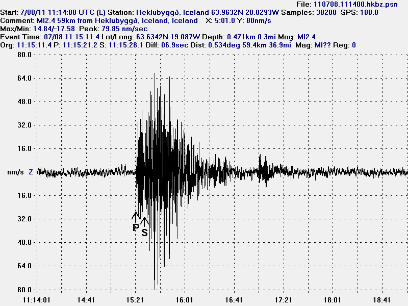

The only earthquake that I did record out of this earthquake swarm. This earthquake was ML2.40 with the depth of ~400 meters. This plot is filtered at 1Hz . This picture is released under Creative Common licence. See Licence web page for more detail.


Spectrogram of the ML2.4 earthquake in Katla volcano from this morning. This is filtered from 1Hz. This picture is released under Creative Common licence. See Licence web page for more detail.
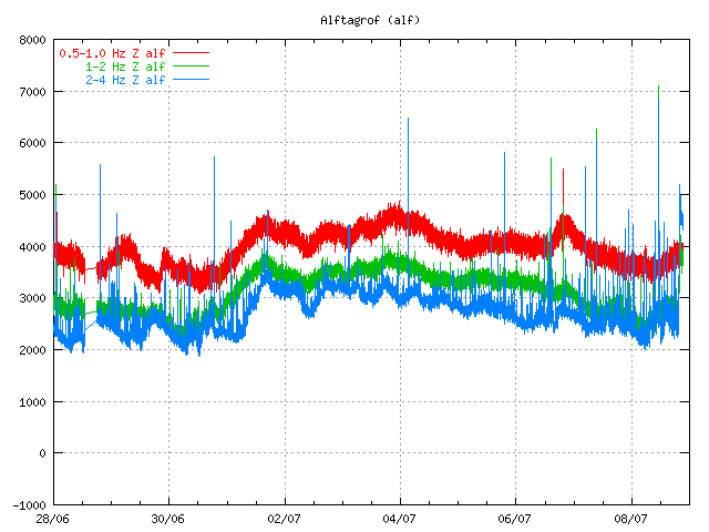

Harmonic tremor can clearly be seen at the end of this tremor chart from the Icelandic Met Office. Copyright of this picture belongs to Icelandic Met Office.
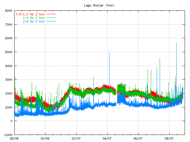

Harmonic tremor can be seen at the end of this tremor chart from the Icelandic Met Office, but it is not clear at this SIL station. Copyright of this picture belongs to Icelandic Met Office.
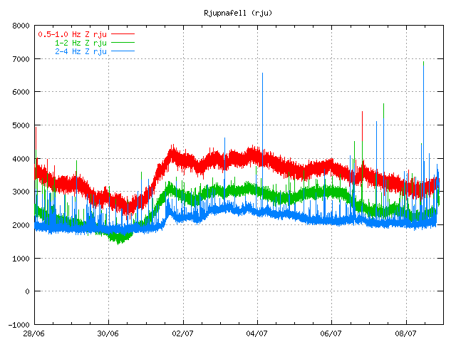

Harmonic tremor can clearly be seen at the end of this tremor chart from the Icelandic Met Office. Copyright of this picture belongs to Icelandic Met Office.
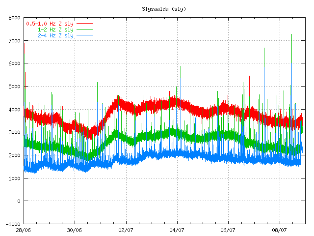

Harmonic tremor can clearly be seen at the end of this tremor chart from the Icelandic Met Office. Copyright of this picture belongs to Icelandic Met Office.
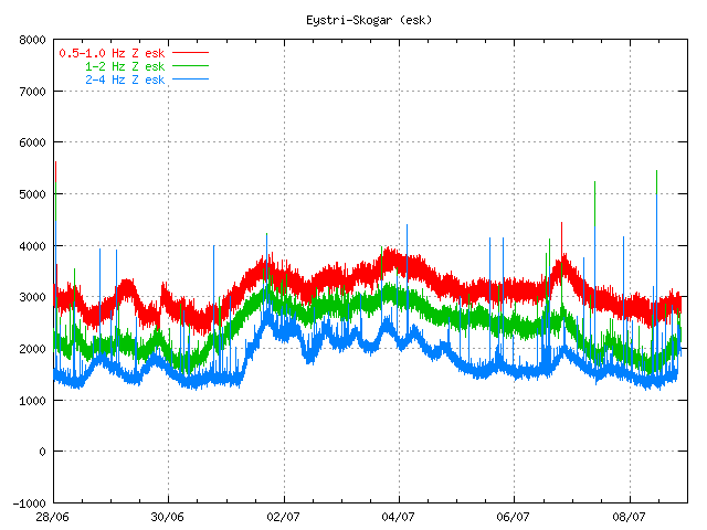

Harmonic tremor can be seen (not clearly) at the end of this tremor chart from the Icelandic Met Office. Copyright of this picture belongs to Icelandic Met Office.
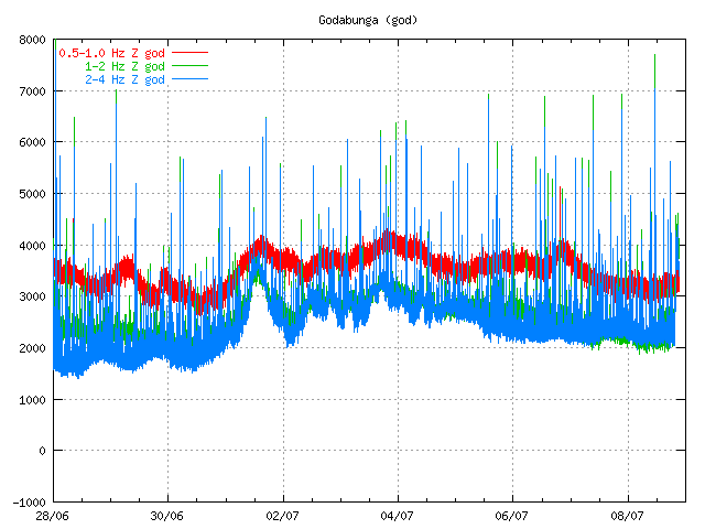

Harmonic tremor can clearly be seen at the end of this tremor chart from the Icelandic Met Office. Copyright of this picture belongs to Icelandic Met Office.

The harmonic tremor is strong enough on many SIL station to go above the background noise level on the SIL stations (wind, ocean waves etc..). But this is not an strong harmonic tremor. They can be stronger.

This does NOT mean an eruption is imminent in Katla volcano. What this does mean that is an magma is on the move inside the Katla volcano. What happens at later time is something that nobody can guess at current time. But it is now time to watch Katla volcano even closer.

It is also important to notice that nobody really knows how Katla volcano behaves before an eruption. We only get those answers after an eruption in Katla volcano. For the moment we can only wait and see what happens in Katla volcano.

I am going to post more updates if anything interesting happens. Also, there seems to have been an Long period earthquake at 22:14 UTC, most likely in Katla volcano. It appeared on my geophone close to Hekla volcano. I am guessing the size of this earthquake is ML2.0+.

Blog post updated at 22:39 UTC. Spectrogram picture added.

New harmonic tremor spike in Katla volcano

Today around 16:00 UTC there was an new harmonic tremor in Katla volcano. This harmonic tremor has two sources. Hyrdothermal activity under the glacier, or magma moving deep inside Katla volcano (without creating many earthquakes in Katla volcano). It is unclear what is the case at the moment.

This spikes are so far not related to glacier floods from Katla volcano. But that sometimes also happen without an eruption being involved.


The harmonic spike can be seen here. Close the end of the chart. It is different then the background noise as it is more powerful then the background noise. Copyright of this picture belongs to Icelandic Met Office.

It is impossible to know what happens next. But it is also important to be aware of the fact that earthquake season is starting in Katla volcano. But that is normally from end of June to beginning of October (or when it starts to snow again in Iceland). So more earthquakes are going to be seen this summer also because of more SIL seismometers around Katla volcano.

So there is no reason to panic about Katla volcano at current time. But it is worth to keep watch on it anyway.

Notice: Updates might be an little few due the fact that I am now working all day during the week and I am tired in the end of the day with no energy to write new blog posts. But I am going to do my best anyway.

Harmonic tremor pulse in Katla volcano

There appears to be an harmonic tremor pulse going on in Katla volcano. While I currently do not think that this is going to start an eruption. It is worth watching this harmonic tremor pulse in Katla. But in the year 1999 this type of activity did result in minor eruption in Katla volcano on the 17. July that year (it is believed).


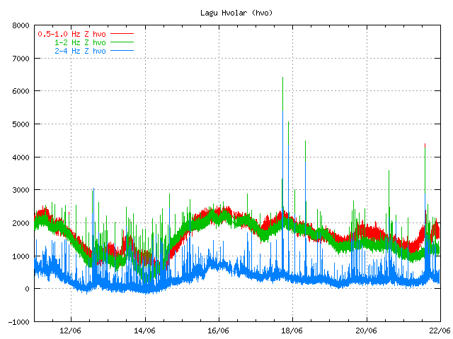
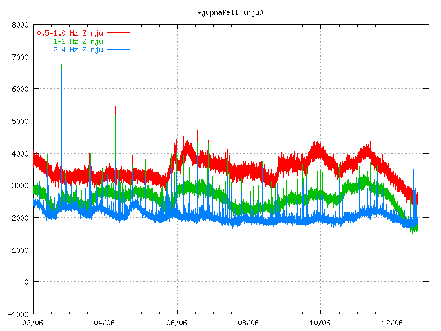
Harmonic tremor pulse can be seen on the SIL station Lágu Hvolar. Copyright of this picture belongs to Icelandic Met Office.


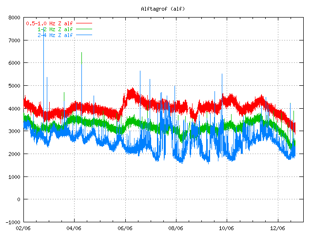
Harmonic tremor pulse can be seen on this SIL station Álftagröf. But it is hard too see it then on Lágu Hvolar. But that suggests that this tremor pulse is in fact quote weak one. Copyright of this picture belongs to Icelandic Met Office.


Harmonic tremor pulse can be seen on this SIL Rjúpnafell. It is more stronger signal then on Álftagröf, so it suggest that the source of this tremor pulse is closer to this station then on Álftagröf. Copyright of this picture belongs to Icelandic Met Office.

All pictures are from 16:28 UTC on 12. June 2011.

On other station around Katla volcano I do not see this harmonic tremor pulse on the Icelandic Met Office on-line tremor chart. But that does not mean that it this tremor pulse is not being detected on other SIL stations around Katla volcano.

The source of this tremor pulse is most likely an dike intrusion at great depth inside Katla volcano that is taking place without any earthquake activity. This has happened before without resulting in an eruption from Katla volcano (besides the event in the year 1999). I do not think that this means an eruption is going to happen soon. But this might signal that Katla volcano is about enter an more activity phase then in last few decades. But if that is going to turn out that way is something that only time can answer.

Eruption in Grímsfjall volcano is over

According to the news at mbl.is the eruption in Grímsfjall volcano did end at 07:00 UTC on the 28. May 2011. But that was when the last harmonic tremor was seen on Icelandic Met Office SIL stations.

There is an lot of volcano as in the area around Grímsfjall volcano. That means it is going to blow easy with the wind in the dry summer.

According to GPS data from Icelandic Met Office. It seems that inflation has started at Grímsfjall volcano again. But it can be assumed that it is going to take several years until next eruption. But if that is going happen we just have too see.

Morgunblaðið news about the end of the eruption.

Goslokin sett klukkan 7 á laugardag (mbl.is, Icelandic)
Grímsvatnagosinu lokið (mbl.is, Icelandic)
Gosinu lokið (Rúv.is, Icelandic)

Grímsvöt eruption appears to be over

Given the current tremor plot on Icelandic Met Office and with reports it seems that the eruption in Grímsvötn (Grímsfjall volcano) is about to be over for now. It is impossible to know if the eruption is going to resume soon or not. But at the moment this eruption seems to be over as it looks now. If it remains like that has to be seen however.

This drop in the eruption has been confirmed by Icelandic Met Office tremor plots.

Tremor plots as of 07:00 UTC. This tremor plots are from Icelandic Met Office web site. Copyright of this pictures belongs to Icelandic Met Office.

Early news this morning in Iceland reported that steam was only coming from the main crater of Grímsvötn.

Other interesting development is that an earthquakes have started to appear SSE of Grímsfjall volcano (Grímsvötn). It is unclear why earthquake are happening at this location. But dike intrusion at this location is not impossible.

The reason for flight problems in Europe is because of the volcano ash that was ejected into atmosphere in the first days of the eruption. It is going take few days for that volcano ash to disappear from the air. Until that happens, it is going to create problems for air traffic.

Update 1: Even if the eruption appears to be over the tremor is still high. I do not know why that is. It is a question why that is or if this is just break in the eruption or not. Only time is going to tell what happens next.

Update 2: There was an news report this morning that before 02:00 UTC there was an spike in activity in Grímsvötn that did shoot the ash cloud up to 8 km. But that spike did only last for few moments before it was over. Rúv has released video here (Windows Media Player) of the eruption site.

Updated at 07:37 UTC.
Updated at 07:50 UTC.
Updated at 08:33 UTC. Blog post title updated.
Updated at 11:42 UTC.
Updated at 12:23 UTC.

General overview of Grímsvötn eruption on 23. May 2011 at 20:33 UTC

This is a general overview of Grímsvötn eruption on 23. May 2011 at 20:33 UTC.

Ash cloud: The ash cloud is still going strong. It is however a bit lower then in first few days. Measurements of the ash plume now says that it is between 5 to 9 km. Because of that it does not appear on the radar at IMO. The ash cloud has now been detected all over Iceland, except for the most western part of Iceland (Westfjod). In the areas closest to the main ash cloud the visibility is from 1 meter and up to 500 meters when it is at it’s best. Ash fall is expected to last for the next few days, or until the crater does not get any water into it to make the ash. The ash cloud is expected to reach Scotland tonight (Rúv, Icelandic). BBC News about cancelled flights due the ash cloud. Farmers live stock has started to die due to the ash cloud. It is unknown how the wild life is doing while the ash cloud covers part of south Iceland. Current output of the Grímsfjall volcano is about 1000 to 2000 tons of ash pr second. It was around 10,000 tons of ash pr second during the first days of the eruption.

Rúv News, Öskufall næstu daga (Icelandic, Rúv.is)

Eruption: Even if the ash cloud is lower now. It appears that the eruption is still going strong. In the evening news at Rúv it was reported that there was a chance the magma that powers this eruption might be from a great depth (more then 20 km). Tremor graphs that are online show and suggest that the eruption is still at full power. The reason why they are at lower noise level is most likely due to fewer explosion in the eruption, as less water is in the crater. When water no longer goes into the crater it turns into lava eruption. There is also an speculation that new fissures might open up in this eruption where there is more glacier cover (evening news on Rúv). But that would mean flash glacier flood and new ash cloud when the eruption would break the glacier covering it. But so far this has not happened and is nothing but a speculation. It would mean earthquake activity when the magma would break the crust, as happened when the eruption did start on 21. May 2011.

GPS data: According to report from IMO and University of Iceland the deflation now has been 50 cm to northwest and has subsided 25 cm. According to the report this about 60% larger then after the eruptions in the year 1998 and in the year 2004.

Web cameras: Grímsvötn Míla web cam is now up and running. It should be possible to see the eruption when an ash cloud is not in the way. But so far that has been the case.

Please note that information here might get outdated really fast and with no warning at all!

Updated at 20:42 UTC.