Geophone network computer update complete

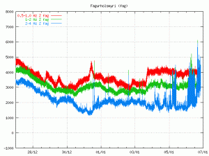
I have finished updating the geophone network computer. Everything is now back to normal and the webicorders should now update normally.

There are minor issues remaining on my geophone network computer. But that is related to lack of hard disk space. That issue is going to be fixed on later date.

Upgrade to the geophone network computer

I am going to perform a system upgrade to the Geophone network computer tonight. This upgrade is simple. I am moving from Windows 2000 to Windows XP. This update should not take any longer then 2 to 5 hours if I am lucky.

Let’s just hope that there is no big earthquake activity while this upgrade takes place. As everything is going to be off-line while this update takes place.

A magma related earthquake at Hamarinn volcano

The earthquake that happened this morning at Hamarinn volcano appears to have magma signature in it based on what I see in my own wave data. The size of this earthquake was ML3.5 according to automatic SIL data. The automatic depth of this earthquake is 1.1 km. This data is a subject to a review by Icelandic Met Office.

So far this has been a single event and no aftershocks or other earthquakes have happened in Hamarinn volcano. That might however change. But sometimes large earthquake swarms take place in Hamarinn volcano. But this volcano is known for a lot of earthquake activity at times.

There are no indications of a eruption starting in Hamarinn volcano.

Other earthquake activity

The earthquake at Hamarinn volcano appears to have started a earthquake swarm in Herðurbreiðartögl. But the area must have been at breaking point anyway and the earthquake that happened in Hamarinn volcano might have just acted as a trigger.

There have been earthquake not far from Kolbeinsey island volcano. The strongest earthquake got ML3.3 by the automatic data by the SIL system. But due to the distance this is a underestimate in size of the earthquakes taken place at Kolbeinsey island volcano. I am not sure if the earthquake swarm that was taking place there has stopped or not, as small earthquakes are not detected by the IMO SIL Network.

Quiet time in earthquakes around and in Iceland

Currently there is a quiet time taking place in Iceland. This sometimes happens. It does not mean that all activity has stopped. But it just means that the most of the earthquakes that are taking place are so called microearthquakes and that they are less then ML3.0 in size. But the thing about microearthquakes is that they are not useless, as this (pdf, English) report from Icelandic Met Office shows.

While it is quiet as it is I am going to relax a little. So that I can take on the busy times better.

Continued earthquake activity under Blöndulón and in Esjufjöll volcano

It appears that the earthquake activity at Blöndulón and in Esjufjöll volcano has not stopped completely. The earthquake activity at Esjufjöll volcano started on the 20th of October 2010. The first week there where about 70 earthquakes recorded by Icelandic Met Office, the following week there was continued activity but there where fewer earthquakes taking place in Esjufjöll volcano at that time. But the activity had not stopped completely. When this is written there are clues that there is a new earthquake swarm about to start in Esjufjöll volcano. I must point out that so far the earthquake swarms in Esjufjöll volcano have started out slow before they pick up the in size and numbers of earthquakes.

The earthquake activity under Blöndulón lake (man made lake) continues. The earthquake activity is intermittent since it started. But the largest earthquakes that have happened under Blöndulóni lake have reached ML3.8 in size. But the largest earthquakes where felt in nearby farms (up to 80 km away far as I understand). It seems that the earthquake activity continues at this location. But with long stops in-between each earthquake swarm. I do expect the earthquake activity to continue there for coming months. But sometimes it happens that earthquake swarms in the areas outside the main faults take a long time to finish. The longest earthquake swarm that I know of lasted for almost two months. This earthquake swarm at Blöndulón lake might well do something like that. But only time is going to tell us what is going to happen in that area.

Advertisement is now live on the blog site

As you may have noticed. I have placed two ads from Amazon (as Google Adsense was not working) UK on my web site. I try to have ads as low key as I can have them. I am going to add Google Adsense ads to the blog when it starts working.

Next weekend I am going to add ads to my webicorder web site. I am going to use the same low key approach as I do here. I do hope that the ads don’t bother people. As I know that annoying ads sometimes drive away people from reading blogs and even big web sites. I do want to prevent that from happening to my blog and web site.

Thanks for the support.

Are Esjufjöll volcano starting to inflate ?

I have been monitoring the GPS station at Grímsfjall volcano. After the earthquakes that took place in Esjufjöll volcano few weeks ago something interesting started to happen at that GPS station. It started to move in north direction.

Due to the location and lack of activity in Esjufjöll volcano there are almost none GPS stations around that volcano, and there are not many SIL station in this area. So getting insight into what is happening in Esjufjöll volcano is hard. But given the GPS station at Grímsfjall volcano it seems to that Esjufjöll volcano have started to inflate. It is hard to know exactly by how much at current time. But it appears to enough to have effect on the GPS station at Grímsfjall volcano.

This is given that Grímsfjall volcano it self is not having any inflation south of the GPS station on it’s own. At the moment it is hard to know what volcano is responsible for the northward movement. Only time is going to tell us the truth in that matter.

Grímsfjall volcano GPS data (automatic, Icelandic)

Earthquakes in eastern part of Katla volcano (Mýrdalsjökull)

Last week something interesting started to happen in Katla volcano last week (Week 45). Earthquakes started to appear in the eastern part of the Katla volcano. This is higly unusual and is not the normal earthquake zone in Katla volcano. But normally the earthquakes take place in the western part of the Katla volcano (Goðabungu area) and few earthquakes take place in the caldera it self at regularly.

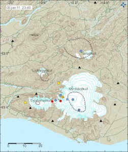
At 00:45 UTC there was a earthquake in eastern Katla volcano, the automatic SIL size of this earthquake was ML2,5 at the depth of 1,1Km (with a good quality of 90,05). Both figures are subject to a revision by a seismologist at later time, so both size and depth can change. I did manage to record this earthquake on my Hekla geophone, even if there currently is rather high wind noise at my geophone. What I did see on my geophone is interesting. But the earthquake appears to have low frequency component in it, even if it is mostly high-frequency type of earthquake. But those earthquakes are normally created by a fault in the crust, not by magma movement.

I need more data to confirm it. But there are clues that the earthquakes in eastern Katla volcano are due to magma movement, rather then tension changes in the crust not related to magma movement. What is happening there is unclear at the moment, as GPS stations around Katla volcano do not show anything interesting at the moment.

No eruption is imminent in Katla volcano at current time.

Tröllaskagi and a extinct volcano

Here are pictures of Tröllaskagi from a town called Sauðárkrókur.

Tröllaskagi to the north from Sauðárkrókur. Click on the picture for larger resolution.

Tröllaskagi to the east from Sauðárkrókur. Click on the picture for larger resolution.

Tröllaskagi to the south from Sauðárkrókur. Click on the picture for larger resolution.

Tröllaskagi is a really mountainous region of Iceland. Few people live there. But there are some farms in few of the deep wallies there. But not many to my knowledge. This area also once hosted a large glacier. But there are few remains left of it today. This area is mixed in rock. But this rock also holds a different age and origin far as I know. There are theories that this might be a old continent crust that make up Tröllaskagi.

The extinct volcano

There are more interesting things around Sauðárkrókur then just Tröllaskagi. This caldera is one of the visible features from Sauðárkrókur. The current conclusion about this caldera it is extinct. While I personally don’t agree with that and believe that it might still be active given it shape. I have no way to prove it, unless it starts to erupt all of a sudden. This is a stratovolcano with a small caldera. This volcano formation is small compared to many other Icelandic volcanoes. Both active and extinct.

A zoom in of the extinct volcano caldera. Click on the picture for higher resolution of it.

A wide angel view of the extinct volcano caldera. Click on the picture for higher resolution of it.


View Larger Map

A Google Map view of the extinct caldera from the above. It is a bit hard to see it from above.

The volcano also is on a rift zone that for some unknown reasons is not active at the moment. But a study on this rift zone can be found here (pdf) in English. I don’t know if this rift zone is going to get re-activated in the future or not. Currently there are few to none earthquakes in this rift zone.