New earthquake swarm in Herðubreið

Yesterday (14-May-2014) an earthquake swarm started in Herðubreið, after an earthquake swarm in Heruðbreiðartögl dropped in activity. Both earthquake swarms are currently active. The earthquake activity however drops between as the swarm activity picks up.

140514_1935_myvatn
The earthquake swarm in Herðubreið and Herðubreiðartögl. Copyright of this image belongs to Icelandic Meteorological Office.

Most of this earthquakes had the magnitude smaller then magnitude 2,0. There was one magnitude 2,4 earthquake in this swarm. Over 100 earthquakes where recorded during this swarm. It remains unclear what is creating this earthquake swarm. It might just be tectonic stresses in Herðubreið and nearby area, or this might be magma injection. So far there is nothing suggesting that an eruption is going to take place at this location.

Donations: Please remember to donate. I am now really, really broke and its just the middle of the month. Yes, I do hate being broke, but I don’t exactly have many options open to me at the moment when it comes to money. Thanks for the support.

Earthquake activity in Herðubreið is not volcanic in nature

The earthquake activity in Herðubreið during past few days is not volcanic in nature, or magnetic in nature. It is purely tectonic in nature. But the faults that have been moving are vertical, not horizontal as so many earthquake faults. Earthquakes are common in this area, as it on the eastern rift zone. The fault lines in this area of Iceland are highly active at times. Iceland Metorlogical Office has released this interesting information about the earthquake activity in this area during the past few years.


The first fault plane in Herðubreið. This one has the direction of N41°A. Copyright of this image belongs to Iceland Meteorological Office.


The second fault plane in Herðubreið. This second fault has the direction of N221°A (49°). Copyright of this image belongs to Iceland Meteorological Office.

Most of the earthquakes are on the depth of 5 to 6 km according to IMO.


The earthquake activity in Herðubreið the days 14 to 17 of May 2012. Copyright of this image belongs to Iceland Meteorological Office.


Earthquake activity in Herðubreið during the years 2005 to 2006. Copyright of this image belongs to Iceland Meteorological Office.


Total amount of earthquakes in Herðubreið from the years 2005 to 2012. This clearly shows that activity in this area has been rather constant during this period. Copyright of this image belongs to Iceland Meteorological Office.

The area in question is outside Askja volcano main fissure swarm. It is also outside Kverkjföll volcano main fissure swarm. So this earthquakes are tectonic in nature. But even so this area has erupted in the past. But for now. It is just earthquakes and not magma on the move, or breaking its path up to the surface as was case in Upptyppingar tuff mountain. The images are from Week 20 overview (what is up about it) at IMO web site.

Earthquake swarm continues close to Herðubreið. Earthquake activity in Katla volcano

The earthquake swarm that started in Herðubreið two days ago continues. So far over 100 earthquakes have been recorded. Most of them are less then ML2.0 in magnitude. But this earthquake swarm continues at slow rate. This is not a big earthquake swarm. Based on number (in my system) of earthquakes pr hour. But in my system, a large earthquake swarm has tens to hundreds of earthquakes pr hour.


The earthquake swarm in Herðubreið. Copyright of this image belongs to Iceland Meteorological Office.


A bit higher resolution of the earthquake swarm in Herðubreið. Copyright of this image belongs to Iceland Meteorological Office.

Katla volcano

There is some earthquake activity in Katla volcano. But it is not high. There was one small earthquake this evening (it did appear on my Skeiðflöt geophone). But it has not been reviewed. So both size and depth are going to change.


Earthquake activity in Katla volcano during the past few days and until today. Copyright of this image belongs to Iceland Meteorological Office.

The earthquake activity in Katla volcano is also showing interesting pattern during this week (Week 20). It seems that earthquake activity is focusing on one point inside the caldera. It is hard to know for sure what this means at current time. But it is my opinion that it is not a good sign. But so far, nothing major has been happening inside Katla volcano caldera at this time. Until that happens, it is just best to keep watch and keep speculations within the amount of what is going on.


Earthquake activity in Katla volcano during Week 20 (current week). Copyright of this image belongs to Iceland Meteorological Office.

Beside this activity. It has been quiet in Iceland now for several weeks now. That is not un-common to happen during some years. While other years are often more active, some years are quiet. It is not clear yet if the year 2012 is going to be quiet year in Iceland or not.

Earthquakes in Katla volcano. Earthquake swarm continues close to Herðubreið. Other earthquake activity

This morning there was a short earthquake swarm in Katla volcano caldera. This earthquake looks like a minor dike intrusion did take place this morning. Current series of events did start on 28. April 2012. With a small earthquake event and a small glacier flood that did follow it. Along with harmonic tremors coming from the glacier flood and possibly Katla volcano caldera (hydro-thermal activity boiling or something of that nature). I do not yet know if there was any glacier flood following the event this morning. But so far there is nothing that suggests a small glacier flood did take place following the earthquake swarm this morning.

The earthquake swarm this morning took place on an location that did erupt on 8 and 9th of July 2011. So it is clear the area that erupted last year is picking up activity again. But there was an drop in activity from end of November 2011 until end of April 2012.


Earthquake activity in Katla volcano this morning. Copyright of this picture belongs to Icelandic Meteorological Office.

This earthquake activity did appear well on my geophone at Skeiðflöt farm.


Earthquake activity in Katla volcano caldera this morning on my Skeiðflöt geophone. There is a lot of noise on this geophone. But earthquake activity can still be seen on this. The earthquakes are marked by red (some noise is also marked by red). This picture is released under Creative Commons Licence. See CC Licence page for more details.

It is clear that Katla volcano seems to be warming up to an eruption. But it is impossible to know when such eruption might happen, or how big it is going to be.
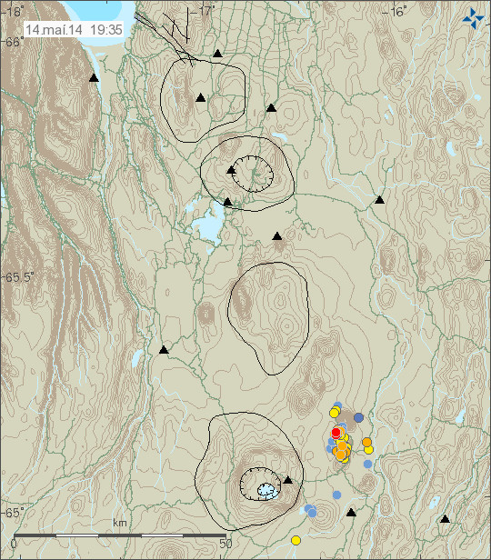
Herðubreið

Earthquake activity continues south-west of Herðubreið. But almost all of the earthquakes have been less then ML2.0 in magnitude. Earthquake activity has been slowing down all day. At the moment, it appears this earthquake swarm is close to being over.


The earthquake activity close to Herðubreið mountain. Copyright of this picture belongs to Icelandic Meteorological Office.

This area is well known for for earthquake activity. So this is not something that is new in this area.

Reykjanes Ridge

According to EMSC and USGS there have been several earthquakes with the magnitude of Mb4.5 to Mb4.8 on the Reykjanes Ridge. Earthquake activity is common on the Reykjanes Ridge. But because of the location and depth (around 2km) it is impossible to know if there any volcano eruption taking place at this location. It might well be, or not.

Kolbeinsey Island

Over the past weeks there has been some earthquake activity close to or in Kolbeinsey Island. The largest earthquakes have had the magnitude around ML3.0, with some underestimates due to distance from the SIL network. At this moment it is impossible to know if this earthquake activity is related to possible eruption activity. But it believed that an eruption (or dike intrusion) took place on Kolbeinsey Ridge in the year 1999. It started off with a large earthquake swarm.

Minor earthquake swarm close to Herðubreið

Today a small earthquake swarm started just south-west of Herðubreið. But Herðubreið is a volcano cone formation that erupted during last ice-age. But that eruption did break up trough the glacier. Explaining its shape.


The earthquake swarm off Herðubreið. Copyright of this picture belongs to Iceland Meteorological Office.

Largest earthquake so far had the size around ML3.1. But aftershocks have reached the size of ML2.5 according to IMO automatic magnitude estimate. This earthquake swarm is currently ongoing.

Icelandic news about this.

Grunnur skjálfti við Herðubreið (Vísir.is)
Jarðskjálfti nærri Herðubreið (Rúv.is)

Plus. Here are pictures from The Telegraph of Iceland volcanic nature.

Iceland from the air: aerial pictures of the country’s dramatic volcanic landscapes

Other: Donations help me running this blog (they also help me paying the bills, buy food and what comes with being a human being). Plus it appears that I need go the dentist. But as it is now. I can’t afford it properly. Thankfully this is not an emergency that I am dealing with in one of my tooth. But I need to get it fixed one way or the other soon. Thanks for the support! 🙂