This is the short update for Bárðarbunga volcano for Monday 5-January-2015.
No major change has been reported in the eruption in Holuhraun during the weekend. The eruption continues mostly in the same phase as before. The lava now mostly flows in lava tubes in the large lava field that has been created in this four month old eruption.
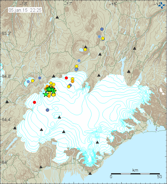
The earthquake activity in Bárðarbunga volcano for the past 48 hours. Copyright of this image belongs to Icelandic Met Office.
Earthquake activity in Bárðarbunga volcano has dropped for the past few days. It doesn’t seems to be increasing again, that suggest in my view that the magma chamber that was being emptied is now almost or completely empty. If that is the case there is a risk (in my view) that a it might collapse in on it self. That would not be a caldera collapse, rather just collapse of one chamber in a complex volcano. This might not happen, if it does the signs are going to be swarm of large earthquakes taking place during the time this happens. If this does not happen, the crust in Bárðarbunga volcano might stay (even if most or all of the magma is gone) up and not break so easily. It is however a common fact that nature does not like empty spaces where none need to be.
Tungafellsjökull and Hamarinn volcanoes
There is now a concern among that Bárðarbunga volcano is starting instability in Tungafellsjökull volcano and Hamarinn volcano (also known as Loki-Fögrufjöll). The volcanoes Grímsfjall and Kverkfjöll are at risk of increased instability due to Bárðarbunga volcano, at the moment however that does seems to be happening. The story is different with Tungafellsjökull and Hamarinn volcanoes, there is increased activity in those two volcanoes over the past four months.
There is a problem with Hamarinn volcano that it is not earthquake active volcano and it appears to be able to erupt without much warning or any earthquake activity at all (that might change, this is just what past data suggest). Suggesting that magma is already at shallow depth in it and the crust might be so soft that it doesn’t break (this is just my idea of what might be going on, it has not been proven by measurements far as I know). If that is the case, as the data suggest an eruption in Hamarinn volcano might happen without warning and little or no earthquake activity at all. Last eruption in Hamarinn volcano was in July-2011 and I did cover it here and here.
Tungafellsjökull volcano is a different story. There has been some dyke activity been taking place in it since late 2011 or early 2012. Those dykes have created pathways for larger magma intrusion into the crust. Currently that magma is not in high amount to erupt, it also does not have the pressure to erupt far as I can tell from the data (in my view). As this stands now, a considerable more has to happen in Tungafellsjökull volcano before a first ever eruption in historical times (warning! I have known to be wrong about those things).
Donations
Please remember to support my work with donations or by shopping with Amazon banners that I have up here. Thanks for the support.