The importance of good science in geology (and other fields too)

I am not going to make this a long blog post.

I know that many of you find that I have been unfair when it comes to deal with certain ideas about geology and how it works. The truth however is that this was a lot more then just a idea, or a hypothesis. The claim was that “evidence” had been found for the claim to support. But from what I did see, no evidence where provided in support of the claim. To to be fair, it was sad that this idea might be wrong and wrong it was in my opinion.

This is what I call bad science. It is something that is not going to work and is never going to. The scientific method (wiki) is well established way of proofing claims and ideas.

For instance, all that I do in terms of geology and other fields of science fall all under this process. If I fail it is a important step, because it at least gave me a result to work with. When doing science, it is important to life with the fact not everything that is done is going to work up, or even get that far before it fails so spectacular that they did notice in the next lab over.

I do not dismiss everything that I read. But I am going to dismiss it if no evidence is provided with the claim in question. I my self is working on few ideas, that I have at least started from start up around 40 to 50 times on times. Just because it failed my test and did not fit the data that was observed.

This is how progress is made. With hard work and good scientific method. What is not progress is Pseudoscience (wiki) that in fact return nothing in the short and long term. I have for too long seen this happens on the internet and I am not going to let this happen to any of my blogs that deal with science topics (including this one here. It is a slow, slow blog).

Ideas are good and all that. Just tell the world if you have any data or not when you put your idea forward.

I also want to point out this two articles here. They are not science in them self. But they might explains one or two things about why I am strict on this matter and with the comments. But I want to keep this blog clean and good for all my readers.

5 Ways to Stop Trolls From Killing the Internet (Cracked.com)
Internet Argument Techniques (Cracked.com)

Thanks for the understanding.

Few points about Iceland geology

Here are few points about geology in Iceland (just because I cannot sleep at the moment). This is also a offshoot of this blog post here.

The basic thing that needs to be known about Iceland is the fact that it is just a island over a hot spot. In every other terms it behaves as expected by a volcanic island on a rift zone. There is a lot known about Iceland geological features and volcanoes. But there is also a lot unknown at the moment. There is nothing mysterious or strange about that. We just don’t know this at the moment, but in the future we hopefully are going to know this. As each eruption or earthquake swarm teaches us more about Iceland and how it works.

I have seen a lot of wrong things about geology in Iceland on this blog in past few days. For instance the claim that energy travels trough a fault zone with N-S bearing (mostly). The volcanoes in question where Hengill volcano and Hekla volcano. This volcano do not exchange energy over SISZ. It simply just does not happen, as law of nature does not allow for it to happen. The following natural laws prohibits this energy transfer (and there is no way around it), Laws of thermodynamics, Inverse-square law, Conservation of mass, Conservation of energy, Momentum, Angular momentum and whole a lot of other physical laws that apply in nature.

I know one of two thing about physics too. As I fully apply that when I am considering what a volcano or a earthquake swarm might be up to in Iceland.

The evolution of Iceland during the past ~20 million years is also a factor in this. As there are many fully formed rift zones, but there is also a lot of failed rift zones in Iceland. There might even be new failed rift zones being formed today. But it impossible to know that for sure at given time. Since we have no way of knowing what is “new” and what is “old”. Research into this matter is going to shed some light on it. But that might take years of hard work of scientists for years to come.


The basic evolution of Iceland from 15milyr ago until the today. Copyright of this image belongs to its owner.


This is the best picture that I know of what they think is the Iceland hotspot. Copyright of this image belongs to its owner.

There is also the thing about the crust in Iceland. But it is believed that part of it might be from a old continent. But majority of it is currently covered with newer layers of rock and sediments. But studies have also suggested (or proved) this. The following papers can be read on this subject.

Older crust underlies Iceland (pdf)
Continental basement under Iceland revealed by old zircons
Continental geochemical signatures in dacites from Iceland and implications for models of early Archaean crust formation (ScienceDirect)

This in part explains the difference in crust thickness when it comes to Iceland.


The thickness of the crust in Iceland. Copyright of this image belongs to its owner.

All pictures above are from this study into the Iceland mantle plume (they are trying to disprove it existence). Iceland & the North Atlantic Igneous Province

Here is a different map of Iceland volcanoes, fissure swarms and age of the lava fields.


Iceland and its volcanoes. Copyright of this image belongs to its owner. This picture is from this web site here, Post-glacial rebound of Iceland during the Holocene Click on the picture to get full size.


Similar map. But in colour. Copyright of this image belongs to its owner.

I hope that this clear few things up about Iceland and how it works and might work. Since we are still learning and there is a lot of things that we do not know about how Iceland actually functions. But me and professional geologists and scientists are doing there best to learn about how Iceland works.

If there is a claim about Iceland that just sounds crazy, it probably is crazy and not based in any actual fact about Iceland and the geology that makes up Iceland.

Minor earthquake swarm in Öræfajökull volcano

Since early this morning there has been a minor earthquake swarm in Öræfajökull volcano. This earthquake swarm is so far just minor one, with the largest earthquake being ML2.0 at 4.3 km depth.

This earthquake swarm is most likely due to magma injection into Öræfajökull volcano. But this volcano is normally quiet and almost never has any earthquakes. But that has been changing during the past few years, but earthquake swarms have been getting more common in Öræfajökull volcano. Something that is in fact a big change from few years ago when no earthquakes where recorded from Öræfajökull volcano.

This increased activity in Öræfajökull volcano seems to be happening at the same time as there is increased activity in Esjufjöll volcano. The two volcanoes are not connected. But this might suggest a more inflow of magma under the general area. But that is just a speculation, based on rather limited amount of data.


Öræfajökull volcano is located to the south end of Vatnajökull glacier. Copyright of this image belongs to Icelandic Met Office.

The earthquakes in Öræfajökull volcano have been taking place in the main crater of the volcano. But it is important to know that currently there is nothing to suggest that a eruption is imminent in Öræfajökull volcano or in Esjufjöll volcano.

Interesting reading material on Öræfajökull volcano

The 1362 AD Öræfajökull eruption, Iceland: Petrology and geochemistry of large-volume homogeneous rhyolite (pdf)

Few right and wrong things about geology in Iceland, part 1

I have seen many speculations on how geology works in Iceland. Some of it is good and based on observation and factual basic. Other however is nothing but speculation and far from anything based on factual evidence on how geology works in Iceland.

Few right and wrong things about volcanism in Iceland

Volcano interaction Status: Limited truth to this

Volcano interaction is something of a debated among scientists. But what is not debated is the interaction between volcanoes that lies far apart. That interaction is none by it’s nature. So while I have been seeing discussion in the comments here that there is some connection between activity between Hengill volcano and Hekla volcano. This is untrue. There is no connection between those volcanoes and never has been. The reason is simple. The volcanoes are far apart. They don’t even share the same magma source. But that is evident by the lava that comes from this two volcanoes. But Hekla volcano has mixed types of eruption sometimes. But Hengill volcano only has Hawaii styles eruptions (if not hit by water) when it erupts, in style with other volcanoes on the Reykjanes ridge rift zone.

The only real life examples of volcano interaction are from Bárðarbunga volcano and Torfajökull volcano. The reason for this interaction is quite simple and logical one. Bárðarbunga fissure swarm cuts right trough Torfajökull volcano. When magma travels south-east in the fissure swarm (it last happened in the 15th century) it can hit the magma inside Torfajökull volcano. When this happens there is a big bang in Torfajökull volcano. As the magma in Torfajökull volcano seems to be colder and more Intermediate (andesitic) [link, Wikipedia] in nature. But in Bárðarbunga volcano the magma is Mafic (basaltic) in nature. When the two magmas mix, it ends with a bang and eruption in both volcanoes. But normally the process that starts this is because there is a ongoing eruption in Bárðarbunga volcano. So when Bárðarbunga volcano. I would worry about that rather then anything else.


See, no connection at all between Hekla and Hengill volcano. Copyright belongs too this picture owner. Owner unknown to me.

Iceland is going to have VEI-8 eruption. Status: Not likely.

All volcanoes can do a VEI-8. But the thing is that they are just not likely to do so. As the size of the eruption is directly connected to the inflow of magma it is getting. In the case of Icelandic volcanoes the inflow just seems to be few magnitude too small to make a VEI-8 eruption. The largest VEI eruption known in Iceland was a VEI-6 eruption that took place in Bárðarbunga volcano in the year 1477 (?).

As for VEI-8 eruption. I am not expecting that type of eruption any time soon in Iceland.

Iceland is one volcano. Status: False.

The simple answer is no. The long answer is. Iceland has many volcanoes, not just one. So the answer is no to this.

Geology in Iceland is well understood. Status: False

Geology in Iceland is understood. But far from being fully understood. As it happens geology science is just starting to now understand what complex progress are taking place in Iceland. A lot have been learned. But a lot more needs to be learned about how geology works in Iceland.

Volcano eruptions comes in active cycles. Status: True

This has been observed by actual data. But volcano activity happens in periods of 80 to 160 years. With a quiet period of 50 to 90 years. But numbers are approximation. During the quiet time there are fewer eruptions and they are smaller (hint: Large eruption can still happen however during the quiet period). Last quiet period started in around the year 1870 and did not end until the year 1983. But that year there was a eruption in Grímsfjall volcano. But then Grímsfjall volcano had not erupted since the year 1954, but that break was 29 years long for Grímsfjall volcano.

This graph here also shows this clearly. But this is volcanism in Iceland during the years 1875 and to the year 1993.


Copyright holder unknown. Copyright of this picture belongs to this owner.

It is impossible to know for sure when the high peak in the current cycle is going to be be. But most geologist are estimating that to be sometimes from the year 2020 and to 2080 or about that. So the years ahead is going to be quite busy in Iceland in the terms of volcano activity.

I am going to write more right and wrongs about Icelandic volcanoes soon. But for now this is good enough.

Sources and other things.

Volcano-tectonic Interaction in the Hengill Region, Iceland during 1993-1998 (pdf)
Volcano geodesy and magma dynamics in Iceland (ScienceDirect)
Interaction between Continental Lithosphere and the Iceland Plume—Sr-Nd-Pb Isotope Geochemistry of Tertiary Basalts, NE Greenland
Tomographic evidence for a narrow whole mantle plume below Iceland (ScienceDirect)
Pdf document on Hengill volcano crustal deformation.
Magma (Wikipedia)
Volcano geodesy and magma dynamics in Iceland (pdf)

Katla volcano earthquake last night

Last night there was a earthquake with the size ML2.3 and with the depth of 1.3 km inside the caldera of Katla volcano. This earthquake might well be just part of the normal summer and autumn earthquake activity in Katla volcano. But at the moment it is hard to know for sure the difference at the moment.


Current area of activity in Katla volcano. It is mostly inside the caldera. Copyright of this picture belongs to Icelandic Met Office.


The ML2.3 earthquake in Katla volcano caldera last night. The P and S wave markers are unset. Picture Licence is Creative Commons.


The frequency spectrum of the Katla volcano caldera earthquake. As can be seen this earthquake has a lot of low frequency in it. Picture Licence is Creative Commons.


The Katla volcano caldera earthquake as it was recorded on my Hvammstangi geophone. It is quite unusual to record this small earthquake at this distance. This is filtered at 1Hz. Picture Licence is Creative Commons.


This earthquake here is from Goðabunga this morning. But Goðabunga is part of Katla volcano. But it is yet unknown if it is a volcano system on its own or not. The earthquakes from Goðabunga are different then the earthquakes from Katla volcano caldera, as can clearly been seen on this pictures. Picture Licence is Creative Commons.

Besides this minor earthquake activity. Everything remains quiet in Katla volcano at the moment. When that is going to change is impossible to know.

Blog post updated at 21:10 UTC.

A ML3.7 (automatic size est.) earthquake happens on Reykjanes, close to town called Grindavík

A earthquake that had the automatic size of ML3.7 did happen at 22:14 UTC on the Reykjanes. This earthquake was only 2.6 km away from a town in called Grindavík. The earthquake was felt well in town according to reports that I got over Facebook.


The ML3.7 (automatic size) earthquake location. Copyright of this picture belongs to Icelandic Met Office.

So far no aftershocks have happened where the main earthquake took place. But that might change at any time.

Background noise compared to a eruption and other events

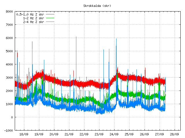
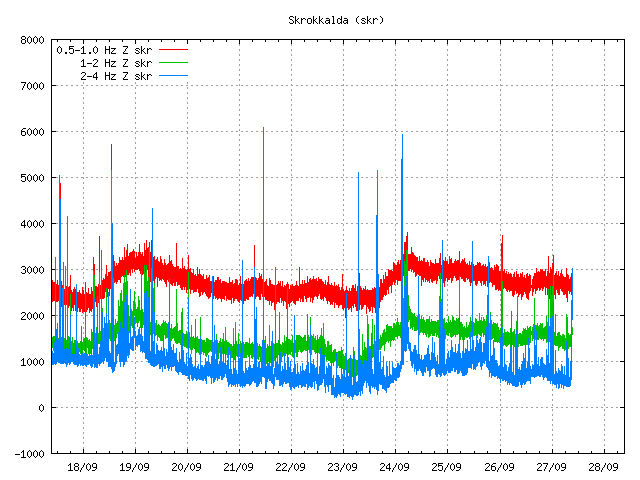
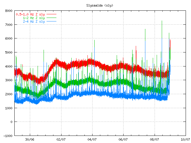
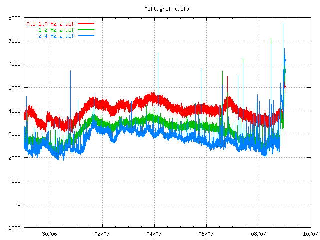
Here are few examples of how the tremor plots looks like if anything important is going on in Iceland.


Normal quiet tremor plot. Few earthquakes create spikes on it. But besides that everything is quiet. Copyright of this pictures belongs to Icelandic Met Office.


This is from the Grímsfjall volcano eruption in May 2011. On this tremor plot it can be clearly seen how much noise a eruption actually makes. The background noise just goes away soon as there is something going on. Copyright of this pictures belongs to Icelandic Met Office.


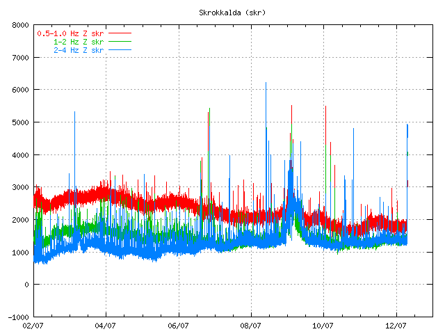
This is Skrokkalda SIL stastion on 12 July 2011. It can clearly be seen where the harmonic tremor goes above the background noise. Copyright of this pictures belongs to Icelandic Met Office.

It is quite clear. Besides earthquakes and some harmonic tremors that are different then this signals that I have shown here. Unless you see this on Icelandic Met Office tremor plot you can be sure that it is quiet in Iceland. Volcano eruptions make a lot of noise when they are ongoing, even the small eruptions make some noise that can be detected by the SIL network in Iceland.

Note: I might update this blog post on later date and put in more examples about the difference between background noise and a eruption.

New pictures of Eyjafjallajökull Gígujökull glacier lava field

Rúv News has just published new pictures of Eyjafjallajökull volcano. The pictures are from Fimmvörðuháls lava field and the lava field that is in Gígujökull glacier. But in that area a lava flow did take place during the eruption. That lava field has not been explored before. According to the news, a moss has already started to grow on the new lava on Fimmvörðuháls. The Gígjökull glacier has already started to cover the lava field that did melt it during the eruption of 2010 in Eyjafjallajökull volcano.


From Gígjökull glacier. Picture from Rúv News. Copyright holder of this picture is Rúv.

The news of this can be found here. This is in Icelandic.

News from Rúv.

Undraveröld í Gígjökli (Rúv.is, Icelandic, Picture, Video)

Earthquake swarms in Krýsuvík volcano, Tjörnes Fracture Zone and SPAR fracture zone (Kolbeinsey Ridge)

In the last few days there has been good earthquake activity in TFZ (Tjörnes Fracture Zone). The largest earthquakes have been up to ML3.0 in size. But this earthquakes swarm have mostly been small and lasted for a short time.

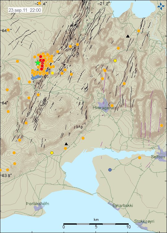
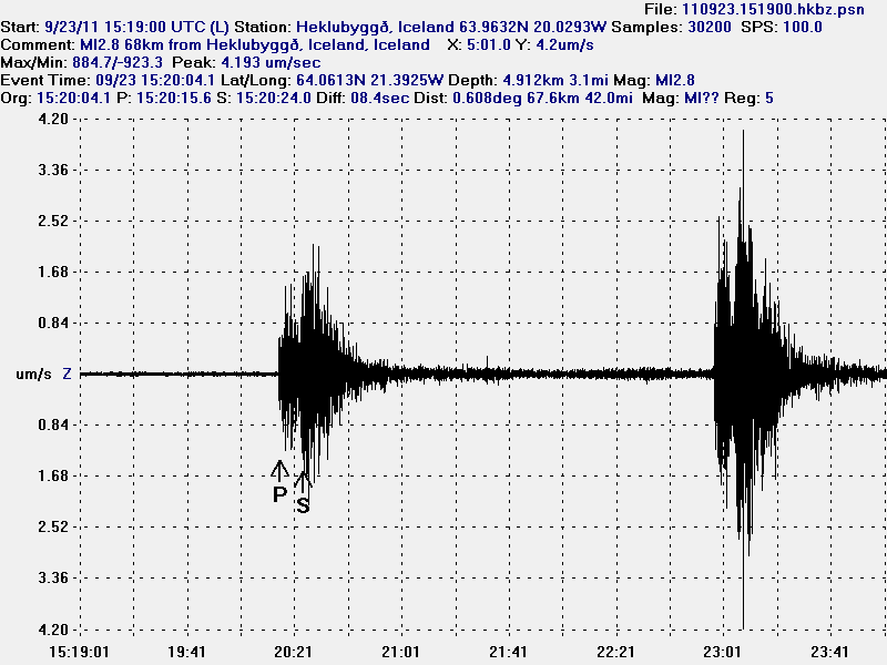
Last night a earthquake swarm started in Krýsuvík volcano. This was just a normal tectonic earthquake swarm that normally takes place in this area on regular basic. From what I can tell. But it is impossible to know if this earthquake swarm was created by magma movement or not.


The earthquake swarm as it did appear on my Heklubyggð geophone. This picture is released under Creative Common Licence, see the licence page for more details.


The location of the earthquake swarm. Copyright of this picture belongs to the Icelandic Met Office.

This earthquake swarm took place in and close to a lake called Kleifarvatn. The largest earthquake in this earthquake swarm was a ML2.9 (automatic size). Currently the earthquake swarm is ongoing. But it has slowed a lot down since it started last night. At the moment, it looks like this earthquake swarm in Krýsuvík volcano is over for now.

Some earthquake activity was also on the south part of the MAR SPAR fracture zone, south and north of Kolbeinsey Island. The largest earthquake there was a ML3.0 (automatic data). Earthquakes this area happen often also. Like on the Tjörnes Fracture Zone.

Blog post updated at 23:38 UTC.
Blog post updated at 22:06 UTC on 16. August 2011. Fixed a error in it.

Earthquake activity in Katla volcano increases again

I was going to write about something else (TFZ and other earthquakes around Iceland in the last few days). But that just has to wait for a little longer.

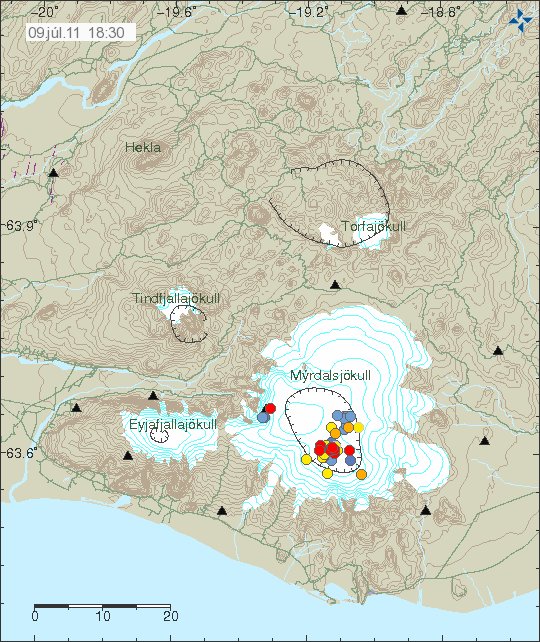
It seems that Katla volcano earthquakes are increasing again. This increase appears to be similar to the increase in earthquakes before the glacier flood from the 9th to 17th of June and onwards until the glacier flood on 8th and 9th of July. The only difference now is that I am seeing this pattern earlier since I now know what to look for this time around when this is in its early stages.

How this is going to develop now is a wait and see process. But this might take as long time to get interesting as it did in June to July, to the event that ended with the glacier flood from Mýrdalsjökull glacier.


Current earthquake activity in Katla volcano. Copyright of this picture belongs to Icelandic Met Office.

It is also worth noticing that the earthquake activity is not as focused as it was in early June and in July. But I am fully expecting that to happen soon. But it remains to be seen if that actually happens or not.

The earthquake activity SSE in the Katla volcano caldera rim is still interesting. I do not know why it is taking place there. But if a eruption would take place at this location. There would be a short glacier flood and some period with volcano ash explosions. But after that it should be lava eruption in that location if it where to last long enough to remove all that water from the crater. But this is all just a speculation and nothing more.

For now. It is just wait and see what happens next.