Update on Geophone network plan

I sometimes change my mind on my plans. I have changed my mind on turning off my geophone network in Iceland. After 10 years I am not going to be shutting it down. But I am going to continue to run it in the future. But after 10 years I am going to due some changes. What changes that are going to be exactly I am not sure yet. Depends on my wealth and what I can do. But one thing is for sure. I am am going to start building a geophone / seismometer network in Falkland Islands (link to my Falkland Islands geology blog) after 10 years. Regardless if I move there or not. Details on that plan depends on many factors that are not clear yet. Things often change when it comes down my plans. But that is just how it goes.

Glacier-quakes and ice-quakes taking place in Iceland

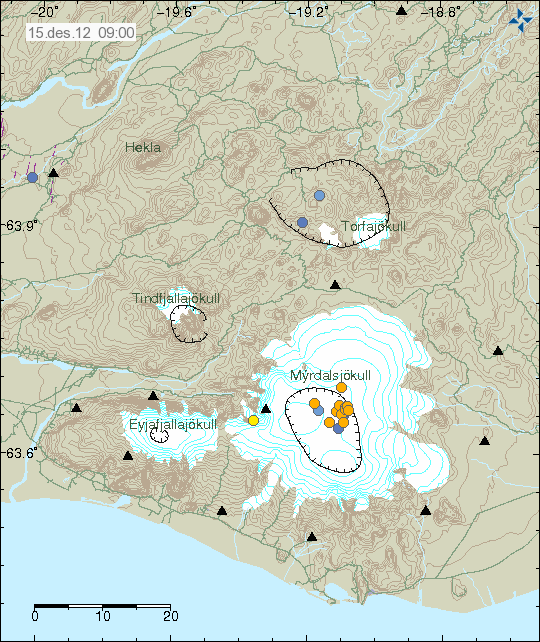
In some parts of Iceland, mostly in the high areas of Iceland the ground is freezing over this time of the year. This is creating a lot of glacier-quakes and ice-quakes in Iceland. On Icelandic Meteorological Office earthquake maps this appears as earthquakes with extremely poor quality. Many of the earthquakes in and around Mýrdalsjökull glacier and Eyjafjallajökull volcano are glacier-quakes and ice-quakes.

So while it might appear as a lot of earthquake activity is taking place. That might not be true earthquakes. In this case, it is best to wait for reviewed data on this activity. To see what is real earthquake activity and what is not real earthquake activity.

Weak harmonic tremor pulse from Hamarinn volcano

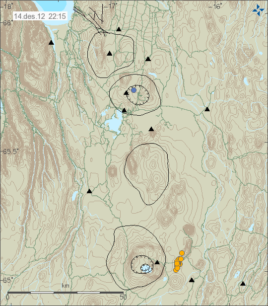
Since around 19:00 UTC (16.10.2012) a harmonic tremor pulse has been taking place in Hamarinn volcano (Bárðarbunga volcano). There is in my view no eruption taking place at the moment. This is most likely a dike intrusion of magma somewhere in the area of Hamarinn volcano. That might however trigger an eruption. But we just need to wait and see on that for the time being. This activity is interesting, as there was a small eruption in this area in July 2011.


The harmonic tremor pulse is strongest on this SIL station. But it is weak regardless. The signal suggest this event is taking place close to this SIL station location. Copyright of this image belongs to Icelandic Meteorological Office.


The harmonic tremor pulse also appears on Skrokkalda SIL station. But is weak and can hardly be detected on it. Copyright of this image belongs to Icelandic Meteorological Office.

The harmonic tremor pulse can be seen at the end of the above SIL station traces. The harmonic tremor pulse is higher then normal background noise (wind, ocean waves, human traffic, etc) on the SIL station. I do not expect this to be noise. The signal is too strong for that. It also hard to travel in this part of Iceland in October due to bad weather and difficult conditions in the high areas of Iceland.

New hydrothermal area found in Steingrímsfirði, north-west Iceland

New hydrothermal area has been found somewhere off the coast of West-Iceland. In a fjord named Steingrímsfjörður. The exact location of this hydrothermal area is not known at current time. But it’s existence was confirmed by a rock that was found by a fisherman in the area. But it was captured by his fishnet.


The hydrothermal area is somewhere in this area out in the ocean. Exact location is unknown at present time. Image is from Wikipedia. Original copy can be found here.

Little is known of this area for now. But it is there based on the evidence of the rock formation. The water in this hydrothermal area is around 60 to 80C warm. That is a guess based on other well known hydrothermal areas close to this area.

Icelandic news about this. With limited details on this.

Hverastrýtur í Steingrímsfirði (strandir.is)

New earthquake swarm east of Grímsey Island

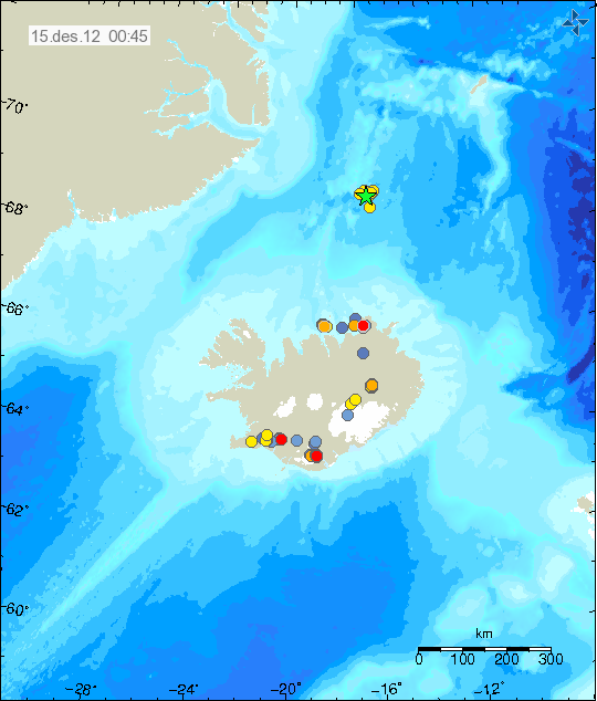
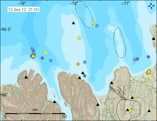
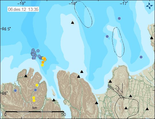
This night there where two minor earthquakes on TFZ (according to the Richter scale). According to automatic results from Iceland Meteorological Office. The first earthquake had the magnitude of ML3.7 and the second earthquake had the magnitude of ML3.5. Many smaller earthquakes took place between this earthquakes. Most of them with the magnitude of 1.0 to 2.5. Earthquake activity is currently ongoing in this area at the moment. Earthquake activity started east of Grímsey Island around 00:04 UTC, 13.10.2012. The first earthquakes where smaller then 2.0 in magnitude.


The earthquake swarm on TFZ during the night. Copyright of this image belongs to Icelandic Meteorological Office.

This area of TFZ is well known for earthquake activity. During past few weeks it had several earthquake swarms around this location. More earthquakes should be expected in this area in next few hours to days. I do not know if any of this earthquake activity has been felt in Grímsey Island.

Blog post updated at 08:05 UTC.

New volcano monitoring project in Iceland

A new volcano monitoring project and a study is about to start in Iceland. This project hopes to provide real time information in volcano activity in Iceland. It has been funded by EU grand of 6 million euros. The reason for this project is the Eyjafjallajökull volcano eruption, among other volcano activity in Iceland. Among this project goals is to setup coordinated European volcano monitoring system.

Freysteinn Sigmundsson geophysics is the controller of this project. Icelandic Meteorological Office and University of Iceland also take part in this project. In total, 26 partner in 9 European countries are going to take part in this project during its duration. Something about 200 scientists are going to take part in this project during its duration. It is going to be interesting to see what comes out of this project in the long run.

Update 1: I forgot the name of this project. It is called; European volcanological supersite in Iceland: a monitoring system and network for the future

Icelandic news on this

Bætt mannlíf nærri eldfjöllum (Rúv.is)
Milljarður í eldfjallaverkefni íslensks vísindamanns (Vísir.is)
Fá 950 milljónir í rannsóknarstyrk (mbl.is)

Blog post updated at 14:26 UTC.

Earthquake swarms in Brennisteinsfjöll volcano and TFZ

Over the past few days there has been continued earthquake activity in Breinnisteinsfjöll volcano. The largest earthquake in this swarm had the magnitude of ML2.5. It is possible that this earthquake swarms have there orgin in SISZ. Rather then Breinnisteinsfjöll volcano. But at current time is hard to be sure on this detail.


Earthquake activity in Breinnisteinsfjöll volcano during the past few days. Copyright of this image belongs to Icelandic Meteorological Office.

Tjörnes Fracture Zone

Earthquake activity has also been taking place east of Grímsey Island. This earthquake activity has mostly been small. But this are earthquake swarm did not have any earthquake that was above 3.0 in magnitude.


Earthquake swarm on TFZ. Copyright of this image belongs to Icelandic Meteorological Office.

The largest earthquake in this swarm had the magnitude of ML2.8. More earthquake activity should be expected in this area. As this is one of most active areas in Iceland when it comes to earthquake swarm.

Magnitude 3.8 earthquake in Breinnisteinsfjöll volcano

Earthquake with the magnitude of 3.8 took place in Breinnisteinsfjöll volcano at 19:42 UTC. This earthquake was felt in Reykjavík and nearby area. Many aftershocks have followed this earthquake. Most of them are however below 2.0 in magnitude. There was also pre-earthquake activity before the magnitude 3.8 earthquake did take place. Most of those earthquakes where below 2.0 in magnitude. Last month an earthquake with the magnitude 4.3 took place in this same area. Earthquake activity is currently ongoing with smaller earthquakes for the time being.


Green star marks the place where the magnitude 3.8 earthquake took place. Copyright of this image belongs to Icelandic meteorological Office.

So far there is nothing to suggests that current earthquake activity is nothing but tectonic. But this area is a riftzone. So there are earthquake swarm often take place there without them being related to any volcano activity in this area. This earthquake swarm appears clearly on my geophone network in Iceland. I am going to continue to monitor this earthquake activity. As more strong earthquakes in this area can take place in the next few hours to days.

Icelandic news about this earthquake activity

Jarðskjálfti upp á 3,8 í Bláfjöllum (Rúv.is)
Jarðskjálftar við Bláfjöll (mbl.is)
Jarðskjálfti í Bláfjöllum (Vísir.is)
Skjálftinn var 3,8 stig (mbl.is)

Earthquake swarm east of Grímsey Island.

This morning a earthquake swarm started east of Grímsey Island. This is activity in TFZ area that possibly has two active volcanoes (GVP information). This is however most likely just a normal earthquake activity taking place now in this area of Iceland. The largest earthquake in this earthquake swarm was a magnitude 3.1 earthquake that took place at 11:35 UTC.


Earthquake swarm on TFZ. Copyright of this image belongs to Icelandic Meteorological Office.

This earthquake swarm might continue for the next few hours. With the possibility of more earthquakes reaching magnitude 3.0 or larger. But it is common for earthquakes swarms in this area to just stop over period of few hours. The largest earthquake in this earthquake swarm was not felt according to the news.

Icelandic news about this earthquake swarm

Jarðskjálfti norðan Grímseyjar (Rúv.is)
Jarðskjálftahrina við Grímsey (mbl.is)

Magnitude 3.1 earthquake in Katla volcano this morning

Today at 08:26 UTC this morning a magnitude 3.1 earthquake took place in Katla volcano. There was minor pre-earthquake activity before the magnitude 3.1 earthquake took place, the depth of this earthquake was around 100 meters (0.1 km). There was also some minor aftershock activity following this earthquake. No change in harmonic tremor took place following this earthquake. So there is a good chance this was just part of normal autumn activity in Katla volcano. This earthquake activity did appear clearly on my geophone network. It can be viewed here on my geophone network web page.


The earthquake as it did appear on my geophone station in Skeiðflöt. This image is released under Creative Commons licence. See CC licence page for more details.


The earthquake as it did appear on my geophone station in Heklubyggð. This image is released under Creative Commons licence. See CC licence page for more details.


The location of the earthquake in Katla volcano. Copyright of this image belongs to Icelandic Meteorological Office.

More earthquakes like this should be expected in Katla volcano. But it is impossible to know if there is going to be an eruption in Katla volcano any time soon. But so far everything is quiet in Katla volcano. Besides occasional earthquake swarm that is taking place in Katla volcano.

Icelandic news about this earthquake activity

Jarðskjálfti í Kötlu – 3,2 að stærð (Rúv.is)
3,2 stiga skjálfti í Kötlu (mbl.is)
Snarpur skjálfti í Kötlu (Vísir.is)

Blog post updated at 19:34 UTC on 03.10.2012
Blog post updated at 05:45 UTC on 04.10.2012