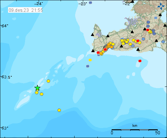
Today (9. December 2023) at 05:55 UTC to 06:44 UTC an earthquake swarm took place deep on the Reykjanes ridge. This earthquake swarm is far from the coast so smaller earthquakes where not detected by Icelandic Met Office. Largest earthquake in this swarm had a magnitude of Mw3,8.
Earthquake activity deep on Reykjanes ridge. Copyright of this image belongs to Icelandic Met Office.
This is in a volcano, its unclear if this is in the volcano Eldeyjarboði or a different unnamed volcano. This earthquake swarm seems to have stopped by now.
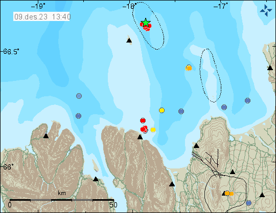
Today (9. December 2023) an earthquake swarm took place east of Grímsey island, it started at 11:09 UTC and ended around 12:19 UTC. This was a small earthquake swarm and largest earthquake had a magnitude of Mw3,0.
Earthquake swarm east of Grímsey island. Copyright of this image belongs to Icelandic Met Office.
This area of Tjörnes Fracture Zone has frequent earthquakes and earthquake swarm activity. Large earthquake swarms happen in this area every few years. Time between them is different. If that is the case now is impossible to know.
This is a short article about the situation in Grindavík. Information here might go outdated quickly without warning.
Sorry for the late update. I was updating my computer and its been more of a problem than I expected. Since I build my own computers, rather than buying already assembled computer.
Overview of the situation in Grindavík
Inflow into the dyke seems to have stopped one to two days ago. This means that it has started to cool down, since no inflow of fresh magma means it starts to form into rock. This is going to take years and in some areas decades cool all the way through. This also means that the rift valley is no longer moving as much as it was doing and in some areas has stopped completely. There is a crust instability in and around Grindavík town because of the rift valley, but this instability is now lower compared to first few days after 10. November. This might continue for years, even after all eruption activity stops few hundred years into the future.
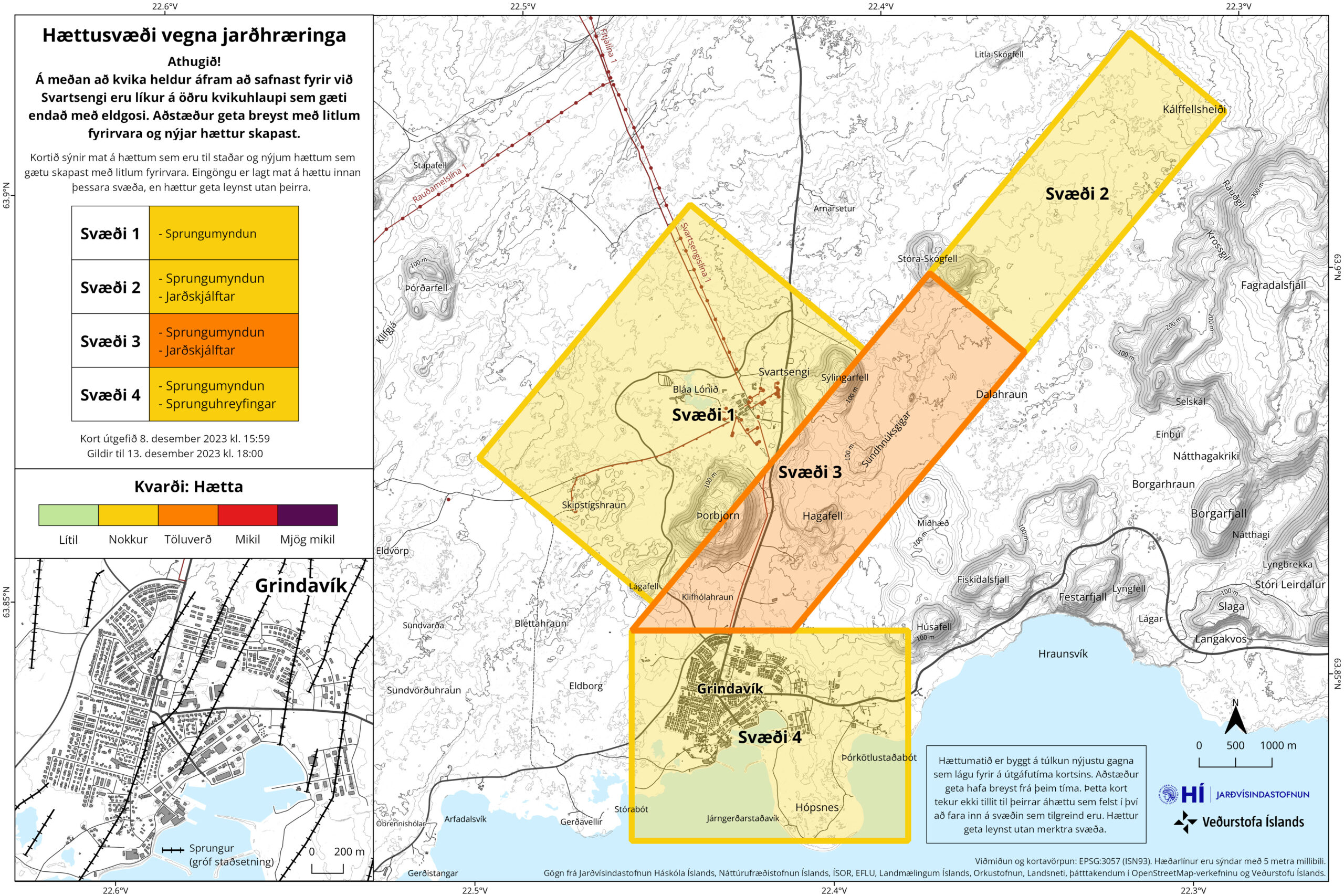
Inflation has now reached almost the same level as 10. November, with only 50mm to go until the same level is reached. This inflation seems to be creating cracks in the ground around Svartsengi power plant. But the news was not clear on exact area of the formation of those cracks in the ground. Svartsengi, Grindavík and the area around the dyke continues to be a danger zone as defined by Icelandic Met Office.
The danger zones in Grindavík. Copyright of this image belongs to Icelandic Met Office.
The original image can be found here on Icelandic Met Office website.
This is not over and it is impossible to know when next sequence of events starts in Svartsengi and there is going to be little to no warning when it starts next. Icelandic Met Office has sad that at most there is going to be a two hour warning before an eruption starts, but it might even be shorter time. Making staying in Grindavík and nearby area all hours of the day a dangerous thing to do.
This is the last update until something happens in Grindavík.
This is a short update and information here can go outdated quickly and without warning.
There has not a lot been happening in last few days. Here is a overview for the last few days.
Inflation continues in Svartsengi. Over the 90 day GPS data period. The inflation has reached the zero line. That means the inflation is now at the same level as it was before 25. October 2023. It still has about 100mm to go before it reaches 10. November levels and the sill broke and the magma dyke happened. But it is important that the GPS data from 2020 shows that Svartsengi lowered to 140mm below the January 2020 starting point with the GPS data.
The GPS data from January 2020 for Svartsengi show that total inflation in the area is around 230 to 250mm. This information can be viewed here (this is a none https link, so it might require an exception in Google Chrome or just use Mozilla Firefox). There’s a lot of GPS data on this site. Some of it show short term GPS data that are from last 12 hours daily update. Looking for the correct data image might take some time.
Inflation might need to reach 10. November levels before anything happens again. The dyke even on 10. November seems to have changed how things happen in Svartsengi so it is impossible to be sure what happens next.
While the magma collecting phase is ongoing. Things are going to be quiet with the earthquake activity in this area.
The rift valley, best I can see, continues to change and sink and rise. Resulting in ongoing damage to Grindavík town.
There’s less news about this at currently. That gives me less information on what is going on.
Next update should be by Friday 8. December, unless something happens.
Information here might go outdated quickly and without warning. This article is written on 30. November 2023 at 23:44 UTC.
There isn’t much change happening at the moment. People are now allowed to be in Grindavík between 07:00 to 19:00 I think the time frame is. Earthquake activity is at minimum currently.
Daily update
Deepest hole that has been discovered so far is 25,7 meters deep. It is deeper, but at 25 meters the ground water level starts and hides the actual depth of this crack. Rúv news about this found here with pictures and videos in Icelandic.
New cracks and the ground continues to sink and move in most of areas of Grindavík. This is resulting in more damage to houses and streets in Grindavík town.
The harbour area in Grindavík has lowered 30 cm to 40 cm. That was the news two days ago. I think the harbour area continues to sink. This might be a signs of future problems if the ocean manages to flow into this area.
Svartsengi volcano continues to inflate at the rate from 10mm to 40mm a day. The last 24 hour inflation was around 40mm. Earlier the inflation had just been 10mm a day. Suggesting a increased flow of magma into Svartsengi volcano.
Something might start to happen around or after 9. December when the sill in Svartsengi is expected to reach the same pressure it was on 10. November when it broke the first time and emptied and created the dyke that formed under Grindavík and the nearby area.
Cookie acceptance
We use cookies on our website to give you the most relevant experience by remembering your preferences and repeat visits. By clicking “Accept”, you consent to the use of ALL the cookies.
This website uses cookies to improve your experience while you navigate through the website. Out of these cookies, the cookies that are categorized as necessary are stored on your browser as they are essential for the working of basic functionalities of the website. We also use third-party cookies that help us analyze and understand how you use this website. These cookies will be stored in your browser only with your consent. You also have the option to opt-out of these cookies. But opting out of some of these cookies may have an effect on your browsing experience.
Necessary cookies are absolutely essential for the website to function properly. This category only includes cookies that ensures basic functionalities and security features of the website. These cookies do not store any personal information.
Functional cookies help to perform certain functionalities like sharing the content of the website on social media platforms, collect feedbacks, and other third-party features.
Performance cookies are used to understand and analyze the key performance indexes of the website which helps in delivering a better user experience for the visitors.
Analytical cookies are used to understand how visitors interact with the website. These cookies help provide information on metrics the number of visitors, bounce rate, traffic source, etc.
Advertisement cookies are used to provide visitors with relevant ads and marketing campaigns. These cookies track visitors across websites and collect information to provide customized ads.