Are Esjufjöll volcano starting to inflate ?

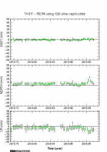
I have been monitoring the GPS station at Grímsfjall volcano. After the earthquakes that took place in Esjufjöll volcano few weeks ago something interesting started to happen at that GPS station. It started to move in north direction.

Due to the location and lack of activity in Esjufjöll volcano there are almost none GPS stations around that volcano, and there are not many SIL station in this area. So getting insight into what is happening in Esjufjöll volcano is hard. But given the GPS station at Grímsfjall volcano it seems to that Esjufjöll volcano have started to inflate. It is hard to know exactly by how much at current time. But it appears to enough to have effect on the GPS station at Grímsfjall volcano.

This is given that Grímsfjall volcano it self is not having any inflation south of the GPS station on it’s own. At the moment it is hard to know what volcano is responsible for the northward movement. Only time is going to tell us the truth in that matter.

Grímsfjall volcano GPS data (automatic, Icelandic)

Earthquakes in eastern part of Katla volcano (Mýrdalsjökull)

Last week something interesting started to happen in Katla volcano last week (Week 45). Earthquakes started to appear in the eastern part of the Katla volcano. This is higly unusual and is not the normal earthquake zone in Katla volcano. But normally the earthquakes take place in the western part of the Katla volcano (Goðabungu area) and few earthquakes take place in the caldera it self at regularly.

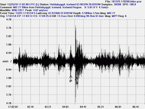
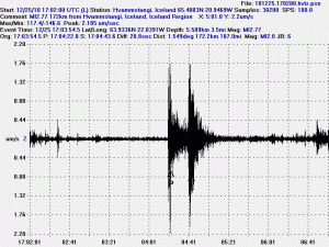
At 00:45 UTC there was a earthquake in eastern Katla volcano, the automatic SIL size of this earthquake was ML2,5 at the depth of 1,1Km (with a good quality of 90,05). Both figures are subject to a revision by a seismologist at later time, so both size and depth can change. I did manage to record this earthquake on my Hekla geophone, even if there currently is rather high wind noise at my geophone. What I did see on my geophone is interesting. But the earthquake appears to have low frequency component in it, even if it is mostly high-frequency type of earthquake. But those earthquakes are normally created by a fault in the crust, not by magma movement.

I need more data to confirm it. But there are clues that the earthquakes in eastern Katla volcano are due to magma movement, rather then tension changes in the crust not related to magma movement. What is happening there is unclear at the moment, as GPS stations around Katla volcano do not show anything interesting at the moment.

No eruption is imminent in Katla volcano at current time.

Tröllaskagi and a extinct volcano

Here are pictures of Tröllaskagi from a town called Sauðárkrókur.

Tröllaskagi to the north from Sauðárkrókur. Click on the picture for larger resolution.

Tröllaskagi to the east from Sauðárkrókur. Click on the picture for larger resolution.

Tröllaskagi to the south from Sauðárkrókur. Click on the picture for larger resolution.

Tröllaskagi is a really mountainous region of Iceland. Few people live there. But there are some farms in few of the deep wallies there. But not many to my knowledge. This area also once hosted a large glacier. But there are few remains left of it today. This area is mixed in rock. But this rock also holds a different age and origin far as I know. There are theories that this might be a old continent crust that make up Tröllaskagi.

The extinct volcano

There are more interesting things around Sauðárkrókur then just Tröllaskagi. This caldera is one of the visible features from Sauðárkrókur. The current conclusion about this caldera it is extinct. While I personally don’t agree with that and believe that it might still be active given it shape. I have no way to prove it, unless it starts to erupt all of a sudden. This is a stratovolcano with a small caldera. This volcano formation is small compared to many other Icelandic volcanoes. Both active and extinct.

A zoom in of the extinct volcano caldera. Click on the picture for higher resolution of it.

A wide angel view of the extinct volcano caldera. Click on the picture for higher resolution of it.


View Larger Map

A Google Map view of the extinct caldera from the above. It is a bit hard to see it from above.

The volcano also is on a rift zone that for some unknown reasons is not active at the moment. But a study on this rift zone can be found here (pdf) in English. I don’t know if this rift zone is going to get re-activated in the future or not. Currently there are few to none earthquakes in this rift zone.

More earthquakes at Esjufjöll volcano

It seems that Esjufjöll volcano is not done with the earthquakes. But over the past few weeks since the original earthquakes swarm that started in early October in Esjufjöll volcano.

Like before it appears that the earthquakes have there origin, not tectonic as often is the case is in Iceland. But this means that each time a earthquake happens in Esjufjöll volcano a magma is on the move there. What is interesting about this is the fact the magma that is moving inside Esjufjöll volcano does appears to be moving at fast rate. For instance the earthquakes that are now taking place in Esjufjöll volcano indicate that the magma is moving faster then was the case with Eyjafjallajökull volcano before it erupted earlier this year. According to Week 42 data from Icelandic Met Office there where over 70 earthquake recorded. But in 2002 the earthquakes recorded then was over 90 earthquakes, with the biggest one ML3,5 in size.

The current earthquakes in Esjufjöll volcano are interesting and do signal a more active period ahead in that volcano. When that active period is going to peak with a eruption (?) is unknown at this time. But we at least might end up seeing (?) something like happened in the year 1927 when a small eruption did create a glacier flood from Esjufjöll volcano that did go down Breiðamerkujökull glacier.

A notice from my host provider about maintenance

There is going to maintenance on the network that my web site is hosted on the 14th of November 2010. Here is the message that I got from my hosting provider.

Scheduled Date and Time:
Sunday, November 14, 2010. Begins at 3 AM EST and will last through 4 AM EST

Maintenance Type:
Our network admins will be performing an internal network infrastructure upgrade that will greatly enhance our internal routing capacity which in turn will directly benefit your account(s).

Estimated Downtime:
While we will do everything possible to expedite the maintenance to reduce issues, the downtime associated with this process should only consist of 5 – 10 minutes of downtime during the specified maintenance window.

There might be some downtime on this web site when this maintenance takes place.

Advertising policy

I have decided to place advertisements on this blog. I am just going to go with Google Adsense and Amazon ads. I am going to keep the ads as few I can. Since I generally don’t like ads that much. But like everyone else I need to eat and buy useless stuff from the internet. This will also help be building my own seismometer network in Iceland. For that I need money and I apparently can get money from letting Google and Amazon display ads on my blog.

I have also dedicated to put ads on my earthquake helicorders web pages. But that is going to require a little more thinking on how to do it smoothly and without annoying the users of my earthquake monitoring web pages. That is also going to help me to build a earthquake monitoring network in Iceland with time.

There is also going to be a option for donating money to me and my work if people want. But I am unsure when I finish setting that option up. But there are few weeks until that happens at least.

I am thinking this a similar format as Universe Today uses (but less annoying) and also Spaceweather.com uses today.

With this blog post on this matter I wanted to give my readers a heads up on what is coming in regards to changes to my blog and my earthquake monitoring web pages. I am going to start applying this next weekend I hope. I am unsure at this time how long time it is going to take me to fully implement this, it depends on the problem that I might challenge me on the way to implement this.

Text updated at 16:37 UTC.
Text updated at 19:01 UTC

Uncertainty level for Grímsfjall volcano cancelled

According to Icelandic news it seems that Almannavaranir (Iceland Civil Authority) have cancelled the uncertainty level for Grímsfjall volcano. But the uncertainty level was put in place following the glacier flood from Grímsvötn glacier lake.

The announcement from Iceland Civil Authority in Icelandic. Please use Google Translate.

Óvissustigi aflýst vegna Grímsvatna (Icelandic)

Icelandic News. Please use Google translate.

Óvissustigi aflýst vegna Grímsvatna (Vísir.is)

Earthquakes in Iceland, a short overview

I have seen a lot of people worrying about earthquakes and earthquake swarms that take place in Iceland on regular basic. Those worries are not needed as Iceland gets about one to two earthquake swarms on average over the course of one week. Most of the earthquakes that take place in Iceland are tectonic in nature. There are also volcano related earthquakes. But they can be spotted by there location in connection with the volcano in question (Katla, Grímsfjall, etc..).

The reasons for the earthquake swarms in Iceland is geological and is because Iceland sits on a rift zone. This can be shown clearly on this picture here.


Click on picture to get better resolution.

This map clearly shows all the zones in Iceland. In this areas most of Iceland earthquakes happens. But also a big part of Iceland earthquakes happen in areas like SISZ and TFZ.

On the normal week there are about 150 to 400 earthquakes in Iceland over the week. Most of them are in the size ML0.0 and up to ML2.8. Most week have one or two earthquakes that are ML3.0 to ML3.8 in size. On a quiet week there are about 50 to 100 earthquakes, most of them less then ML2.5 in size. When there is a busty week in Iceland the earthquakes numbers can easily go over 2000 and sometimes well over 5000 earthquakes. When that happens IMO doesn’t even bother in classifying and locating all the earthquakes that take place. But they are saved anyway in IMO database.

Picture taken from this blog: Earthquake in Iceland (2008); This blog has more images about the tectonic process in Iceland.

Glacier flood subsides, harmonic tremors drops down

According to the news the glacier flood from Grímsvötn is subsiding and is expected to be over in the next two to three days. At the same time the harmonic tremor that started at 3rd of November 2010 is also subsiding. No clear reason is for the harmonic tremors.

Currently there is nothing that indicates that a eruption is about to start in Grímsfjalli. But that can change with a short notice, as Grímsfjall sometimes does not give a long warning before it starts erupting.

Icelandic News. Please use Google Translate.

Farginu létt af eldstöðinni (Vísir.is)
Hlaup í rénun (Rúv.is)

English news.

Flood waning, Iceland volcano eruption less likely (washingtonpost.com) – Thanks to Erik for this news.