Bárðarbunga volcano one year ago

One year ago activity in Bárðarbunga volcano was increasing, the week before a constant earthquake swarm had been taking place in the volcano. I had planned to write about that earthquake swarm that had been taking place, that never happened due to sudden increase in Bárðarbunga volcano the day that I had planned on writing about the earthquake swarm (I don’t have that image, I think, at least I can’t find it, I possibly did not save it due to me forgetting doing so).

140816_1145
The earthquake activity in Bárðarbunga volcano at 11:45 UTC on 16-August-2014. This was just the start. Copyright of this image belongs to Icelandic Met Office.

dyn.svd.16.08.2014.12.01.utc
It was clear that on 16-August-2014 that something was going on when I looked at the harmonic tremor plot at Iceland Met Office website. It was going crazy. Copyright of this image belongs to Icelandic Met Office.

It was clear when looking at the harmonic tremor plot that something was going on and what was happening was big.

140818_1440
Green stars numbers increased as the time passed on the map, so did the magnitude and number of the earthquakes in Bárðarbunga volcano. Copyright of this image belongs to Icelandic Met Office.

When 25-August-2014 came the number of earthquakes taking place in Bárðarbunga volcano was in the thousands and earthquakes with magnitude 3,0 and larger was in the hundreds.

140825_2015
Earthquake activity in Bárðarbunga volcano on 25-August-2015. Copyright of this image belongs to Icelandic Met Office.

The largest earthquake that happened before the eruption started took place on 26-August-2014, it had the magnitude of 5,7 and is the largest earthquake in Iceland since 2008.

140826_2200
The earthquake activity in Bárðarbunga volcano on 26-August-2015. Copyright of this image belongs to Icelandic Met Office.

140826.012500.bhrz.psn
The magnitude 5,7 earthquake on my geophone in Böðvarshólar. This image is under Creative Commons License. Please see CC license page for more details.

140826.012538.hkbz.psn
The magnitude 5,7 earthquake on my geophone in Heklubyggð. This image is under Creative Commons License. Please see CC license page for more details.

Once the eruption started in Bárðarbunga volcano by the end of August-2014 most of the earthquake activity stopped, it did continue with one to three magnitude five or larger earthquakes in Bárðarbung volcano caldera as it collapsed due the magma outflow in Holuhraun eruption area. That earthquake activity continued until end of February, when the eruption was just about the end in Holuhraun.

Early signs of what was about to happen in Bárðarbunga volcano

It is difficult to know for sure what are the early signs in Bárðarbunga volcano until after an eruption has started. One of the few clues that I know about was earthquake activity like this one. It was considered a normal earthquake activity for Bárðarbunga volcano, there is a good chance that it was a activity telling scientist that Bárðarbunga volcano was about to erupt soon.

140516_2125
Earthquake activity in Bárðarbunga volcano on 16-May-2014. Copyright of this image belongs to Icelandic Met Office.

It is difficult at best to know if an volcano is about to erupt or not. Clues are also difficult to see since the process of why and how eruption happens is often hard to see when data is missing, as is the case with volcanoes with long period of quiet.

Status of Bárðarbunga volcano at the moment

Currently there isn’t a lot happening in Bárðarbunga volcano. However, based on earlier historical record it is clear that current eruption activity in Bárðarbunga volcano is possibly not over yet. There is a good chance of new eruptions over the next time period of 10 – 15 years. The time between eruptions is everything from 1 year and up to 10 years (about). Quiet period in Bárðarbunga volcano can last up to 100 years, the current one that ended in 2014 lasted good 104 years. Where and when next eruption is going to take place in Bárðarbunga volcano is anyone guess, all that I know for sure is that it is going to happen and next eruption might be as big as the one in Holuhraun that ended six months ago.

The rate of eruptions in Iceland

It is a common misconception that eruptions take place in Iceland every 4 to 5 years. That is the average number of years between eruptions. The actual picture of the eruption rate in Iceland is far from this simple. Eruption activity in Iceland happens in periods of 50 to 80 years. With long quiet periods between them that last up to 50 to 80 years. The period of high activity and low activity are about equally long according to scientific data. The longest period of quiet took place in the year 1720 to 1880, that is a quiet period of 160 years. The shortest period of quiet took place 1620 to 1720, this is a period of 100 years. The rate of eruptions during the active areas is 4 to 11 eruptions over a period of 40 years, but during the quiet period that number is 0 – 4 eruptions over a period of 40 years. In every case but one the eruptions where in Grímsfjall volcano.

Last peak in eruptions in Iceland took place in the years 1880 to 1900. Last eruption low took place in the year 1960 in Iceland. Before that this low in activity took place in the year 1820. The reason for this behaviour is that activity in the rift zone happens in jumps. It is not even activity with long quiet periods between them. [Speculation] If I use basic maths to figure out when next peak in activity is going to start, it puts it down in the year 2020. If that is going to happen is something that remains to be seen.

Reference material in Icelandic

Sigurður Steinþórsson. „Er eldvirkni á Íslandi sveiflukennd?“. Vísindavefurinn 19.7.2000. http://visindavefur.is/?id=672. (Skoðað 29.5.2014).

Donations: Please remember to donate to support my work. I don’t plan to use Google Adsense again. It is not worth the problems that it brings with it. If you buy something from Amazon via my banners (or this website) or my aStore (link here). I get 5 to 10% of the sale price as an advertisement fee (I don’t know the proper English for this, so this is going to have to do). Thanks for the support.

50 years since Surtsey island erupted

On the 14-November-1963 an eruption started off the south coast of Iceland. This eruption lasted for several years, starting on 14-November-1963 and ending on 5-June-1967. This new island was later known as Surtsey. This eruption was an start of eruption period in the otherwise unnamed volcano in this area, inside this volcano also exist Vestmannaeyjar islands. Only ending in the year 1973 with an eruption in Vestmannaeyjar islands. Surtsey is an protected islands and tourist are not allowed to go there under any circumstances. Only scientific missions to check on the developing flora on the island are allowed to go there few times a year.

Rúv News did broadcast a news about the 50 years since the eruption in Surtsey and they included a lot of pictures of the eruption as it took place in Surtsey in the year 1963. That news coverage can be found here, but it is all in Icelandic. It includes an video from Rúv News.

Comparison of volcano eruptions

When there is nothing going on in Iceland. It is good to prepare for the future by checking out what has happened in the past. Here is a comparison of harmonic tremor data from few past eruptions. I only have limited set of data to work with here.

Grímsfjall volcano eruptions 2004 and 2011

Harmonic tremor indicates how strong the eruption is when it is happening. This is clearly visible on the harmonic tremor plots from the Grímsfjall volcano eruptions in the year 2004 and compared to the eruption in Grímsfjall volcano eruption in the year 2011.


Harmonic tremor in Grímsfjall volcano eruption in the year 2004. Copyright of this image belongs to Icelandic Meteorological Office.

This harmonic tremor plot is from the early start of the eruption. It clearly shows when the eruption starts and how it progressed during it’s first few hours.


Here is the volcano eruption start in Grímsfjall volcano on 23. May 2011. This is the start of the eruption. It clearly shows the difference from the eruption that took place in the year 2004. Both is that starts sharper. But is also a lot more powerful then the eruption in the year 2004. Copyright of this image belongs to Icelandic Meteorological Office.

Eyjafjallajökull volcano and Katla volcano

Sometimes it is useful to compare two eruptions of two different volcanoes. This is useful when you really don’t have anything else to compare with.


Harmonic tremor in Eyjafjallajökull volcano eruption back in the year 2010. This is from the second phase of the eruption. But I seems to have misplaced or not saved harmonic tremor data from the first phase of the eruption (at least I cannot find them for the moment). Copyright of this image belongs to Icelandic Meteorological Office.


Harmonic tremor connected to a minor eruption in Katla volcano in July 2011. This eruption was minor. But created a flood that took out a bridge. Copyright of this image belongs to Icelandic Meteorological Office.


Diffrent SIL stations from the same minor eruption in Katla volcano in July 2011. This clearly shows that this minor eruption in Katla volcano was possibly larger then eruption in Eyjafjallajökull volcano year earlier (2010). But it did not manage to break the ice of Mýrdalsjökull glacier. Copyright of this image belongs to Icelandic Meteorological Office.

Past data show and are useful to learn what happens in a volcano. For this reason I now save important information on what is happening in a volcano. So I can compare it with future activity when it takes place.

List of known eruptions in Grímsfjall volcano and connected volcanoes

Here is an list of eruptions in Grímsfjall volcano and Þórðarhyrna volcano based on data from Global Volcanism Program and documented eruptions. In most cases, eruptions that took place in the early 10 to 16th century are poorly documented if they where smaller eruptions. This even goes on somewhat into the 20th century.

Year ~8230BC +-50 years. Area of activity, unknown. Size VEI=6. Known as Saksunarvatn tephra layer. Dating done with Radiocarbon (corrected).

Year ~4550BC +-500 years. Area of activity, Laki. Size VEI=0. Dating method, Tephrochronology.

Year ~3550BC +-500 years. Area of activity, S of Þórðarhyrna. Dating method, Tephrochronology.

Year ~1950BC +-100 years. Size VEI=2 Area of activity, Raudholar and Brunuholar. Dating method, Tephrochronology

Year ~50BC. Size VEI=2. Area of activity, Halsagigur. Dating method, Tephrochronology

Year ~910AD. Area of activity, ?. Dating method, Tephrochronology.

Year ~960AD. Area of activity, ?. Dating method, Ice core.

Year ~1010. Area of activity, ?. Dating method, Ice core.

Year ~1060. Area of activity, ?. Dating method, Tephrochronology.

Year ~1090. Area of activity, ?. Dating method, Ice core.

Year ~1150. Area of activity, ?. Dating method, Ice core.

Year ~1190. Area of activity, ?. Dating method, Ice core.

Year 1230 +- 10 years. Area of activity, ?. Dating method, Ice core.

Year 1270 +- 10 years. Area of activity, ?. Dating method, Ice core.

Year 1290 +-10 years. Area of activity, ?. Dating method, Ice core.

Year 1310 +-10 years. Area of activity, ?. Dating method, Ice core.

Year 1332, November. Area of activity, ?. Size VEI=2. Dating method, historical documents.

Year 1341, May. Area of activity, ?. Size VEI=2. Dating method, historical documents.

Year ~1350. Area of activity, ?. Dating method, Ice core.

Year ~1354. Area of activity, ?. Dating method, historical documents.

Year 1369. Area of activity, ?. Dating method, Ice core.

Year 1370 +-10 years. Area of activity, ?. Dating method, Ice core.

Year 1390 +-10 years Area of activity, ?. Dating method, Ice core.

Year 1430 +-10 years. Area of activity, ?. Dating method, Ice core.

Year 1450 +-10 years. Area of activity, ?. Dating method, Ice core.

Year ~1469. Area of activity, ?. Dating method, Ice core.

Year 1470 +- 10 years. Area of activity, ?. Dating method, Ice core.

Year ~1471. Area of activity, ?. Dating method, Ice core.

Year 1490 +- 10 years. Area of activity, ?. Dating method, Ice core.

Year ~1500. Area of activity, ?. Dating method, Ice core.

Year ~1509. Area of activity, ?. Dating method, Ice core.

Year 1510 +- 10 years. Area of activity, ?. Dating method, Ice core.

Year 1521 +- 10 years. Area of activity, ?. Dating method, Ice core.

Year 1530 +- 10 years. Area of activity, ?. Dating method, Ice core.

Year 1598. November 7. Area of activity, ?. Size VEI=3?. Dating method, historical documents.

Year 1603. October 31. Area of activity, possibly Grímsvötn. It is unclear. Dating method, historical documents.

Year 1610. Area of activity, ?. Dating method, Ice core.

Year 1619. July 29. Area of activity, ?. Size VEI=2. Dating method, historical documents.

Year ~1622. Area of activity, ?. Dating method, Ice core.

Year 1629. Area of activity, ?. Size VEI=2. Dating method, historical documents.

Year 1632. Area of activity, ?. Dating method, Ice core.

Year 1638 February 24 +- 4 days. Area of activity, ?. Size VEI=2. Dating method, historical documents.

Year 1659 November. Area of activity, ?. Size VEI=?. Dating method, historical documents.

Year 1681 April 10. This might not be an eruption in Grímsfjall volcano.

Year 1684 November 5 +- 4 days. Area of activity, ?. Size VEI=2. Dating method, historical documents.

Year 1697. Area of activity, ?. Size VEI=?. Dating method, historical documents.

Year 1706 October 15 +- 45 days. Area of activity, ?. Size VEI=2. Dating method, historical documents.

Year 1716 October 6. Area of activity, ?. Size VEI=2. Dating method, historical documents.

Year 1725 February. Area of activity, ?. Size VEI=2. Dating method, historical documents.

Year 1730. Area of activity, ?. Size VEI=?. Dating method, historical documents.

Year 1753 October 15 +-45 days. Area of activity, ?. Size VEI=2?. Dating method, historical documents.

Year 1768. This eruption might not have taken place in Grímsfjall volcano.

Year 1774. Area of activity, ?. Size VEI=?. Dating method, historical documents.

Year 1783 to 1785 May. Stop date May 25 1785. Area of activity, Laki, Lakagígar. Size VEI=4+. Dating method, historical documents.

Year 1794. Eruption might not have been in Grímsfjall volcano. Somewhere in West Vatnajökull.

Year 1816 May. Area of activity, ?. Size VEI=?. Dating method, historical documents.

Year 1823 February 4 +-4 days. Area of activity, Grímsvötn-Þórðarhyrna. Size VEI=2. Dating method, historical documents.

Year 1838 June. Area of activity, ?. Size VEI=2. Dating method, historical documents.

Year 1854. Area of activity, ?. Size VEI=2. Dating method, historical documents.

Year 1861. This eruption is uncertain.

Year 1867 August 29. Area of activity, ?. Size VEI=1. Dating method, historical documents.

Year 1873 January 8, it ended in August. Area of activity, ?. Size VEI=4. Dating method, historical documents.

Year 1883 January 15, it ended in April 15 +-5 days. Area of activity, ?. Size VEI=2. Dating method, historical documents.

Year 1887 August 15, it ended in the year 1889. Area of activity, Þórðarhyrna. Size VEI=2. Dating method, historical documents.

Year 1891 November, it ended in March 16 1892. Area of activity, ?. Size VEI=2. Dating method, historical documents.

Year 1897. Location of this eruption in uncertain. Area of activity, ?. Size VEI=2. Dating method, ?.

Year 1902 December, this eruption ended in the year 1904 on 12 January. Area of activity, Grímsfjall and Þórðarhyrna. Size VEI=4. Dating method, historical documents.

Year 1910. Area of activity, ?. Size VEI=?. Dating method, ?.

Year 1919. This eruption is uncertain.

Year 1922 September 29 +-1 day. This eruption ended on October 23. Area of activity, ?. Size VEI=2. Dating method, historical documents.

Year 1933 November 29 +-1 day. This eruption ended on December 9 +-1 day. Area of activity, North of Grímsvötn Caldera. Size VEI=1. Dating method, historical documents.

Year 1934 March 30, this eruption ended on April 7 in the year 1934. Area of activity, Close to south caldera wall. Size VEI=2. Dating method, historical documents.

Year 1934. This eruption is uncertain. But it took somewhere in Vatnajökull glacier.

Years 1938 May. Area of activity, 8 km south of Svartibunki. Size VEI=1. Dating method, historical documents.

Uncertain eruptions the years 1939 June, 1941 April, 1945 September 25, possible VEI=1 eruption, 1948 February.

Year 1954 January 15 +-45 days. Area of activity, ?. Size VEI=1. Dating method, historical documents.

Year 1954 July, this eruption is uncertain. Area of activity, north and south part of the caldera. Size VEI=1?. Dating method, historical documents.

Year 1972 March. This eruption is uncertain.

Year 1983 May 28. This eruption ended on June 2. Area of activity, close to the south part of the caldera wall. Size VEI=2. Dating method, historical documents.

Year 1984 August 20 (or around that date). This eruption is uncertain.

Year 1996, September 30. This eruption ended on November 6. Area of activity, Gjálp fissure. Size VEI=3?. Dating method, historical documents.

Year 1998, December 18. This eruption ended on 28 December. Area of activity, South Caldera wall. Size VEI=3. Dating method, historical documents.

Year 2004 November 1. This eruption ended on November 4. Area of activity, South West and east sides of the caldera. Size VEI=3. Dating method, historical documents.

Year 2011, May 21. This eruption ended on May 30. Area of activity, South West part of the caldrea. Size VEI=3. Dating method, historical documents.

This is just short overview of the eruptions that have taken place in Grímsfjall volcano and in Þórðarhyrna volcano. It does not contain a lot of details on them. Please not that this blog post might contains errors. If you see them. Please comment on them and I am going to fix them soon as I can.

This blog post is going to be updated with time.

Historical eruption of Grímsfjall volcano of the year 1783 to 1785

The year 1783 is something that is going to live in historical memory of the Icelandic people for long time to come. The historical memory of Icelanders still remember the eruption of Laki that took place 229 years ago. This eruption is among Iceland biggest eruption in historical times and since Iceland got populated around the year 600 (or around that time, according to new data). It is unclear when the exact eruption started in Grímsfjall volcano and in Þórðarhyrna volcano (a smaller volcano south-west of Grímsfjall volcano, it is inside Grímsfjall volcano fissure swarm). But what is known is that this eruption started sometimes in May.

The eruption started in Grímsfjall volcano it self, it is unclear where exactly it started. Creating a glacier flood that did go down Þjórsá that same month in some part. But was documented that Þjórsá was darker and had worse smell then normally and had more water in it. It was also documented that Skaftá did have more water in it and was darker and had bad smell early spring in Iceland (that means late April or early May). But the glacier flood that must have taken place after an eruption started are not well documented in history best to my knowledge. From what I can read it seems that the eruption of Grímsfjall volcano started in the main volcano (unknown where exactly). The years 1755 and to the year 1785 seems to have been extremely active in terms of volcano activity in Iceland. But that year there was also an eruption on the Reykjanes Ridge that created a short lived Island. It did however only last few months at the best. It is possible that the eruption on the Reykjanes Ridge was in the area of Eldey or close to it. But it is impossible to confirm it for sure.

It is not known when the actual eruption started in Grímsfjall volcano or in Þórðarhyrna volcano. But it has been assumed from what I can gather that Þrórðarhyrna volcano was also erupting during this eruption. But the reason for that might well be due to dike intrusions from Grímsfjall volcano might have started an eruption in Þórðarhyrna volcano. But best to my knowledge, there have not been many eruptions in Þórðarhyrna volcano since the eruption in the year 1783 (or around that time).

According to documented history, the fissure eruption started around 8. June 1783. This fissure eruption had growing earthquake swarms before it took place. This was due (but they did not know this at the time for obvious reasons). When the eruption started, it started with a large ash cloud that did go down Skaftárhrepp and nearby area. Following this ash cloud was a lot of gas pushing up with the erupted material. But blue haze was reported in historical documents about this eruption. The problem with the carbon-monoxide did not get any better . Given the year this did happen, there are holes in the event as they did happen. But by 12th of June 1783 the lava had already filled several canons at least and had already destroyed a lot of farmland and farms. But it is documented that lava bombs where known to have been found up to 112 km distance from the eruption. The total fissure length is around 25 km long. It is among Iceland longest eruption fissure in historical times. But Askja volcano had an fissure eruption that was around 20 km long in its eruption episode around the year 1875 to the year 1961, when it took a break that is continuing to this day.

Based on historical documents. It seems that this eruption had two phases. The the first one started with an eruption in the south part of what is now the eruption fissure of Laki. The second one was when eruption craters did open up north part of the fissure after several months of eruption on the south part of the eruption fissure. But by that time the eruption had already diminished in strength at the same time, or before that. It is hard to know from historical documentation what actually did happen at this time. But the eruption is believed to have stopped on 26 May 1785.

Many of the eruption craters did make ash, not lava. The ash layers from those craters where up to 2 meters thick at the distance of 500 meters in some areas. It is also believed that the eruption strokes from many of the craters where up to 800 to 1400 meters high when they where at the tallest. During this eruption there was a sour rain, along with other deadly effects that did follow this eruption. It did also happen during this eruption that many animals did die due to ash poisoning, and gas poisoning from the eruption. Just as humans did at this time. But at this time Iceland did not have any functional government that was able to handle this type of natural disaster. The amount of volcanic gases also had effects around northern hemisphere. But this effects did create huge problems in Europe, Canada, U.S and in Russia from best of my knowledge (it might however not be correct).

Many people might believe that after such a big eruption Grímsfjall volcano would stop for a long time. This was not the case. Only 22 years after the major eruption of the year 1783 to 1785 Grímsfjall volcano had an new eruption. This was smaller, only having the VEI scale of 2. But Laki eruption has the VEI scale of 4+. Before the Laki eruption, there had been an other eruption in the year 1774, but it was an minor VEI=2 eruption. Last eruption in Þórðarhyrna and Grímsfjall volcanoes was in the year 1902. That was an VEI=4 eruption that lasted from December 1902 and until January 1904.

For this reasons I classify Grímsfjall volcano (including also Þórðarhyrna volcano) one of the dangerous volcanoes in Iceland. I do think it might be even be more dangerous the Katla volcano all considered. But this is just my personal opinion and nothing else.

Based on following references

Skaftáreldar 1783 (Icelandic)
Grímsvötn (Icelandic)
The eruption that changed Iceland forever (BBC News)

Blog post updated at 01:49 UTC on 22.03.2012.

Short overview of volcano eruptions in Canary Islands

Here is an short overview of volcano activity in Canary Islands during the past 1000 years. But I do not want to go any more back in time. But this is similar to what I did about Iceland few months ago. For refrence I am using Global Volcanism Program data. I do not have any other data point at the moment. This blog post is going to be updated as more eruptions takes place. This is the same thing that I do with historical overview about volcano eruptions in Iceland.

Year of eruption

Gran Canaria has not had any eruption in past 1000 years.

Fuerteventura has not had any eruption in past 1000 years.

Year ~1060, eruption starts in Tenerife.

Year ~1480 eruption takes place in La Palma.

Year 1492, eruption starts in Tenerife on ~24 August.

Year 1585, May 19. Eruption starts in La Palma. It lasts until 10 August.

Year 1646, eruption starts on 2 October in La Palma. It lasts until 21 December.

Year 1677, eruption starts on November 17 in La Palma. It lasts until 21 January 1678.

Year 1704, eruption starts in Tenerife on 31 December. It last until 27 March in the year 1705.

Year 1706, eruption starts in Tenerife on May 5. It lasts until 13 June.

Year 1712, eruption starts on October 9 in La Palma. It lasts until 3 December.

Year 1730, eruption starts on September 1 in Lanzarote. It lasts until April 16 in the year 1736.

Year 1798, eruption starts in Tenerife on June 9. It lasts until ~14 September.

Year 1824, eruption starts in Lanzarote on July 31. It lasts until 24 October.

Year 1909, eruption starts in Tenerife on November 19. It lasts until November 27. It lasts until November 27.

Year 1949, eruption starts on June 24 in La Palma. It lasts until 30 July.

Year 1971, eruption starts on October 26 in La Palma. It last until November 18.

This blog post is going to be updated regularly.

Blog post updated at 20:55 UTC. Fixed some errors in the text.

Few right and wrong things about geology in Iceland, part 1

I have seen many speculations on how geology works in Iceland. Some of it is good and based on observation and factual basic. Other however is nothing but speculation and far from anything based on factual evidence on how geology works in Iceland.

Few right and wrong things about volcanism in Iceland

Volcano interaction Status: Limited truth to this

Volcano interaction is something of a debated among scientists. But what is not debated is the interaction between volcanoes that lies far apart. That interaction is none by it’s nature. So while I have been seeing discussion in the comments here that there is some connection between activity between Hengill volcano and Hekla volcano. This is untrue. There is no connection between those volcanoes and never has been. The reason is simple. The volcanoes are far apart. They don’t even share the same magma source. But that is evident by the lava that comes from this two volcanoes. But Hekla volcano has mixed types of eruption sometimes. But Hengill volcano only has Hawaii styles eruptions (if not hit by water) when it erupts, in style with other volcanoes on the Reykjanes ridge rift zone.

The only real life examples of volcano interaction are from Bárðarbunga volcano and Torfajökull volcano. The reason for this interaction is quite simple and logical one. Bárðarbunga fissure swarm cuts right trough Torfajökull volcano. When magma travels south-east in the fissure swarm (it last happened in the 15th century) it can hit the magma inside Torfajökull volcano. When this happens there is a big bang in Torfajökull volcano. As the magma in Torfajökull volcano seems to be colder and more Intermediate (andesitic) [link, Wikipedia] in nature. But in Bárðarbunga volcano the magma is Mafic (basaltic) in nature. When the two magmas mix, it ends with a bang and eruption in both volcanoes. But normally the process that starts this is because there is a ongoing eruption in Bárðarbunga volcano. So when Bárðarbunga volcano. I would worry about that rather then anything else.


See, no connection at all between Hekla and Hengill volcano. Copyright belongs too this picture owner. Owner unknown to me.

Iceland is going to have VEI-8 eruption. Status: Not likely.

All volcanoes can do a VEI-8. But the thing is that they are just not likely to do so. As the size of the eruption is directly connected to the inflow of magma it is getting. In the case of Icelandic volcanoes the inflow just seems to be few magnitude too small to make a VEI-8 eruption. The largest VEI eruption known in Iceland was a VEI-6 eruption that took place in Bárðarbunga volcano in the year 1477 (?).

As for VEI-8 eruption. I am not expecting that type of eruption any time soon in Iceland.

Iceland is one volcano. Status: False.

The simple answer is no. The long answer is. Iceland has many volcanoes, not just one. So the answer is no to this.

Geology in Iceland is well understood. Status: False

Geology in Iceland is understood. But far from being fully understood. As it happens geology science is just starting to now understand what complex progress are taking place in Iceland. A lot have been learned. But a lot more needs to be learned about how geology works in Iceland.

Volcano eruptions comes in active cycles. Status: True

This has been observed by actual data. But volcano activity happens in periods of 80 to 160 years. With a quiet period of 50 to 90 years. But numbers are approximation. During the quiet time there are fewer eruptions and they are smaller (hint: Large eruption can still happen however during the quiet period). Last quiet period started in around the year 1870 and did not end until the year 1983. But that year there was a eruption in Grímsfjall volcano. But then Grímsfjall volcano had not erupted since the year 1954, but that break was 29 years long for Grímsfjall volcano.

This graph here also shows this clearly. But this is volcanism in Iceland during the years 1875 and to the year 1993.


Copyright holder unknown. Copyright of this picture belongs to this owner.

It is impossible to know for sure when the high peak in the current cycle is going to be be. But most geologist are estimating that to be sometimes from the year 2020 and to 2080 or about that. So the years ahead is going to be quite busy in Iceland in the terms of volcano activity.

I am going to write more right and wrongs about Icelandic volcanoes soon. But for now this is good enough.

Sources and other things.

Volcano-tectonic Interaction in the Hengill Region, Iceland during 1993-1998 (pdf)
Volcano geodesy and magma dynamics in Iceland (ScienceDirect)
Interaction between Continental Lithosphere and the Iceland Plume—Sr-Nd-Pb Isotope Geochemistry of Tertiary Basalts, NE Greenland
Tomographic evidence for a narrow whole mantle plume below Iceland (ScienceDirect)
Pdf document on Hengill volcano crustal deformation.
Magma (Wikipedia)
Volcano geodesy and magma dynamics in Iceland (pdf)

One year since the second phase of Eyjafjallajökull volcano eruption started

When the Hawaiian phase of the eruption in Eyjafjallajökull volcano finished many people did believe and think that the eruption in Eyjafjallajökull volcano was over for a long time. But they where to proven wrong about 23:30 UTC on the 13. April 2010 when a new phase started in the Eyjafjallajökull volcano eruption. For the first few hours of the eruption nothing did happen on the surface. As the eruption had to melt the glacier that was on top of it. That did finish around 06:00 UTC on the morning of 14. April 2010 and the eruption broke up to the surface around that time.

The eruption up to this day had just been Hawaiian type eruption with slow moving lavas and with little to no volcano ash at all. The second phase of the eruption in Eyjafjallajökull volcano was mostly of Strombolian type of eruption. With little to heavy ash fall. But in the early start of the eruption and specially when a water got into the crater the ash fall was heavy. The volcano ash cloud did at it’s highest peak go up to 10 km high.

This eruption in Eyjafjallajökull volcano is not among the Iceland biggest or the longest one. But during the six weeks of eruption it did manage to shut down Europe air-space down to Spain creating a billion euro worth of pure loss to the economic in Europe. But the ash fall did not just create problems in Europe. In Iceland farmers living close to the Eyjafjallajökull volcano got there own share of problems. Most of the problems where due to the ash fall (A video player that can play wmv file required) and the flooding that took place around Eyjafjallajökull volcano that took place because of the melting glacier on top of Eyjafjallajökull volcano.

Other things that where seen in this eruption in Eyjafjallajökull volcano was a smoke ring, something really rare and most often found in Etna volcano in Italy. But shock waves where also seen and heard across Iceland during this eruption. But it was also recorded when the eruption was throwing up large rocks from the main crater. Some people also made really cool videos of the eruption. Here is one of it.

Among the many things that did happen was the fact that a lava did flow into the glacier and destroy the glacier in the process. This happening in a eruption in Iceland had not been recorded or observed until the eruption in Eyjafjallajökull volcano in the year 2010.


Picture of the Eyjafjallajökull volcano smoke ring. Picture captured from Vodafone IS web cam that was observing the eruption. Copyright of this picture belongs to Vodafone IS. Click on this picture for a full size.

Update: A meeting at University of Iceland tomorrow since it has been one year since the eruption in Eyjafjallajökull volcano.

Tomorrow from 17:00 to 19:00 UTC at Askja, room 132 and central space. Please see the pdf file for more information about this even. I was asked by a geologist working at University in Iceland to publish this here for anyone how is interested in going to this event.

Eyjafjallajökull one year on at University of Iceland
Click to read this pdf file.

A short history of volcano eruptions in Iceland

Here is a short list of known eruptions in Iceland since the year 900 (or around that time). There might be missing eruptions because of lack of historical data. This list might not be completed from the reference that I am using.

Year of eruption

Year ~870. Ash and lava flow eruption in Vatnaöldum. Settlers ash layer is created in Iceland.

Year ~900. Creation of a lava field named Afstapahraun.

Year ~900 – ?. Somewhere in Vatnajökull glacier.

Year ~900. Krafla volcano erupts.

Year ~900. Hallmundarhraun lava field is created.

Year ~900. Rauðhálshraun lava field in Hnappadal is created.

Year ~905 – ?. Somewhere in Vatnajökull glacier.

Year ~920. Somwhere on the Reykjanes ridge. Location is unknown. But a ash layer is known from this eruption.

Year ~920. Katla volcano eruption. Ash layer named Katla-R.

Year ~934. Katla volcano creates Eldgjá volcano fissure. Lava flow from Eldgjá volcano fissure flows over Álftaver, Meðalland and Landbrot. Mýrdalssandur is sad to have been created in this eruption by a big flood from Mýrdalsjökuli following this eruption.

Year ~940. In Vatnajökull glacier or in Veiðivötnum. Ash from this eruption has been found in north-east Iceland.

Year 999 or 1000. Svínahraun lava field is created in a volcano eruption.

Year ~1000. Katla volcano eruption. Ash layer has been found. There is a written account of the flood that followed this eruption.

Year ~1060. Somewhere in Vatnajökli glacier.

Year 1104. Hekla volcano erupts it’s first documented eruption in Iceland. This eruptions sends ash to north and north-east. The valley of Þjórsárdalur is destroyed by volcano ash in this eruption.

Year 1151. Krýsuvík volcano erupts. This eruption creates the lava field Ögmundarhraun and Kapellahraun lava field. Trölladyngja is also created in this eruption.

Year 1158. Eruption in Hekla volcano.

Year ~1160. Somewhere in Vatnajökull glacier.

Year 1160 – 1180. Eruption on the Reykjanes Ridge. Two eruptions on the Reykjanes Ridge. Ash layer is known from this eruption.

Year 1179. Katla volcano eruption. Written accounts are unclear. But ash from this eruption has been found in Greenland glacier.

Year 1188 – ?. Rjúpnadyngjuhraun and Mávahlíðarhraun lava fields are created.

Year 1206. Hekla volcano erupts.

Year 1210 – 1211. Volcano eruption on the Reykjanes Ridge. Eldey is created in this eruption.

Year 1222. Hekla eruption.

Year 1223. Volcano eruption on the Reykjanes Ridge. Location unknown.

Year 1225. Volcano eruption on the Reykjanes Ridge. Location unknown.

Year 1226 – 1227. Several volcano eruptions on the Reykjanes. The following lava fields are belvied to have been created in this eruption, Younger Stampahraun, (Klofningahraun), Eldvarpahraun, Illahraun and Arnarseturshraun. At the same time a large ash eruption takes place at Reykjanestá. The middle age ash layer is created in this volcano eruption. This volcano eruption created a lot of problems for the local population.

Year 1231. Volcano eruption on the Reykjanes Ridge. Location unknown.

Year 1238. Volcano eruption on the Reykjanes Ridge. Location unknown.

Year 1240. Volcano eruption on the Reykjanes Ridge. Location unknown.

Year 1245. Volcano eruption in Katla volcano. This eruptions comes up at Sólheimajökli. Flood follows this eruption.

Year 1262. Volcano eruption in Katla volcano. This eruption is in Sólheimajökli. It creates a flood and is followed by a heavy ash fall.

Year 1300 – 1301. Hekla volcano eruption. A lot of ash fall in Skagafjöður, a famine followed this eruption due to ash fall.

Year 1311. A volcano eruption in Katla volcano. Heavy ash fall in east of Iceland (austfjörðum). A big flood followed this eruption, it was most likely on Mýrdalssandi. But written accounts are unclear and unreliable on what did happen.The following year was followed by a famine with death of both people and animals due too volcano ash.

Year 1332. A volcano eruption in Vatnajökli glacier. Most likely in Grímsfjall volcano.

Year 1340 – ?. Eruption in Brennisteinsfjöllum volcano. But no lava field from 14th century have been found however.

Year 1341. Hekla volcano eruption. Heavy ash fall. The ash did go to Borgarfjörð and Akranes. A lot of animal did die. Many farms in Rangárvöllum where abandoned following this eruption.

Year 1341 – ?. Grímsfjall volcano erupts.

Year 1354 – ?. Grímsfjall volcano erupts.

Year 1357. A large eruption in Katla volcano. A lot of damage.

Year 1362. A large eruption in Öræfajökull volcano. It did destory the county of Litla-Hérað and most likely all people how lived there did die. Most of the ash fall was into the ocean. But some of it did go to Hornafirði and in Lónshverfi. A glacier flood did go down Skeiðársand and out to the ocean.

Year 1372. North-west of Grímsey.

Year 1389 – 1390. Around Hekla volcano. Several farms did go under lava field in this eruption.

Year 1416. Eruption in Katla volcano.

Year 1422. Eruption somewhere off the Reykjanes. Creates a island that lasts for few years.

Year 1440. Eruption in or around Hekla volcano.

Year 1477. Volcano eruption on a long fissure in Veiðivötnum lakes and it reaches the western part of Vatnajökull glacier.

Year ~1480 – ~1500. Katla volcano has eruption. Few written accounts of this eruption.

Year ~1500. Somewhere in Vatnajökli glacier.

Year 1510. A large eruption in Hekla volcano. This eruption creates the largest known historical lava field from Hekla volcano. A heavy ash fall too the south takes place. A lot of destruction in Rangarvallársýsla follows it.

Year 1554. A eruption South-West of Hekla volcano. This eruption lasts about six weeks. Created craters called Rauðubjallar and from them a lava field called Pálssteinshraun.

Year 1580. Katla volcano erupts.

Year ~1582. Somewhere close to Eldey is a eruption.

Year 1597. A eruption in Hekla volcano started 3. January. Ash fall did happen but did not create a lot of damage.

Year 1598. Eruption in Grímsfjall volcano.

Year 1603. Eruption in Grímsfjall volcano.

Year 1612. Eruption in Katla volcano and Eyjafjallajökull volcano. A volcano eruption did start on 12. October in Katla volcano. But it unclear when the eruption did start in Eyjafjallajökull volcano.

Year 1619. Eruption in Grímsfjalla volcano.

Year 1625. Eruption starts in Katla volcano. The eruption started on the 2. September and it ended on the 25. September. This was a large eruption that did destroy 25 farms. Most the ash fall was to the east in this eruption. First report about volcano eruption is written in about this eruption.

Year 1629. Eruption in Grímsfjall volcano.

Year 1636 – 1637. Eruption in Hekla volcano starts 8. May and is ongoing for about one year. Little ash and little damage from this volcano eruption.

Year 1637 – 1638. Eruption somewhere in the neighbourhood of Vestmannaeyjar volcano.

Year 1638. Eruption in Grímsfjall volcano.

Year 1655. Eruption somewhere in Vatnajökull glacier. Most likely in Kverkfjöllum volcano. A large glacier flood took place in Jökulsá á fjöllum.

Year 1659. Eruption in Grímsfjall volcano.

Year 1660 – 1661. Katla volcano eruption did start on the 3. November and lasted over the new year. Not a lot of ash fall. But a large glacier flood. It did destroy the farm called Höfðabrekka.

Year 1681. Somewhere in Vatnajökuli glacier.

Year 1684 – 1685. Eruption in Grímsfjall volcano. A large glacier flood in Jökulsá á fjöllum. One man did die along with large number of livestock.

Year 1693. Volcano eruption in Hekla volcano. This eruption did start on the 13. February. A lot of the ash did go to north-west. The ash fall did create a heavy damage in the nearby area.

Year 1693. Katla volcano erupts.

Year 1697. Eruption somewhere in Vatnajökull volcano glacier.

Year 1702. Eruption somewhere in Vatnajökull volcano glacier.

Year 1706. Eruption somewhere in Vatnajökull volcano glacier.

Year 1711 – 1712. Eruption in Kverkfjöll volcano.

Year 1721. Eruption in Katla volcano. Heavy ash fall, volume of ash is estimated 1 km³ and large glacier flood follows this eruption.

Year 1724 – 1729. Krafla volcano eruption. This eruption creates the crater Víti when lava did flow into Mývatn.

Year 1725. Eruption somewhere in Vatnajökull volcano glacier.

Year 1725. Eruption takes place south-east of Hekla volcano.

Year 1726. Eruption somewhere in Vatnajökull volcano glacier.

Year 1727. Volcano eruption in Öræfajökull volcano. Three people did die in this eruption.

Year 1729. Volcano eruption in Kverkfjöll volcano.

Year 1746. Volcano eruption in Krafla volcano. Only one eruption documented.

Year 1753. Eruption takes place south-west of Grímsfjall volcano.

Year 1755 – 1756. A eruption starts in Katla volcano on the 17. October. A heavy ash fall that is estimated to have been 1,5 km³ drifts to the north-east and creates heavy damage in it’s path. A large glacier flood goes down Mýrdalssand. It flows mostly west of Hafursey. Two men die due to lightning strike. About 50 farms where abounded temporary due to this eruption.

Year 1766. Eruption in the western part of Vatnajökull glacier. Most likely in Bárðarbunga volcano.

Year 1766. Volcano eruption in Hekla volcano. The ash cloud drifts to Húnaþings counties and Skagafjarðar. Ten farms where abandoned following this eruption due to the ash cloud.

Year 1774. Volcano eruption in Grímsfjall volcano.

Year 1783. Eruption on the Reykjanes Ridge. Creates a new island named Nýey. It is not far from Eldey. But it disappears soon after it’s creation.

Year 1783 – 1784. Skaftáreldar take place. A long with a eruption in Grímsfjall volcano. Lava flows over a area of the size 580 km². Volcano gasses and did create famine and shortage of green grass for live stock around most of Iceland. Effects of this eruption was felt over in Europe and most of northern hemisphere.

Year 1797. Volcano eruption in Grímsfjall volcano.

Year 1807. Volcano eruption in Grímsfjall volcano.

Year 1816. Volcano eruption in Grímsfjall volcano.

Year 1821. Volcano eruption in Katla volcano.

Year 1821 – 1823. Volcano eruption in Eyjafjallajökull volcano. This eruption started on the 19. December and was mostly ash fall. A glacier flood did go down Markarfljót.

Year 1823. Eruption somewhere in Vatnajökull glacier.

Year 1830. Eruption takes place somewhere in the area of Eldeyjarboða.

Year 1838. Eruption in Grímsfjall volcano.

Year 1845 – 1846. Eruption starts in Hekla volcano on the 2. September. A lava flow covers 25 km² area. Heavy ash fall follows this eruption. The farm Næfurholt was moved following this eruption.

Year 1854. Eruption in Grímsfjall volcano.

Year 1860. Eruption in Katla volcano. This eruption is small.

Year 1861. Most likely a eruption in Grímsfjall volcano that year. But it is uncertain.

Year 1862 – 1864. A eruption starts on the 15 km long fissure north of Tungnaárjökuls. It creates a crater rows called Tröllagígar and a lava field called Tröllahraun. The volcano responsible for this eruption is Bárðarbunga volcano.

Year 1867. Volcano eruption in Grímsfjall volcano.

Year 1867 – 1868. Volcano eruption around or creates Mánareyjar.

Year 1872. Eruption somewhere in Vatnajökull glacier.

Year 1873. Volcano eruption in Grímsfjall volcano.

Year 1874. Askja volcano erupts. Eruption may have started in February, when steam clouds where first seen.

Year 1875. Askja volcano erupts. A lava eruption did start on 3. January. A caldera starts to form later in January following this eruption.

Year 1875. A 25 km long fissure opens 18. February and lasted until middle of August. This is believed to be a dike intrusion from Askja volcano that did get up to the surface.

Year 1875. The largest eruption in history of Iceland started on the 28. March and lasted for about 8 hours. In this eruption the crater Víti erupted and other caters. There was a heavy ash fall in east of Iceland. This did destroy many farms in the east of Iceland. The Askja lake was created in this eruption. Many other eruption where documented in the following months.

Year 1876. The eruption from Askja volcano is believed to have ended in that year.

Year 1876. Eruption somewhere in Vatnajökli glacier.

Year 1878. Eruption in Krakártindur east of Hekla volcano.

Year 1879. Eruption close to Geirfulgasker.

Year 1883. Volcano eruption in Grímsfjall volcano.

Year 1884. Somewhere around Eldey. Poorly documented.

Year 1885. Most likely a eruption in Grímsfjall volcano. But it is poorly documented.

Year 1887. Eruption in Grímsfjall volcano.

Year 1889. Eruption in Grímsfjall volcano.

Year 1892. Eruption in Grímsfjall volcano.

Year 1896. Eruption most likely south of Vestmannaeyjar volcano.

Year 1897. Eruption in Grímsfjall volcano.

Year December 1902 – June 1903. Eruption in Bárðarbunga volcano. Eruption possibly in Dyngjuháls, exact location is unknown.

Year 1902 – 1904. Eruption in Grímsfjall volcano.

Year 1905 – 1906. Eruption in Grímsfjall volcano.

Year 1908 – 1908. Eruption in Grímsfjall volcano.

Year 1910 June 18 – October 1910. Eruption in Loki-Fögrufjöll (Hamarinn volcano).

Year 1910. Eruption in Grímsfjall volcano. Ash fall is documented from June to November in east of Iceland.

Year 1913. Eruption east of Hekla volcano in a area named Mundafell / Lambafell.

Year 1918. Katla volcano erupts. This eruption started 12. October and did finish 5. November. The ash cloud did go up to 14,3 km high into the air. A large glacier flood did go down Mýrdalssand. People was in danger. A lot of live stock got lost.

Year 1921. Askja volcano. Small fissure eruption.

Year 1922. Askja volcano. Small fissure eruption.

Year 1922. Grímsfjall volcano started erupting in September. This eruption did finish in less then a month.

Year 1923. Askja volcano. Small fissure eruption.

Year 1923. Grímsfjall volcano eruption. Small eruption.

Year 1926. Askja volcano eruption. Creates a small island in Öskjuvatni lake.

Year 1926. Around Eldey. Boiling ocean reported for few hours.

Year 1927. Around Esjufjöll volcano. Minor eruption. A glacier flood from Breiðarmerkujökli glacier that killed one person.

Year 1929. Askja volcano eruption possible. But poorly documented and uncertain because of that.

Year 1929. Eruption in Kverkfjöll volcano. The volcano eruption was observed during the summer.

Year 1933. Minor eruption in Grímsfjall volcano.

Year 1934. Eruption started in the middle March and lasted until middle of April in Grímsfjall volcano.

Year 1938. Eruption in Grímsfjall volcano. Was on the north part of the caldera. But did not break trough the glacier ice.

Year 1941. Eruption might have taken place in Grímsfjall volcano.

Year 1945. Eruption might have taken place in Grímsfjall volcano.

Year 1947 – 1948. A eruption starts in Hekla volcano on the 29. March. The ash cloud goes up to 30 km. The ash cloud goes to the south. The lava flow had the size of 0,8 km³. Most of it did go the west and south-west from Axlargýg.

Year 1954. Possible eruption in Grímsfjall volcano.

Year 1955. Possible small eruption in Katla volcano. Small glacier flood from Mýrdalsjökli.

Year 1961. A fissure eruption started on the 26. October in Askja volcano on a 300 meter long fissure.

Year 1963 – 1967. Eruption in the Vestmannaeyjar volcano system. Surtsey island is formed south of Geirfulgaskeri. Few smaller island are also created. But disappear quickly.

Year 1970. Eruption in Hekla volcano started on 5. May. Most of the ash fall was to NNW and into Húnavatnssýslur. The eruption the mountain only lasted for few days. But the eruption in Skjólkvíum the eruption lasted for about two months.

Year 1973. A volcano eruption starts in Vestmanneyjar volcano. A 1600 meter long fissure opens close to the town of Vestmanneyjar. About the third of the town did go under lava and about 400 houses where destroyed. This created Eldfell and Heimaey did grow to the east.

Year 1975. Krafla volcano eruption starts on 20. December. A short fissure opens on close to Leirhnjúk.

Year 1977. Krafla volcano eruption starts on 27. April, it ends on 29. April.

Year 1977. Krafla volcano erupts. Eruption starts on 8. September, it ends on 9. September.

Year 1980. Krafla volcano erupts on 16. March.

Year 1980. Krafla volcano erupts. Volcano erupts starts on 10. July, it sends on 18. July.

Year 1980. Krafla volcano erupts. The eruption starts on 18. October and is to 23. October.

Year 1981. Krafla volcano erupts. The eruption starts on 30. January and it sends on 4. February.

Year 1981. Krafla volcano erupts. The eruption starts on 18. November. It ends on 23. November.

Year 1980 – 1981. Hekla volcano erupts. The eruption started on 17. August, it lasted until 20. August. The eruption did resume on the 9. April the year later (1981) and did most likely end on 18. April.

Year 1983. Eruption in Grímsfjall volcano in the end of May.

Year 1984. A most likely a minor eruption in Grímsfjall volcano.

Year 1984. Eruption in Krafla volcano. It starts on 4. September and it sends 18. September.

Year 1985. Most likely a minor eruption in Lokahrygg in Vatnajökli glacier. Harmonic tremor is recorded and a caldera forms in the glacier.

Year 1991. Eruption starts in Hekla volcano on the 17. January. The power of the eruption quickly vanish. One crater remains active until 17. March. Little ash was in this eruption. Considerable amount of lava did flow south of Hekla volcano.

Year 1996. Eruption on a fissure between Bárðarbunga volcano and Grímsfjall volcano. This eruption started on 30. September on a 4 to 5 km long fissure. This eruption lasted until 30. October. The earthquake swarm did indicate the dike intrusion from Bárðarbunga volcano. Water that was melted in this eruption did flow to Grímsvatna in Grímsfjall volcano. The drain did happen on 5. November.

Year 1998. Volcano eruption in Grímsfjall volcano did start on 18. December. It lasted until 28. December.

Year 1999. Small volcano eruption takes place in Sólheimajökli glacier in the Katla volcano. Small glacier flood follows. The eruption does not break the surface of the glacier ice. This happens on 17. July. Earthquake swarm follows this event with largest earthquakes that are up to ML3.0 in size. Harmonic tremor is seen on seismometers around Katla volcano.

Year 2000. Eruption did start in Hekla volcano on the 26. February. It lasted until 8. March. Little ash did follow this eruption. Lava flow was not considerable large.

Year 2004. Eruption did start in Grímsfjall volcano on 4. November.

Year 2010. Eruption starts in Eyjafjallajökull volcano after a large earthquake swarm in it. The first phase of the eruption takes place in Fimmvörðuhálsi when a eruption starts there on 20. March. A eruption starts in the main crater on Eyjafjallajökull volcano on 14. April. A ash clouds follows it along with a glacier flood that goes down Markarfljót. Some damage takes place in this eruption the nearby area of Eyjafjallajökull volcano.

Year 2011. Largest eruption in 140 years Grímsfjall volcano start on May 21. It ended on May 25. The ash cloud coming from the eruption was the largest one in the past 140 years from Grímsfjall volcano. No glacier flood did take place in this eruption. The eruption started around 17:30 UTC. But the first steam cloud was not observed until around 18:32 UTC. The ash cloud did reach the hight of 20 km. But did soon drop down to 10 km. Three days after the eruption did start it did loose power at fast rate and was over on May 25.

Year 2011: Katla volcano had a subglacier eruption in July. This is the second eruption of the year 2011 in Iceland. A glacier flood followed this minor eruption of Katla volcano. The eruption started on 8th of July and ended on 9th July.

Year 2011: Hamarinn volcano might have (most likely) had a eruption week after Katla volcano. Glacier flood followed this minor eruption of Hamarinn volcano. The eruption ended 13 July. Total eruption time was around 12 to 14 hours.
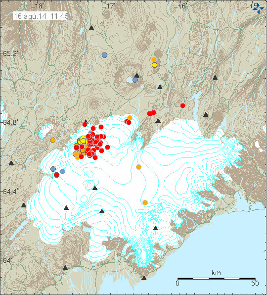
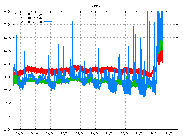
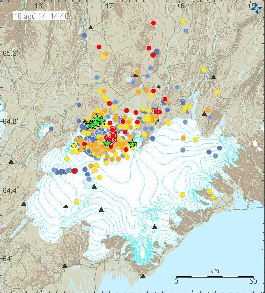
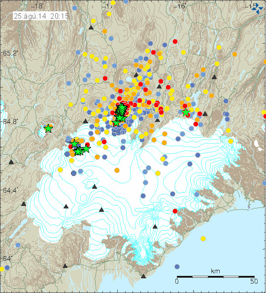
Year 2014.

Bárðarbunga volcano

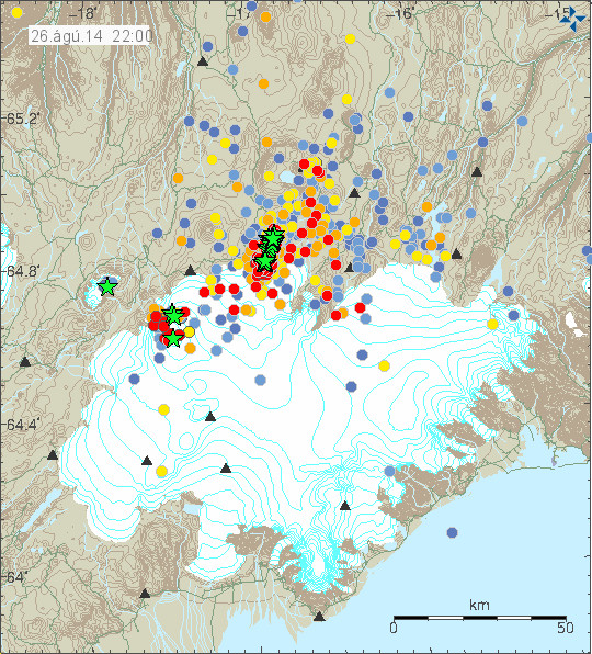
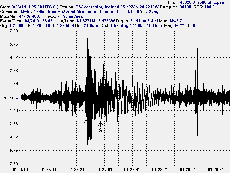
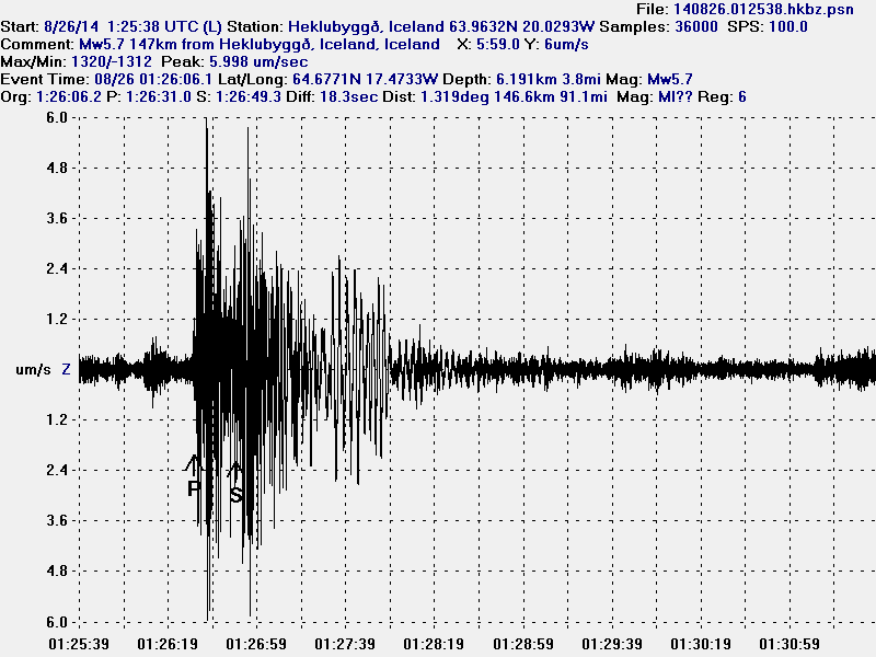
  • Two eruptions in the period of 16 – 22-August-2014. Exact time and date not known at the moment. Each eruption lasted for up to 24 hours at most.
  • Eruption 23-August-2014 under the glacier. Lasted for ~6 hours.
  • Eruption 29-August-2014 in Holuhraun. Lasted for ~4 hours.
  • Eruption 31-August-2014, it ended on 27-Februar-2015. It lasted for almost 6 months.
  • It is not clear how many minor eruptions have taken place under the glacier. Only documented eruptions are mentioned.

Year 2017

Katla volcano.
Start date: 29-July
End date: 29-July

A minor eruption took place in Katla volcano during the night of 29-July. It only lasted for 2 to 3 hours and was not visible and did not break trough the glacier. This eruption was only observed on harmonic tremor data from Icelandic Met office.


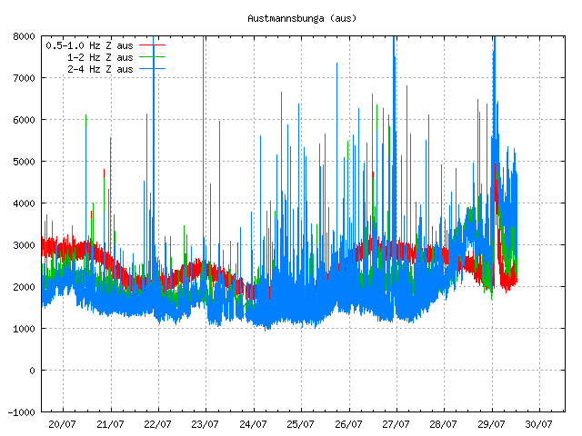
The minor eruption in Katla volcano as it appeared on harmonic tremor data on Icelandic Met Office SIL station. Copyright of this image belongs to Icelandic Met Office.

Before and after this even a small glacier flood appeared in Múlakvísl glacier river that comes from Mýrdalsjökull glacier. That glacier flood ended in the early mornings of 30-July-2017.
——-

This is the list of eruptions so far. It is not free of errors or typos. I am also going to update this list on a later date if I have to. As it is incomplete in regards to number of volcanoes mentioned in him.

Reference.

Eldgosaannáll Íslands (Wiki, Icelandic)
2010 eruptions of Eyjafjallajökull (Wiki)
Ármann Höskuldsson. „Hvert er öflugasta eldgos á Íslandi sem vitað er um?“. Vísindavefurinn 15.10.2010. http://visindavefur.is/?id=57031. (Skoðað 3.4.2011). (Icelandic)

Text is updated at 01:21 UTC on 4. April 2011. Error corrections to the list.
Text updated at 28. June 2011 at 22:34 UTC. Added Grímsfjall volcano eruption to the list.
Text updated at 28 September, 2011 at 12:56 UTC. Added Katla volcano eruption and Hamarinn volcano possible eruption to the list.
Article updated on 24-January-2015 at 00:57 UTC.
Article updated on 03-March-2015 at 15:14 UTC.
Article updated on 10-January-2016 at 19:19 UTC.
Article updated on 04-March-2016 at 03:00 UTC.
Article updated on 04-March-2016 at 03:08 UTC.
Article updated on 30-July-2017 at 20:18 UTC.
Article updated on 3-March-2019 at 00:24 UTC.