Earthquake swarm north of Grindavík town

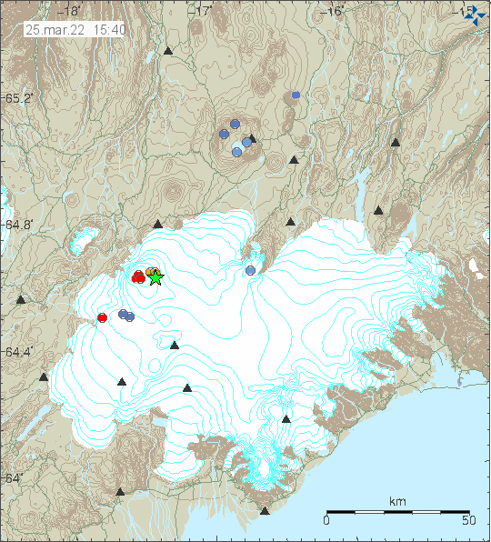
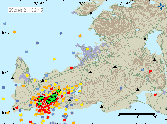
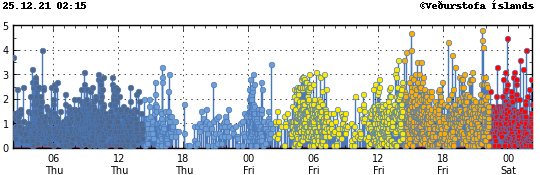
Around 14:00 UTC an earthquake swarm started north of Grindavík town. This look like a tension breaking earthquake swarm and that suggests an inflation is happening again in Fagradalsfjall volcano (mountain). Largest earthquake so far had a magnitude of Mw3,3 and second largest earthquake so far had a magnitude of Mw3,0.

Green star on the map north of Grindavík town shows the main earthquake swarm
Earthquake activity north of Grindavík town. Copyright of this image belongs to Icelandic Met Office.
Red dots north of Grindavík town showing the main area of earthquake activity
Area of earthquake activity. Copyright of this image belongs to Icelandic Met Office.

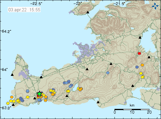
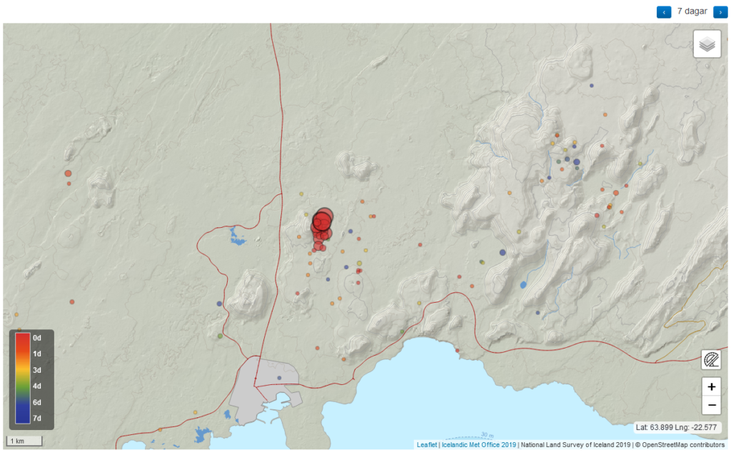
This earthquake swarm is ongoing, but like with all earthquakes swarms in this area it shows a sign of slowing down for few hours before continuing. There is a chance this earthquake swarm might be over. But I am not yet sure if that is the case.

Donations

Since I am broke in April. Please remember to support my work with donations if you can. Thanks for the support. 🙂

Earthquake activity in Bárðarbunga volcano

This morning an earthquake swarm took place in Bárðarbunga volcano. This earthquake activity is because of inflation of Bárðarbunga volcano. Largest earthquake had a magnitude of Mw4,1. Other earthquakes where smaller in magnitude.

Green star in eastern part of Bárðarbunga volcano showing the activity. Few red dots showing smaller earthquakes in western part of Bárðarbunga volcano.
Earthquake activity in Bárðarbunga volcano. Copyright of this image belongs to Icelandic Met Office.

This earthquake activity is normal since the end of the eruption in Bárðarbunga volcano in February 2015 it has been inflating. This earthquake activity is going to change and longer time is going to be between larger earthquakes. This type of earthquake activity is only going to go down to 1 to 2 earthquakes a year in next few years. Then down to one earthquake every few years.

Earthquake swarm in Krýsuvík-Trölladyngja volcano

This morning (17-March-2022) an earthquake swarm took place in Krýsuvík-Trölladyngja volcano.

Green star close to Kleifarvatn lake to the east. Green star shows the strongest earthquake in the area
Earthquake activity in Trölladyngja-Krýsuvík volcano. Copyright of this image belongs to Icelandic Met Office.

Largest earthquake had a magnitude of Mw3,0. Other earthquakes have been smaller in magnitude. Bad weather in last few weeks have prevented good detection of small earthquakes. More earthquake activity might have taken place than appears on Icelandic Met Office maps.

Strong earthquake in Bárðarbunga volcano

At 10:11 UTC today (22-February-2022) an earthquake with magnitude of Mw4,8 (Icelandic Met Office) or Mw5,0 (EMSC) took place in Bárðarbunga volcano.

Two green stars in Bárðarbunga volcano showing the strong earthquake activity in the volcano. Two smaller dots show smaller earthquakes.
Earthquake activity in Bárðarbunga volcano. Copyright of this image belongs to Icelandic Met Office.

Yesterday (21-February-2022) at 14:08 UTC there had been a earthquake with magnitude of Mw3,0 in Bárðarbunga volcano, along with few smaller earthquakes. This earthquake activity shows that Bárðarbunga volcano continues to inflate after the eruption in the year 2014 to 2015. It is impossible to know when next eruption happens in Bárðarbunga volcano, it might be 10 years from now or 100 years from now. Last eruption in Bárðarbunga volcano before the 2014 eruption was in the year 1902.

Donations

Please remember to support my work with donations. They help me from not being broke. Thanks for the support. 🙂

Strong earthquake activity in Katla volcano

At 19:10 UTC today (02-February-2022) an strong earthquake swarm started in Katla volcano. Strongest earthquakes so far had a magnitude of Mw4,0 (19:10 UTC) and Mw3,4 (19:44 UTC).

Earthquake activity in Katla volcano. A lot of red dots with two green stars on the calder rim
Earthquake activity in Katla volcano. Copyright of this image belongs to Icelandic Met Office.

At the writing of this article it is unclear if this is going to result in an eruption. The chances are good, but this activity might still slow down and stop before any eruption, small or large happens in Katla volcano.

This article is going to be updated if needed or new article is going to be written if the situation changes enough from what it is now.

Magma on its way up the crust in Fagradalsfjall mountain, last measurements shows 1600 meters left (1,6km)

According to a news on Vísir.is (linked below) the magma has started to rise in Fagradalsfjall mountain. At the time of the measurement from a satellite the magma had around 1600 meters (1,6km) left until it reached the surface. At the speed the magma was travelling, around 130 meters a day an eruption was expected to happen around 11-January-2022. This is the current estimate, but that might change of the magma increases or slows down the speed it is going up in the crust.

It is unclear what area is going to erupt since the new dyke is more alongside the older eruption dyke. There is more chance than less that new craters are going to open up and start erupting, some of the area is under fresh lava from earlier eruption. Making the area look interesting when this eruption starts.

Icelandic News

Kvikan á uppleið en á enn 1.600 metra eftir (Vísir.is)

Strong earthquake activity in Fagradalsfjall mountain, Krýsuvík-Trölladyngja volcano

This information is going to get outdated quickly.

There is now a constant earthquake swarm activity in Fagradalsfjall mountain, part of the Krýsuvík-Trölladyngja volcano system. More than a dozen of earthquakes have been larger than magnitude 4,0 and it doesn’t look like this earthquake activity is doing to stop soon. Largest earthquakes in last few hours had a magnitude of Mw4,8 and Mw4,5. The earthquake north of Grindavík town appears to be a tension breaking earthquakes because of magma inflation in Fagradalsfjall mountain.

A lot of earthquakes on Reykjanes peninsula, more than a dozen green stars, hundres of red dots showing smaller earthquakes
The earthquake activity on Reykjanes peninsula. Copyright of this image belongs to Icelandic Met Office.
Heavy earthquake activity shown on Icelandic Met Office earthquake tracker. The density of earthquake activity has the image swamped with activity
Earthquake activity on Reykjanes peninsula in Fagradalsfjall mountain for the last 48 hours. Copyright of this image belongs to Icelandic Met Office.

This earthquake swarm is close to Grindavík town, this is a similar situation that happened earlier in the year 2021. Just before the eruption in Fagradalsfjall mountain. This earthquake activity is going to continue to grow until an eruption starts. This earthquake activity also happens in a wave, resulting in it lower earthquake activity between powerful earthquake activity. I am expecting more strong earthquakes in next few days, unless an eruption starts in Fagradalsfjall mountain or nearby area.

Update on activity in Krýsuvík-Trölladyngja volcano in Fagradalsfjall mountain, eruption is going to happen soon

Information here are going to get outdated quickly.

The earthquake activity in Fagradalsfjall mountain continued on 22-December and on 23-December-2021. Largest earthquake in last few hours had a magnitude of Mw4,9 and was felt over a wide area. No property damage has yet happened because of this earthquake activity so far.
There are now three centres where the earthquake activity is happening. The first one is north of the large crater, the second one is under the main crater and the third one is in Nátthagakrika (about south-west of the large crater). This is the area where people used to walk up the eruption on walking paths A and B.

Dense earthquake activity on Reykjanes pensiula with lot of earthquakes and green stars and red dots
The heavy earthquake activity on Reykjanes peninsula. Copyright of this image belongs to Icelandic Met Office.
Plot showing the magnitudes of the earthquake and density. A lot of earthquake that go above 3 line and dense dots with smaller magnitudes
The density of the earthquake activity in the current earthquake swarm. Copyright of this image belongs to Icelandic Met Office.

This earthquake activity is not going to stop until an eruption starts. When that happens is not possible to know. If a new crater opens up that is going to result in ever growing and stronger earthquakes. If the crater that is already in place starts erupting again, that is going to result in some earthquake activity. What is known is that the magma is going to go the path of least resistance, whatever that path might be. At the writing of this article, over 6000 earthquakes have been recorded and around 50 to 100 of them have been larger than magnitude 3,0.