Magma on the move in El Hierro, Canary Islands

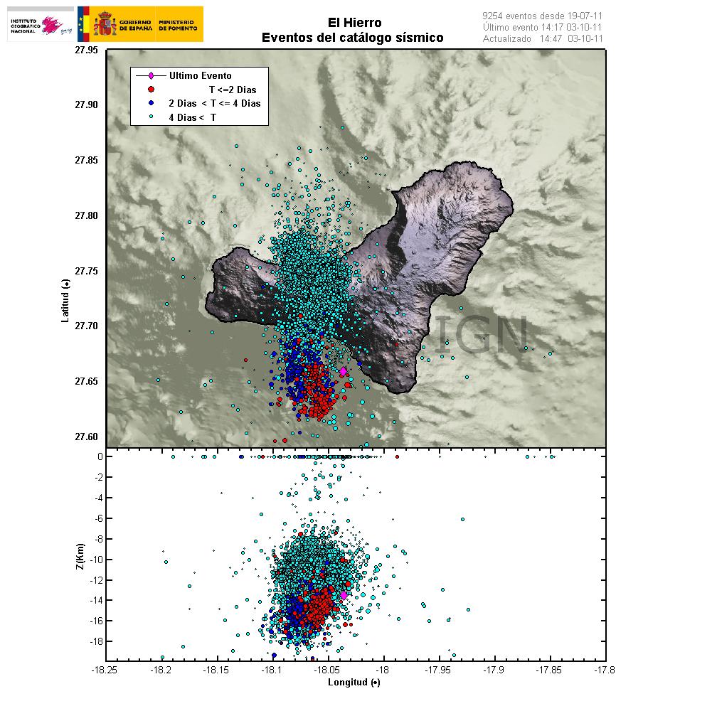
This is happening faster then I expected. But it seems that magma is now on the move upwards in El Hierro volcano in Canary Islands. This is evident by the earthquake patterns that are emerging from the volcano. Given the earthquake locations, most likely place for a eruption to take place is out on the ocean based on that. But sometimes magma can find different pathways up the surface without a lot of warning.


Latest earthquake map from Instituto Geográfico Nacional that shows clearly the earthquake pattern since the dike intrusion did start in El Hierro. Copyright of this picture belongs to Instituto Geográfico Nacional.

At the moment it is impossible to know when and where a eruption might start. It depends on many factors. But it is now clear that magma is on the move upwards. So far the magma seems to be around 10 km up in the earth crust under El Hierro. So it is clear that the magma is on the way up and most likely preparing for a eruption.

What is happening in El Hierro volcano

This is a special blog post about the volcano El Hierro in the Canary Islands. The resons for this blog posts are those that this activity is interesting and there is not a lot happening at the moment in Iceland due to bad weather (nothing gets recorded in this bad weather).

Currently El Hierro volcano is a phase that I personally call a magma intrusion phase (I have no other word for it). But that means that magma is currently coming from a depth, that is more then 20 km below the volcano and up the crust directly below the volcano. It is impossible to know how long this phase is going to last. As a example this phase for Eyjafjallajökull volcano lasted for good part of 17 years (with some breaks). When the pressure is high enough in the sill that is now forming in El Hierro the magma is going to break up the surface.

This pattern can clearly be seen on this image here.
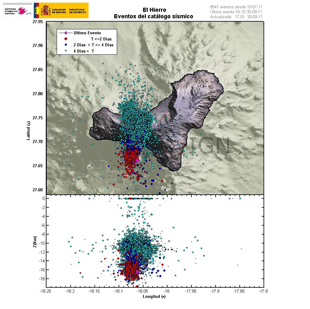

The magma is flowing up into the volcano at around 30 degree angle from the depth of more then 20 km. When a new magma injection starts, a new earthquake swarm starts in El Hierro. This magma injections are different in size and length. But as more magma collects into the bedrock in El Hierro the stronger earthquakes are going to take place. But this increases the pressure on the rock and inside the magma chamber that is now forming and can clearly been seen with the earthquake pattern. Copyright of this picture belongs to Instituto Geográfico Nacional.

I did see a picture that was made on Eruptions blog that did show his clearly, both the feeder channel of the magma and the magma chamber that is currently in the making. It seems that magma inflow into the new magma chamber or the sill in El Hierro is stable at the moment. But I base that view on the constant earthquakes that are currently taking place. But this magma inflow seems to have been stable since 16 July, 2011 when the magma started to push upwards into El Hierro.

Earthquakes that signal new inflow of magma do not need to be strong in size. But they are deep, with the most depth around 20 km. But the crust in this area is around 10 to 26 km thick. As this is a ocean crust in this area. But the Canary islands are the thickest crustal part in the area. But it is also important to notice that the magma chamber or the sill is expanding in all directions, not just upwards. That in it self is also going to create deep earthquakes. But those earthquakes should remain a bit outside the main area of the deep earthquakes that are currently taking place in the area.

I am expecting a lot more earthquake activity when or if El Hierro starts erupting. But when that might happen impossible to know for the moment. The only thing that can be done is too wait and see what happens.

Update 1: Here is the earthquake activity for today (30 September, 2011).
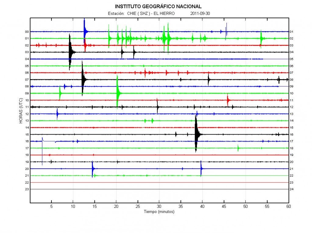

Earthquake activity of today (30 September, 2011). There is less earthquake activity today. This happens when magma flows into a volcano. This did also happen with Eyjafjallajökull volcano in the year 2010. If anyone has the direct link too this plot, please leave it in the comments. Thanks. Copyright of this picture belongs to Instituto Geográfico Nacional.

Update 2: Links too El Hierro information can be found here.

Update 3: The Spanish news channel Canal 24 can be found here and it is live.

Update 4: Here is a news in english about the evacuation of El Hierro. It is from 28 September, 2011. Evacuation of El Hierro begins as fears of volcanic eruption grow. Thanks to Dr. John v. Kampen that did send this to me with a email.

Note: There are new pictures of Eyjafjallajökull volcano, Fimmvörðuháls craters here. They show the difference from the year 2010 and in the year 2011. The text is in Icelandic.

Also. Please support my effort so I can buy two new geophones and add them to my monitoring network in Iceland. Thanks! 🙂

Blog post has been updated 30 September, 2011 at 22:12 UTC.
Blog post has been updated 30 September, 2011 at 22:25 UTC.
Blog post has been updated 30 September, 2011 at 23:08 UTC.
Blog post has been updated 1 October, 2011 at 14:48 UTC.
Special report: Part of Japan moved 4 meters due to the Mw9.0 earthquake

According to BBC News it seems that that part of Japan moved up to 4 meters in the Mw9.0 earthquake. Closest to the epicentre of the earthquake the movement is possibly up to 20 meters, but the movement might have not been all the same within the fault line (100 wide and 500 km long). This earthquake might also have shifted the Earth axis about 16.5 cm. But this earthquake has also changed the sea bead in such way that it needs to be remapped for ships.

Two videos of the earthquake.

BBC News on this.

How the quake has moved Japan (BBC News)
Pictures of the damage from the earthquake (BBC News)

Support Japan and it’s population with donations.

2011 Japanese Earthquake and Tsunami
(Google Information web page)

Special report: Pre-earthquakes to the Mw8.9 earthquake in Japan

It appears that before the large earthquake that did happen today (11th March 2011) there was a sequence of a pre-earthquakes. The pre-earthquake to the large Mw8.9 earthquake was a Mw7.2 (EMSC data) that took place on the 9th March 2011 at 02:45 UTC. This pre-earthquake was followed by about dozen or so aftershocks, the largest one being Mb6.2 (EMSC data).

The problem with this type of pre-earthquakes is that you cannot know that they are pre-earthquakes until after the large earthquake takes place. Because of that fact, it is only now known that the Mw7.2 was a pre-earthquake to the Mw8.9 earthquake that did hit Japan today (11th March 2011).

Please see BBC News or CNN for more news about this earthquake.

For webicorders that show the earthquake can be found here. USGS webicorders can be found here.

Special report: A Magnitude Mw8.9 earthquake struck Japan

At 05:46 UTC (14:46 local time) there was a Mw8.9 (or up to Mw9.1, it is hard to terminate the exact size of this large earthquakes right away) earthquake in Japan. The depth of this earthquake was registered 24 km depth. But that is the reason why this earthquake did create this big tsunami. According to news there has been great damage following this earthquake. Loss of human lives following this earthquakes is also feared. But already there have been found bodies of 300 people that died following this earthquake. After the earthquake a huge whirlpool was created according to BBC News, a video of it can be seen here.

The rupture zone is estimated to be about 500 km (EMSC). But that number might change on a later date. A lot of aftershocks have followed the main earthquake. The largest aftershock did reach Mw7.0 in size so far. But there have also been a lot of earthquakes that have magnitude Mb6.0 – Mb6.9. Many more aftershocks of size Mb5.0 – Mb5.9 have also happened. I have no information about smaller aftershocks. But I am going assume that the number of earthquakes in smaller range is in the number tens of thousands.

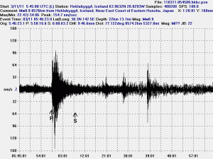
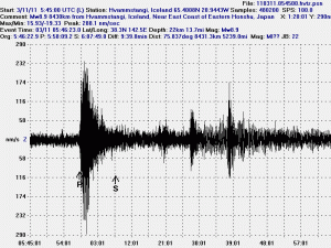
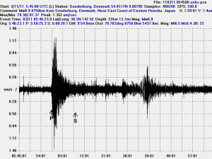
This earthquake was recored on all my geophones. Even the one that I have here in Denmark on the second floor where I live.

Above: The Mw8.9 earthquake in Japan on Heklubyggð (Iceland) geophone. This picture is under CC licence.

Above: The Mw8.9 earthquake in Japan on Hvammstangi (Iceland) geophone. This picture is under CC licence.

Above: The Mw8.9 earthquake in Japan on Sønderborg (Denmark) geophone. This picture is under CC licence.

I am going to post more information about this earthquake when I have them. I am also going to post more information about the aftershocks later on.

Please check all major news networks for news about this earthquake.