Waiting for the eastern Skaftá glacier cauldron

The glacier flood in Skaftá glacier river is almost over or is over at present time (21-January-2014). This however does not mean that everything is over. Since there are two cauldrons in the Vatnajökull glacier in the Hamarinn volcano it means there is more water stored there now then has now flooded from the glacier. It is now clear that the eastern Skaftá glacier cauldron in Vatnajökull glacier has not emptied it self in this flood from the western Skaftá glacier cauldron.

skaftarkatlar.svd.19-Januar-2014
The eastern (Eystri) and western (Vestari) cauldrons in Vatnajökull glacier. Copyright of this image belongs to Icelandic Meteorological Office.

When the eastern glacier cauldron empties it self they are expecting a lot larger glacier flood to take place. Since there is a lot more water holding up in the eastern Skaftá glacier cauldron. It is also longer since it flooded and emptied it self. Last glacier flood from the eastern Skaftá glacier cauldron was in the year 2010. More information on how this flood system works can be found here (in Icelandic) on Icelandic university website geology department.

Glacier flood started in Skaftár glacier river

It was announced today (19-January-2014) that glacier flood has started in Skaftá glacier river (or connected rivers) from Skjaftár cauldrons in Vatnajökull glacier. Currently the water is discharging from Skaftár cauldrons at the rate of 370 m3/s according to Icelandic Meteorological Office. So far no changes have taken place in harmonic tremors close to Hamarinn volcano where the Skaftár cauldrons lie within Vatnajökull glacier.

Smell of hydrogen sulphide has been detected by people living close the rivers that the glacier flood is discharging into. There is a considerable risk of poisoning if people get to close the rivers that hold the flood water. It is currently believed that it is the western Skaftár cauldron that is now emptying, that one did empty it self back the in the year 2012. That is however not going to be confirmed until the area can be checked by flying over it and see what is taking place at this location. That might take few days since it is dependent on weather when it is possible to do such flight.
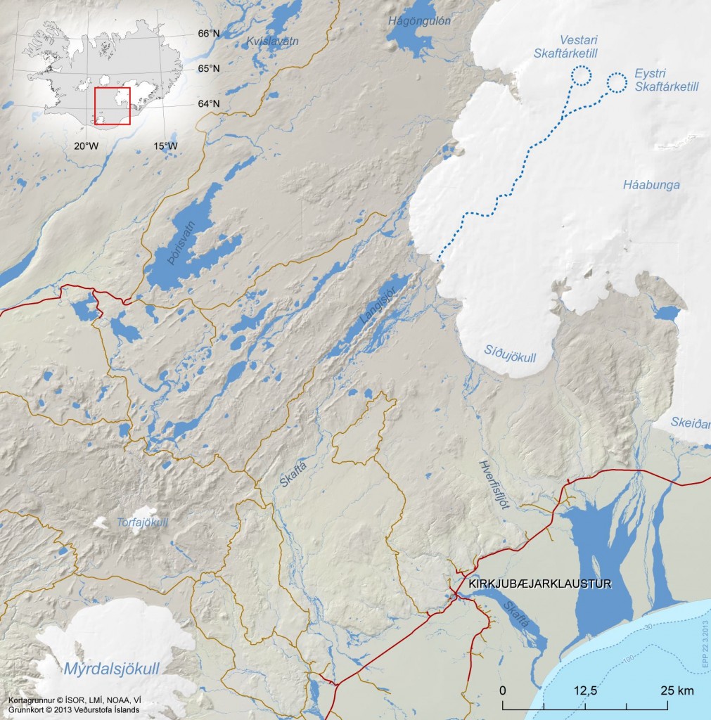
skaftarkatlar.svd.19-Januar-2014
Location of Skaftár cauldrons in Vatnajökull glacier. Copyright of this image belongs to Icelandic Meteorological Office. Picture is taken from Icelandic Meteorological Office Facebook page.
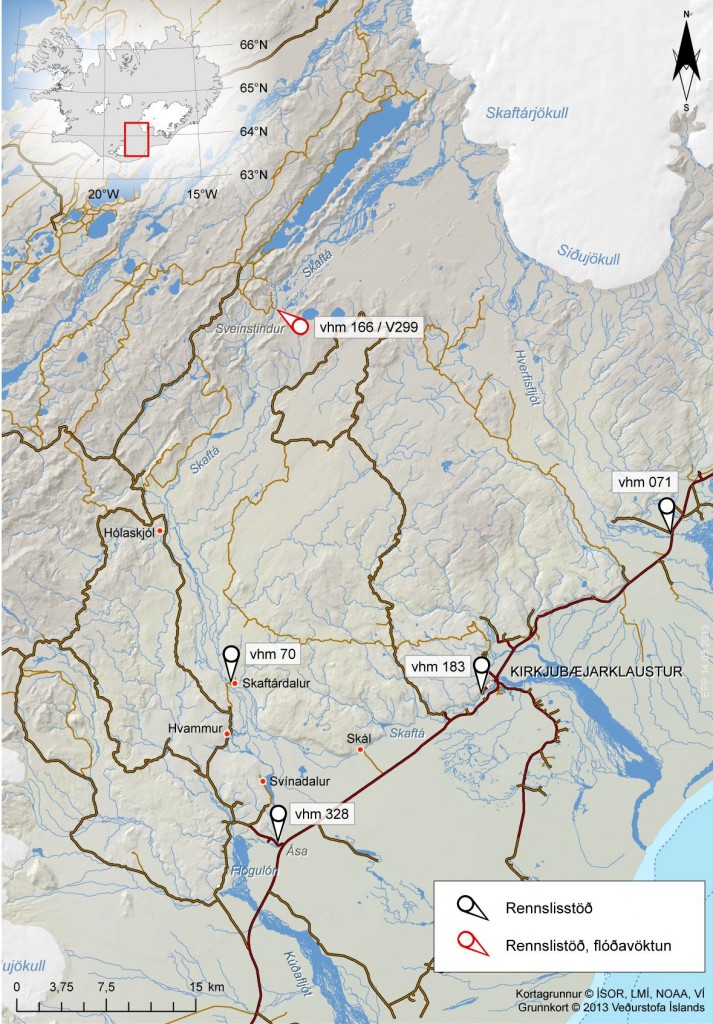
skaftarkaltar.rennsli.svd.19-Januar-2014
The current flood in Skaftár glacier river. The water monitoring stations around Vatnajökull glacier. Red stations are monitored for floods, black ones are normal flow stations. Copyright of this image belongs to Icelandic Meteorological Office. Picture is taken from Icelandic Meteorological Office Facebook page.

Uncertainty level has been declared in the area do to this glacier flood by the Civil Protection and Emergency Management in Iceland. It is advised against people travelling in the area while this glacier flood takes place. On Vatnajökull glacier there is also a risk of new cracks forming in the glacier was the cauldron is emptied of water in the next few days. This cracks are dangerous and really deep and wide on the top, but get narrower closer to the end of them. It is possible to monitor the glacier flood here on Icelandic Meteorological Office website.

Icelandic news about this. Some English text is in some of the news. It is possible to use Google Translate on this, but result can be unreliable.

Skaftárhlaup er mjög líklega hafið (Rúv.is, maps, English text)
Skaftárhlaup hafið en það vex óvenju hægt (Rúv.is, Icelandic, maps)
Óvissustig vegna Skaftárhlaups (Rúv.is, Icelandic, maps)

Skaftárhlaup er hafið (mbl.is, English text)
Óvissustig vegna Skaftárhlaups (mbl.is, Icelandic)
Fundað um næstu skref (mbl.is, Icelandic)

Post updated at 20:34 UTC on 19-January-2014.

Conductivity spike in Skjálftandafljót glacier river

Last week there was an conductivity spike in Skjálfandarfljót glacier river. It is not clear what did create this conductivity spike that was detected and it’s unknown what volcano or hydrothermal area was leaking water into the river. No glacier flood did follow this spike and no extra activity was detected following this. This conductivity spike was detected on the Thursday 22-November-2013 at 20:20 UTC.

Harmonic tremor detected in Þórðarhyrna volcano

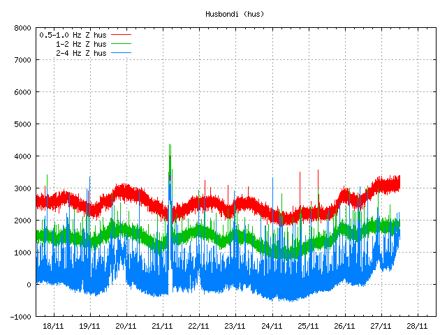
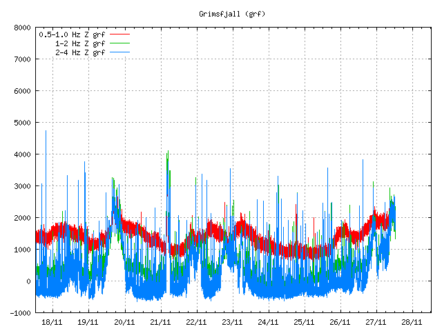
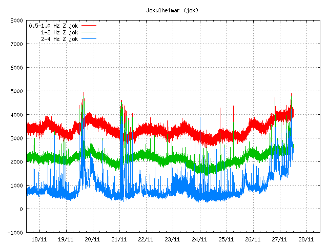
On the 21-November-2013 there was an earthquake swarm in Þórðarhyrna volcano (part of Grímsfjall volcano). This was not large earthquake swarm or a strong one. With the largest earthquake just having the magnitude of 1,9. While I did just suspect it I did not have it confirmed until today that following this earthquake swarm was an harmonic tremor pulse. This harmonic tremor lasted from 03:30 to 06:10 UTC. Based on nearby SIL station this was not a strong harmonic tremor, but this is important because it suggests that something is taking place in Þórðarhyrna volcano. If this is going to lead to an eruption is unknown at current time. This might be a dike intrusion into the volcano at depth, but that has not been confirmed.

hus.oroi.svd.27-November-2013
The harmonic tremor pulse can be seen at 21-November date on this tremor plot from Icelandic Meteorological Office. Copyright of this image belongs to Icelandic Meteorological Office.

grf.oroi.svd.27-November-2013
The harmonic tremor pulse as it did appear from Grímsfjall SIL station. Copyright of this image belongs to Icelandic Meteorological Office.

jok.oroi.svd.27-November-2013
Harmonic tremor pulse as it did appear on Jökulsel SIL station. Copyright of this image belongs to Icelandic Meteorological Office.

This activity might not lead to an eruption, but given the past history of this area and the eruption in Grímsfjall volcano in the spring of 2011 I find it to be highly likely outcome that eruption is going to take place in Þórðarhyrna volcano in near future, it is not possible to know when such eruption might take place. Last eruption took place in Þórðarhyrna volcano in the year 1902, it is not known if any later eruptions have taken place in Þórðarhyrna volcano.

Blog post updated at 14:47 UTC.

Minor dike intrusion into Bárðarbunga – Hamarinn volcanoes

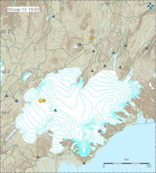
It seems that yesterday (02-September-2013) a minor dike intrusion took place in Bárðarbunga – Hamarinn volcanoes. This created an minor harmonic tremor yesterday on nearby sil stations. There were earthquakes following this events, the strongest one had the magnitude of 2.8 at the depth of 14 km. A second earthquake with the magnitude of 2.1 took place few moments later, it had the depth of 15.5 km. Only one smaller earthquake have seen taken place in this area of Bárðarbunga – Hamarinn volcanoes.

130903_1920
The earthquake activity in Báðarbunga – Hamarinn volcano area. Copyright of this image belongs to Icelandic Meteorological Office.

It is important to notice that dike intrusions are common in this area, often happen many times a year. How many takes place can vary between years. That dike intrusion took place does not mean an eruption is going to take place. It just means that magma moved, what that means for the future is unknown at present time.

Donations: It would be nice if people donated so that I can buy food this month. In other case I am going to have to eat really little this month and I am not happy about such things taking place.

Blog post updated at 21:43 UTC on 3-September-2013.

Interesting harmonic signals appearing around Vatnajökull glacier

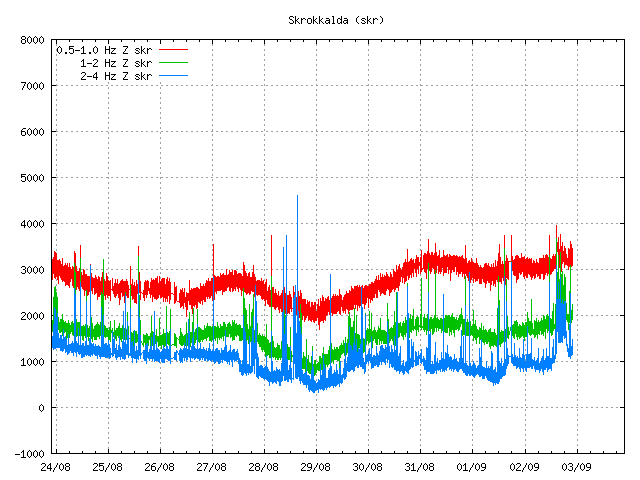
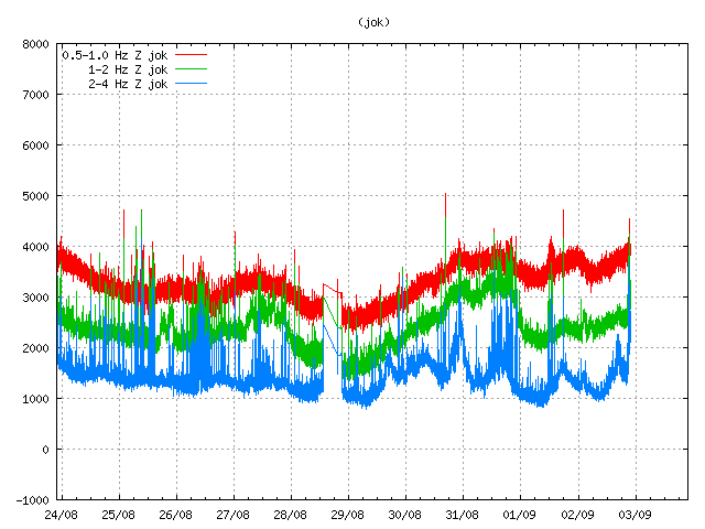
In the past few hours an interesting harmonic signals have been taking place on two sil stations (so far) around Vatnajökull glacier. I do not know what is creating this harmonic tremor spikes on them, it might be water on the move or starting to move from Skaftár cauldron in Vatnajökull glacier or it might be something different that I do not know about at present time. Currently the source of this harmonic tremor is unknown and it might never been known in the worst case. I do hope to figure out in next few hours what is creating this harmonic tremor spikes on this two sil stations.

skr.svd.02-September-2013.22.00.utc
The harmonic tremor signal at Skrokkalda sil station. The harmonic tremor signal can be found at the end of the tremor plot. Copyright of this image belongs to Icelandic Meteorological Office.

jok.svd.02-September-2013.22.01.utc
The harmonic tremor signal at Jökulsel sil station. It is at the end of the tremor plot. Copyright of this image belongs to Icelandic Meteorological Office.

As I say above, the source of this tremor signal is not known. It might be bad weather in the area, traffic (unlikely due to bad weather in this part of Iceland at the moment) or something that is not known at the moment. What I can rule out at the moment is this harmonic tremor signal does not appear to come from magma movement, the frequency of the harmonic tremor is too high for that at the moment and does not show little to no energy at 0.5 to 1 Hz band. This suggest the source is something else then magma, this however does not rule out magma. Since magma is known to due many strange things under pressure and high frequency harmonic tremors are not unknown, but they are unlikely to take place rather than being a common feature in volcano activity.

For the moment the best thing that can be done is to monitor the signal and see if there are any changes and on the nearby sil stations. For the moment I do not expect any major change in this area, risk of glacier flood is still in place for this part of Vatnajökull glacier. If this harmonic tremor signal connects to that is not known at the moment.

Possible glacier flood from Skaftár cauldron

It is possible that glacier flood from Skaftákötlum cauldron has started some hours ago. According to Rúv, Icelandic Meteorological Office is now monitoring for signs that glacier flood has started. Changes in conductivity in glacier rives from Vatnajökull glacier (South-West) and the rivers that normally flood from Skaftárkötlum cauldron. It has not been confirmed that glacier flood has started yet.

At the moment it has not been confirmed that glacier flood has started, but it might start soon. I am going to post more information once I have them or when they are published.

Icelandic News about this

Fylgjast náið með Skaftárhlaupi (Rúv.is)

Skaftárkatlar cauldrons full of water [Updated]

According to recent pictures and from Rúv News it appears that both Skaftárkatlar cauldrons are full of water at the moment. They might burst at any moment and create glacier flood, the right cauldron has not flooded for the past three years according to Rúv News, while the left cauldron flooded last year. When they might flood is impossible to know, but it is expected to happen in next days to weeks.

Update 1: Icelandic Meteorological Office has now declared that Skaftárhlaup glacier flood is going to happen soon. A glacier flood can start at any time without warning. The risk comes from gases in the water, along with the floodwater it self as it can reach up to 1500 m3 at peaks levels. There is also a risk the flood might go into new rivers and those rivers has bridges that might not be able withstand such glacier flood.

Details in Rúv News

Mikið vatn í eystri Skaftárkatli (Rúv.is, pictures)
Video of the Skaftárkatlar cauldrons in Vatnajökull glacier.

Skaftárhlaup vofir yfir og skapar hættu (Rúv.is, Icelandic)

Information in Icelandic from Icelandic Meteorological Office

Yfirvofandi Skaftárhlaup og möguleikar á hlaupi í Hverfisfljóti (vedur.is, Icelandic)

Blog post updated at 18:04 UTC on 14-August-2013.
Blog post updated at 19:04 UTC on 14-August-2013.

Melting of glaciers in Iceland might mean more volcano activity

In the evening news on Rúv tonight (23-July-2013) a interesting report about possible future volcano activity was being reported. A unpublished paper (according to Rúv News) reports that with more glacier melt in Iceland, more eruptions should be expected to take place. This is mostly true about areas like Vatnajökull glacier, as it holds several volcanoes that are under heavy pressure from the glacier ice. This applies mostly to volcanoes like Grímsfjall volcano, Bárðarbunga volcano and Kverkfjöll volcano, but those three volcano are the largest ones in Vatnajökull glacier.

This might also apply to areas like Mýrdalsjökull glacier. If this study is true, there might be more eruptions in Iceland in next few decades as the glacier melts away. This like so many other things, is however something that is just wait and see seranio.

At the moment, everything is quiet in Iceland when it comes to activity in volcanoes and on fault zones in Iceland.

Rúv News about this

Auknar líkur á eldvirkni með bráðnun jökla (Rúv.is, Icelandic, video)

Increased monitoring for volcanoes in Vatnajökull glacier

I did see a short news about increased monitoring for volcanoes (you have zoom in manually, the new web page is a mess and not highly useful as such in my view) in Vatnajökull glacier.

Two new seismometer have been added to the SIL network in Vatnajökull glacier. Making detection of activity in Öræfajökull, Grímsfjall, Bárðarbunga, Esjufjöll and other volcanoes easier and more sensitive. It is going to be interesting to see what this information this new seismometer bring to light when it comes to activity in Vatnajökull glacier volcanoes.

Icelandic news about this

Vatnajökull undir nánara eftirliti en áður (Vísir.is)