Icelandic Met Office adds new seismometers on Snæfellsnes peninsula

On Friday (2-October-2020) Icelandic Met Office announced on their Facebook page that they had added three new seismometers. This means that on the Icelandic Met Office Iceland map there are now going to start appearing earthquakes on Snæfellsnes peninsula and earthquakes when they happen in Westfjörd and other nearby areas out in the ocean and on land. Areas that have until now not had great detection of small earthquakes. This are just three seismometers so locations might be slightly inaccurate for the smallest earthquakes. But this is the first time that Snæfellsnes peninsula is being monitored all day directly. I don’t know where the new seismometers are located since they are not yet on the tremor plot website that Icelandic Met Office has.

The new seismometers on Snæfellsnes peninsula are going to show earthquakes if any from this volcanoes that are on Snæfellsnes peninsula.

Snæfellsjökull volcano
Ljósufjöll volcano
Helgrindur volcano

Thieves stealing batteries from remote monitoring stations in Iceland

I did see in Rúv News today that thieves are now stealing batteries from scientists remote monitoring stations, this are the stations that monitor volcanoes, earthquake activity, GPS data and more. Each theft cost around 3 to 5 million ISK (damage to hardware), data is also being lost. Along with other hardware damage that happens when the batteries are removed forcefully from the hardware.

This theft prevents important measurements on active volcanoes in Iceland, that can prevent important measurements of a volcano if something is taking place in it. Theft has happened on monitoring station in Krísuvík volcano and Eyjafjallajökull volcano, not long time ago (about 3 weeks) a battery was removed from both places. It is important if people come across this hardware to just leave it be, it is important to monitoring active volcanoes in Iceland and damage cost money, lost data and even important signs of eruption in worst case.

So if you come across monitoring hardware in Icelandic nature. Leave it at peace!

Icelandic News about this

Stela rafgeymum vísindamanna (Rúv.is)

Blog post updated at 17:25 UTC on 16-June-2013.
Blog post updated at 18:55 UTC on 16-June-2013.

Weather has been problem for monitoring instruments on Mýrdalsjökull glacier this winter

Bad weather has been a major problems for monitoring Katla volcano (and others also) this winter in Iceland. Not only has the bad weather damaged communications setup for the instruments in question. But also has a lot of snowfall prevented solar chargers and windmills that generate power for this instruments made them fail. In many cases the instruments them self are also under several meters of snow in few cases.

This means that for long periods during this winter there have been no data recorded on several SIL stations on Mýrdalsjökull glacier. But last week technicians from Icelandic Meteorological Office and University of Iceland did go up to Mýrdalsjökull glacier to try and fix the broken instruments and hardware in question. They had some success. But have to return later to repair the hardware they where not able to repair this time around.

Icelandic news about this repair mission can be found here. This news is in Icelandic.

Mýrdalsjökull leikur mælitæki grátt (Rúv.is, Icelandic)
Fréttir: Jökullinn leikur mælitæki grátt (Icelandic, Video)

Two SIL stations have failed during winter on Mýrdalsjökull glacier

During a rather harsh winter in Iceland. Two SIL stations have failed on top of Mýrdalsjökull glacier. This are the SIL stations Austmannsbunga and Etnu glacier (local name). The reason for the failure is ice that loaded on to the mast the SIL stations. Making it fall down on the ground. Therefor making the SIL stations lost contact with Icelandic Meteorological Office and University of Iceland. University of Iceland and Icelandic Meteorological Office plan a trip soon to this area of Mýrdalsjökull glacier too fix this SIL stations that are broken. But the weather has too improve first in Iceland before that can happen.

I also suspect this is the problem with the SIL stations on Vatnajökull glacier. That SIL station just has the term “vot“.

Icelandic news about this weather related failure

Skjálftamælir á Mýrdalsjökli óvirkur (Rúv.is)

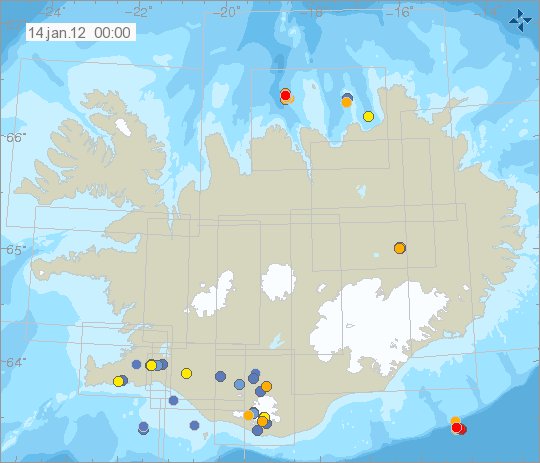
Earthquakes about 88 km south of Höfn í Hornarfirði

Earlier tonight an earthquake swarm started around 88 km south of a town of Höfn í Hornarfirði. This area last had an earthquake or earthquake swarm in Week 22 (no map exist of it, but the earthquakes are in the weekly overview list) in the year 2007. Then the largest earthquake was around ML3.0 in size.

So far the largest earthquake has been around ML2.3 in size, with the depth of 9.4 km. But the earthquakes that are detected around ML2.0 in size. But given the distance from the SIL network. This size is the lowest size that can be detected from what I can tell. This is because of the distance from the closest SIL station and how few SIL stations are in this area that are able to detect earthquakes this far out in the ocean. Earthquakes like this regularly happen all around Iceland. But most are not detected due to lack of SIL stations in the area. For that reason it is impossible to know for sure how many earthquakes actually have taken place there, as the SIL network is only recording the largest ones in this area.


The area where this earthquake swarm is taking place is on the edge of Iceland volcanic shelf. This is often refereed to as intra-plate earthquakes. Copyright of this picture belongs to Iceland Meteorological Office.

This area is not volcanic last I knew. As it has no-known volcanoes today and most likely never has had any active volcanoes. In this area the Iceland plate is pushing down the oceanic crust that is on top of. This progress often creates earthquakes as we are now seeing. I have not yet found any research paper, as I am unsure what terms to use to look for the research.

Iceland government to increase monitoring and research into Iceland volcanoes

Iceland government did approve today to increase funding for research into Iceland volcanoes. But this is also part of a plan for a risk assessment for volcanoes in Iceland. But it is expected that this research is going to take 15 to 20 years. Funding has already been increased to Icelandic Met Office by grands from ICAO (among other I think, but I do not have it confirmed). But this is a direct response to the fact that Eyjafjallajökull volcano and Grímsfjall volcano have erupted in short time span (11 months apart).

But the Icelandic government is expecting a eruption in Grímsfjall volcano every two to seven years. But it is also expecting eruptions in Bárðarbunga volcano following this increased activity in Grímsfjall volcano. But eruption period often follow in Bárðarbunga volcano when activity increases in Grímsfjall volcano.

First step of this research is going to take three years to finish. But the news does not say what they are going to cover in this research. This risk assessment is done by the standards of U.N and WMO.

Icelandic News about this.

Hefja vinnu við hættumat fyrir eldgos – tekur 15 til 20 ár í heildina (Vísir.is, Icelandic)

Background noise compared to a eruption and other events

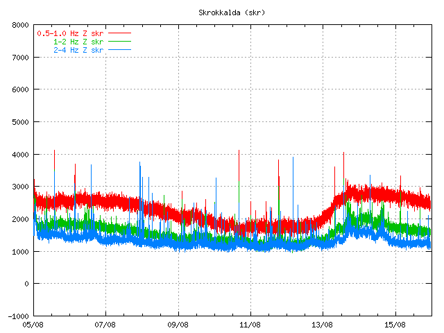
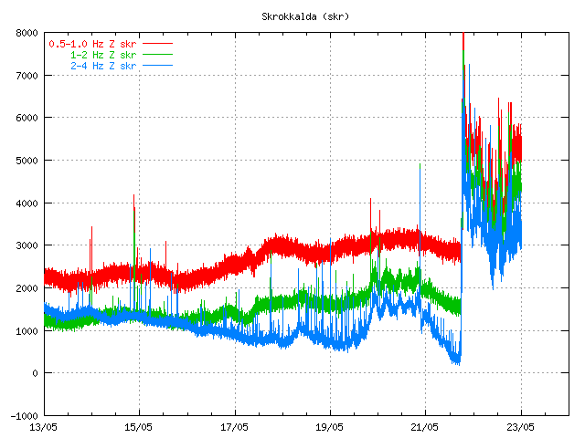
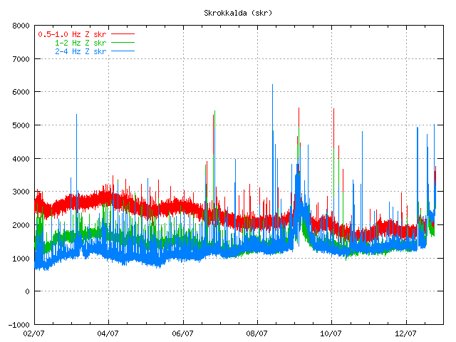
Here are few examples of how the tremor plots looks like if anything important is going on in Iceland.


Normal quiet tremor plot. Few earthquakes create spikes on it. But besides that everything is quiet. Copyright of this pictures belongs to Icelandic Met Office.


This is from the Grímsfjall volcano eruption in May 2011. On this tremor plot it can be clearly seen how much noise a eruption actually makes. The background noise just goes away soon as there is something going on. Copyright of this pictures belongs to Icelandic Met Office.


This is Skrokkalda SIL stastion on 12 July 2011. It can clearly be seen where the harmonic tremor goes above the background noise. Copyright of this pictures belongs to Icelandic Met Office.

It is quite clear. Besides earthquakes and some harmonic tremors that are different then this signals that I have shown here. Unless you see this on Icelandic Met Office tremor plot you can be sure that it is quiet in Iceland. Volcano eruptions make a lot of noise when they are ongoing, even the small eruptions make some noise that can be detected by the SIL network in Iceland.

Note: I might update this blog post on later date and put in more examples about the difference between background noise and a eruption.

General overview of Grímsvötn eruption on 23. May 2011 at 20:33 UTC

This is a general overview of Grímsvötn eruption on 23. May 2011 at 20:33 UTC.

Ash cloud: The ash cloud is still going strong. It is however a bit lower then in first few days. Measurements of the ash plume now says that it is between 5 to 9 km. Because of that it does not appear on the radar at IMO. The ash cloud has now been detected all over Iceland, except for the most western part of Iceland (Westfjod). In the areas closest to the main ash cloud the visibility is from 1 meter and up to 500 meters when it is at it’s best. Ash fall is expected to last for the next few days, or until the crater does not get any water into it to make the ash. The ash cloud is expected to reach Scotland tonight (Rúv, Icelandic). BBC News about cancelled flights due the ash cloud. Farmers live stock has started to die due to the ash cloud. It is unknown how the wild life is doing while the ash cloud covers part of south Iceland. Current output of the Grímsfjall volcano is about 1000 to 2000 tons of ash pr second. It was around 10,000 tons of ash pr second during the first days of the eruption.

Rúv News, Öskufall næstu daga (Icelandic, Rúv.is)

Eruption: Even if the ash cloud is lower now. It appears that the eruption is still going strong. In the evening news at Rúv it was reported that there was a chance the magma that powers this eruption might be from a great depth (more then 20 km). Tremor graphs that are online show and suggest that the eruption is still at full power. The reason why they are at lower noise level is most likely due to fewer explosion in the eruption, as less water is in the crater. When water no longer goes into the crater it turns into lava eruption. There is also an speculation that new fissures might open up in this eruption where there is more glacier cover (evening news on Rúv). But that would mean flash glacier flood and new ash cloud when the eruption would break the glacier covering it. But so far this has not happened and is nothing but a speculation. It would mean earthquake activity when the magma would break the crust, as happened when the eruption did start on 21. May 2011.

GPS data: According to report from IMO and University of Iceland the deflation now has been 50 cm to northwest and has subsided 25 cm. According to the report this about 60% larger then after the eruptions in the year 1998 and in the year 2004.

Web cameras: Grímsvötn Míla web cam is now up and running. It should be possible to see the eruption when an ash cloud is not in the way. But so far that has been the case.

Please note that information here might get outdated really fast and with no warning at all!

Updated at 20:42 UTC.

Earthquake detection and winter storms

In the last two days there have been a strong winter storm going over Iceland. The wind has been coming from the north with snow and cold weather. But this has also been followed by a strong wind all over Iceland and this strong wind has been preventing the SIL network from detecting micro-earthquakes in Iceland. Because of that it appears that Iceland has been unusually quiet on Iceland Met Office maps. This might not necessary be the case in reality. But due to a lot of wind noise the SIL network is unable to detect the smallest earthquakes that happen in Iceland. Some stronger earthquakes might appear on the SIL network if they take place.

So the quiet time in Iceland is down to weather, not something else. As the weather improves we should start to see micro-earthquakes again on Icelandic Met Office maps. It is always a good idea to check the weather forecast in Iceland if there is a sudden drop in earthquakes in Iceland.

Note 1: There are sometimes times however in Iceland when there is nothing wrong with the weather and yet still no earthquakes. What is going on there is simple, there are no earthquakes taking place in Iceland. This happens sometimes. But this is a rare, but it does sometime happen.