Swarm of low frequency earthquakes in Torfafjallajökull volcano

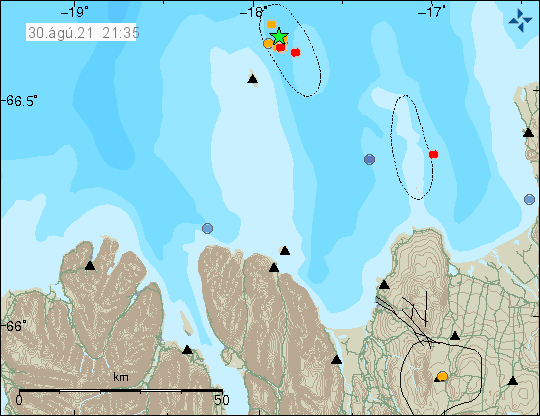
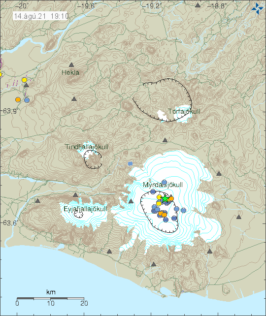
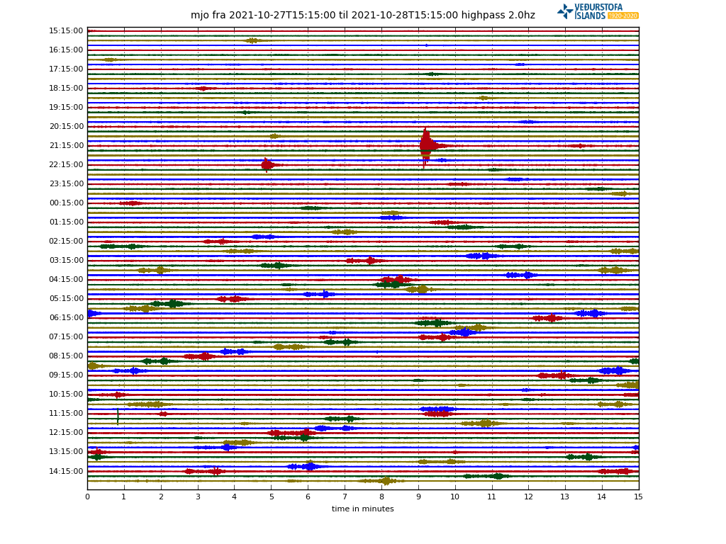
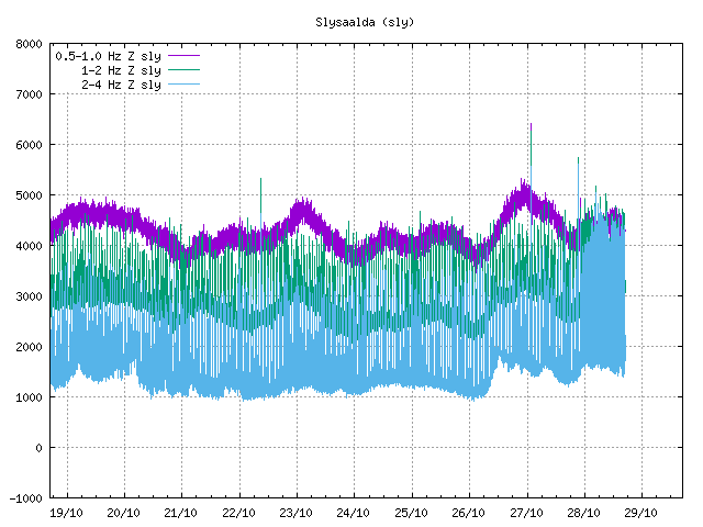
According to an announcement made by Icelandic Met Office there has been a swarm of low frequency earthquakes in Torfajökull volcano since midnight of 28-October-2021.  The earthquakes don’t appear clearly on the Icelandic Met Office map but they can be seen on nearby SIL stations. According to Icelandic Met Office the rate of earthquake activity is about 1 – 2 earthquake every 15 minutes.

A image show earthquake activity in Torfajökull volcano as it appears on nearby SIL station. This is a plot with line showing every hour. The earthquake activity appears as thickness on the earthquake plot.
Earthquake activity in Torfajökull volcano. Copyright of this image belongs to Icelandic Met Office.
Harmonic tremor plot showing the earthquake activity in Torfajökull volcano since midnight as it appears on Slysaalda SIL station tremor plot.
Harmonic tremor activity showing the earthquake activity. Copyright of this image belongs to Icelandic Met Office.

There are two things that can create this type of low frequency activity. The first one is water that has been superheated in the crust. The second option is that magma is now moving in Torfajökull volcano. This type of activity has happened before without any eruption happening. I think that is going to be the same now at the writing of this article. Since this is an active volcano the situation can change quickly and without warning.

There are no web cameras in the area that I know of. It is remote and there is almost no mobile coverage at this location. If there is a mobile connection, it is limited to 2G (GSM) or slow 3G connection.

Earthquake north of Hveragerði town

At 01:28 UTC on 27-October-2021 an earthquake with magnitude of Mw3,3 took place 4 km north of Hveragerði town. This earthquake was clearly felt in Hveragerði and nearby area. No damage has been reported because of this earthquake according to earliest news.

Earthquake north of Hveragerði shown with a green star
Earthquake north of Hveragerði. Copyright of this image belongs to Icelandic Met Office.

There is a chance there is going to be more earthquake activity in this area. But few earthquakes with no more activity is also common in SISZ.

Fewer earthquakes close to Keilir, no eruption in Fagradalsfjall mountain for almost one month

Earthquake activity continues close to Keilir mountain. But it remains at depth of 5 to 6 km and doesn’t show any sign that it is about to move to the surface. More than 10000 earthquakes have been recorded and 18 earthquakes have been recorded with magnitude above Mw3,0. This is according to Icelandic Met Office.

Earthquake activity close to mountain Keilir marked by a green star close to it of the map on Reykjanes peninsula
Earthquake activity close to Keilir mountain on Reykjanes peninsula. Copyright of this image belongs to Icelandic Met Office.

The eruption in Fagradalsfjall mountain (more information at Krýsuvík-Trölladyngja website at Global Volcanism Program) has not been active since 19-September-2021 and there are no signs that the eruption is about to restart soon. Global Volcanism Program no longer updates its information for this volcano as an active eruption. Icelandic scientists in eruptions have not declared the eruption over. It should be expected that the eruption in Fagradalsfjall mountain is over for now, but it can start again at the same location or at new location in few weeks time or maybe even few years from now.

Askja volcano started inflating in August 2021

Icelandic Met Office published the news today that Askja volcano has started to inflate.  This inflation started in August 2021 and has been measured at 5 cm a month. The inflation is happening just outside the Askja lake in area known as Ólafsgígar (Ólaf craters).

Inflation map of Askja volcano. Triangle in the centre of Askja volcano caldera show the location of the inflation in red to blue colour.
Inflation in Askja volcano. Copyright of this image belongs to Icelandic Met Office.

It is impossible to know if this is going to result in any eruption. This inflation however seems to have resulted in earthquake activity in Askja volcano. Most of the earthquakes so far have been minor in magnitude.

Inflation map of Askja volcano. It show displacements in north - south and east - west directions and up displacement of 5 cm
Inflation in Askja volcano. Copyright of this image belongs to Icelandic Met Office.

Icelandic Met Office announcement

Land rís við Öskju (Icelandic)

Uplift signal detected in Askja volcano

Icelandic News

Grannt fylgst með landrisi við Öskju (Rúv.is)

Landris við Öskju í fyrsta sinn í áratugi (mbl.is)

Donations

Please remember to support my work with donations. Thanks for the support. 🙂

Earthquake activity in Esjufjöll volcano

Today (3-September-2021) an small earthquake swarm took place in Esjufjöll volcano. This is the first earthquake activity in a while and suggest that there might be about to start more earthquake activity in Öræfajökull volcano. Since activity in Esjufjöll volcano seems to result in activity in Öræfajökull volcano. How that works and why is unknown.

Few dots in Vatnajökull galcier close to its border. Showing the earthquake activity in Esjufjöll volcano.
Earthquake activity in Esjufjöll volcano. Copyright of this image belongs to Icelandic Met Office.

Last eruption in Esjufjöll volcano may have happened in the year 1927 but that remains unconfirmed. If that eruption happened, it only lasted for 4 to 5 days at most. This area is covered with a glacier, so any eruption there is going to result in a glacier flood.

Donations

Please remember to support my work with donations. Currently I am broke in September and that’s not good. Thanks for the support. 🙂

Minor earthquake swarm in Tjörnes Fracture Zone yesterday (30-August-2021)

Yesterday (30-August-2021) an small earthquake swarm took place east of Grímsey island in Tjörnes Fracture Zone. Two largest earthquakes had a magnitude of Mw3,2.

Earthquake swarm east of Grímsey island. Two green stars on top of each other.
Earthquakes east of Grímsey island. Copyright of this image belongs to Icelandic Met Office.

This earthquake swarm seems to have stopped for now. This area has frequent earthquake swarms and activity in this area of Tjörnes Fracture Zone might start again without warning.

Update on the eruption in Fagradalsfjall mountain on 19-August-2021

This is a short update on the five month eruption day in the Fagradalsfjall mountain that is part of Krýsuvík-Trölladyngja volcano system.

  • The eruption continues its strange cycle of not erupting for few hours and erupting for few hours.
  • The consequence of this type of eruption is that the lava doesn’t flow that far from the crater. It just piles up next to the crater making the structure ever higher. I am currently estimating (this is a guess and might be wrong) the crater at 200 meters high (-+ 50 meters).
  • The eruption has now been going on for five months. Holuhraun eruption in Bárðarbunga volcano in 2014 to 2015 lasted for six months.
  • At the writing of this article there are no new craters open but it doesn’t rule out that new crater might have opened but are hidden under the amount of lava that is around the main crater. As there are some extreme large caves in this lava field. Allowing for a lot of space for new crater to form and start erupting unnoticed.

There are no more updates of the eruption at the writing of this article. That might change without warning but I don’t know if that is going to happen.

Update on the eruption in Fagradalsfjall mountain on 16-August-2021

This is a short update on the eruption in Fagradalsfjall mountain that is part of Krýsuvík-Trölladyngja volcano system.

  • New crater has been confirmed in the eruption in Fagradalsfjall mountain. This crater started to form few days ago. It follows the activity in the largest crater and remains inactive during the time period when there is no activity in the large crater.
  • This new crater is going to change lava flows in the eruption and restart lava flows in the south-Meradalir and Geldingadalir.
  • Current the new crater is building up. It is on the larger crater rim and might be unstable and collapse are likely to happen.
  • Formation of new craters following the formation of this crater is likely. When and where new craters form is impossible to know in advance.
  • It is a question if this is a new phase of the eruption. I currently don’t have an answer.
  • The new crater is visible on all the web cameras.

Fog has been blocking the view of the eruption today and I expect that is going to be the case tomorrow (17-August-2021) and maybe next few days. This fog makes it difficult to see what is going in the eruption.

Earthquake activity in Katla volcano

Today (14-August-2021) an earthquake with magnitude Mw3,1 took place in Katla volcano. Other earthquakes where smaller in magnitude.

Green star in the Katla volcano caldera along with dots showing smaller earthquakes that are spread in the caldera. Showing location of smaller earthquakes that have happened in last few days.
Earthquake activity in Katla volcano. Copyright of this image belongs to Icelandic Met Office.

This earthquake activity appears to be normal late summer activity in Katla volcano. There was a minor increase in conductivity in nearby glacier rivers in last few days, that suggests that cauldrons have been emptying their water this summer. This is normal and happens almost every summer due to glacier melt.

Earthquake activity on the Reykjanes ridge

Yesterday (11-August-2021) there was a earthquake swarm on Reykjanes ridge. This earthquake swarm was not felt because of distance from the coastline.

Few green stars in the far left corner of the Reykjanes ridge along with few red dots. Image is from 11-August-2021
Earthquake activity on Reykjanes ridge. Copyright of this image belongs to Icelandic Met Office.

Largest earthquake in this swarm had a magnitude of mb4,4 according to EMSC. Information about this earthquake can be found here. The distance from the SIL network made it difficult to know when this earthquake swarm started and stopped.

It is unclear if this part of the activity period that Reykjanes peninsula and Reykjanes ridge is now entering and is going to last for few centuries.

Donations

Please remember to support my work with donations. They help a lot more then the income from advertisement (as is the case everywhere).  Thanks for the support. 🙂